


Displaying items by tag: VOR
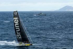
Team Brunel Wins Difficult Leg 7 Of 2017-18 Volvo Ocean Race
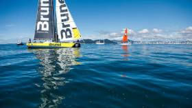
#VOR - Bouwe Bekking has used his veteran nous to fight through all the challenges posed by a difficult Leg 7 of the Volvo Ocean Race and lead Team Brunel to a narrow win over Charles Caudrelier’s Dongfeng Race Team by a matter of minutes.
Team Brunel crossed the line at Itajaí, Brazil at 14:45:18 UTC (15:45:18 Irish time), followed just a quarter of an hour later by Dongfeng at 15:00:08 UTC (16:00:08 Irish time).
The rest of the fleet is not expected until later this week, with Team AkzoNobel currently closest with 260 nautical miles to go, Turn the Tide on Plastic with just over 700 to make up, and MAPFRE still 786 miles away following their emergency repair pitstop last week.
Elsewhere, Vestas 11th Hour Racing, which retired from the leg after dismasting on Friday (30 March), is working through logistical options from the Falkland Islands.
And Sun Hung Kai/Scallyway have finally made landfall in Chile one week after the tragic loss of crew member John Fisher in the Southern Ocean.
The team has been fighting a relentless emotional and physical battle over the last seven days, to ensure the rest of the crew and their Volvo Ocean 65 arrived on shore safely.
For the short term, the team says it will remain in Chile as they debrief and decide on future plans. The team will release more information as it becomes available.
Separately, the Maritime Rescue Coordination Centre Chile has confirmed the search and rescue operation for Fisher has been “deactivated”.
Vestas 11th Hour Racing Dismasts Southeast Of Falklands
#VOR - Vestas 11th Hour Racing has dismasted while racing in Leg 7 of the Volvo Ocean Race, this afternoon Friday 30 March (UTC).
The team is safe and reports there is no immediate danger to the crew.
The team reported that the mast broke at 15:59 UTC (16:59 Irish time) and Race Control was informed of the situation at 16:15 UTC (17:15 Irish time) on Friday afternoon.
The crew was forced to cut away the broken mast to avoid damage to the hull.
The boat is approximately 100 miles southeast of the Falkland Islands and as of 19:00 UTC (20:00 Irish time) was motoring under its own power towards the islands.
At the time of the dismasting, Vestas 11th Hour Racing was sailing in a 25-30 knot northerly wind with three-metre waves.
Other boats in the fleet are in the area and have been informed of the situation in order to render assistance if needed.
The Maritime Rescue Coordination Centre has been advised of the situation, but the team anticipates no outside assistance will be needed to make landfall at the Falkland Islands.
The incident comes just 24 hours after MAPFRE were forced to suspend racing overnight for emergency repairs to their mainsail and mast track.
Leg 7 Position Report, Friday 30 March (Day 13) at 8pm Irish time/7pm UTC:
- Team Brunel - DTF 1,574.1 nautical miles
- Dongfeng Race Team +22.3 nautical miles
- Team AkzoNobel +45.0
- Turn the Tide on Plastic +74.9
- MAPFRE +228.3
MAPFRE Chasing Volvo Ocean Race Fleet Towards Falkland Islands After Sail Repair Pitstop
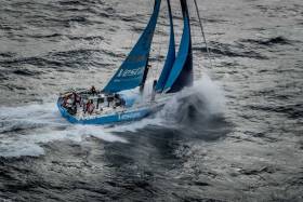
#VOR - Overall 2017-18 Volvo Ocean Race leaders MAPFRE resumed racing on Friday morning (UTC) following a Cape Horn pitstop to make repairs to a torn mainsail, as well as a damaged mast track and boom.
The move — which cost MAPFRE nearly 13 hours when they suspended racing — left the Spanish team 260 miles behind the fleet, with leaders Team Brunel just over 1,600 miles from the finish line in Itajaí, Brazil.
While MAPFRE had prepared for the possibility of a stop to repair the mast track by having shore support on stand-by near Cape Horn, the pitstop became mandatory when the mainsail split into two pieces, torn from luff to leech, just before the Horn.
“We’ve been lucky in a way that we broke it so close by and that we can repair it now with the shore team,” said watch captain Pablo Arrarte.
“The repairs always take longer than you would like,” added skipper Xabi Fernández. “It is not so easy because the repair of the [North Sails 3Di] mainsail has to dry well, but we will start sailing towards Brazil, not at 100% but working as hard as we can to lose the shortest time possible.”
Up ahead, the fleet charges on, pushing east-northeast and passing just south of the Falkland Islands, where conditions remain fierce.
“The Southern Ocean just doesn't want to let us off the hook and keeps us fully in its grip,” wrote Brunel skipper Bouwe Bekking. “The wind direction is such that we are still not really heading north, we’re tight reaching in 28-35 knots in very cold water.
“It is also painful to see we will lose in every position report, with the boats behind getting better breeze. There is one routing forecast where MAPFRE would even win this this leg! But that is yacht racing, not always fun, never predictable and that is what makes it special.”
Team AkzoNobel navigator Jules Salter agreed the weather was far from ideal.
“Not great for tired people and boats,” Salter said. “But we can use these conditions for some quick miles to the northeast as we await the low pressure that chased us down into the Horn to cross Patagonia and eventually catch us as we sail past the Falklands.
“That will give us downwind conditions again, probably with a tricky sea state but at least warming up for each mile north.”
Also making progress is Sun Hung Kai/Scallywag, who continue to make miles towards the Chilean coast following the loss of crew member John Fisher.
A touching tribute to John from Matt Allen, president of Australian Sailing and a friend, can be seen at the end of Friday’s Daily Show below:
MAPFRE Suspends Racing To Deal With Damaged Mast Track
#VOR - While the Volvo Ocean Race fleet mark a major milestone with the passage of Cape Horn today, Thursday 29 March, MAPFRE were forced to suspend racing to work on repairs to their damaged mast track.
A section of the mast track came unglued from the mast five days ago, but until now the team has done a good job of limiting the impact of the damage on its performance through various jury-rig solutions.
But now, with 2,000 miles of racing left to the finish line in Itajaí, Brazil, skipper Xabi Fernández has elected to suspend racing as of 19:32:20 Irish time/18:32:20 UTC, and just six miles west of Cape Horn, to make a more effective repair to both the mast track and mainsail.
Three members of the shore team are in the area to assist the sailors.
Under the rules of the Volvo Ocean Race, a team that suspends racing may use its engine, get outside assistance or take on equipment to make a repair.
The penalty for suspending racing is that you must remain out of the race for a minimum of 12 hours, and return to the same location where you suspended before resuming the race. Given the speed of the other boats, this latest development has the potential to knock the overall race leader back significantly.
The forecast, however, works in MAPFRE’s favour. A ridge of high pressure is expected to slow the frontrunners and allow the trailing boats to catch up.
“A complete restart just after the Falklands” is how leg leader Bouwe Bekking describes it.
Meanwhile, each of the other teams have now rounded Cape Horn, paying tribute to Scallywag’s John Fisher, who was lost overboard on Monday, as they did so.
Team Brunel led the way past the famed Cape, with Brunel skipper Bouwe Bekking saying it was an important stage to get past.
"Well, we are finally around that Cape Horn. It didn’t come easy this leg, as everybody knows, it was a windy one,” he said.
“It’s like a mental milestone, you’re coming from the Southern Ocean and every mile you sail north the weather gets warmer and the finish of the race at The Hague is literally a step closer. It’s a magical picture and a highlight for every sailor…
“But even if we had a little celebration when we went past, we alsohad a toast to John Fisher, who we keep thinking about.”
There were similar sentiments from Charles Caudrelier, the skipper of Dongfeng Race Team.
“Of course the passage of Cape Horn is really nice, and usually everybody is very happy,” Caudrelier said. “But this time we can’t forget what happened to John Fisher on Scallywag, so we can’t be as happy as a normal passage.
“As in the mountains, people who are in the high peaks know the risks. It is much less common at sea, so we are much more shocked. It is a relief to have passed Cape Horn … But obviously, we think a lot about David [Witt] and his team and especially the family of John Fisher.”
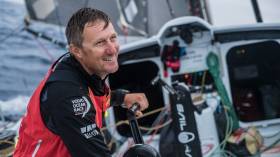
#VOR - Skipper Bouwe Bekking and navigator Andrew Cape have used their veteran nous to sail Team Brunel past Cape Horn at the head of the Volvo Ocean Race fleet.
Bekking and his team passed the famed Cape at 2.01pm Iris time/13:01 UTC (provisional) on Thursday 29 March and earn one point on the leaderboard for being first past the Horn.
But even with a successful passage from the Pacific into the Atlantic Ocean, Bekking said the mood on board during the approach to Cape Horn was subdued.
“The crew is very, very, very tired,” he wrote earlier on Thursday. “Even though we are leading, there is no ‘hurray’ feeling on board … The loss of John [Fisher] is sitting way deeper than people like to admit: I think of him several times in an hour.”
He’s not alone. As the sailors have some more time to digest the news about the loss of Scallywag’s John Fisher, the impact is sinking in.
“This leg has claimed a good man in Fish,” said team AkzoNobel’s Chris Nicholson. “We’ve all been very deeply affected by it and we offer our thoughts to his family and friends.”
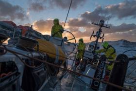
Chasing Team Brunel to Cape Horn is a group of five boats led by Vestas 11th Hour Racing.
“I can speak for everyone on board to say we’re all really, really looking forward to getting there,” said navigator Simon Fisher. “It’s the hardest of the Great Capes to take on and this has probably been the toughest Southern Ocean leg on record for quite some time.
“I’m on my fifth race now and I don’t remember one as hard. As usual it’s blowing about 35-40 knots, so really, there’s just been no let up in the last week and half to these conditions…
“We’re certainly taking stock to think about what it means to get around Cape Horn and also to pause and think about John and the Scallywag guys who have been through a terrible ordeal and this will be a good moment to pay our respect to them.”
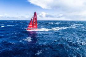
Dee Caffari has taken a crew of novices on Turn the Tide on Plastic across two Southern Ocean legs and today finds herself in the hunt with the group of boats chasing Team Brunel.
“It’s a bit like a proud mum moment,” she said, talking about what it means to her to have shepherded her crew to Cape Horn. “This has been the furthest south most of them have ever been. I’ve got six people who had never been in the Southern Ocean before this race who are about to round Cape Horn, which not many people get to do.
“But the tragic news we’ve had this week … it’s made us all realise how vulnerable we are down here, how hostile the environment is down here, and how quickly things can go bad, and how we’ve all lost a friend. That’s affected everyone quite deeply.
“So we’re saying that this rounding is definitely for Fish.”
As the fleet races around Cape Horn, Sun Hung Kai/Scallywag continue to make progress towards the west coast of Chile, with landfall anticipated early next week.
Leg 7 Position Report, Thursday 29 March (Day 12) at 2pm Irish time/1pm UTC:
- Team Brunel - DTF 1,940.6 nautical miles
- Vestas 11th Hour Racing +35.1 nautical miles
- Dongfeng Race Team +49.0
- MAPFRE +72.7
- Team AkzoNobel +81.4
- Turn the Tide on Plastic +86.8
Updates On Sun Hung Kai/Scallywag & Volvo Ocean Race Fleet
#VOR - Six crews in the Volvo Ocean Race fleet are facing challenging conditions as they race towards Cape Horn, still 900 miles and two days away.
The seventh team, Sun Hung Kai/Scallywag, is working to recover from the tragic loss of crew member John Fisher, who went overboard over 24 hours ago and is now presumed lost at sea, given the cold temperatures and rough sea conditions.
“We are devastated and our thoughts are with John’s family, friends and teammates,” said Volvo Ocean Race President Richard Brisius in a statement this morning, Tuesday 27 March. “This is heart-breaking for all of us. As sailors and race organisers losing a crew member at sea is a tragedy we don’t ever want to contemplate.”
Race director Phil Lawrence provided updates on Sun Hung Kai/Scallywag and the rest of the fleet this afternoon.
“As you can imagine, the Scallywag crew is very shocked, they are very distressed, and our focus at the moment is getting the boat safely to Chile,” Lawrence said. “They are in bad weather conditions and we are sorting out a routing for them that will keep them safe and get them to port.
“The other teams are also in very difficult conditions, with gale force winds, and approaching Cape Horn. So they have a lot on. Yesterday we sent them a short notice about what had happened and this morning we sent them a note that sadly John had not been found.”
Race veteran Bouwe Bekking, skipper of Team Brunel that is currently leading the fleet towards Cape Horn, expressed his feelings which are representative of the sentiment across all of the sailors in the Volvo Ocean Race.
“We are deeply shocked by the loss of John Fisher, known to us sailors as ‘Fish’. Our thoughts are with his family and of course the Scallywag crew. There hasn’t been a moment since we heard that I didn't wake up thinking about him…”
The six boats still racing in Leg 7 are now 900 miles from Cape Horn, with an ETA to round into the South Atlantic on Thursday UTC. Sun Hung Kai/Scallywag is forecast to make landfall in around four days time.
Volvo Ocean Race Sailor John Fisher ‘Presumed Lost At Sea’

#VOR - Richard Brisius, president of the Volvo Ocean Race, has this morning (Tuesday 27 March) issued a statement on Sun Hung Kai/Scallywag crew member John Fisher, who went overboard from the team’s yacht in the Southern Ocean yesterday:
This morning I am extremely sad to inform you that one of our sailors, John Fisher, from Team Sun Hung Kai/Scallywag, is now presumed to have been lost at sea.
This is heart-breaking for all of us. As sailors and race organisers losing a crew member at sea is a tragedy we don’t ever want to contemplate. We are devastated and our thoughts are with John’s family, friends and teammates.
Yesterday, just after 1300 UTC, Race Control for the Volvo Ocean Race were informed of a man overboard situation by Team Sun Hung Kai/Scallywag.
We immediately coordinated with the team as well as the Maritime Rescue Coordination Centre, who have located a ship and diverted it towards the scene. But at current speeds it remains over a day away.
With the rest of the Volvo Ocean Race fleet approximately 200 miles downwind, sending them back upwind to assist, against gale to storm force winds, was not a viable option.
The Sun Hung Kai/Scallywag team conducted an exhaustive search for several hours in extremely challenging weather conditions, but they were unable to recover their teammate.
Given the cold water temperature and the extreme sea state, along with the time that has now passed since he went overboard, we must now presume that John has been lost at sea.
All of us here at the Volvo Ocean Race organisation send our heartfelt condolences out to John’s family, his friends and his teammates and we will do everything in our power to support them in this very difficult time.
Team Sun Hung Kai/Scallywag has now resumed heading in a north-easterly direction.
In fact, the team is currently in a challenging position – the weather is deteriorating and is forecast to be quite severe over the course of today.
The crew is, of course, emotionally and physically drained after what they have just experienced.
Our sole focus now is to provide all the support and assistance that we can to the team.
We are sure that there will be many questions about how one of our sailors was lost overboard yesterday.
We can address those after the team has been fully debriefed.
Today, our thoughts and prayers go out to John’s family and the entire Scallywag team.
Man Overboard From Volvo Ocean Race Team Sun Hung Kai/Scallywag

#VOR - Race control for the Volvo Ocean Race has been informed by Sun Hung Kai/Scallywag of a man overboard incident this afternoon, Monday 26 March, at approximately 13:42 UTC (14:32 Irish time).
The team, along with the Maritime Rescue Coordination Centre (MRCC), has been conducting a search and rescue operation to recover the missing crew member, John Fisher, who was wearing survival equipment when he went overboard in the Southern Ocean.
The incident took place approximately 1,400 miles west of Cape Horn. The remaining crew are reported safe.
The wind in the search area is a strong 35-knot westerly, with accompanying sea state. Water temperature is 9 degrees Celsius. There is daylight, but weather conditions have been forecast to deteriorate in the coming hours.
Given the gale-force conditions, it is not an option to divert any of the other six Volvo Ocean Race competitors, who are at least 200 miles further east and downwind of Sun Hung Kai/Scallywag, to assist in the search operation.
The MRCC has identified a ship approximately 400 nautical miles away and it has been diverted to the scene.
“Naturally we are deeply concerned, especially given the weather conditions, and Race Control in Alicante is supporting the Scallywag team and MRCC throughout the operation,” said the race organisers.
New Data Reveals Higher Concentrations Of Ocean Microplastic Found Nearer Major Cities

#Microplastic - Using data collected by Volvo Ocean Race team Turn the Tide on Plastic, marine scientists have identified 75 particles of microplastic per cubic metre in waters near Hong Kong and 87 per cubic metre along the coast near Melbourne.
Lower concentrations of 39 microplastic particles per cubic meter were found up the east coast of Australia, and values of 48 particles per cubic meter were found in South East Asian waters.
The highest levels of microplastic so far have been found in European waters where the Mediterranean Sea and Atlantic Ocean meet. A peak of 307 particles of microplastic per cubic metre was discovered there.
The tiny particles of plastic, which break down from larger pieces such as single-use plastic bottles, were collected using a state-of-the-art instrument by Turn the Tide on Plastic during the round the world race.
Dr Sören Gutekunst, of the GEOMAR Institute for Ocean Research Kiel funded by the Cluster of Excellence Future Ocean, analysed the preliminary microplastic data at their laboratory in Kiel, Germany.
“We are finding that the concentrations of microplastics increase when the samples are taken closer to higher density populations such as Hong Kong, and in areas where ocean surface currents tend to converge and concentrate marine debris, such as in the Great Australian Bight,” Dr Gutekunst said.
“The potential to model the data in combination with ocean current information will provide an exceptional insight into where plastic pollution is originating and accumulating.
“Regardless of where the data is taken, from remote parts of the ocean, such as the Antarctic, to areas close to major urban conurbations, we are consistently finding levels of microplastics which clearly illustrates how pervasive they have become.”
Microplastics are often invisible to the naked eye and can take thousands of years to degrade. By collecting information on their levels, the mission is helping scientists gain insight into the scale of plastic pollution and its impact upon marine life.
As part of the Volvo Ocean Race Science Programme, during four of the Volvo Ocean Race legs a total of 28 drifter buoys from the NOAA drifter program are being deployed by the vessels, at crucial oceanic regions to measure sea surface temperature and ocean current velocities. This will also help scientists understand how ocean currents could influence the movement of microplastic particles.
Team AkzoNobel are now the second team to have signed up to the Volvo Ocean Race Science Programme, helping capture valuable data from the remotest parts of our seas.
Both AkzoNobel and Turn the Tide on Plastic will be collecting data during the current 7,600-nautical-mile leg from Auckland to Itajaí in Brazil, a race that passes by some of the remotest stretches of ocean on the planet.
In January, it was reported that microplastic particles have been found even in waters close to Antarctica as revealed by data collected on the race’s third leg.
Now with two sets of data to compare, the findings are expected to be more robust and deliver a wider range of data, as the boats may follow different routes and therefore collect information from different parts of the oceans the race travels through.
This oceanographic data will provide important direct measurements to increase knowledge and future insights into ocean health and climate predictions.
“We know very little about exactly how much microplastic is contaminating our oceans so each new data sample is providing valuable information to further our scientific knowledge,” said Anne-Cecile Turner, sustainability programme leader for the Volvo Ocean Race.
“The Volvo Ocean Race provides an exceptional opportunity to directly sample remote areas and to shed light on the global scale and geographical distribution of microplastics pollution in the ocean.
“Having a second boat collecting information on the health of our oceans will only further enhance the quality of our Science Programme.”
Dr Paulo Mirpuri, president of Volvo Ocean Race principal sustainability partner The Mirpuri Foundation said: “We were not expecting microplastic to be found in the most remote areas of our seas like the Southern Ocean. This came as a complete surprise to us, the dream that we would still have pristine and plastic free seas somewhere in this planet is gone and means the problem is a lot bigger than our initial assumptions. We all need to take action right now and hope it is not too late.”
The Volvo Ocean Race Science Programme is funded by Volvo Cars, which is donating €100 from the first 3,000 sales of the new Volvo V90 Cross Country Volvo Ocean Race edition to support the initiative.
“Volvo Cars is delighted to be supporting this innovative programme, whose approach to environmental care is a strong fit for us - not least as we head towards an electric future,” said Stuart Templar, director of sustainability at Volvo Cars.
“We are keen to get an even clearer picture of the scale of the problem as the boats now head into leg seven and the most remote waters of the world. This sets an invaluable benchmark for future research and action.”
Respite For Volvo Ocean Race Fleet As New Leader Emerges
#VOR - As the winds moderated to 20-25 knots earlier today (Sunday 25 March), the seven Volvo Ocean Race boats racing through the Southern Ocean towards Cape Horn are taking the opportunity to regroup before the next gale.
Bouwe Bekking’s Team Brunel had taken a more northerly option over the past 36 hours compared to the bulk of the fleet and it appears to have paid off, with the yellow boat now sliding south in front of the pack with a 23-nautical-mile lead.
“Some awesome sailing, but also very stressy times, especially when you need to gybe,” Bekking wrote. It’s worth noting his northerly option reduced the number of gybes compared to most of the fleet.
“We had some winds of 40 to 45 knots which is no fun, actually it is pure survival mode, but you know the others aren’t holding back either… No way. It is the way we sail.”
There is a group of three teams chasing: Dongfeng Race Team, Turn the Tide on Plastic and Vestas 11th Hour Racing, all within a couple of miles of each other and looking to close the gap.
Team AkzoNobel, another proponent of the northern option is pushing to re-join the pack, but will struggle to slot in ahead of this group.
MAPFRE, who had been either at or near the front since the start of the leg, has fallen off the pace today. With the winds easing, the damage to their mast track is preventing the team from shaking out a double-reef in the mainsail.
While the rest of the fleet adds sail area in the moderating winds, MAPFRE is sailing underpowered, and at times up to 3 knots slower.
“We’ve made a small repair to sail with two reefs and now we are trying to develop that to sail normal from here to the end of the leg,” saidPablo Arrarte, from a subdued MAPFRE. “It’s difficult. We’re still working on it … We don’t have the full solution yet … We have 20 hours until the breeze comes back up so we will try to fix it before then.”
One hundred miles further back, Sun Hung Kai/Scallywag is back on its feet after dealing with problems of their own following an accidental gybe on Saturday that put the boat on its side in big winds and heavy seas.
“Your initial reaction is to just stick to the process and look after the people and the boat,” said skipper David Witt. “But once you get through it and get the boat up and running again, you understand the enormity of the job all of the skippers in this race have, to ensure the welfare of the people on board.
“We’ve tipped it over in the middle of the Southern Ocean in the middle of the night and the closest thing to us is a satellite. It really hits home … But our guys don’t give up and they deserve a result on this leg, that’s our responsibility now.”
Earlier on Sunday morning, Brunel had led the fleet past Point Nemo, the most remote spot on the world’s oceans.
Point Nemo is nearly 1,400 nautical miles from the nearest land, meaning the closest people to the sailors — apart from their fellow competitors — are the astronauts on the International Space Station, some 220 nautical miles overhead.
Leg 7 Position Report, Sunday 25 March (Day 8) at 2pm Irish time/1pm UTC:
- Team Brunel - DTF 3,692.89 nautical miles
- Vestas 11th Hour Racing +23.20 nautical miles
- Dongfeng Race Team +24.71
- Turn the Tide on Plastic +25.48
- Team AkzoNobel +43.45
- MAPFRE +43.85
- Sun Hung Kai/Scallywag +138.21


 Michael Murphy Schull Harbour Sailing Club (SHSC), Eric Coogan Heineken Ireland, Mark Murphy, Commodore SHSC, Jack Allen SHSC, Carmel O'Regan SHSC, Cornelious Ndlovu, Schull Harbour Hotel Operations Manager and Derval Murphy SHSC")

