


Displaying items by tag: Weather
2023 the Warmest Year on Record For Ireland - Met Éireann Climate Report
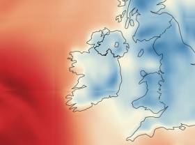
This year is expected to be the warmest 12 months on record for Ireland, Met Éireann’s provisional state of the Irish climate report says.
Temperatures in 2023 beat the previous warmest year of 2022, and for the first time, Ireland’s annual average temperature is greater than 11°C (record length 124 years), it says.
2022 was the previous warmest year on record at nearly 10.9°C, narrowly beating 2007 by just 0.1°C.
Keith Lambkin, Head of Climate Services at Met Éireann said these record-breaking extremes “have knock-on consequences to much of society”.
“Past weather events are no longer a reliable indicator of future weather events, but knowing this allows us to better plan and adapt to our changing climate,” he said.
 Ireland Temperature anomalies
Key points of the report are that :
- 2023 was the warmest year on record for Ireland (record length 124 years).
- For the first time, Ireland’s average annual temperature rises above 11°C.
- 2023 saw the warmest June on record.
- 2023 saw the wettest March and the wettest July on record.
- For the first time in 23 years, four months of the year were within their top 5 warmest months on record (average stays between one and two months every year since the year 2000).
- January 2023 observed the lowest temperature of the year with -7.2°C on Tuesday, 17 January, at Lullymore Nature Centre, Co Kildare.
- February 2023 was ranked 5th mildest and 6th driest February.
- March 2023 was the wettest March on record.
- April 2023 saw storm Noa brought storm force winds and waves to up 17.3 m on the Kerry and Cork coast.
- May 2023 was ranked 2nd warmest May.
- June 2023 became the warmest June on record with above 16°C average temperatures for the first time.
- July 2023 was the wettest July on record and wettest month of 2023.
- Significant flooding during storm Betty occurred in August.
- September 2023 was the 3rd warmest September with rare September heatwaves and the highest temperature of the year with 29.1°C on Friday 8th September 2023 at Lullymore Nature Centre, Co Kildare.
- October 2023 was the 2nd wettest month of year. Cork Airport recorded its highest October rainfall ever, with 222% of October’s 1981-2020 long-term average. Storm Babet caused significant flooding.
- November saw more rainfall and flooding.
- Eleven named storms during the year, and three named storms in December – Elin, Fergus and Gerrit.
Met Éireann notes that it has been over a century since the coldest March (1919), April (1922), May (1923), July (1922), August (1912), September (1918) and November (1919).
Since 2000, on average, one or two months of the year have recorded their top five warmest temperatures, it says.
“For example, in 2022, we had two months within their top 5 warmest. However, in 2023, four months reached the “top five warmest on record”: February (5th warmest), May (2nd warmest), June (warmest ever) and September (3rd warmest),” it says.
For the first time in a single year since 1941, two months observed their wettest on record, March and July, it notes.
This June Hottest on Record - Met Éireann
Met Éireann says that June 2023 is the hottest June on record, while the recent marine heatwave has brought extreme sea-surface temperatures to Irish shores.
Met Éireann says that provisional data shows that Ireland has experienced its first June with 16+°C average temperatures.
It says that this exceeds the previous June record, which had held for 83 years.
“June 2023 is set to be more than half a degree higher than June 1940,” Met Éireann says.
The highest temperature of 2023 so far, at 28.8°C, was reported at Oak Park in Co Carlow on Tuesday, June 13th.
It says this is the third consecutive year that a temperature at or above this value has been observed in Ireland.
“Although temperatures have fallen in recent days, they will not prevent this June’s record-breaking situation,” Met Éireann’s climatologist Paul Moore says.
“This year’s particularly warm June is part of an observed warming trend, and our research shows that this trend will continue,” Moore said.
“Our recently published TRANSLATE project provides a reminder that right across society, we need to understand and plan for a changing climate,” he said.
“An average monthly temperature of greater than 16°C has been seen in July and August but never before in June,” Moore said.
“June 2023 was well above normal due to persistent warm days and nights,” he said, and 23 of 25 Met Éireann primary weather stations have shown their warmest June on record.
“In early June, cool easterly winds on the east coast meant that Phoenix Park and Dublin Airport stations were cooler, but they still show their warmest June since 1976,” he said.
Met Éireann researcher Dr Pádraig Flattery said that “as climate change continues, we can expect further records to be broken and more frequent and extreme weather events”.
“A warmer atmosphere can hold more moisture (about 7% for every 1°C of warming), and warmer waters, in turn, provide more energy for storms and can contribute to extreme rainfall events,” he said.
This June, and especially over the past two weeks, Ireland has seen nine days of intense thunderstorm activity, with heavy downpours, lightning, and at times, hail, Met Éireann said.
“While this prolonged spell of thunderstorms has not been the norm in Ireland,…..we are likely to see more of this type of weather as the climate,” it said.
The World Meteorological Organisation recently warned that Europe is warming twice as fast as other continents.
16,000 people died as a result of extreme heat last year, and widespread droughts caused significant economic impacts. The rate of June heat waves has tripled in Spain in the past 12 years. June 2023 was also the warmest June of record in Britain.
Of the top ten warmest Junes on record, half of those have occurred since 2005, that is (in order of warmest) 2023, 2018, 2010, 2006 and 2005, Met Éireann says.
It says Athenry, Co Galway and Shannon Airport, Co Clare experienced 27 consecutive days with maximum air temperatures > 20.0 °C, ending on Saturday, June 24th, 2023.
“Summer 1995 observed 36 consecutive days at various stations in Leinster, ending on Saturday 26th August 1995,” it says.
It says Newport, Co Mayo experienced five consecutive nights where air temperatures did not fall below 15.5 °C, ending on Wednesday, June 14th, 2023.
Four Irish Names on New International Storm List
Barra, Méabh, Pól and Seán are among the names that have made it on the latest international storm list for 2021 to 2022.
Diarmuid was put to a vote along with Duncan, Dudley and Dafydd.
However, Dudley was the winner – perhaps influenced by the “magic” of the fictional character in JK Rowling’s Harry Potter series of books, three weather services have said.
The list for the 2021-2022 storm season was drawn up by Met Éireann, the British Met Office and the Dutch weather service KNMI.
Met Éireann and the British Met Office have been working together since 2014 on the “storm names partnership” and were joined by KMNI in 2019.
Similar to previous years, each weather service has contributed names reflective of their nation and culture, mainly suggested by members of the public.
The new list begins with Arwen, and continues with Barra or Finbar, Corrie and Dudley.
Also selected are Eunice, Franklin, Gladys, Herman, Imani, Jack, Kim, Logan, Méabh, Nasim, Olwen, Pól, Ruby, Séan, Tineke, Vergil and Willemien.
“Last winter was relatively quiet with only one storm named by Met Éireann - Storm Aiden at Halloween,” Met Éireann’s head of forecasting Evelyn Cusack noted.
“Once again Met Éireann will continue to work with our national weather service colleagues in the UK and Netherlands by continuing to provide a clear and consistent message to the public, and encouraging people to take action to prevent harm to themselves or to their properties at times of severe weather,” she said.
“Also this month we are delighted to see the launch of our new audio weather forecasts, where people can listen to the latest forecast delivered by our team of Met Éireann forecasters,” Cusack added.
“We’re all aware of some of the severe weather that has been witnessed across Europe and globally in recent months,”Will Lang, Met Office head of the national severe weather warning service said,
“ We work to use any tool at our disposal to ensure the public is informed of potential risks, and naming storms is just one way we do that,”Lang explained.
“Storms are not confined to national borders - it makes a lot of sense to given common names to such extreme weather events,” Gerard van der Steenhoven, KNMI director general, said.

Developing out of the successful Weather and Sailing conferences is this short webinar focusing on weather and the single-handed sailo scheduled for next Tuesday, December 15.
The two speakers for this joint webinar, which will focus on the challenges faced during the 2020 Solitaire du Figaro and during the current Vendée Globe, will be Tom Dolan and Andi Robertson.
Irishman Tom Dolan, skipper of Smurfit Kappa finished fifth overall in the shortened Solitaire du Figaro 2020. This excellent achievement made the Concarneau based sailor the highest placed non-French skipper since 1997. Tom will reflect on the three races in the series and the challenges that the weather presented.
The Solitaire du Figaro has acted as a training ground for many single-handed sailors who have both competed in and won the Vendée Globe around world race.
 Tom Dolan is doing a weather talk next week for the RIN in aid of Sailing into Wellness
Professional sailing journalist and broadcaster Andi Robertson will update us on how things are going on the Vendée Globe race track with particular emphasis on specific weather challenges experienced in the race so far and the likely weather patterns the Vendée fleet will experience in the Southern Ocean. Andi hosts the daily Vendée Globe update at 1230hrs UTC and is based at the Vendée Globe Race HQ at Les Sables d’Olonne.
There is no charge for attending the webinar however prior registration is required. Registration is now open, just click on the registration button below.
Tom and Andi are both supporters of the charity Sailing Into Wellness which uses sailing to promote physical and mental-being.
Please visit the Sailing into Wellness website and contact the charity to make a donation. Thank you.
Mayo Sailing Club Upgrades Weather Station for More Accurate Forecasting on Wild Atlantic Way

What is the number one topic of conversation in Ireland? We all know the answer: It’s the weather. We also know that the forecasts we hear on the radio or see on the telly are, shall we say, not always quite accurate. Some might even say they are only valid for Dublin. And when have you ever heard ‘them’ say “there will be sunshine spreading from the west”? Wait no longer. Now you can go to the Mayo Sailing Club website to get a full picture of what the weather is doing now and about to do in the near future.
 MayoSailingClub.com website showing the menu to the Anemometer
In County Mayo, those in the know have long relied on resources other than the weather service to get their fix. For years, the Mayo Sailing Club (MSC) anemometer has been used by the RNLI and Coastguard as well as many fishermen and farmers for an accurate picture of what is happening with the wind on Clew Bay at a given time. Windguru has also been a favourite for local weather forecasts with people checking out the Bertra and Mulranny “spots”.
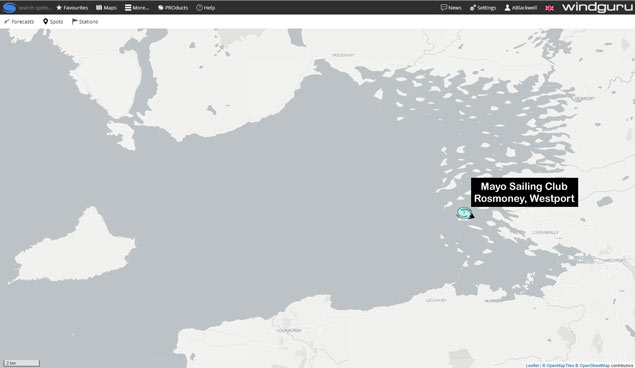 Location of the Mayo Sailing Club weather station on Inishlyre Island in Clew Bay
Windguru was originally conceived for surfers who wanted accurate weather and wave forecasts. Whereas there are many “spots” where Windguru forecasts can be looked up on the web or in the app, there have to date only been seven actual weather “stations” where wind, rain and temperature data is collected and used in their forecasting models; these were in the east and south of the country. The forecasts for the weather “spots” here in Clew Bay and elsewhere were extrapolated from these remote “stations”.
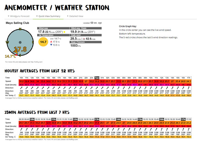 The current weather at the Mayo Sailing Club weather station on Inishlyre Island in Clew Bay under the ‘Quick View Summary’ tab
Westport is now the centre of weather forecasting for the Wild Atlantic Way
Mayo Sailing Club has completed a significant upgrade to its weather station. By upgrading the physical weather station technology, the detailed live data from the station can now be shared with global weather forecasting networks such as Windguru. This is a significant development as it means that visitors to MayoSailingClub.com and users of Windguru can now get detailed and accurate information on the weather we are currently experiencing as well as on the trends that led to this, resulting in much more accurate predictions as to the weather we are likely to get in the coming hours and days. To view the data, which includes current wind strength, wind direction, variability of wind direction, precipitation (rain), cloud cover, temperature, air pressure, and light levels, as well as the current webcam view from Inishlyre Island, just navigate to the MSC Anemometer page and click on “Detailed View & Graphs”.
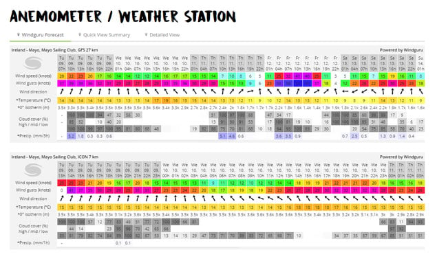 A sample of the ‘Windguru forecast’ tab showing the longer range GFS 27 prediction and the ICON 7 three day prediction.
 The current weather at the Mayo Sailing Club weather station on Inishlyre Island in Clew Bay under the ‘Quick View Summary’ tab
Current Weather and Forecasts
A visitor may also click on the “Windguru Forecast” tab to get a detailed forecast. This is based on the actual current situation and trends. It is therefore as accurate as it can be based on the most current meteorological prediction models. Usefully for Ireland, it also includes rainfall predictions. While this data can appear a little daunting at first, what you are seeing are several different weather prediction models which are summarised below:
GFS Model
GFS stands for the Global Forecast System. It is run by National Centers for Environmental Prediction, USA. The GFS is run four times per day and is a global model so it covers the entire Earth! Since January 2015 GFS produce forecasts with resolution of 27 km out to 240 hours.
WRF Model
The Weather Research and Forecasting (WRF) Model is also US based. It is a next-generation mesoscale numerical weather prediction system designed to serve both operational forecasting and atmospheric research needs.
ICON Model
The European Global ICON Model is the newest and some would argue, the most accurate. ICON 13 covers the planet and offers forecasts in 3 hour steps for the next 180 hours, updated 4 times per day. The regional ICON 7 model with 7 km resolution covers Europe with forecasts in 1 hour steps for the next 78 hours.
Remember, these are different computer programs using the currently available information to predict the future, so inevitably their predictions will differ slightly. Despite that, you may be surprised by just how reliable they are – particularly the ICON 7 and WRF 9 models, which give you the next three days. They will often accutately predict rainfall to the hour. The fact that these predictions are now using live information gathered by Mayo Sailing Club means that the forecasts will be much more reliable than in the past when they were extrapolated from weather stations that were hundreds of miles away. The next time you chat with friends and family about the weather you will have the opportunity to dazzle and amaze with your own astonishingly accurate predictions!
Location
Courtesy of the Gibbons Family of Inishlyre Island, the Ultrasonic Anemometer has been located 27 meters above sea level on the island’s summit 53° 49.5'N 9° 39'W. This provides a clear view of all quarters enabling a representative sampling of the local wind in Clew Bay.
Principle of Operation
The can-sized wind sensor measures the time taken for an ultrasonic pulse of sound to travel from the North transducer to the South transducer and compares this with the time for a pulse to travel from S to N transducer. Likewise, times are compared between the W and E and the E and W transducers. If for example, a Northerly wind is blowing, then time taken for the pulse of sound to travel from N to S will be faster than from S to N, whereas the E to W and W to E times will be the same. The wind speed and direction are then calculated from the differences in the times of flight on each axis. This calculation is independent of error sources such as temperature and mechanical friction etc. Being solid state (no moving parts) the anemometer is virtually maintenance free. It is powered by battery which is kept charged by a large solar panel.
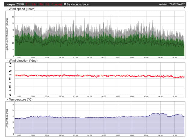
Using a data logger and a modem the data is sent via GPRS and the internet to a remote computer where the Wind Speed and Direction for the last 8 hours are displayed on two graphs which scroll forward with time.
Data is collected every 30 seconds and the graphs are updated every 5 minutes when the remote computer polls the data logger. These real-time graphs are available on www.mayosailingclub.com for members and guests to check the current local weather at Clew Bay anytime. This is an important safety feature for members and the general public who use Clew Bay.
For more information on what the weather is going to be like visit: www.mayosailingclub.com
'Beast from the East' Hits Ireland As 'Status Red' Alert Issued
As expected 'The Beast from the East' arrived through the night and forecasters now say this severe winter weather is considered very likely to last a week or longer. It's time to check the boat and avoid the five most common wintersing mistakes for boatowners.
A snow-ice warning has been issue for Dublin, Kildare, Louth, Wicklow and Meath.
Heavy overnight snowfall has led to accumulations of snow between 5 and 10cm. Snow showers will continue to occur during today and again tonight with further accumulations. Total snowfall up to midday Thursday may reach 25cm.
Like everyone else, sailing clubs and marine trade are coping with the effects of the snowfall. Among some early postponements of events is Friday's Cork Week launch and tomorrow night's Glenua Presentation “From the Aegean to the Fastnet Race 2017".
The RStGYC in Dun Laoghaire has notified members that the clubhouse is closed today and until the removal of the weather warning. The National Yacht Club will close at 3pm.
Current forecasts are for conditions to worsen before improvement with tomorrow and Friday looking like potential blizzard conditions. Add this to the below freezing temperatures and a wind chill of up to -11c tomorrow morning it is time to batten down the hatches.
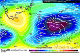
Details of what's next on the weather front are of course sketchy but the depth of cold air over Ireland means temperatures are well below freezing, and that further snowfall is a strong possibility in the east, south and perhaps coastal areas of north and west as well, and we are seeing some charts on the most reliable models that are real jaw-droppers for snowfall potential.
Here's some updates via social media from around the coast:
A Red Weather Warning has been put into effect by Met Éireann. Insurers Allianz say stay safe and observe all advice from state agencies.
Dun Laoghaire Harbour based MGM Boats has been busy making desktop snowmen...
Viking Marine in Dun Laoghaire are selling sledges...
And in Cork Harbour, Eddie English predicts temperatures as low as minus 5....
The CH Marine chandlery has been forced to close in Cork today but the Skibbereen branch IS open....
Cork Sculling Ladder Action Postponed

#Rowing: Competition in the Cork Sculling Ladder has been postponed this weekend because of the forecast of bad weather. The organisers have chosen Sunday, October 29th, as the date for the next action in the event. Jack Dorney of Shandon and Margaret Cremen of Lee top the rankings after the time trials.
Waves Crash Over Great South Wall at Poolbeg on Dublin Bay
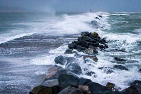
As Ireland braces itself for stormy conditions next week, photographer John Coveney captured waves breaking over the Great South Wall at Poolbeg on Dublin Bay during yesterday's Southeasterly Gale.
Met Eireann say South to southwest winds will continue to occasionally reach gale force 8 for a time this morning on Irish Coastal waters from Erris Head to Bloody Foreland to Fair Head.
The outlook for a further 24 hours until 0600, Sunday is for moderate to fresh west or southwest winds becoming southwesterly everywhere on Saturday afternoon. Winds veering west to northwest on south and west coasts late Saturday and early Sunday.
Wind Warning For West Coast This Monday Night
#Weather - Batten down the hatches: the West of Ireland is in for a windy one this coming Monday night (5 February).
The latest maps from Dark Sky show a large weather mass of high winds barrelling across the Atlantic from the west on Monday evening, reaching the Wild Atlantic Way after midnight.
Before that, Met Éireann warns to expect of heavy rain and windy weather nationwide with strong southeast winds.
Climate Change Prompts New Coastal Erosion & Flooding Plan

#CoastalNotes - Coastal defences and protections against flooding are outlined in a new Department of Transport plan to prepare Ireland for future climate change, as The Irish Times reports.
The draft consultation report, Developing Resilience to Climate Change in the Irish Transport Sector, details measures such as coastal flood defences at Shannon Airport and the railway line at Rosslare Harbour, the latter of which is inching ever closer to the cliff on the eroding shoreline.
As previously reported on Afloat.ie, the East Coast line suffered significant damage north of Wicklow town during last month’s Storm Angus.
Predicted rises in temperatures and sea level over the next century are expected to bring more of such storms, with heavier rainfalls and an increased risk of flooding and landslides in prone areas.
All of this has prompted the new plan to identify key remedial works for future-proofing the country’s transport infrastructure.
The Irish Times has more on the story HERE.


, and Dermot O’Kane, Head of Sales, Esri Ireland. Esri Ireland is announcing that its digital mapping system is helping DURL to prevent 13 million litres of polluted wastewater from entering Dublin rivers annually, by locating misconnected household appliances that are expelling polluted water")


