Menu

Ireland's sailing, boating & maritime magazine

Inland afloat headers


Displaying items by tag: Whales

The Centre of Excellence for Climate Action & Sustainability at Myross Wood House in Leap is the location for this year’s WHALE TALES.

West Cork is a good location for the event, which will start on Friday evening and continue throughout the weekend until Sunday, open to both Irish Whale and Dolphin Group (IWDG) members and the general public.

This annual meeting of the IWDG is an opportunity for all whale (and dolphin) enthusiasts to join us over a weekend to share our appreciation for these charismatic mammals and learn more about the conservation and research work being carried out by the IWDG and others.

This year’s event is being held at CECAS, The Centre of Excellence for Climate Action and Sustainability, the former religious retreat,

The weekend will start with a humpback whale film/ presentation on Friday evening, relevant to anyone living in West Cork who has ever been fortunate enough to see this iconic species. Saturday will be a “Whaley day” of news and stories from IWDG officers and an opportunity to introduce and discuss topics, including offshore renewables and Marine Protected Areas (MPAs), with plenty of time for Q&A. More importantly, this is a great opportunity to share your stories and mingle with like-minded folk, passionate about our marine environment and its wildlife.

The weather will dictate activities on Sunday morning, but the options are to hold a land-based whale watch from a local vantage point or deliver a simulated live-stranding exercise on a local beach or at the venue.

The IWDG AGM is on Saturday afternoon at 17:00, open only to current members More information from IWDG on Email: [email protected]

Published in Marine Wildlife
Tagged under

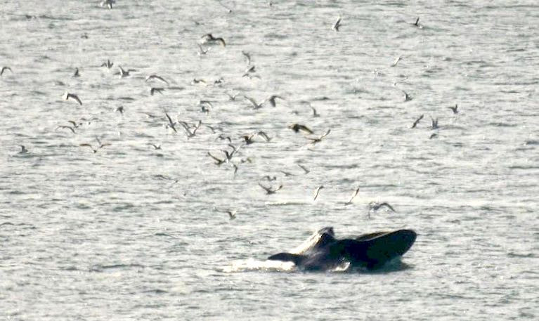
Stunning humpback whale images have been captured by a postgraduate student east of the Fastnet lighthouse during a research trip off the West Cork coast.

Miguel Blázquez Hervás, a PhD student at the Atlantic Technological University (ATU) in Galway, was on his first trip out to try and sight some humpback whales when he came across a pod of three.

“I arrived down in West Cork last Saturday (May 28) and took the Cape Clear ferry Carrig Mhór,” Blázquez Hervás, from Madrid, Spain, said.

He was participating in a training course run by the Irish Whale and Dolphin Group (IWDG).

“The weather was good but quite windy, so it was a little bumpy. I wasn’t expecting to see anything and when I saw the three whales, along with some common dolphins which were also feeding on schools of fish,” he said.

The vessel was about 10km east of the Fastnet lighthouse at the time.

The humpback is one of 24 species of whale regularly seen in Irish waters, and there have been over 1,000 validated sightings reported.The humpback is one of 24 species of whale regularly seen in Irish waters, and there have been over 1,000 validated sightings reported

One of the three whales has been catalogued by the IWDG with the identification number HBIRL67, but the other two had no previous records.

The HBIRL67 whale is a female and can be recognised by the tooth rakes on the left side of her fluke, the two lobes of the tail. The rakes may have been caused by an encounter with killer whales.

She has been an annual visitor to Irish waters since 2016, according to the IWDG.

The humpback is one of 24 species of whale regularly seen in Irish waters, and there have been over 1,000 validated sightings reported.

In 2019, the IWDG confirmed a positive match between a humpback photographed at feeding grounds off the Irish south coast in 2015, and an animal photographed at breeding grounds in the Cape Verde Islands off West Africa that year.

Blázquez Hervás’s postgraduate research involves trying to determine the length and body condition of humpback whales in Irish waters using a drone, along with an analysis technique to determine abundance and trends over time.

His postgraduate scholarship is grant-aided by Fundación Mutua Madrileña

Published in Marine Wildlife
Tagged under

Ahead of its broadcast this weekend, Newstalk previews A Sea of Sound, a new radio documentary that explores the impact of noise pollution on marine wildlife.

Marine mammals such as dolphins and whales effectively ‘see’ through sound in the water. “So to understand the life they lead, as the Irish Whale and Dolphin Group’s Simon Berrow says, we need to “think acoustically”.

Producer John Higgins spoke to Berrow and other environmental stakeholders for the documentary, which also features some of the remarkable sounds of whales and dolphins communicating beneath the waves — and explores the sounds that threaten them, from seismic surveys to military sonar and more.

A Sea of Sound will be broadcast on Newstalk this Sunday morning 27 March at 7am, with a repeat on Saturday 2 April at 9pm. It will also be available as a podcast.

Published in Marine Wildlife

 The Irish Whale and Dolphin Group is reporting a sighting of large Fin Whales close to the shore at Hevlick Head on the County Waterford Coast.

Andrew Malcolm photographed and identified the pod close to shore feeding.

There were at least five animals present in two groups on Christmas Day.

More details from the IWDG here.

Published in Marine Wildlife
Tagged under

Whales are known to be disturbed by the noise of ships and oil and gas drilling, but now a new study says that bottom trawling can also upset marine mammals.

As the Irish Independent reports today, scientists at NUI Galway’s (NUIG) Ryan Institute have found that the sound generated by trawling for fish around underwater canyons is amplified and may affect marine mammals’ ability to hunt and navigate.

The team used hydrophones to record the impact on the marine environment of trawlers in two surveys in the Irish Sea and Celtic Sea.

Ecologically sensitive areas of the oceans need stronger environmental protection from the wide variety of potential pollution sources, including ships, deep-sea mining and bottom trawling, the team suggests.

The scientists modelled how the noise generated by bottom trawling could travel through the water column, along the seabed, and through a 20km long submarine canyon in the Porcupine Basin off the south-west Irish coast.

They found the noise funnels through underwater canyons and into deeper waters, affecting marine mammals feeding and migrating.

They also discovered that “modelled trawler sound” generated on the seabed travels underwater more “efficiently” than sound generated at the surface by boats.

Eoghan Daly, a PhD researcher with NUIG’s Irish Centre for Research in Applied Geosciences (iCRAG), said that raised levels of marine noise can “interfere with a marine mammal’s ability to communicate, hunt and navigate using echolocation”

“Human-derived noise in the world’s oceans comes from many sources”, but “ bottom trawling’s impact has received “little attention to date”, he said.

“In an ocean already faced with plastic pollution and climate change, a better understanding of trawler noise pollution will highlight it as another human impact on the marine ecosystem,” Daly said.

The NUIG team’s findings have been published in the scientific journal, Marine Pollution Bulletin.

The team hopes their research will inform improved environmental regulations near key marine habitats, marine protected areas (MPAs) and any additional special areas of conservation in Irish waters.

Ireland has set a target of designating a total of 30% of its maritime area as MPAs by 2030.

“The research fills an important gap in marine noise pollution monitoring,” Dr Martin White of NUIG said.

“Areas such as the Porcupine Basin and the wider European continental margin are ecologically sensitive, and trawlers operating in this part of the Atlantic Ocean have more powerful engines and heavier gear,” he said.

“The enhanced currents and nutrient mixing in these parts of the ocean help create good conditions for cold-water coral mounds and for associated invertebrates, fish and mammals to thrive,” he noted.

Marine life should be protected from the wide variety of pollution sources, including ship noise, pile driving and from bottom trawling, as we now know,” he said.

Read The Irish Independent here

Published in Marine Science
Tagged under

The waters off the south coast of Ireland have been selected as the study location for Ireland’s first real-time acoustic monitoring project of large whales, with the aim to relay warning alerts to maritime traffic to reduce the risk of disturbance and ship strikes.

The Automated Cetacean Acoustics Project (ACAP) is being undertaken by Ocean Research & Conservation Ireland, a “for-impact” non-profit organisation based in Cork, in partnership with the Rainforest Connection and supported by Huawei Ireland.

Huawei Ireland is providing a research grant with technological support through its global TECH4ALL initiative. TECH4ALL is Huawei’s digital inclusion initiative, using technology, applications and skills to empower people and organisations everywhere.

90% of Ireland’s international trade travels by sea, with the South Coast of Ireland one of the busiest heavy ship shipping lanes in the world. Thousands of large container ships pass through it from Eastern Canada to Liverpool and other European ports annually, as well as additional pleasure boats, speed crafts and eco-tour operators.

The South Coast is also an important foraging, resting and reproductive habitat for 25 cetacean species (whales, dolphins and porpoise) and particularly for large Humpback, Fin and Minke whales. Heavy ship traffic places whales at an increased risk of ship strikes causing injury or even death, and also raises the ambient noise pollution affecting all the species present.

The new study will see the deployment of acoustic monitoring equipment in the Celtic Sea at locations where sightings of whales and other wildlife have been recorded. The equipment will be able to listen for movements of whales, and with the help of machine learning models to enhance data analysis, for the first time provide near real-time detection. This will provide multiple benefits - helping with the identifying and classification of species in Irish waters, their distribution and behaviour, and most importantly, the development of an early warning system that will enable ships to reduce their speed in time to lessen the considerable risk of ship strikes.

The project will see Ireland leading the way in the advancement of policy and programmes that respect and protect marine wildlife informed by near real-time data available for the first time, with the help of Rainforest Connection and Huawei Ireland. Not only will the detections be able to help inform policy and decision-makers in the establishment and management of potential marine protected areas (MPA’s), they will also be used for education and made available to the wider public to hear the symphony of cetacean sounds.

Commenting, lead researcher Emer Keaveney, Marine Mammal Ecologist, Ocean Research & Conservation Ireland said: “Recent advances in technology provide increasing opportunity to use these innovations for good and to enhance our understanding of the natural world. This is such an exciting time as now we have a chance to peer inside the secret world of whales in Irish waters, and directly improve their welfare and conservation”.

“We are a voluntary organisation that relies heavily on third party and private assistance, so we are delighted to have this opportunity to work with Huawei Ireland.”

Emer Keaveney will discuss the project via livestream as part of the annual Huawei Connect summit, which takes place in Shanghai and online between 23rd - 26th September. Emer Keaveney is the only Irish speaker at the summit, which focuses on AI, 5G and digital innovation.

Commenting on the announcement, Tony Yangxu, CEO Huawei Ireland said: “Huawei has been a trusted partner for over 16 years in Ireland, and we are excited to be supporting Ocean Conservation & Research Ireland as our very first fully funded TECH4ALL initiative in Ireland.”

“Huawei believes that no one should be left behind in the digital world and we have made it our mission to put digital inclusion front and centre of our business. Our TECH4ALL programme centers on developing digital inclusion and empowerment initiatives with measureable outcomes. One of its many purposes is to help accelerate the UN’s SDGs and we hope that this project with ORC Ireland can contribute to that.”

Published in Marine Wildlife

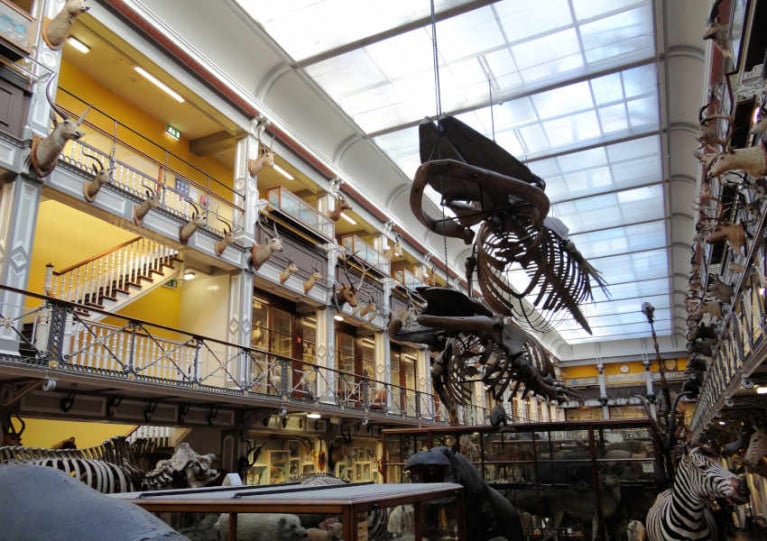
The giant whale skeletons of Dublin’s ‘Dead Zoo’ are being dismantled as part of a €15 million project to upgrade the building, as RTÉ News reports.

The remains of a fin whale recovered from Bantry Bay and a juvenile humpback stranded at Enniscrone both date from the Victorian era and have been suspended from the ceiling of the natural history museum for over 100 years.

But from next month the marine wildllife specimens will be removed piece by piece to allow for work on the building’s roof — while other exhibits are also being relocated amid work to improve accessibility.

"We are definitely facing a unique challenge,” said Nigel Monaghan of the National Museum of Ireland - Natural History, who added: “Only a handful of people have done this in other parts of Europe over the past decade.”

RTÉ News has more on the story HERE.

Published in Marine Wildlife

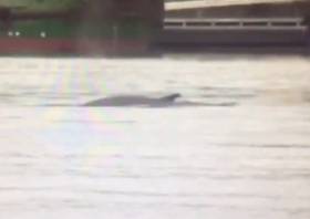
Update Friday 4 October: RTÉ News is now reporting that the whale, now identified as a 25ft fin whale and believed to be a juvenile, was found dead in Dublin Port this morning.

RTÉ News reports on a suspected whale sighting at Dublin Port this afternoon (Wednesday 2 October).

The 20-foot whale, estimated to be some 20 feet in length, was filmed blowing from its blowhole numerous times while swimming near the Stena berth.

Cetaceans rarely make appearances in the city. In November last year a common dolphin brightened a dreary winter’s day for city centre commuters when it swam as far as the Loopline Bridge.

Elsewhere, humpback whales have now been sighted in Donegal Bay, much further north than their usual haunts off the Cork and Kerry coasts.

The Irish Whale and Dolphin Group (IWDG) says records from the 22 and 24 September respectively represent the first for humpbacks in the area since the summer of 2008.

Published in Marine Wildlife
Tagged under

#MarineWildlife - The UK’s Natural History Museum has made available for the first time a vast trove of whale and dolphin stranding records in British and Irish waters.

The data covers the years 1913 to 1989, filling in a significant gap before the Irish Whale and Dolphin Group’s stranding scheme began in 1991.

Over the years many entries were submitted by the coastguard, fishermen and members of the public — including a detailed record of a harbour porpoise found in Co Cork in 1913, the very first card in the data set.

PhD candidate Ellen Coombs is combing through the records to determine what picture “one of the longest systematic cetacean stranding data sets in the world” reveals for the status of cetacean species in our waters.

And already there have been some important finds, such as occasional records of deep-diving Cuvier’s beaked whales over the decades — not to mention a double stranding of narwhals in 1949.

The data also correlates with already known trends, such as the sharp decline in blue whale records with the expansion of commercial whaling in the early 20th century.

The Natural History Museum website has more on the story HERE.

Published in Marine Wildlife

#MarineWildlife - Unusual weather for this time of year may be responsible for a recent spate of whale and dolphin strandings on the Cork coast in the past week.

The Irish Examiner reports that among the eight strandings were the carcass of a sperm whale on Long Strand in West Cork and a dolphin with fishing line around its beak in Schull.

However, the Irish Whale and Dolphin Group’s (IWDG) Mick O’Connell said that while the statistic was high within such a short timeframe, it was not necessarily a mystery.

“We normally get the same thing every year,” said the IWDG stranding officer. “It is usually more in the southwest and west, but this year, I suppose we have had more southeast winds, which probably explains it.”

O’Connell added that the strandings are “only a percentage of what is actually dead at sea” — and that post-mortems may “shed some light in their deaths”.

The Irish Examiner has more on the story HERE.

Published in Marine Wildlife
Page 1 of 8

General Information on using Waterways Ireland inland navigations

Safety on the Water

All users of the navigations are strongly recommended to make themselves aware of safety on the water for whatever activity they are involved in and to read the advice offered by the various governing bodies and by:

The Dept. of Transport, Ireland: www.gov.ie/transport and The Maritime and Coastguard Agency, UK, The RNLI – Water Safety Ireland for information in terms of drowning prevention and water safety.

Registration of Vessels

All vessels using the Shannon Navigation, which includes the Shannon-Erne Waterways and the Erne System must be registered with Waterways Ireland. Only open undecked boats with an engine of 15 horsepower or less on the Shannon Navigation, and vessels of 10 horsepower or less on the Erne System, are exempt. Registration is free of charge.

Craft registration should be completed online at: https://www.waterwaysireland.org/online-services/craft-registration

Permits for use of the Grand and Royal Canals and the Barrow Navigation

All vessels using the Grand and Royal Canals and the Barrow Navigation must display appropriate valid Permit(s) i.e A Combined Mooring and Passage Permit (€126) and if not intending to move every five days, an Extended Mooring Permit (€152).

Permit applications should be completed online at: https://www.waterwaysireland.org/online-services/canal-permits

Passage on the Royal and Grand Canals – Dublin Area

For boat passage through the locks east of Lock 12 into / out of Dublin on either the Royal or Grand Canals, Masters are requested to contact the Waterways Ireland Eastern Regional Office (M-F 9.30am-4.30pm) on tel: +353(0)1 868 0148 or email [email protected] prior to making passage in order to plan the necessary lock-keeping assistance arrangements.

On the Grand Canal a minimum of two days notice prior to the planned passage should be given, masters should note that with the exception of pre-arranged events, a maximum of 2 boats per day will be taken through the locks, travelling either east or west.

Movements in or out of the city will be organised by prior arrangement to take place as a single movement in one day. Boaters will be facilitated to travel the system if their passage is considered to be safe by Waterways Ireland and they have the valid permit(s) for mooring and passage.

Newcomen Lifting Bridge

On the Royal Canal two weeks’ notice of bridge passage (Newcomen Lifting Bridge) is required for the pre-set lift date, and lock assistance will then also be arranged. A minimum of 2 boats is required for a bridge lift to go ahead.

Waterways Ireland Eastern Regional Office (Tel: +353(0)1 868 0148 or [email protected] ) is the point of contact for the bridge lift.

A maximum number of boats passing will be implemented to keep to the times given above for the planned lifts (16 for the Sat / Sun lifts & 8 for the weekday lifts). Priority will be given on a first come first served basis.

On day of lift, boaters and passengers must follow guidance from Waterways Ireland staff about sequence of passage under bridge & through Lock 1, and must remain within signed and designated areas.

Events Held on the Waterways

All organised events taking place on the waterways must have the prior approval of Waterways Ireland. This is a twelve week process and application forms must be accompanied with the appropriate insurance, signed indemnity and risk assessment. The application should be completed on the Waterways Ireland events page at :

https://www.waterwaysireland.org/online-services/event-approval

Time Limits on Mooring in Public Harbours

On the Shannon Navigation and the Shannon-Erne Waterway craft may berth in public harbours for five consecutive days or a total of seven days in any one month.

On the Erne System, revised Bye Laws state that: No master or owner shall permit a vessel, boat or any floating or sunken object to remain moored at or in the vicinity of any public mooring, including mooring at any other public mooring within 3 kilometres of that location, for more than 3 consecutive days and shall not moor at that same mooring or any other public mooring within 3 kilometres of that location within the following 3 consecutive days without prior permission by an authorised official.

Winter Mooring on the Shannon Navigation and Shannon Erne Waterway

Winter mooring may be availed of by owners during the period 1 Nov to 31 Mar by prior arrangement and payment of a charge of €63.50 per craft. Craft not availing of Winter Mooring must continue to comply with the “5 Day Rule”. Winter Mooring applications should be completed online at : https://www.waterwaysireland.org/online-services/winter-moorings-booking

Owners should be aware that electricity supply and water supply to public moorings is disconnected for the winter months. This is to protect against frost damage, to reduce running costs and to minimise maintenance requirements during the winter months.

Vessel owners are advised that advance purchasing of electricity on the power bollards leading up to the disconnection date should be minimal. Electricity credit existing on the bollards will not be recoverable after the winter decommissioning date. Both services will be reinstated prior to the commencement of the next boating season.

Smart Cards

Waterways Ireland smart cards are used to operate locks on the Shannon Erne Waterway, to access the service blocks, to use the pump-outs along the navigations, to avail of electrical power at Waterways Ireland jetties.

Berthing in Public Harbours

Masters are reminded of the following:

  • Equip their vessel with mooring lines of appropriate length and strength and only secure their craft to mooring bollards and cleats provided for this purpose.
  • Ensure the available berth is suitable to the length of your vessel, do not overhang the mooring especially on finger moorings on floating pontoon moorings.
  • Ensure mooring lines, electric cables and fresh water hoses do not create a trip hazard on public jetties for others users.
  • Carry sufficient fenders to prevent damage to your own vessel, other vessels and WI property.
  • Allow sufficient space between your vessel and the vessel ahead /astern (c.1m) for fire safety purposes and /or to recover somebody from the water.
  • Do not berth more than two vessels side by side and ensure there is safe access/egress at all times between vessels and onto the harbour itself.
  • Do not berth in such a way to prevent use of harbour safety ladders, slipways or pump-outs.
  • Do not allow the bow of your vessel to overhang the walkway of a floating mooring thus creating a hazard for others with an overhanging anchor or bow fendering.
  • Animals are not allowed to be loose or stray at any time.
  • Harbour and jetty infrastructure such as railings, power pedestals, fresh water taps, electric light poles, safety bollards, ladders etc are not designed for the purpose of mooring craft , they will not bear the strain of a vessel and will be damaged.
  • At Carrybridge on the Erne System, Masters of vessels are not permitted to use stern on mooring. Masters of vessels must use the mooring fingers for mooring of vessels and for embarkation / disembarkation from vessels.

Passenger Vessel Berths

Masters of vessels should not berth on passenger vessel berths where it is indicated that an arrival is imminent. Passenger vessels plying the navigations generally only occupy the berths to embark and disembark passengers and rarely remain on the berths for extended periods or overnight.

Lock Lead-in Jetties

Lead-in jetties adjacent to the upstream and downstream gates at lock chambers are solely for the purpose of craft waiting to use the lock and should not be used for long term berthing.

Vessel Wake

Vessel wake, that is, the wave generated by the passage of the boat through the water, can sometimes be large, powerful and destructive depending on the hull shape and engine power of the vessel. This wake can be detrimental to other users of the navigation when it strikes their craft or inundates the shoreline or riverbank. Masters are requested to frequently look behind and check the effect of their wake / wash particularly when passing moored vessels, on entering harbours and approaching jetties and to be aware of people pursuing other activities such as fishing on the riverbank.

Speed Restriction

A vessel or boat shall not be navigated on the Shannon Navigation at a speed in excess of 5 kph when within 200 metres of a bridge, quay, jetty or wharf, when in a harbour or canal or when passing within 100 metres of a moored vessel or boat.

Vessels navigating the Shannon-Erne Waterway should observe the general 5 kph speed limit which applies along the waterway. This is necessary in order to prevent damage to the banks caused by excessive wash from vessels.

Vessels navigating the Erne System should observe the statutory 5kt / 6mph / 10kph speed limit areas.

A craft on the Royal and Grand canals shall not be navigated at a speed in excess of 6km per hour.

A craft on the Barrow Navigation shall not be navigated at a speed in excess of 11km per hour except as necessary for safe navigation in conditions of fast flow.

Bank Erosion

Narrow sections of all the navigations are particularly prone to bank erosion due to the large wash generated by some craft. Masters are requested to be vigilant and to slow down to a speed sufficient to maintain steerage when they observe the wash of their craft inundating the river banks.

Unusual Waterborne Activity

Unusual waterborne vessels may be encountered from time to time, such as, hovercraft or amphibious aircraft / seaplanes. Masters of such craft are reminded to apply the normal “Rule of the Road” when they meet conventional craft on the water and to allow extra room to manoeuvre in the interest of safety.

Sailing Activity

Mariners will encounter large numbers of sailing dinghies from late June to August in the vicinity of Lough Derg, Lough Ree and Lower Lough Erne. Sailing courses are marked by yellow buoys to suit weather conditions on the day. Vessels should proceed at slow speed and with due caution and observe the rules of navigation when passing these fleets, as many of the participants are junior sailors under training.

Rowing

Mariners should expect to meet canoes and vessels under oars on any part of the navigations, but more so in the vicinity of Athlone, Carrick-on-Shannon, Coleraine, Enniskillen and Limerick. Masters are reminded to proceed at slow speed and especially to reduce their wash to a minimum when passing these craft as they can be easily upset and swamped due to their very low freeboard and always be prepared to give way in any given traffic situation.

Canoeing

Canoeing is an adventure sport and participants are strongly recommended to seek the advice of the sport’s governing bodies i.e Canoeing Ireland and the Canoe Association of Northern Ireland, before venturing onto the navigations.

Persons in charge of canoes are reminded of the inherent danger to these craft associated with operating close to weirs, sluice gates, locks and other infrastructure particularly when rivers are in flood and large volumes of water are moving through the navigations due to general flood conditions or very heavy localised precipitation e.g. turbulent and broken water, stopper waves. Shooting weirs is prohibited without prior permission of Waterways Ireland.

Canoeists should check with lockkeepers prior entering a lock to ensure passage is done in a safe manner. Portage is required at all unmanned locks.

Canoe Trail Network – "Blueways"

Masters of powered craft are reminded that a canoe trail network is being developed across all navigations and to expect more organised canoeing along these trails necessitating slow speed and minimum wash when encountering canoeists, rowing boats etc

Rockingham and Drummans Island Canals – Lough Key

It is expected that work on Rockingham and Drummans Island Canals on Lough Key will be completed in 2021. Access to these canals will be for non-powered craft only, eg canoes, kayaks, rowing boats.

Fast Powerboats and Personal Watercraft (Jet Skis)

Masters of Fast Powerboats (speed greater than 17kts) and Personal Watercraft (i.e.Jet Skis) are reminded of the inherent dangers associated with high speed on the water and especially in the confines of small bays and narrow sections of the navigations. Keeping a proper look-out, making early alterations to course and /or reducing speed will avoid conflict with slower vessels using the navigation. Personal Watercraft are not permitted to be used on the canals.

Towing Waterskiers, Wakeboarders, Doughnuts etc

Masters of vessels engaged in any of these activities are reminded of the manoeuvring constraints imposed upon their vessel by the tow and of the added responsibilities that they have to the person(s) being towed. These activities should be conducted in areas which are clear of conflicting traffic. It is highly recommended that a person additional to the master be carried to act as a “look-out” to keep the tow under observation at all times.

Prohibition on Swimming

Swimming in the navigable channel, particularly at bridges, is dangerous and is prohibited due to the risk of being run over by a vessel underway in the navigation.

Age Restrictions on operating of powered craft

In the Republic of Ireland, Statutory Instrument 921 of 2005 provides the legal requirements regarding the minimum age for operating of powered craft. The Statutory Instrument contains the following requirements:

- The master or owner of a personal watercraft or a fast power craft shall take all reasonable steps to ensure that a person who has not attained the age of 16 years does not operate or control the craft

- The master or owner of a pleasure craft powered by an engine with a rating of more than 5 horse power or 3.7 kilowatts shall take all reasonable steps to ensure that a person who has not attained the age of 12 years does not operate or control the craft.

Lifejackets and Personal Flotation Devices (PFDs)

Lifejackets and PFD’s are the single most important items of personal protective equipment to be used on a vessel and should be worn especially when the vessel is being manoeuvred such as entering / departing a lock, anchoring, coming alongside or departing a jetty or quayside.

In the Republic of Ireland, Statutory Instrument 921 of 2005 provides the legal requirements regarding the wearing of Personal Flotation Devices. The Statutory Instrument contains the following requirements:

- The master or owner of a pleasure craft (other than a personal watercraft) shall ensure, that there are, at all times on board the craft, sufficient suitable personal flotation devices for each person on board.

- A person on a pleasure craft (other than a personal watercraft) of less than 7 metres length overall shall wear a suitable personal flotation device while on board an open craft or while on the deck of decked craft, other than when the craft is made fast to the shore or at anchor.

- The master or owner of a pleasure craft (other than a personal watercraft) shall take all reasonable steps to ensure that a person who has not attained the age of 16 years complies with paragraph above.

- The master or owner of a pleasure craft (other than a personal watercraft), shall take all reasonable steps to ensure that a person who has not attained the age of 16 years wears a suitable personal flotation device while on board an open craft or while on the deck of a decked craft other than when it is made fast to the shore or at anchor.

- The master or owner of a pleasure craft (other than a personal watercraft) shall take all reasonable steps to ensure that a person wears a suitable personal flotation device, at all times while – (a) being towed by the craft, (b) on board a vessel or object of any kind which is being towed by the craft.

Further information is available at: http://www.irishstatutebook.ie/eli/2005/si/921/made/en/print

Firing Range Danger Area – Lough Ree

The attention of mariners is drawn to the Irish Defence Forces Firing Range situated in the vicinity of buoys No’s 2 and 3, on Lough Ree on the Shannon Navigation. This range is used regularly for live firing exercises, throughout the year, all boats and vessels should stay clear of the area marked with yellow buoys showing a yellow "X" topmark and displaying the word "Danger".

Shannon Navigation, Portumna Swing Bridge Tolls

No attempt should be made by Masters’ of vessels to pay the bridge toll while making way through the bridge opening. Payment will only be taken by the Collector from Masters when they are secured alongside the jetties north and south of the bridge.

Navigating from Killaloe to Limerick on the Shannon Navigation

The navigation from Killaloe to Limerick involves passage through Ardnacrusha locks, the associated headrace and tailrace and the Abbey River into Limerick City. Careful passage planning is required to undertake this voyage. Considerations include: lock passage at Ardnacrusha, water flow in the navigation, airdraft under bridges on Abbey River in Limerick, state of tide in Limerick

Users are advised to contact the ESB Ardnacrusha hydroelectric power station (00353 (0)87 9970131) 48 hours in advance of commencing their journey to book passage through the locks at Ardnacrusha. It is NOT advised to undertake a voyage if more than one turbine is operating (20MW), due to the increased velocity of flow in the navigation channel, which can be dangerous. To ascertain automatically in real time how many turbines are running, users can phone +353 (0)87 6477229.

For safety reasons the ESB has advised that only powered craft with a capacity in excess of 5 knots are allowed to enter Ardnacrusha Headrace and Tailrace Canals.

Passage through Sarsfield Lock should be booked on +353-87-7972998, on the day prior to travel and it should be noted also that transit is not possible two hours either side of low water.

A Hydrographic survey in 2020 of the navigation channel revealed that the approach from Shannon Bridge to Sarsfield Lock and the Dock area has silted up. Masters of vessels and water users are advised to navigate to the Lock from Shannon bridge on a rising tide one or two hours before High Tide.

Lower Bann Navigation

The attention of all users is drawn to the “Users Code for the Lower Bann”, in particular to that section covering “Flow in the River” outlining the dangers for users both on the banks and in the navigation, associated with high flow rates when the river is in spate. Canoeists should consult and carry a copy of the “Lower Bann Canoe Trail” guide issued by the Canoe Association of Northern Ireland. Users should also contact the DfI Rivers Coleraine, who is responsible for regulating the flow rates on the river, for advisory information on the flow rates to be expected on any given day.

DfI Rivers Coleraine. Tel: 0044 28 7034 2357 Email: [email protected]

Lower Bann Navigation – Newferry – No wake zone

A No Wake Zone exists on the Lower Bann Navigation at Newferry. Masters of vessels are requested to proceed at a slow speed and create no wake while passing the jetties and slipways at Newferry.

Overhead Power Lines (OHPL) and Air draft

All Masters must be aware of the dangers associated with overhead power lines, in particular sailing vessels and workboats with cranes or large air drafts. Voyage planning is a necessity in order to identify the location of overhead lines crossing the navigation.

Overhead power line heights on the River Shannon are maintained at 12.6metres (40 feet) from Normal Summer level for that section of navigation, masters of vessels with a large air draft should proceed with caution and make additional allowances when water levels are high.

If a vessel or its equipment comes into contact with an OHPL the operator should NOT attempt to move the vessel or equipment. The conductor may still be alive or re-energise automatically. Maintain a safe distance and prevent third parties from approaching due to risk of arcing. Contact the emergency services for assistance.

Anglers are also reminded that a minimum ground distance of 30 metres should be maintained from overhead power lines when using a rod and line.

Submarine Cables and Pipes

Masters of vessels are reminded not to anchor their vessels in the vicinity of submarine cables or pipes in case they foul their anchor or damage the cables or pipes. Look to the river banks for signage indicating their presence.

Water Levels - Precautions

Low Water Levels:

When water levels fall below normal summer levels masters should be aware of:

Navigation

To reduce the risk of grounding masters should navigate on or near the centreline of the channel, avoid short cutting in dog-legged channels and navigating too close to navigation markers.

Proceeding at a slow speed will also reduce “squat” effect i.e. where the vessel tends to sit lower in the water as a consequence of higher speed.

Slipways

Reduced slipway length available under the water surface and the possibility of launching trailers dropping off the end of the concrete apron.

More slipway surface susceptible to weed growth requiring care while engaged in launching boats, from slipping and sliding on the slope. Note also that launching vehicles may not be able to get sufficient traction on the slipway once the craft is launched to get up the incline.

Bank Erosion

Very dry riverbanks are more susceptible to erosion from vessel wash.

Lock Share

Maximising on the number of vessels in a lock will ensure that the total volume of water moving downstream is decreased. Lock cycles should be used for vessels travelling each way.

High Water Levels:

When water levels rise above normal summer level masters should be aware of:

Navigation

Navigation marks will have reduced height above the water level or may disappear underwater altogether making the navigable channel difficult to discern.

In narrow sections of the navigations water levels will tend to rise more quickly than in main streams and air draft at bridges will likewise be reduced.

There will also be increased flow rates particularly in the vicinity of navigation infrastructure such as bridges, weirs, locks etc where extra care in manoeuvring vessels will be required.

Harbours and Jetties

Due care is required in harbours and at slipways when levels are at or near the same level as the harbour walkways' as the edge will be difficult to discern especially in reduced light conditions. It is advised that Personal Flotation Devices be worn if tending to craft in a harbour in these conditions.

Slipways

Slipways should only be used for the purpose of launching and recovering of water craft or other objects from the water. Before using a slipway it should be examined to ensure that the surface has sufficient traction/grip for the intended purpose such as launching a craft from a trailer using a vehicle, that there is sufficient depth of water on the slipway to float the craft off the trailer before the concrete apron ends and that the wheels of the trailer do not drop off the edge of the slipway. That life-saving appliances are available in the vicinity, that the vehicle is roadworthy and capable of coping with the weight of the trailer and boat on the incline. It is recommended that slipway operations are conducted by two persons.

Caution to be Used in Reliance upon Aids to Navigation

The aids to navigation depicted on the navigation guides comprise a system of fixed and floating aids to navigation. Prudent mariners will not rely solely on any single aid to navigation, particularly a floating aid to navigation. With respect to buoys, the buoy symbol is used to indicate the approximate position of the buoy body and the ground tackle which secures it to the lake or river bed. The approximate position is used because of the practical limitations in positioning and maintaining buoys in precise geographical locations. These limitations include, but are not limited to, prevailing atmospheric and lake/river conditions, the slope of and the material making up the lake/river bed, the fact that the buoys are moored to varying lengths of chain, and the fact that the buoy body and/or ground tackle positions are not under continuous surveillance. Due to the forces of nature, the position of the buoy body can be expected to shift inside and outside the charted symbol.

Buoys and perches are also moved out of position or pulled over by those mariners who use them to moor up to instead of anchoring. To this end, mariners should always monitor their passage by relating buoy/perch positions with the published navigation guide. Furthermore, a vessel attempting to pass close by always risks collision with a yawing buoy or with the obstruction that the buoy or beacon/perch marks.

Masters of Vessels are requested to use the most up to date Navigation guides when navigating on the Inland Waterways.

Information taken from Special Marine Notice No 1 of 2023