Menu

Ireland's sailing, boating & maritime magazine

Inland afloat headers


Displaying items by tag: coliemore harbour

Ringsend residents lined the streets of the south Dublin village to pay respects to the late Ken Cunningham following his funeral Mass on Saturday (3 February).

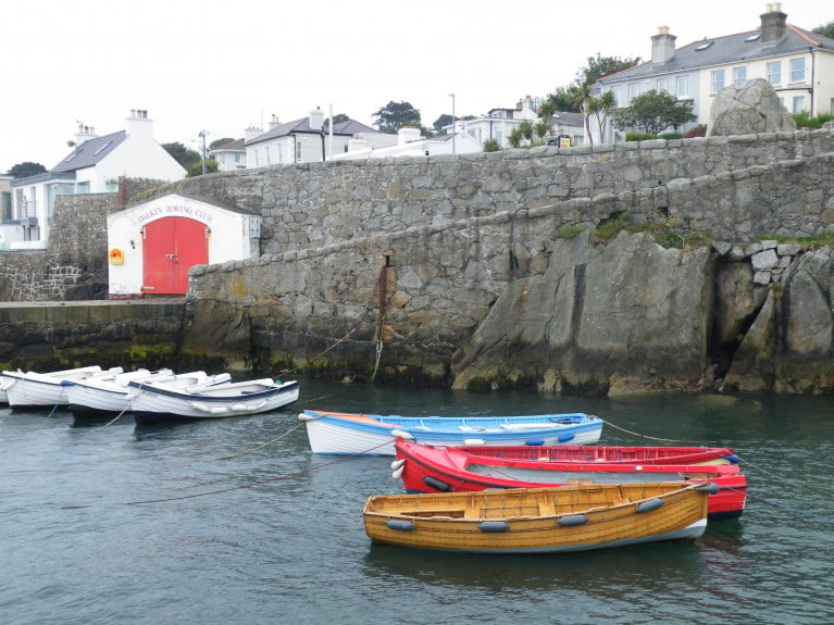
For many years Ken ran the passenger ferry, Licence No 1877, from Coliemore Harbour to Dalkey Island and made such an impact on the local community that Coliemore became affectionately known as “Ken’s Harbour”.

Ken was also an accomplished rower — unsurprising as he was one of the storied Cunninghams of Dalkey and East Coast rowing renown — and was a member of both Dalkey Rowing Club and St Patrick’s Rowing Club in Ringsend, which was his home in later years and where he leaves a lasting legacy.

Among those paying tribute on social media were Dakley Tidy Towns, who described Ken as “fund of knowledge and information on our surrounding waters”.

Members of St Patrick’s Rowing Club form a guard of honour outside St Patrick’s Church in Ringsend at the funeral Mass for Ken Cunningham on Saturday 3 FebruaryMembers of St Patrick’s Rowing Club form a guard of honour outside St Patrick’s Church in Ringsend at the funeral Mass for Ken Cunningham on Saturday 3 February

Published in Dublin Bay

Engineering works which took place over recent months in Dalkey, Co. Dublin involving the Coliemore Harbour Remedial Repair project have been completed this week, writes Jehan Ashmore.

A section of bedrock along the cliff face as Afloat reported in 2020, had collapsed into the water at the stone cut harbour which in medieval times was the port of Dublin. The small harbour is home to local boat users, a seasonal ferry boat service to Dalkey Island and the Dalkey Rowing Club.

The section of bedrock had been supporting the pathway leading to the southern pier which resulted in this part of the harbour to be temporarily closed. Prior to the engineering works starting in September, the ferry-boat service to Dalkey Island was able to operate this season operated by ‘Ken the Ferryman’ using the 12 passenger boat, Emma.

Afloat sought a comment on the project from Dun Laoghaire-Rathdown County Council (dlr) which are delighted to have completed the Coliemore Harbour Remedial Repair project. 

A series of remedial options were considered and that planning permission was subsequently granted for the installation of a series of rock bolts anchored into the granite bedrock.

The completed engineering works at Coliemore Harbour where rock-bolts have been anchored into the face of the bedrock, this permits access to the south pier via a pathway and above a public viewing area that has also been recently reopened.    Photo: DunLaoghaireRathdownCountyCouncil/FacebookThe completed engineering works at Coliemore Harbour where rock-bolts have been anchored into the face of the bedrock, this permits access to the south pier via a pathway and above a public viewing area that has also been recently reopened Photo: DunLaoghaireRathdownCountyCouncil/Facebook

The coastal engineering works, Afloat adds required the use of a crane to lower personnel to carry out works along the bedrock, noting the varying tidal conditions of the harbour. The large piece of dislodged bedrock that had fallen into the harbour was subsequently removed and is where a boom still remains in place. 

The DLR have expressed thanks to their staff across departments for their invaluable contribution in delivering the scheme. In addition to Ove Arup, the lead consultant, and PJ Edwards as the main Contractor in successfully delivering the project in an environmentally constrained marine environment.

DLR also thank local stakeholders and users of the harbour for their support and accommodation in delivering the project. 

The harbour project Afloat adds was co-funded by the Department of Agriculture, Food and the Marine, under the Fishery Harbour and Coastal Infrastructure Development Programme.

On completion of the project, this has also led to the reopening of the public plaza viewing area that overlooks the harbour on Coliemore Road.

Also sited here is a binocular-scope, donated by Dalkey Tidy Towns along with a plaque in memory and celebration of the late Dr. John de Courcy Ireland, the maritime historian who resided locally and is widely regarded as the father of ‘maritime’ Ireland.

Published in Dublin Bay

Dún Laoghaire-Rathdown County Council has applied to An Bord Pleanála to carry out remedial works for a pier walkway in Coliemore Harbour which is a Protected Structure, located in Dalkey, on the southern shore of Dublin Bay.

The proposed development will comprise the mobilisation and site set-up, including access to a viewing platform and obstruction removal (bollards etc); removal of the temporary walkway to allow access for grouting. 

The works include the installation of up to 16 rock anchors from the suspended platform via a crane located on the viewing platform and a resurfacing of the existing walkway.

As Afloat reported previously, €75,000 of funding was received for Coliemore Harbour repairs in 2021. 

More on the DLRCoCo application is here

Published in Dublin Bay

A Dun Laoghaire Senator has described this week's €35m Brexit Infrastructure Fund as an 'opportunity' for improvement of crumbling Dublin Bay Harbours.

Senator Barry Ward tweeted that both Coliemore and Bulloch Harbours in Dalkey County Dublin and Dun Laoghaire Harbour were all in need of 'urgent attention' in different ways.

Marine Minister Charlie McConalogue T.D., announced on Monday the new scheme to rejuvenate local authority public piers and harbours throughout coastal communities.

Afloat previously reported in 2020 how the popular Dalkey Island seasonal ferryboat stopped service due to a partial collapse of a cliff-face underneath a footpath leading to the pier at Coliemore Harbour, Co. Dublin

And in 2018, Bulloch Harbour's Bicencentary was against a backdrop of Storm Damage suffered in Storm Emma.

Senator Barry WardSenator Barry Ward

Announcing the scheme, the Minister said this week “This record funding for our coastal communities is an unprecedented opportunity for us to invest in our publicly owned piers and harbours and will shape the future of our coastal communities. Brexit has and will continue to affect our seafood sector in a unique way compared to other industries. I am delighted to be able to offer this level of investment so that we can deliver safe, accessible, lasting infrastructure and support economic diversification right around our coastline.”

Published in Dublin Bay

Dublin harbours are set to receive over €8.4m in funding for harbours in Fingal (Loughshinny Harbour, Skerries and Balbriggan Harbours) with Howth Harbour receiving €8.2m for specific improvements and two harbours in Dún Laoghaire-Rathdown County Council (Dún Laoghaire Harbour and Coliemore).

As Afloat reported earlier, the allocation of €38.3 million by Minister for the Marine, Charlie McConalogue TD is to repair, maintain and upgrade Ireland's publicly owned harbour network has been warmly welcomed.

Welcoming the announcement, Fianna Fáil Dublin Spokesperson Cormac Devlin TD (Dún Laoghaire) noted that funding of €75,000 for Coliemore Harbour in Dalkey and an allocation of €63,750 to install a pontoon in the Coal Harbour and upgrade facilities for local fishermen at Trader's Wharf in Dún Laoghaire Harbour were especially welcome.

Commenting, Deputy Devlin said "Coliemore Harbour is one of Ireland's oldest harbours dating back to the 13th century, when it was the leading port on the East Coast. The harbour has been in continuous use for hundreds of years, but was damaged by a rockfall in August 2020 and has been partially closed since. This funding will enable Dún Laoghaire - Rathdown County Council to carry out the estimated €100,000 works to repair and reopen the harbour."

Local Fianna Fáil councillor for Dalkey Justin Moylan commented "I am extremely grateful to my Party colleagues; Minister Charlie McConalogue and Deputy Cormac Devlin for their support for this important funding. Unfortunately having part of our harbour closed hampered the activities of local boatman, Ken The Ferryman as well as our award-winning Dalkey Rowing Club. Hopefully now with this funding they can all resume their activities for summer 2021"

The funding formed part of overall funding of €38.3m announced by Minister McConalogue who said, “This capital investment package in our 79 Local Authority owned piers and harbours around our coast which underlines the importance this Government places on the contribution of the wider seafood sector to Ireland’s economy and to rural coastal communities in particular.”

The Local Authority programme forms part of the Department of Agriculture, Food and the Marines’ 2021 Fishery Harbour and Coastal Infrastructure Development Programme, whereby the Department co-funds up to 75% of the total cost of approved projects with the Local Authority providing the balance.

In regard to the Local Authority scheme, the Minister stated, “It was important to me to place added importance on the Local Authority scheme this year and I am pleased to be to in a position to announce an enhanced €4.2 million programme in 2021 to assist Coastal Local Authorities in the repair and development of fishery and aquaculture linked marine infrastructures under their ownership. This year I have redirected savings due to Covid limitations on other projects to increase the monies available to the Local Authorities resulting in a 35% increase in 2020 allocations. Together with funding from Local Authorities, the total amount to be invested in local piers and harbours in 2021 under this scheme comes to €5.6 million.”

Published in Dublin Bay

The popular Dalkey Island seasonal ferryboat has stopped service due to a partial collapse of a cliff-face underneath a footpath leading to the pier at Coliemore Harbour, Co. Dublin, writes Jehan Ashmore.

The ferry operator, Ken Cunningham said "unfortunately due to an incident in the harbour I cannot operate the ferry this weekend, its under investigation right now with DLRCoCo because part of the wall fell out where the walkway is and it is unsafe for anyone too walk down"

He added "I'm sorry for any inconvenience caused to anyone who was planning a trip over to the island this weekend. Hopefully, I won't be out of action for too long".

Directly below the footpath wall that provides access from Coliemore Road, is where the jagged chunk of cliff-face sheared off below into the harbour which during medieval times acted as the Port of Dublin. The only commercial operation using the beautiful stone-cut harbour now is the 'Ken The Ferryman' service until this week's rock-fall incident (see: facebook's close up photo).

A close up of the affected cliff-face at Coliemore HarbourA close up of the affected cliff-face at Coliemore Harbour

The stretch of water across Dalkey Sound is a mere 300m between the mainland harbour and the landing slipway on the island which together in 2014 were upgraded by Dun Laoghaire-Rathdown County Council (DLRCoCo). For more details of these works (see p.23) of 'Maritime' Dalkey coverage in the Dalkey Community Council newsletters, also features the resumption of the ferry service after three years absence.  

Due to Covid-19 restrictions the service was delayed from beginning earlier this season using instead of the Lilly Rose a new larger replacement passenger boat, Gemma but now currently off-service due to cliff rock-fall.

The ferryboat service at Coliemore Harbour is located less than a mile from Dalkey which is a designated 'Heritage Town' with its scenic coastline along the Dublin Riviera.

It is also along the harbour's footpath wall where local youths have been gathering and jumping off directly into the water below, however the fallen rock is now in this same area posing a danger to such activity. In addition the rock is a danger to nearby timber and fibreglass built moored boats.

DLRCoCo has blocked of Coliemore Harbour's walkway leading to the ferry pier with signs stating no unauthorised access and danger warnings of 'falling rocks' and 'closed due to repair works needed'. Access remains open but only to the slip and adjoining second pier with anglers given the mackeral season is underway.

The stretch of water between Coliemore and the island is named Dalkey Sound which is a mere 300m wide and is linked by the traditional ferryboat service.

In addition the affected walkway has also led to no access to Dalkey Rowing Club's premises and so coastal rowing of 'skiff' boats have been cancelled. 

Ken the Ferryman is the sole operator providing exclusively the Department of Marine inspected and licensed passenger-boat service off the south Dublin suburb which has become more famous as it is host to the annual Dalkey Book Festival. This year's 10th festival, however was postponed due to Covid-19 public health restrictions.

Published in Dublin Bay

#dunlaoghairelifeboat – Both RNLI lifeboats at Dun Laoghaire on Dublin Bay were called out yesterday afternoon following a 999 emergency call that a two-person canoe was drifting close to shore off Dalkey.

The Irish Coast Rescue 116 helicopter at Dublin Airport and Dun Laoghaire Coast Guard Unit were also tasked due to concern for the occupants of the craft.

The incident occurred at around 1.15pm but was stood down 15 minutes later when the two canoeists were located safe and well with friends by the CG shore team at Coliemore Harbour in Dalkey.

The ILB recovered the canoe and returned it to them before returning to station.

Published in RNLI Lifeboats

The south and west coasts endured another day of damage due to harsh weather and the east coast remained relatively unscathed. The high tides on Dublin Bay last night however showed just how vulnerable some of the capital's old harbours might be if the gales had been from the east rather than the west. This vid from reader Ronan Beirne shows the situation at Coliemore harbour in Dalkey at high water yesterday afternoon.

Winter storms are nothing new but to be battered by them repeatedly over a short period as Ireland and the Britain have been in recent days may become more frequent due to climate change according to analysis in today's Irish Times by Environment editor, Frank McDonald. More here.

Published in Dublin Bay

#Begnet'sBoats – A community-led project to build a pair of currachs in Dalkey, Co. Dublin is gaining momentum as locals participate in a goal to launch the boats from Coliemore Habour on 1 June, writes Jehan Ashmore.

The Begnet's Boats Project is the vision of local resident Liz Murray who was inspired to bring the community together in a creative approach and to reflect the rich maritime heritage of Dalkey and local saint of St. Begnet. There are two churches in her name, one located in the town and the other on the small island lying some 300m offshore.

Murray has assigned a team to construct the pair of 'racing' currachs and they are to be led by boat-builder Mark Reddon. In addition the community are invited to take part in accompanying projects, one in which includes a 'St. Begnet's Cookbook' which features seafaring recipes by Elaine Flood.

The highlight of the venture will be a parade of the boats which are to be carried upside down, as is the traditional manner, from Castle Street, the town's main street to the coast at Coliemore Harbour.

From there the currachs, to be named 'Naomh Beagnait 1 & 2' will ceremoniously be rowed if not raced! across Dalkey Sound to the island, where the first reference to St. Begnet on the island dates to 700 A.D.

Information in how to get involved including a reward scheme and fundraiser countdown campaign can be viewed by visiting: www.fundit.ie/project/begnets-boats-project-2013

It would seem that the only way to get to Dalkey Island these days is by privately-owned craft and as previously reported on Afloat.ie, Coliemore Harbour has not had access to a ferry boat service in recent years. The harbour has been the traditional embarkation point for generations.

Currently engineering consultants are carrying out a structural survey and report due to be completed around May. The consultants were contracted by Dun Laoghaire-Rathdown County Council who had deemed the harbour unsafe and not suitable for use by a commercial ferry operator.

The delay in restoring a licensed ferry service has led to a campaign by locals, businesses and community groups who have feared that an alternative longer term ferry service would operate instead from either Bulloch or Dun Laoghaire Harbour.

Published in Currachs

#Dalkey's Coliemore Harbour on the Dublin coast succumbed for a time to today's North easterly gales with large waves breaking over the ancient harbour walls at high water (and big waves in Dalkey Sound too) as the above video from Ronan Beirne at Lenister Boats shows.

Published in Dublin Bay
Tagged under
Page 1 of 2

General Information on using Waterways Ireland inland navigations

Safety on the Water

All users of the navigations are strongly recommended to make themselves aware of safety on the water for whatever activity they are involved in and to read the advice offered by the various governing bodies and by:

The Dept. of Transport, Ireland: www.gov.ie/transport and The Maritime and Coastguard Agency, UK, The RNLI – Water Safety Ireland for information in terms of drowning prevention and water safety.

Registration of Vessels

All vessels using the Shannon Navigation, which includes the Shannon-Erne Waterways and the Erne System must be registered with Waterways Ireland. Only open undecked boats with an engine of 15 horsepower or less on the Shannon Navigation, and vessels of 10 horsepower or less on the Erne System, are exempt. Registration is free of charge.

Craft registration should be completed online at: https://www.waterwaysireland.org/online-services/craft-registration

Permits for use of the Grand and Royal Canals and the Barrow Navigation

All vessels using the Grand and Royal Canals and the Barrow Navigation must display appropriate valid Permit(s) i.e A Combined Mooring and Passage Permit (€126) and if not intending to move every five days, an Extended Mooring Permit (€152).

Permit applications should be completed online at: https://www.waterwaysireland.org/online-services/canal-permits

Passage on the Royal and Grand Canals – Dublin Area

For boat passage through the locks east of Lock 12 into / out of Dublin on either the Royal or Grand Canals, Masters are requested to contact the Waterways Ireland Eastern Regional Office (M-F 9.30am-4.30pm) on tel: +353(0)1 868 0148 or email [email protected] prior to making passage in order to plan the necessary lock-keeping assistance arrangements.

On the Grand Canal a minimum of two days notice prior to the planned passage should be given, masters should note that with the exception of pre-arranged events, a maximum of 2 boats per day will be taken through the locks, travelling either east or west.

Movements in or out of the city will be organised by prior arrangement to take place as a single movement in one day. Boaters will be facilitated to travel the system if their passage is considered to be safe by Waterways Ireland and they have the valid permit(s) for mooring and passage.

Newcomen Lifting Bridge

On the Royal Canal two weeks’ notice of bridge passage (Newcomen Lifting Bridge) is required for the pre-set lift date, and lock assistance will then also be arranged. A minimum of 2 boats is required for a bridge lift to go ahead.

Waterways Ireland Eastern Regional Office (Tel: +353(0)1 868 0148 or [email protected] ) is the point of contact for the bridge lift.

A maximum number of boats passing will be implemented to keep to the times given above for the planned lifts (16 for the Sat / Sun lifts & 8 for the weekday lifts). Priority will be given on a first come first served basis.

On day of lift, boaters and passengers must follow guidance from Waterways Ireland staff about sequence of passage under bridge & through Lock 1, and must remain within signed and designated areas.

Events Held on the Waterways

All organised events taking place on the waterways must have the prior approval of Waterways Ireland. This is a twelve week process and application forms must be accompanied with the appropriate insurance, signed indemnity and risk assessment. The application should be completed on the Waterways Ireland events page at :

https://www.waterwaysireland.org/online-services/event-approval

Time Limits on Mooring in Public Harbours

On the Shannon Navigation and the Shannon-Erne Waterway craft may berth in public harbours for five consecutive days or a total of seven days in any one month.

On the Erne System, revised Bye Laws state that: No master or owner shall permit a vessel, boat or any floating or sunken object to remain moored at or in the vicinity of any public mooring, including mooring at any other public mooring within 3 kilometres of that location, for more than 3 consecutive days and shall not moor at that same mooring or any other public mooring within 3 kilometres of that location within the following 3 consecutive days without prior permission by an authorised official.

Winter Mooring on the Shannon Navigation and Shannon Erne Waterway

Winter mooring may be availed of by owners during the period 1 Nov to 31 Mar by prior arrangement and payment of a charge of €63.50 per craft. Craft not availing of Winter Mooring must continue to comply with the “5 Day Rule”. Winter Mooring applications should be completed online at : https://www.waterwaysireland.org/online-services/winter-moorings-booking

Owners should be aware that electricity supply and water supply to public moorings is disconnected for the winter months. This is to protect against frost damage, to reduce running costs and to minimise maintenance requirements during the winter months.

Vessel owners are advised that advance purchasing of electricity on the power bollards leading up to the disconnection date should be minimal. Electricity credit existing on the bollards will not be recoverable after the winter decommissioning date. Both services will be reinstated prior to the commencement of the next boating season.

Smart Cards

Waterways Ireland smart cards are used to operate locks on the Shannon Erne Waterway, to access the service blocks, to use the pump-outs along the navigations, to avail of electrical power at Waterways Ireland jetties.

Berthing in Public Harbours

Masters are reminded of the following:

  • Equip their vessel with mooring lines of appropriate length and strength and only secure their craft to mooring bollards and cleats provided for this purpose.
  • Ensure the available berth is suitable to the length of your vessel, do not overhang the mooring especially on finger moorings on floating pontoon moorings.
  • Ensure mooring lines, electric cables and fresh water hoses do not create a trip hazard on public jetties for others users.
  • Carry sufficient fenders to prevent damage to your own vessel, other vessels and WI property.
  • Allow sufficient space between your vessel and the vessel ahead /astern (c.1m) for fire safety purposes and /or to recover somebody from the water.
  • Do not berth more than two vessels side by side and ensure there is safe access/egress at all times between vessels and onto the harbour itself.
  • Do not berth in such a way to prevent use of harbour safety ladders, slipways or pump-outs.
  • Do not allow the bow of your vessel to overhang the walkway of a floating mooring thus creating a hazard for others with an overhanging anchor or bow fendering.
  • Animals are not allowed to be loose or stray at any time.
  • Harbour and jetty infrastructure such as railings, power pedestals, fresh water taps, electric light poles, safety bollards, ladders etc are not designed for the purpose of mooring craft , they will not bear the strain of a vessel and will be damaged.
  • At Carrybridge on the Erne System, Masters of vessels are not permitted to use stern on mooring. Masters of vessels must use the mooring fingers for mooring of vessels and for embarkation / disembarkation from vessels.

Passenger Vessel Berths

Masters of vessels should not berth on passenger vessel berths where it is indicated that an arrival is imminent. Passenger vessels plying the navigations generally only occupy the berths to embark and disembark passengers and rarely remain on the berths for extended periods or overnight.

Lock Lead-in Jetties

Lead-in jetties adjacent to the upstream and downstream gates at lock chambers are solely for the purpose of craft waiting to use the lock and should not be used for long term berthing.

Vessel Wake

Vessel wake, that is, the wave generated by the passage of the boat through the water, can sometimes be large, powerful and destructive depending on the hull shape and engine power of the vessel. This wake can be detrimental to other users of the navigation when it strikes their craft or inundates the shoreline or riverbank. Masters are requested to frequently look behind and check the effect of their wake / wash particularly when passing moored vessels, on entering harbours and approaching jetties and to be aware of people pursuing other activities such as fishing on the riverbank.

Speed Restriction

A vessel or boat shall not be navigated on the Shannon Navigation at a speed in excess of 5 kph when within 200 metres of a bridge, quay, jetty or wharf, when in a harbour or canal or when passing within 100 metres of a moored vessel or boat.

Vessels navigating the Shannon-Erne Waterway should observe the general 5 kph speed limit which applies along the waterway. This is necessary in order to prevent damage to the banks caused by excessive wash from vessels.

Vessels navigating the Erne System should observe the statutory 5kt / 6mph / 10kph speed limit areas.

A craft on the Royal and Grand canals shall not be navigated at a speed in excess of 6km per hour.

A craft on the Barrow Navigation shall not be navigated at a speed in excess of 11km per hour except as necessary for safe navigation in conditions of fast flow.

Bank Erosion

Narrow sections of all the navigations are particularly prone to bank erosion due to the large wash generated by some craft. Masters are requested to be vigilant and to slow down to a speed sufficient to maintain steerage when they observe the wash of their craft inundating the river banks.

Unusual Waterborne Activity

Unusual waterborne vessels may be encountered from time to time, such as, hovercraft or amphibious aircraft / seaplanes. Masters of such craft are reminded to apply the normal “Rule of the Road” when they meet conventional craft on the water and to allow extra room to manoeuvre in the interest of safety.

Sailing Activity

Mariners will encounter large numbers of sailing dinghies from late June to August in the vicinity of Lough Derg, Lough Ree and Lower Lough Erne. Sailing courses are marked by yellow buoys to suit weather conditions on the day. Vessels should proceed at slow speed and with due caution and observe the rules of navigation when passing these fleets, as many of the participants are junior sailors under training.

Rowing

Mariners should expect to meet canoes and vessels under oars on any part of the navigations, but more so in the vicinity of Athlone, Carrick-on-Shannon, Coleraine, Enniskillen and Limerick. Masters are reminded to proceed at slow speed and especially to reduce their wash to a minimum when passing these craft as they can be easily upset and swamped due to their very low freeboard and always be prepared to give way in any given traffic situation.

Canoeing

Canoeing is an adventure sport and participants are strongly recommended to seek the advice of the sport’s governing bodies i.e Canoeing Ireland and the Canoe Association of Northern Ireland, before venturing onto the navigations.

Persons in charge of canoes are reminded of the inherent danger to these craft associated with operating close to weirs, sluice gates, locks and other infrastructure particularly when rivers are in flood and large volumes of water are moving through the navigations due to general flood conditions or very heavy localised precipitation e.g. turbulent and broken water, stopper waves. Shooting weirs is prohibited without prior permission of Waterways Ireland.

Canoeists should check with lockkeepers prior entering a lock to ensure passage is done in a safe manner. Portage is required at all unmanned locks.

Canoe Trail Network – "Blueways"

Masters of powered craft are reminded that a canoe trail network is being developed across all navigations and to expect more organised canoeing along these trails necessitating slow speed and minimum wash when encountering canoeists, rowing boats etc

Rockingham and Drummans Island Canals – Lough Key

It is expected that work on Rockingham and Drummans Island Canals on Lough Key will be completed in 2021. Access to these canals will be for non-powered craft only, eg canoes, kayaks, rowing boats.

Fast Powerboats and Personal Watercraft (Jet Skis)

Masters of Fast Powerboats (speed greater than 17kts) and Personal Watercraft (i.e.Jet Skis) are reminded of the inherent dangers associated with high speed on the water and especially in the confines of small bays and narrow sections of the navigations. Keeping a proper look-out, making early alterations to course and /or reducing speed will avoid conflict with slower vessels using the navigation. Personal Watercraft are not permitted to be used on the canals.

Towing Waterskiers, Wakeboarders, Doughnuts etc

Masters of vessels engaged in any of these activities are reminded of the manoeuvring constraints imposed upon their vessel by the tow and of the added responsibilities that they have to the person(s) being towed. These activities should be conducted in areas which are clear of conflicting traffic. It is highly recommended that a person additional to the master be carried to act as a “look-out” to keep the tow under observation at all times.

Prohibition on Swimming

Swimming in the navigable channel, particularly at bridges, is dangerous and is prohibited due to the risk of being run over by a vessel underway in the navigation.

Age Restrictions on operating of powered craft

In the Republic of Ireland, Statutory Instrument 921 of 2005 provides the legal requirements regarding the minimum age for operating of powered craft. The Statutory Instrument contains the following requirements:

- The master or owner of a personal watercraft or a fast power craft shall take all reasonable steps to ensure that a person who has not attained the age of 16 years does not operate or control the craft

- The master or owner of a pleasure craft powered by an engine with a rating of more than 5 horse power or 3.7 kilowatts shall take all reasonable steps to ensure that a person who has not attained the age of 12 years does not operate or control the craft.

Lifejackets and Personal Flotation Devices (PFDs)

Lifejackets and PFD’s are the single most important items of personal protective equipment to be used on a vessel and should be worn especially when the vessel is being manoeuvred such as entering / departing a lock, anchoring, coming alongside or departing a jetty or quayside.

In the Republic of Ireland, Statutory Instrument 921 of 2005 provides the legal requirements regarding the wearing of Personal Flotation Devices. The Statutory Instrument contains the following requirements:

- The master or owner of a pleasure craft (other than a personal watercraft) shall ensure, that there are, at all times on board the craft, sufficient suitable personal flotation devices for each person on board.

- A person on a pleasure craft (other than a personal watercraft) of less than 7 metres length overall shall wear a suitable personal flotation device while on board an open craft or while on the deck of decked craft, other than when the craft is made fast to the shore or at anchor.

- The master or owner of a pleasure craft (other than a personal watercraft) shall take all reasonable steps to ensure that a person who has not attained the age of 16 years complies with paragraph above.

- The master or owner of a pleasure craft (other than a personal watercraft), shall take all reasonable steps to ensure that a person who has not attained the age of 16 years wears a suitable personal flotation device while on board an open craft or while on the deck of a decked craft other than when it is made fast to the shore or at anchor.

- The master or owner of a pleasure craft (other than a personal watercraft) shall take all reasonable steps to ensure that a person wears a suitable personal flotation device, at all times while – (a) being towed by the craft, (b) on board a vessel or object of any kind which is being towed by the craft.

Further information is available at: http://www.irishstatutebook.ie/eli/2005/si/921/made/en/print

Firing Range Danger Area – Lough Ree

The attention of mariners is drawn to the Irish Defence Forces Firing Range situated in the vicinity of buoys No’s 2 and 3, on Lough Ree on the Shannon Navigation. This range is used regularly for live firing exercises, throughout the year, all boats and vessels should stay clear of the area marked with yellow buoys showing a yellow "X" topmark and displaying the word "Danger".

Shannon Navigation, Portumna Swing Bridge Tolls

No attempt should be made by Masters’ of vessels to pay the bridge toll while making way through the bridge opening. Payment will only be taken by the Collector from Masters when they are secured alongside the jetties north and south of the bridge.

Navigating from Killaloe to Limerick on the Shannon Navigation

The navigation from Killaloe to Limerick involves passage through Ardnacrusha locks, the associated headrace and tailrace and the Abbey River into Limerick City. Careful passage planning is required to undertake this voyage. Considerations include: lock passage at Ardnacrusha, water flow in the navigation, airdraft under bridges on Abbey River in Limerick, state of tide in Limerick

Users are advised to contact the ESB Ardnacrusha hydroelectric power station (00353 (0)87 9970131) 48 hours in advance of commencing their journey to book passage through the locks at Ardnacrusha. It is NOT advised to undertake a voyage if more than one turbine is operating (20MW), due to the increased velocity of flow in the navigation channel, which can be dangerous. To ascertain automatically in real time how many turbines are running, users can phone +353 (0)87 6477229.

For safety reasons the ESB has advised that only powered craft with a capacity in excess of 5 knots are allowed to enter Ardnacrusha Headrace and Tailrace Canals.

Passage through Sarsfield Lock should be booked on +353-87-7972998, on the day prior to travel and it should be noted also that transit is not possible two hours either side of low water.

A Hydrographic survey in 2020 of the navigation channel revealed that the approach from Shannon Bridge to Sarsfield Lock and the Dock area has silted up. Masters of vessels and water users are advised to navigate to the Lock from Shannon bridge on a rising tide one or two hours before High Tide.

Lower Bann Navigation

The attention of all users is drawn to the “Users Code for the Lower Bann”, in particular to that section covering “Flow in the River” outlining the dangers for users both on the banks and in the navigation, associated with high flow rates when the river is in spate. Canoeists should consult and carry a copy of the “Lower Bann Canoe Trail” guide issued by the Canoe Association of Northern Ireland. Users should also contact the DfI Rivers Coleraine, who is responsible for regulating the flow rates on the river, for advisory information on the flow rates to be expected on any given day.

DfI Rivers Coleraine. Tel: 0044 28 7034 2357 Email: [email protected]

Lower Bann Navigation – Newferry – No wake zone

A No Wake Zone exists on the Lower Bann Navigation at Newferry. Masters of vessels are requested to proceed at a slow speed and create no wake while passing the jetties and slipways at Newferry.

Overhead Power Lines (OHPL) and Air draft

All Masters must be aware of the dangers associated with overhead power lines, in particular sailing vessels and workboats with cranes or large air drafts. Voyage planning is a necessity in order to identify the location of overhead lines crossing the navigation.

Overhead power line heights on the River Shannon are maintained at 12.6metres (40 feet) from Normal Summer level for that section of navigation, masters of vessels with a large air draft should proceed with caution and make additional allowances when water levels are high.

If a vessel or its equipment comes into contact with an OHPL the operator should NOT attempt to move the vessel or equipment. The conductor may still be alive or re-energise automatically. Maintain a safe distance and prevent third parties from approaching due to risk of arcing. Contact the emergency services for assistance.

Anglers are also reminded that a minimum ground distance of 30 metres should be maintained from overhead power lines when using a rod and line.

Submarine Cables and Pipes

Masters of vessels are reminded not to anchor their vessels in the vicinity of submarine cables or pipes in case they foul their anchor or damage the cables or pipes. Look to the river banks for signage indicating their presence.

Water Levels - Precautions

Low Water Levels:

When water levels fall below normal summer levels masters should be aware of:

Navigation

To reduce the risk of grounding masters should navigate on or near the centreline of the channel, avoid short cutting in dog-legged channels and navigating too close to navigation markers.

Proceeding at a slow speed will also reduce “squat” effect i.e. where the vessel tends to sit lower in the water as a consequence of higher speed.

Slipways

Reduced slipway length available under the water surface and the possibility of launching trailers dropping off the end of the concrete apron.

More slipway surface susceptible to weed growth requiring care while engaged in launching boats, from slipping and sliding on the slope. Note also that launching vehicles may not be able to get sufficient traction on the slipway once the craft is launched to get up the incline.

Bank Erosion

Very dry riverbanks are more susceptible to erosion from vessel wash.

Lock Share

Maximising on the number of vessels in a lock will ensure that the total volume of water moving downstream is decreased. Lock cycles should be used for vessels travelling each way.

High Water Levels:

When water levels rise above normal summer level masters should be aware of:

Navigation

Navigation marks will have reduced height above the water level or may disappear underwater altogether making the navigable channel difficult to discern.

In narrow sections of the navigations water levels will tend to rise more quickly than in main streams and air draft at bridges will likewise be reduced.

There will also be increased flow rates particularly in the vicinity of navigation infrastructure such as bridges, weirs, locks etc where extra care in manoeuvring vessels will be required.

Harbours and Jetties

Due care is required in harbours and at slipways when levels are at or near the same level as the harbour walkways' as the edge will be difficult to discern especially in reduced light conditions. It is advised that Personal Flotation Devices be worn if tending to craft in a harbour in these conditions.

Slipways

Slipways should only be used for the purpose of launching and recovering of water craft or other objects from the water. Before using a slipway it should be examined to ensure that the surface has sufficient traction/grip for the intended purpose such as launching a craft from a trailer using a vehicle, that there is sufficient depth of water on the slipway to float the craft off the trailer before the concrete apron ends and that the wheels of the trailer do not drop off the edge of the slipway. That life-saving appliances are available in the vicinity, that the vehicle is roadworthy and capable of coping with the weight of the trailer and boat on the incline. It is recommended that slipway operations are conducted by two persons.

Caution to be Used in Reliance upon Aids to Navigation

The aids to navigation depicted on the navigation guides comprise a system of fixed and floating aids to navigation. Prudent mariners will not rely solely on any single aid to navigation, particularly a floating aid to navigation. With respect to buoys, the buoy symbol is used to indicate the approximate position of the buoy body and the ground tackle which secures it to the lake or river bed. The approximate position is used because of the practical limitations in positioning and maintaining buoys in precise geographical locations. These limitations include, but are not limited to, prevailing atmospheric and lake/river conditions, the slope of and the material making up the lake/river bed, the fact that the buoys are moored to varying lengths of chain, and the fact that the buoy body and/or ground tackle positions are not under continuous surveillance. Due to the forces of nature, the position of the buoy body can be expected to shift inside and outside the charted symbol.

Buoys and perches are also moved out of position or pulled over by those mariners who use them to moor up to instead of anchoring. To this end, mariners should always monitor their passage by relating buoy/perch positions with the published navigation guide. Furthermore, a vessel attempting to pass close by always risks collision with a yawing buoy or with the obstruction that the buoy or beacon/perch marks.

Masters of Vessels are requested to use the most up to date Navigation guides when navigating on the Inland Waterways.

Information taken from Special Marine Notice No 1 of 2023