Menu

Ireland's sailing, boating & maritime magazine

Inland afloat headers


Displaying items by tag: estuary

#kilrushmarina – Kilrush Marina recently celebrated 12 months under new ownership having carried out an extensive upgrade and modernisation to the facilities costing in excess of €1m.

As Afloat.ie reported back in March, Kilrush Marina was taken over in July 2014 from the semi state company Shannon Development who oversaw the construction of the 120 berth marina in 1991. Included in the work was the overhaul of the lock gates which included shotblasting and painting, structural repairs, new seals and an automated system to make them 24 hr accessible.

The pontoon electrics were replaced, an automated 24hr fuel system was installed,wi fi accessible on all pontoons. Security was upgraded with comprehensive CCTV and automated gates on both pontoons and boatyard. The Marina Centre building was refurbished, and new showers installed in the changing rooms, the Marina entrance and car parks were landscaped and tarmacked.

In the boatyard, the drainage was redone,shed roofs repaired and a 16 ton hydraulic boat trailer purchased to compliment the existing 45t–travel hoist.

The final job was dredging the access channel, which because its in a Special Area of Conservation took a lot of time and effort to get permission.

However its finally done and provision is now in place for annual maintenance dredging.

Kilrush Marina is the only full service marina on the west coast offering a full range of boatyard and berthing options and is easily accessible from both Shannon Airport 45 minutes away and the motorway network 30 minutes away. 

Kilrush_marina_group.jpg

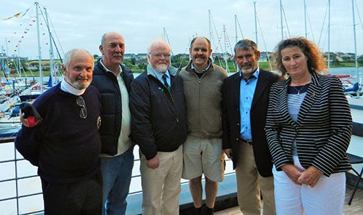
(L to R) Adrian O'Connell, Commodore Royal Western YCI , James Mc Cormack Commodore, Foynes YC, Pierce Purcell, Irish Sailing Association, Richard Hurley, Commmodore Tralee Bay SC, Louis Keating Managing Director L&M Keating, Kim Roberts, Kilrush Marina Manager.

Published in Irish Marinas
Tagged under

#seabed – A British government decision to slash 75 per cent of a proposed network of marine conservation zones (MCZs) intended to save seabeds and estuaries in England from being damaged by commercial and recreational activities, has been criticised by professional fishery managers.

The Department for Environment, Food and Rural Affairs (Defra) is proposing to go ahead with only up to 31 of 127 zones recommended by its advisors. It says it would be too expensive to set up more.

Responding to the watered-down proposals, the Institute of Fisheries Management (IFM) said it was "extremely disappointed" no more zones would be designated in the near future. Instead it called for "a clear timetable" for more, especially close inshore and for early discussions on how to manage and enforce them.

One zone the institute wants brought forward is in the Thames estuary which it says is one of the best studied estuaries in the UK, containing a wealth of well documented features fully meeting the MCZ criteria.

The estuary had long been a showcase for sustainable development. Most of the development challenges cited for delaying it were already being dealt with in a fully sustainable manner.

Another is the Alde-Ore estuary near Felixstowe, Suffolk. This contains a recruiting population of smelt (Osmerus eperlanus) a recognised MCZ flagship species. New evidence suggests a spawning run by these into the freshwater reaches of the estuary.

The institute agreed with the fisheries minister Richard Benyon that enforcing remote offshore zones could be costly, particularly if fishermen from other countries fished there.

Inshore, however, the use of sound and accessible science in selecting zones would engender strong commitment to self-enforcement among local sea users. Policing costs, including intelligence gathering, could then be "very low indeed."

There were already very good examples of self-enforcement in shell fisheries. In estuaries on the Thames and in Devon trawling restrictions had been maintained in an inclusive and coherent manner, at low cost.

Because Defra had not said how the zones would be managed and enforced the marine industry had, in some cases, provided "its own worst case scenarios," of the costs.

"This is an understandable reaction," according to Steve Colclough, chairman of the institute's marine section, "but it tends to militate against further designation [of more zones] in the near future."

Because of the uncertainty over management, some anglers felt that if estuaries became conservation zones they would be excluded from fishing in them. This was a factor in a number of cases and reassurances about a balanced approach carried little weight.

The institute was also disappointed the proposals did not refer to the socio-economic benefits of conservation zones. Around the world there was evidence they brought significant long-term benefits to fisheries, tourism and recreation. There had been early benefits to fishermen in recent examples of marine protection in England such as in Lyme Bay and Port Erin Bay on the Isle of Man.

Mr. Colclough said the institute was concerned about the balance of evidence and inconsistencies in some zone decisions. The rationale that estuaries, mudflats and salt marshes were some of the most productive aquatic ecosystems, was built into the reasoning for selecting some zones but not others.

The importance of conservation species such as the smelt had only been used in some decisions. For example, the Medway estuary was put forward for designation now, but data presented on the presence of a self-supporting population of smelt was not in the proposal. The institute said it was frustrating to be unable to see clearly where and how high quality information which it had provided had been used in making decisions.

"Such action tends to reduce the commitment and engagement so vital for success of these projects... We were promised [the MCZ process] would be transparent and fair, based on good science... Unfortunately we and others have noted specific data errors" which damaged the credibility of the whole process.

"These may seem small issues, but not to users who already feel threatened by the whole process. Understandable fear of the unknown quickly becomes antagonism."

As a professional body promoting more sustainable fisheries management, the Institute of Fisheries Management has a wealth of relevant experience, Mr. Colclough added, and said he looked forward to positive future engagement with Defra and others.

Published in Marine Wildlife

#INLAND WATERWAYS - A new study on the River Barrow and its environs recommends the development of "activity hubs, tourist trails and new angling and boat facilities", The Irish Times reports.

Waterways Ireland and Fáilte Ireland commissioned the Barrow Corridor Recreational, Tourism and Commercial Identification Survey to find ways to exploit the area's "undeveloped potential" for tourism.

The survey covered the river itself as well as its estuary and the Barrow branch of the Grand Canal. Its findings pointed to a number of areas where development is already being actioned, such as in boating and cruising, nature and wildlife, and angling.

Environment Minister Phil Hogan, who launched the study in Carlow yesterday, hailed the co-operation of the agencies and county councils involved.

The Irish Times has more on the story HERE.
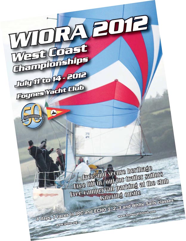
Published in Inland Waterways

#WIORA– As a flagship event to mark their 50th year of sailing on the Shannon EstuaryFoynes Yacht Club are setting an aggressive target to attract 50 boats to next year’s West of Ireland Offshore Racing Association (WIORA) sailing championships to be held from the 11th to 14th of July. The WIORA poster is below.

Ed Conway and Raymond McGibney are flying the flag for Foynes having being recently re-elected to the WIORA committee for another year.

IRC, ECHO and White Sails classes will be raced and the club says a festival atmosphere ashore will be 'guaranteed with well-priced, quality catering and top class live entertainment' provided at the recently renovated clubhouse. 

All boats entered will be given free and secure berthing.  Free lift-in/lift-out of trailer sailors will also be arranged.  Liam Dineen has been appointed OOD and already over forty boats have registered.

In addition to all Western clubs, Foynes will be canvassing sailors from the active racing fleet on Lough Derg to come by road or river to join in this celebration sailing event, last held in Foynes in 1998. 

While standard “around the cans” windward-leeward courses will be laid for the IRC and Echo fleets, more varied courses for white sails will be set, taking yachts to all parts of the scenic estuary. A special section is currently being added to the club website to cover all aspects of the event.

More on The Estuary here

wiora2012foynes

Published in WIORA

A north-easterly force 3 wind accompanied the flotilla of yachts that set out from Foynes Yacht Club, who sailed to Limerick city on Saturday afternoon to participate in the Riverfest celebrations.

Daniel Butler co-ordinator took members of the Northside We're Ok youth group from Moyross, who experienced another view of Limerick from the river. John Prendergast and his wife, Maureen, were guests of the club on this cruise.

The yacht's that journeyed were Mweeloon, Whyte Dolphin, Alphara, Inizi, Mariposa, Lady Shanannah, Hello, Kilteery, Kerry Dream, Battle, Dexterity, Coral Dos and Blue Ribbon. Unfortunately, Marengo had to turn back at Aughinish because of engine trouble, the skipper, Pat Finucane and crew changed boats and were transported on on Ger Reidy's, Kilteery.

The sun shone all the way for the sight-seeing journey up this magnificent of stretch of water. The Islands on the Shannon Estuary Cannon and Horseshoe are one of the first sights that can be seen on this stretch of the river. The bauxite smelting factory, Aughinish Alumina and the famous Beeves Rock lighthouse, no more in use gives an added pictureesque setting to this journey.

Further on the right-hand side the entrance into the Deel Boat Club in Askeaton can be seen on the the same shore the pre-Norman Beagh Castle is standing overlooking the Shannon. Ringmoylan, and Pallaskenry can be seen down a mile from the castle, and opposite Rineanna with the famous Shannon Airport, who hosted several US President's who stopped off to visit this country.

As we continued our journey up river the landmark, Carrigagonnell Castle is visible, also the giant chimneys of the Cement factory in Mungret and the giant-sized structure of Thomond Park.

Nearer to the city Riverpoint and the Clarion Hotel, two of the tallest buildings in Limerick, rise up to the blue sky and sunshine of May.

When the flotilla approached the Clarion Hotel, they berthed for an hour to give the public a chance to see these water vessels in their bunting and memorabilia.

After the inspections were it was into Limerick Docks for an overnight stay, and then on to Dolan's Bar and Restaurant for a much sought-after meal.

On Sunday afternoon the junior members of the club, Ailish Chawke, Claire Lowes, Ciara McCormack, Mary McCormack and Anna Lowes gave a display of sailing kayaks and Topaz boats at Howley's Quay to an array of spectators, who came to see the other craft on the water, Jet-Ski's and Clark Clifford's rib who gave the public a trip up and down the Shannon. Members of the yacht club also gave out flyers promoting Foynes Yacht Club.

When the sailing adventures were over it was time to head back down river to Cooleen Point, where a Bar-b-Que followed in the Clubhouse the sailors and their families. Overall, the reaction from everybody was excellent!

Club racing continus every Wednesday evening with first gun at 7pm. On Saturday, May 14 and Sunday, May 15 the Estuary Bell will be raced in Foynes. Two races on Saturday and one of Sunday are pencilled in.

Published in Shannon Estuary
26th October 2010

Dublin Boat Show Goes Afloat

The 2011 Dublin Boat Show is going on the water in 2011 if a new approach to promote boating in Ireland takes off. The Irish Marine Federation (IMF) aims to include as many boating activities as possible in the national boat show line up next May in Malahide.

An attendance of up to 17,000 are expected at the Malahide marina venue from May 20 to 22. It will be the first time the national event has taken to the water in its 50 year history.

The world's biggest boat builders Beneteau, Jeanneau, Sea Ray and Sunseeker among others have already signed up for the North Dublin event, according to the IMF.

The organisers are partnering with leading Irish boating organisations to demonstrate the many different aspects of the sport on the water with a weekend schedule of live commentary.

BJ Marine, MGM Boats, Western Marine, HM Yachts in Cork and Viking marine of Dun Laoghaire and Shannon Castle Line in County Clare are among the first of the Irish firms to express interest in the new format as exhibition details circulate through the industry this week.

The aim is to get as many class associations on the water as well as small powerboat racing such as Zzapcats, kayaking and match racing fans to stage short, sharp events on the estuary directly in front of the marina. A timetable of events will be published shortly. 

Coastguard and Lifeboat demonstrations are also planned. Technical demonstrations such as glass fibre repairs and engine maintenance are also in the line up.

Despite the coastal setting Ireland's Inland waters will feature prominently too through the Irish Boat Rental Association who will be promoting holidays on the river Shannon and Erne.

Visitors are also expected from Wales and across the Irish Sea region and special offers to both show-goers and exhibitors are being made through an Irish Sea Inter­Reg programme.

The Malahide exhibition site will feature a marine village ashore with over 500 square meters of undercover exhibit space. Show goers will get the chance to talk to the leading lights in the sport before going afloat on the marina where over 100 berths will be available.

"It's a pretty unique site that gives us the best chance to show off the marine leisure industry afloat and ashore. Because its just off the M50 and M1 motorways it means it's also so easy to get to from anywhere in the country. This will be a great day out." said the Federation's Steve Conlon.

More information from Steve Conlon on 087 6472746. Updates here on afloat.ie as the show takes shape.

Published in Marine Federation

General Information on using Waterways Ireland inland navigations

Safety on the Water

All users of the navigations are strongly recommended to make themselves aware of safety on the water for whatever activity they are involved in and to read the advice offered by the various governing bodies and by:

The Dept. of Transport, Ireland: www.gov.ie/transport and The Maritime and Coastguard Agency, UK, The RNLI – Water Safety Ireland for information in terms of drowning prevention and water safety.

Registration of Vessels

All vessels using the Shannon Navigation, which includes the Shannon-Erne Waterways and the Erne System must be registered with Waterways Ireland. Only open undecked boats with an engine of 15 horsepower or less on the Shannon Navigation, and vessels of 10 horsepower or less on the Erne System, are exempt. Registration is free of charge.

Craft registration should be completed online at: https://www.waterwaysireland.org/online-services/craft-registration

Permits for use of the Grand and Royal Canals and the Barrow Navigation

All vessels using the Grand and Royal Canals and the Barrow Navigation must display appropriate valid Permit(s) i.e A Combined Mooring and Passage Permit (€126) and if not intending to move every five days, an Extended Mooring Permit (€152).

Permit applications should be completed online at: https://www.waterwaysireland.org/online-services/canal-permits

Passage on the Royal and Grand Canals – Dublin Area

For boat passage through the locks east of Lock 12 into / out of Dublin on either the Royal or Grand Canals, Masters are requested to contact the Waterways Ireland Eastern Regional Office (M-F 9.30am-4.30pm) on tel: +353(0)1 868 0148 or email [email protected] prior to making passage in order to plan the necessary lock-keeping assistance arrangements.

On the Grand Canal a minimum of two days notice prior to the planned passage should be given, masters should note that with the exception of pre-arranged events, a maximum of 2 boats per day will be taken through the locks, travelling either east or west.

Movements in or out of the city will be organised by prior arrangement to take place as a single movement in one day. Boaters will be facilitated to travel the system if their passage is considered to be safe by Waterways Ireland and they have the valid permit(s) for mooring and passage.

Newcomen Lifting Bridge

On the Royal Canal two weeks’ notice of bridge passage (Newcomen Lifting Bridge) is required for the pre-set lift date, and lock assistance will then also be arranged. A minimum of 2 boats is required for a bridge lift to go ahead.

Waterways Ireland Eastern Regional Office (Tel: +353(0)1 868 0148 or [email protected] ) is the point of contact for the bridge lift.

A maximum number of boats passing will be implemented to keep to the times given above for the planned lifts (16 for the Sat / Sun lifts & 8 for the weekday lifts). Priority will be given on a first come first served basis.

On day of lift, boaters and passengers must follow guidance from Waterways Ireland staff about sequence of passage under bridge & through Lock 1, and must remain within signed and designated areas.

Events Held on the Waterways

All organised events taking place on the waterways must have the prior approval of Waterways Ireland. This is a twelve week process and application forms must be accompanied with the appropriate insurance, signed indemnity and risk assessment. The application should be completed on the Waterways Ireland events page at :

https://www.waterwaysireland.org/online-services/event-approval

Time Limits on Mooring in Public Harbours

On the Shannon Navigation and the Shannon-Erne Waterway craft may berth in public harbours for five consecutive days or a total of seven days in any one month.

On the Erne System, revised Bye Laws state that: No master or owner shall permit a vessel, boat or any floating or sunken object to remain moored at or in the vicinity of any public mooring, including mooring at any other public mooring within 3 kilometres of that location, for more than 3 consecutive days and shall not moor at that same mooring or any other public mooring within 3 kilometres of that location within the following 3 consecutive days without prior permission by an authorised official.

Winter Mooring on the Shannon Navigation and Shannon Erne Waterway

Winter mooring may be availed of by owners during the period 1 Nov to 31 Mar by prior arrangement and payment of a charge of €63.50 per craft. Craft not availing of Winter Mooring must continue to comply with the “5 Day Rule”. Winter Mooring applications should be completed online at : https://www.waterwaysireland.org/online-services/winter-moorings-booking

Owners should be aware that electricity supply and water supply to public moorings is disconnected for the winter months. This is to protect against frost damage, to reduce running costs and to minimise maintenance requirements during the winter months.

Vessel owners are advised that advance purchasing of electricity on the power bollards leading up to the disconnection date should be minimal. Electricity credit existing on the bollards will not be recoverable after the winter decommissioning date. Both services will be reinstated prior to the commencement of the next boating season.

Smart Cards

Waterways Ireland smart cards are used to operate locks on the Shannon Erne Waterway, to access the service blocks, to use the pump-outs along the navigations, to avail of electrical power at Waterways Ireland jetties.

Berthing in Public Harbours

Masters are reminded of the following:

  • Equip their vessel with mooring lines of appropriate length and strength and only secure their craft to mooring bollards and cleats provided for this purpose.
  • Ensure the available berth is suitable to the length of your vessel, do not overhang the mooring especially on finger moorings on floating pontoon moorings.
  • Ensure mooring lines, electric cables and fresh water hoses do not create a trip hazard on public jetties for others users.
  • Carry sufficient fenders to prevent damage to your own vessel, other vessels and WI property.
  • Allow sufficient space between your vessel and the vessel ahead /astern (c.1m) for fire safety purposes and /or to recover somebody from the water.
  • Do not berth more than two vessels side by side and ensure there is safe access/egress at all times between vessels and onto the harbour itself.
  • Do not berth in such a way to prevent use of harbour safety ladders, slipways or pump-outs.
  • Do not allow the bow of your vessel to overhang the walkway of a floating mooring thus creating a hazard for others with an overhanging anchor or bow fendering.
  • Animals are not allowed to be loose or stray at any time.
  • Harbour and jetty infrastructure such as railings, power pedestals, fresh water taps, electric light poles, safety bollards, ladders etc are not designed for the purpose of mooring craft , they will not bear the strain of a vessel and will be damaged.
  • At Carrybridge on the Erne System, Masters of vessels are not permitted to use stern on mooring. Masters of vessels must use the mooring fingers for mooring of vessels and for embarkation / disembarkation from vessels.

Passenger Vessel Berths

Masters of vessels should not berth on passenger vessel berths where it is indicated that an arrival is imminent. Passenger vessels plying the navigations generally only occupy the berths to embark and disembark passengers and rarely remain on the berths for extended periods or overnight.

Lock Lead-in Jetties

Lead-in jetties adjacent to the upstream and downstream gates at lock chambers are solely for the purpose of craft waiting to use the lock and should not be used for long term berthing.

Vessel Wake

Vessel wake, that is, the wave generated by the passage of the boat through the water, can sometimes be large, powerful and destructive depending on the hull shape and engine power of the vessel. This wake can be detrimental to other users of the navigation when it strikes their craft or inundates the shoreline or riverbank. Masters are requested to frequently look behind and check the effect of their wake / wash particularly when passing moored vessels, on entering harbours and approaching jetties and to be aware of people pursuing other activities such as fishing on the riverbank.

Speed Restriction

A vessel or boat shall not be navigated on the Shannon Navigation at a speed in excess of 5 kph when within 200 metres of a bridge, quay, jetty or wharf, when in a harbour or canal or when passing within 100 metres of a moored vessel or boat.

Vessels navigating the Shannon-Erne Waterway should observe the general 5 kph speed limit which applies along the waterway. This is necessary in order to prevent damage to the banks caused by excessive wash from vessels.

Vessels navigating the Erne System should observe the statutory 5kt / 6mph / 10kph speed limit areas.

A craft on the Royal and Grand canals shall not be navigated at a speed in excess of 6km per hour.

A craft on the Barrow Navigation shall not be navigated at a speed in excess of 11km per hour except as necessary for safe navigation in conditions of fast flow.

Bank Erosion

Narrow sections of all the navigations are particularly prone to bank erosion due to the large wash generated by some craft. Masters are requested to be vigilant and to slow down to a speed sufficient to maintain steerage when they observe the wash of their craft inundating the river banks.

Unusual Waterborne Activity

Unusual waterborne vessels may be encountered from time to time, such as, hovercraft or amphibious aircraft / seaplanes. Masters of such craft are reminded to apply the normal “Rule of the Road” when they meet conventional craft on the water and to allow extra room to manoeuvre in the interest of safety.

Sailing Activity

Mariners will encounter large numbers of sailing dinghies from late June to August in the vicinity of Lough Derg, Lough Ree and Lower Lough Erne. Sailing courses are marked by yellow buoys to suit weather conditions on the day. Vessels should proceed at slow speed and with due caution and observe the rules of navigation when passing these fleets, as many of the participants are junior sailors under training.

Rowing

Mariners should expect to meet canoes and vessels under oars on any part of the navigations, but more so in the vicinity of Athlone, Carrick-on-Shannon, Coleraine, Enniskillen and Limerick. Masters are reminded to proceed at slow speed and especially to reduce their wash to a minimum when passing these craft as they can be easily upset and swamped due to their very low freeboard and always be prepared to give way in any given traffic situation.

Canoeing

Canoeing is an adventure sport and participants are strongly recommended to seek the advice of the sport’s governing bodies i.e Canoeing Ireland and the Canoe Association of Northern Ireland, before venturing onto the navigations.

Persons in charge of canoes are reminded of the inherent danger to these craft associated with operating close to weirs, sluice gates, locks and other infrastructure particularly when rivers are in flood and large volumes of water are moving through the navigations due to general flood conditions or very heavy localised precipitation e.g. turbulent and broken water, stopper waves. Shooting weirs is prohibited without prior permission of Waterways Ireland.

Canoeists should check with lockkeepers prior entering a lock to ensure passage is done in a safe manner. Portage is required at all unmanned locks.

Canoe Trail Network – "Blueways"

Masters of powered craft are reminded that a canoe trail network is being developed across all navigations and to expect more organised canoeing along these trails necessitating slow speed and minimum wash when encountering canoeists, rowing boats etc

Rockingham and Drummans Island Canals – Lough Key

It is expected that work on Rockingham and Drummans Island Canals on Lough Key will be completed in 2021. Access to these canals will be for non-powered craft only, eg canoes, kayaks, rowing boats.

Fast Powerboats and Personal Watercraft (Jet Skis)

Masters of Fast Powerboats (speed greater than 17kts) and Personal Watercraft (i.e.Jet Skis) are reminded of the inherent dangers associated with high speed on the water and especially in the confines of small bays and narrow sections of the navigations. Keeping a proper look-out, making early alterations to course and /or reducing speed will avoid conflict with slower vessels using the navigation. Personal Watercraft are not permitted to be used on the canals.

Towing Waterskiers, Wakeboarders, Doughnuts etc

Masters of vessels engaged in any of these activities are reminded of the manoeuvring constraints imposed upon their vessel by the tow and of the added responsibilities that they have to the person(s) being towed. These activities should be conducted in areas which are clear of conflicting traffic. It is highly recommended that a person additional to the master be carried to act as a “look-out” to keep the tow under observation at all times.

Prohibition on Swimming

Swimming in the navigable channel, particularly at bridges, is dangerous and is prohibited due to the risk of being run over by a vessel underway in the navigation.

Age Restrictions on operating of powered craft

In the Republic of Ireland, Statutory Instrument 921 of 2005 provides the legal requirements regarding the minimum age for operating of powered craft. The Statutory Instrument contains the following requirements:

- The master or owner of a personal watercraft or a fast power craft shall take all reasonable steps to ensure that a person who has not attained the age of 16 years does not operate or control the craft

- The master or owner of a pleasure craft powered by an engine with a rating of more than 5 horse power or 3.7 kilowatts shall take all reasonable steps to ensure that a person who has not attained the age of 12 years does not operate or control the craft.

Lifejackets and Personal Flotation Devices (PFDs)

Lifejackets and PFD’s are the single most important items of personal protective equipment to be used on a vessel and should be worn especially when the vessel is being manoeuvred such as entering / departing a lock, anchoring, coming alongside or departing a jetty or quayside.

In the Republic of Ireland, Statutory Instrument 921 of 2005 provides the legal requirements regarding the wearing of Personal Flotation Devices. The Statutory Instrument contains the following requirements:

- The master or owner of a pleasure craft (other than a personal watercraft) shall ensure, that there are, at all times on board the craft, sufficient suitable personal flotation devices for each person on board.

- A person on a pleasure craft (other than a personal watercraft) of less than 7 metres length overall shall wear a suitable personal flotation device while on board an open craft or while on the deck of decked craft, other than when the craft is made fast to the shore or at anchor.

- The master or owner of a pleasure craft (other than a personal watercraft) shall take all reasonable steps to ensure that a person who has not attained the age of 16 years complies with paragraph above.

- The master or owner of a pleasure craft (other than a personal watercraft), shall take all reasonable steps to ensure that a person who has not attained the age of 16 years wears a suitable personal flotation device while on board an open craft or while on the deck of a decked craft other than when it is made fast to the shore or at anchor.

- The master or owner of a pleasure craft (other than a personal watercraft) shall take all reasonable steps to ensure that a person wears a suitable personal flotation device, at all times while – (a) being towed by the craft, (b) on board a vessel or object of any kind which is being towed by the craft.

Further information is available at: http://www.irishstatutebook.ie/eli/2005/si/921/made/en/print

Firing Range Danger Area – Lough Ree

The attention of mariners is drawn to the Irish Defence Forces Firing Range situated in the vicinity of buoys No’s 2 and 3, on Lough Ree on the Shannon Navigation. This range is used regularly for live firing exercises, throughout the year, all boats and vessels should stay clear of the area marked with yellow buoys showing a yellow "X" topmark and displaying the word "Danger".

Shannon Navigation, Portumna Swing Bridge Tolls

No attempt should be made by Masters’ of vessels to pay the bridge toll while making way through the bridge opening. Payment will only be taken by the Collector from Masters when they are secured alongside the jetties north and south of the bridge.

Navigating from Killaloe to Limerick on the Shannon Navigation

The navigation from Killaloe to Limerick involves passage through Ardnacrusha locks, the associated headrace and tailrace and the Abbey River into Limerick City. Careful passage planning is required to undertake this voyage. Considerations include: lock passage at Ardnacrusha, water flow in the navigation, airdraft under bridges on Abbey River in Limerick, state of tide in Limerick

Users are advised to contact the ESB Ardnacrusha hydroelectric power station (00353 (0)87 9970131) 48 hours in advance of commencing their journey to book passage through the locks at Ardnacrusha. It is NOT advised to undertake a voyage if more than one turbine is operating (20MW), due to the increased velocity of flow in the navigation channel, which can be dangerous. To ascertain automatically in real time how many turbines are running, users can phone +353 (0)87 6477229.

For safety reasons the ESB has advised that only powered craft with a capacity in excess of 5 knots are allowed to enter Ardnacrusha Headrace and Tailrace Canals.

Passage through Sarsfield Lock should be booked on +353-87-7972998, on the day prior to travel and it should be noted also that transit is not possible two hours either side of low water.

A Hydrographic survey in 2020 of the navigation channel revealed that the approach from Shannon Bridge to Sarsfield Lock and the Dock area has silted up. Masters of vessels and water users are advised to navigate to the Lock from Shannon bridge on a rising tide one or two hours before High Tide.

Lower Bann Navigation

The attention of all users is drawn to the “Users Code for the Lower Bann”, in particular to that section covering “Flow in the River” outlining the dangers for users both on the banks and in the navigation, associated with high flow rates when the river is in spate. Canoeists should consult and carry a copy of the “Lower Bann Canoe Trail” guide issued by the Canoe Association of Northern Ireland. Users should also contact the DfI Rivers Coleraine, who is responsible for regulating the flow rates on the river, for advisory information on the flow rates to be expected on any given day.

DfI Rivers Coleraine. Tel: 0044 28 7034 2357 Email: [email protected]

Lower Bann Navigation – Newferry – No wake zone

A No Wake Zone exists on the Lower Bann Navigation at Newferry. Masters of vessels are requested to proceed at a slow speed and create no wake while passing the jetties and slipways at Newferry.

Overhead Power Lines (OHPL) and Air draft

All Masters must be aware of the dangers associated with overhead power lines, in particular sailing vessels and workboats with cranes or large air drafts. Voyage planning is a necessity in order to identify the location of overhead lines crossing the navigation.

Overhead power line heights on the River Shannon are maintained at 12.6metres (40 feet) from Normal Summer level for that section of navigation, masters of vessels with a large air draft should proceed with caution and make additional allowances when water levels are high.

If a vessel or its equipment comes into contact with an OHPL the operator should NOT attempt to move the vessel or equipment. The conductor may still be alive or re-energise automatically. Maintain a safe distance and prevent third parties from approaching due to risk of arcing. Contact the emergency services for assistance.

Anglers are also reminded that a minimum ground distance of 30 metres should be maintained from overhead power lines when using a rod and line.

Submarine Cables and Pipes

Masters of vessels are reminded not to anchor their vessels in the vicinity of submarine cables or pipes in case they foul their anchor or damage the cables or pipes. Look to the river banks for signage indicating their presence.

Water Levels - Precautions

Low Water Levels:

When water levels fall below normal summer levels masters should be aware of:

Navigation

To reduce the risk of grounding masters should navigate on or near the centreline of the channel, avoid short cutting in dog-legged channels and navigating too close to navigation markers.

Proceeding at a slow speed will also reduce “squat” effect i.e. where the vessel tends to sit lower in the water as a consequence of higher speed.

Slipways

Reduced slipway length available under the water surface and the possibility of launching trailers dropping off the end of the concrete apron.

More slipway surface susceptible to weed growth requiring care while engaged in launching boats, from slipping and sliding on the slope. Note also that launching vehicles may not be able to get sufficient traction on the slipway once the craft is launched to get up the incline.

Bank Erosion

Very dry riverbanks are more susceptible to erosion from vessel wash.

Lock Share

Maximising on the number of vessels in a lock will ensure that the total volume of water moving downstream is decreased. Lock cycles should be used for vessels travelling each way.

High Water Levels:

When water levels rise above normal summer level masters should be aware of:

Navigation

Navigation marks will have reduced height above the water level or may disappear underwater altogether making the navigable channel difficult to discern.

In narrow sections of the navigations water levels will tend to rise more quickly than in main streams and air draft at bridges will likewise be reduced.

There will also be increased flow rates particularly in the vicinity of navigation infrastructure such as bridges, weirs, locks etc where extra care in manoeuvring vessels will be required.

Harbours and Jetties

Due care is required in harbours and at slipways when levels are at or near the same level as the harbour walkways' as the edge will be difficult to discern especially in reduced light conditions. It is advised that Personal Flotation Devices be worn if tending to craft in a harbour in these conditions.

Slipways

Slipways should only be used for the purpose of launching and recovering of water craft or other objects from the water. Before using a slipway it should be examined to ensure that the surface has sufficient traction/grip for the intended purpose such as launching a craft from a trailer using a vehicle, that there is sufficient depth of water on the slipway to float the craft off the trailer before the concrete apron ends and that the wheels of the trailer do not drop off the edge of the slipway. That life-saving appliances are available in the vicinity, that the vehicle is roadworthy and capable of coping with the weight of the trailer and boat on the incline. It is recommended that slipway operations are conducted by two persons.

Caution to be Used in Reliance upon Aids to Navigation

The aids to navigation depicted on the navigation guides comprise a system of fixed and floating aids to navigation. Prudent mariners will not rely solely on any single aid to navigation, particularly a floating aid to navigation. With respect to buoys, the buoy symbol is used to indicate the approximate position of the buoy body and the ground tackle which secures it to the lake or river bed. The approximate position is used because of the practical limitations in positioning and maintaining buoys in precise geographical locations. These limitations include, but are not limited to, prevailing atmospheric and lake/river conditions, the slope of and the material making up the lake/river bed, the fact that the buoys are moored to varying lengths of chain, and the fact that the buoy body and/or ground tackle positions are not under continuous surveillance. Due to the forces of nature, the position of the buoy body can be expected to shift inside and outside the charted symbol.

Buoys and perches are also moved out of position or pulled over by those mariners who use them to moor up to instead of anchoring. To this end, mariners should always monitor their passage by relating buoy/perch positions with the published navigation guide. Furthermore, a vessel attempting to pass close by always risks collision with a yawing buoy or with the obstruction that the buoy or beacon/perch marks.

Masters of Vessels are requested to use the most up to date Navigation guides when navigating on the Inland Waterways.

Information taken from Special Marine Notice No 1 of 2023