Menu

Ireland's sailing, boating & maritime magazine

Inland afloat headers


Displaying items by tag: irish sea

#MarineWildlife - Wildlife experts on the Isle of Man have been stumped by the carcass of an otter – a species not native to the island – found on Port Erin beach last Friday (15 January).

As BBC News reports, while the once severely threatened British otter population has recovered to the extent that the marine mammals can now be found in every county in England, they have never knowingly been a presence on Man – until now.

And with no microchip present on the animal to determine the deceased otter's origin, or indicate how it got to the island in the middle of the Irish Sea, the local wildlife trust has something of a mystery on its hands.

BBC News has more on the story HERE.

Published in Marine Wildlife

#MarineWildlife - Toxic chemicals banned in Europe nearly 30 years ago are still polluting the seas off the continent.

And marine scientists fear their continued presence could spell the end for the killer whale and other species in European waters, as the Irish Examiner reports.

The warning comes from newly published research on concentrations of polychlorinated biphenyls, or PCBs, in marine wildlife – specifically orcas and other dolphins – in Irish, British and Mediterranean waters.

Co-authored by Dr Simon Berrow of GMIT and the Irish Whale and Dolphin Group, the paper in the latest issue of journal Scientific Reports claims that despite the outright ban on the use of PCBs since 1987, they persist in "dangerously high levels in European cetaceans".

High exposure to PCBs, once used in the manufacture of paints and electrical equipment, weakens the immune systems of cetaceans and has a severe effect on their breeding rates.

The paper is available online HERE.

Published in Marine Wildlife

#Missing - The family of a man whose light aircraft is believed ditched in the Irish Sea have said they are "hoping against hope he may be found alive".

BBC News reports that the missing man has been named as Ian Stirling of Douglas on the Isle of Man.

The 73-year-old sparked a major search and rescue operation yesterday morning (Thursday 3 December) when the Rockwell Commander he was piloting disappeared from radar three miles offshore on approach to Blackpool Airport.

Debris and fuel spillage were found off the Lancashire coast before the search was suspended due to failing light, as previously reported on Afloat.ie.

Local council beach patrols have joined HM Coastguard in the search as it resumed earlier today. BBC News has more on the story HERE.

Published in Coastguard

#HistoricBoats - A team of scientists aboard the Marine Institute's research vessel Celtic Voyager has revealed detailed images of World War I shipwrecks in the Irish Sea.

The team, led by Dr Ruth Plets of the School of Environmental Sciences at Ulster University, set out to capture the highest resolution acoustic data possible of WWI shipwrecks lost in the Irish Sea, using a new multi-beam system (EM2040) on board the RV Celtic Voyager to get the best data ever acquired over these wrecks.

"We were able to capture the most detailed images of the entirety of the wrecks ever," said Dr Plets. "Some of the wrecks, which are too deep to be dived on, have not been seen in 100 years. So this is the first time we can examine what has happened to them, during sinking and in the intervening 100 years, and try to predict their future preservation state."

Among the shipwrecks surveyed were the SS Chirripo, which sank in 1917 off Black Head in Co Antrim after she struck a mine; the SS Polwell, which was torpedoed in 1918 northeast of Lambay Island; and the RMS Leinster, which sank in 1918 after being torpedoed off Howth Head, killing over over 500 people - the single greatest loss of live in the Irish Sea.

Marine Institute chief executive Dr Peter Heffernan welcomed the achievements of the survey, supported by the competitive ship-time programme, saying: "The multidisciplinary team is making an important contribution to understanding and protecting our maritime heritage and to our ability to manage our marine resource wisely."

Explaining how the survey was carried out, Dr Plets added: "We moved away from traditional survey strategies by slowing the vessel right down to allow us to get many more data points over the wreck, with millions of sounding per wreck."

"The detail is amazing as we can see things such as handrails, masts, the hawse pipe – where the anchor was stored – and hatches. Some of the vessels have split into sections, and we can even see details of the internal structure. With the visibility conditions in the Irish Sea, no diver or underwater camera could ever get such a great overview of these wrecks."

As well as acoustic imaging, the team collected samples from around the wreck to see what its potential impact is on the seabed ecology. Sediment samples were also taken for chemical analysis to determine if these wrecks cause a concern for pollution.

The project is carried out to coincide with WWI centenary commemorations, noted Dr Plets. "We often forget the battles that were fought in our seas; more emphasis is put on the battles that went on in the trenches. However, at least 2,000 Irishmen lost their lives at sea, but unlike on land, there is no tangible monument or place to commemorate because of the location on the bottom of the sea.

"In the Republic of Ireland there is a blanket protection of all wrecks older than 100 years, so all these will become protected over the next few years. To manage and protect these sites for future generations, we need to know their current preservation state and understand the processes that are affecting the sites."

The next step for the team is to use the data collected to create 3D models which can be used for archaeological research, heritage management and dissemination of these otherwise inaccessible sites to the wider public.

"There is so much data, it will take us many months if not years, to work it all up," said Dr Plets. "Some of the wrecks are in a very dynamic environment and we are planning to survey these vessels again next year to see if there is a change, especially after the winter storms. That will give the heritage managers a better idea if any intervention measures need to be taken to protect them.

"These data could well signal a new era in the field of maritime archaeology. We hope it will inspire a new generation of marine scientists, archaeologists and historians to become involved. Above all, we want to make the general public, young and old, aware of the presence of such wrecks, often located only miles off their local beach."

The research survey was supported by the Marine Institute, through its Ship-Time Programme, funded under the Marine Research Sub-Programme by the Government.

The diverse team included maritime archaeologists Rory McNeary from the Northern Ireland Department of the Environment and Kieran Westley from the University of Southampton; geologists Rory Quinn and Ruth Plets, both Ulster University; biologists Annika Clements from Agri-Food and Biosciences Institute and Chris McGonigle from Ulster University; Ulster University marine science student Mekayla Dale; and hydrographer Fabio Sacchetti from the Marine Institute who works on Ireland's national seabed mapping programme INFOMAR, run jointly with the Geological Survey of Ireland.

The team blogged about the seven-day survey at Scientists@Sea.

Published in Historic Boats

The last race of the ISORA Avery Crest Offshore series that was sponsored by LC Tyres, took place on Saturday 12th September with the race from Pwllheli to Dun Laoghaire (74 miles) writes ISORA's Peter Ryan. The boats compete for the famous “James Eadie” trophy. As like the same race last season, the weather forecast for the race and particularly the delivery to Pwllheli was not favourable all week. This put off many of taking part in what is normally a well supported end of season race.
The race was of more interest than usual due to the fact that the Overall Championship was still be be raced for with Liam Shanahan’s J109, “Ruth” and Andrew Hall’s J125, “Jackknife” only a 5 point apart and Peter Dunlop and Vicky Cox’s J109 “Mojito” close behind. While either “Ruth” or “Jackknife” could have taken the Series with a good result in the race, “Mojito” needed a well attended race to secure sufficient points in the high points scoring used by ISORA.
Of the 26 entries received for the race, 19 had confirmed taking part on the Monday prior to the race but only 9 came to the start on Saturday morning. Several boats had left Dun Laoghaire the previous morning but turned back when they were met with strong south easterly winds on the nose and a big sloppy sea. Those that persevered were rewarded with nearly “champagne” sailing for the race. Bryan Mullarkey’s Collins 40, “Harriet Marwood” was taking part in an ISORA race for the first time. Richard Mossop’s Oceanis 411, “Yachtzee” and David Simpson’s Swan 371 “Albeiro” were battling for the Overall Class 2.

ruth

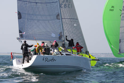
Liam Shanahan's Ruth from the National Yacht Club has successfully defended her 2015 ISORA offshore crown

Due to the uncertain forecast due to the presence of two depressions, north and south of the race area, the decision was taken to set the course from the start direct in Pwllheli to the finish between the pier heads in Dun Laoghaire.
Despite the poor forecast, the lashing winds during the night and the strong winds, conditions were relative pleasant for the start. The wind was 10-12 knots from the south west giving a beat to the first corner at St Tudwal’s Sound. Stephen Tudor’s J109, “Sgrech” was first off the line and lead the fleet until the faster “Jackknife” too to the front. From the start “Ruth” and Mojito” were always in close contact leaving.
As the fleet approached St Tudwal’s Sound the wind had increased to 20knots and the expected overfalls at the end of the sound awaited the fleet. The next leg was the beat to Bardsay Sound. The wind appeared to veer westerly and maintained the 20-22 knots leaving the fleet to beat through the rough seas towards Bardsey Sound. Fortunately, the tide was right for a fast shoot through Bardsey Sound. Unfortunately, the overfalls in the sound were significant but had settled soon after exiting it.

LC Tyrehunter logo
By that stage the battle was on. “Jackknife” cracked sails and took the direct line to Dun Laoghaire in the last of the north going tide. The remainder of the fleet retained their height and the three J109’s with Conor Fogarty’s 2-handed Jenneau 3600, “Bam”, bunched together for the leg to Dun Laoghaire. Shortly after leaving Bardsey the wind backed allowing the boats to ease sails and speed up. Of the bunch of four, “Bam” lead the group with “Ruth” and “Mojito” close behind and “Sgrech” snapping at their heels. Paul Sutton’s “Pipedreamer VI” was just behind this pack.
As the fleet approached the Irish coast the winds abated to 12 knots and backed further to the south allowing those with Code Zeros to accelerate. The positions within the fleet did not change for the long leg despite continuous trimming and hard driving being done on all the boats. It was not until approaching Dublin Bay that “things started to happen”. The winds became fickle and dropped further in Killiney bay. While “Jackknife” avoided much of the light wind to keep powering towards the line, the three J109’s and “Bam” got into a tactical battle with rapid sail changes taking place to deal with the oscillating winds. As the fleet approached Dublin Bay the wind veered to the west and decreased again giving the boats a short final beat to the finish line. Despite the work on each boat the positions generally remained the same.
“Jackknife” took line honours but could only manage 5th Overall allowing “Ruth”, who won the Overall race and Class1 to regain the ISORA Avery Crest Offshore Championship title. Class 2 was won by “Yahtzee” who also won Silver Class.
The crew of Liam Shanahan’s “Ruth” include his four sons. There is a great tradition of offshore racing in the Shanahan family with Liam Shanahan Snr playing a huge part in ISORA racing in the early days.
The race sponsor, LC Tyres, provided day prizes for the race. These were presented at the après sail party that took place in the NYC. The prizes were presented by Caroline Coyne aided by her son, Billy and daughter, Isobel.
The ISORA Avery Crest Offshore Championship trophy, the Wolf’s Head, will be presented to Liam Shanahan at the ISORA dinner in the NYC on the 14th November. “Jackknife” took 2nd place Overall and “Mojito” took 3rd place.
Overall Series Calls 1 was won by “Jackknife” and Class 2 was won by “Albeiro” who also took Overall Silver Class. The team prize, known as the “Victoria Cup”, was again won by Pwllheli Sailing Club.
All the results can be found on the ISORA website. The YB tracking of the race can also be accessed on the ISORA website and on the YB app for smart phones.

Published in ISORA

#Fishing - Was a fishing boat dragged backwards by a submarine in the Irish Sea?

That's what the crew of an Ardglass prawn trawler are saying after an incident yesterday afternoon (Wednesday 15 April).

As the Belfast Telegraph reports, skipper Paul Murphy says the 60-foot wooden-hulled trawler was some 18 miles off the coast, near the Calf of Man, when something snagged its nets.

“Without warning, were were stopped and pulled backwards very violently at around ten knots which is the top speed of the vessel. I really thought that was it," he says.

"It was fortunate that one of the steel ropes holding the net snapped or we would have been pulled under very quickly."

Murphy says the scary episode only lasted a few seconds, but still managed to cause thousands of pounds' worth of damage to his fishing gear – and alleges that the culprit was a submarine.

The Belfast Telegraph has more on the story HERE.

It wasn't the only drama in the Irish Sea yesterday, as a coastguard helicopter was scrambled to rescue three from a fishing boat that sank off Wicklow.

Published in Fishing
Tagged under

#MarineWildlife - Cute by name, cute by nature: Sherkin, Buoy and Splash were returned to the wild after being nursed back to health by the volunteers at Seal Rescue Ireland.

As the Irish Examiner reports, the three young seals – rescued after tips from the public from locations in Cork and Kerry – were rehabilitated over the past three months at the new marine wildlife refuge in Courtown.

But they were finally fit to return to the open water last weekend at Fountainstown beach in Co Cork. The Irish Examiner has much more HERE.

As three return to Irish waters, another says adieu – as Clet the lone dolphin has now been spotted off the Dorset coast, according to the Bournemouth Echo.

Last spotted between Ireland and Scotland's west coast in December, the solitary cetacean first noted in French waters in 2008 appears to have completed a full loop around the island of Ireland.

Along the way he bypassed Dingle's famous resident Fungie and spent a few days in the company of fellow 'dolphina-non-grata' Sandy, also known as Dusty.

Now he's attracting the attention of locals at Portland, south of Weymouth, across the English Channel from his original splashing grounds.

Closer to home, conservationists in the the North West of England have released a video documenting the wealth of wildlife living in the Irish Sea as a reminder to political movers and shakers of the importance of its protection.

Groups such as the North West Wildlife Trusts have criticised Westminster for 'lack of ambition' over the past year since plans for a network of well over 100 Marine Conservation Zones (MCZs) were scaled back to just 27 approvals in November 2013.

More recently a further 23 MCZs were designated proposed, only two of which are out of out of seven proposals covering the waters between Britain's west coast and Ireland (updated Tuesday 17 March).

Published in Marine Wildlife

#CancelledSailings – Met Eireann has issued a status 'orange' warning of gale to storm force winds tonight on all Irish coastal waters, which have led to widespread cancellation of ferry sailings across the Irish Sea.

Passengers are advised to consult for up to date information as sailings are cancelled tonight and for tomorrow (January 15). For up to date sailing information, click the ferry operator websites listed below.

Those travelling with Irish Ferries, should also take note that in addition to cancelled conventional sailings, the operators Dublin-Holyhead 'Swift' fast-ferry crossings are currently not in service as Jonathan Swift is on scheduled annual maintenance.

She headed for dry-docking in Birkenhead, where Ulysses as previously on Afloat.ie is also undergoing annual overhaul.

Isle of Man-England services are also effected to the adverse weather, with Isle of Man Steam Packet sailings on the Douglas-Heysham route cancelled today.

Further disruption and cancelled sailings (subject to which crossing) also apply to sailings tomorrow (January 15).

To recap, passengers are advised to check latest sailing information from the following website links:
Irish Ferries, Stena Line, P&O Ferries and the Isle of Man Steam Packet Co.

For additional information details are available by visiting the AA's ferrywatch service HERE

For weather forecasts visit Met Eireann's coastal reports and sea crossing's forecast visit this LINK.

Published in Ferry

#MarineWildlife - The grey seal who surprised Merseyside in the days before Christmas by getting lost in a field some 30km from the Irish Sea is now being treated for pneumonia, as The Guardian reports.

"He is much more settled now and still looks very sorry for himself, but other than that he is quite lively," said Sue Levings of the RSPCA's specialist seal facility in East Winch, Norfolk, where the young seal – named Dumbledore after the Harry Potter wizard – is being looked after.

As previously reported on Afloat.ie, the marine mammal was spotted by a dogwalker in a muddy field at Newton-le-Willows, north of Warrington and far from his species' usual seaside haunts.

Published in Marine Wildlife

#MarineWildlife - A very lost seal has been rescued after it was found exhausted in a field some 30km from the Irish Sea in northern England yesterday (22 December).

Yahoo News! reports that the young male grey seal was spotted by a dogwalker in a muddy field at Newton-le-Willows in Merseyside - and after some hours of attempts by rescuers, it was coaxed into a trailer and taken to a local wildlife hospital.

It's believed the young marine mammal swam up a tributary of the River Mersey from the Irish Sea on the trail of fish before getting hopelessly lost in the landlocked village north of Warrington.

Published in Marine Wildlife
Page 9 of 22

General Information on using Waterways Ireland inland navigations

Safety on the Water

All users of the navigations are strongly recommended to make themselves aware of safety on the water for whatever activity they are involved in and to read the advice offered by the various governing bodies and by:

The Dept. of Transport, Ireland: www.gov.ie/transport and The Maritime and Coastguard Agency, UK, The RNLI – Water Safety Ireland for information in terms of drowning prevention and water safety.

Registration of Vessels

All vessels using the Shannon Navigation, which includes the Shannon-Erne Waterways and the Erne System must be registered with Waterways Ireland. Only open undecked boats with an engine of 15 horsepower or less on the Shannon Navigation, and vessels of 10 horsepower or less on the Erne System, are exempt. Registration is free of charge.

Craft registration should be completed online at: https://www.waterwaysireland.org/online-services/craft-registration

Permits for use of the Grand and Royal Canals and the Barrow Navigation

All vessels using the Grand and Royal Canals and the Barrow Navigation must display appropriate valid Permit(s) i.e A Combined Mooring and Passage Permit (€126) and if not intending to move every five days, an Extended Mooring Permit (€152).

Permit applications should be completed online at: https://www.waterwaysireland.org/online-services/canal-permits

Passage on the Royal and Grand Canals – Dublin Area

For boat passage through the locks east of Lock 12 into / out of Dublin on either the Royal or Grand Canals, Masters are requested to contact the Waterways Ireland Eastern Regional Office (M-F 9.30am-4.30pm) on tel: +353(0)1 868 0148 or email [email protected] prior to making passage in order to plan the necessary lock-keeping assistance arrangements.

On the Grand Canal a minimum of two days notice prior to the planned passage should be given, masters should note that with the exception of pre-arranged events, a maximum of 2 boats per day will be taken through the locks, travelling either east or west.

Movements in or out of the city will be organised by prior arrangement to take place as a single movement in one day. Boaters will be facilitated to travel the system if their passage is considered to be safe by Waterways Ireland and they have the valid permit(s) for mooring and passage.

Newcomen Lifting Bridge

On the Royal Canal two weeks’ notice of bridge passage (Newcomen Lifting Bridge) is required for the pre-set lift date, and lock assistance will then also be arranged. A minimum of 2 boats is required for a bridge lift to go ahead.

Waterways Ireland Eastern Regional Office (Tel: +353(0)1 868 0148 or [email protected] ) is the point of contact for the bridge lift.

A maximum number of boats passing will be implemented to keep to the times given above for the planned lifts (16 for the Sat / Sun lifts & 8 for the weekday lifts). Priority will be given on a first come first served basis.

On day of lift, boaters and passengers must follow guidance from Waterways Ireland staff about sequence of passage under bridge & through Lock 1, and must remain within signed and designated areas.

Events Held on the Waterways

All organised events taking place on the waterways must have the prior approval of Waterways Ireland. This is a twelve week process and application forms must be accompanied with the appropriate insurance, signed indemnity and risk assessment. The application should be completed on the Waterways Ireland events page at :

https://www.waterwaysireland.org/online-services/event-approval

Time Limits on Mooring in Public Harbours

On the Shannon Navigation and the Shannon-Erne Waterway craft may berth in public harbours for five consecutive days or a total of seven days in any one month.

On the Erne System, revised Bye Laws state that: No master or owner shall permit a vessel, boat or any floating or sunken object to remain moored at or in the vicinity of any public mooring, including mooring at any other public mooring within 3 kilometres of that location, for more than 3 consecutive days and shall not moor at that same mooring or any other public mooring within 3 kilometres of that location within the following 3 consecutive days without prior permission by an authorised official.

Winter Mooring on the Shannon Navigation and Shannon Erne Waterway

Winter mooring may be availed of by owners during the period 1 Nov to 31 Mar by prior arrangement and payment of a charge of €63.50 per craft. Craft not availing of Winter Mooring must continue to comply with the “5 Day Rule”. Winter Mooring applications should be completed online at : https://www.waterwaysireland.org/online-services/winter-moorings-booking

Owners should be aware that electricity supply and water supply to public moorings is disconnected for the winter months. This is to protect against frost damage, to reduce running costs and to minimise maintenance requirements during the winter months.

Vessel owners are advised that advance purchasing of electricity on the power bollards leading up to the disconnection date should be minimal. Electricity credit existing on the bollards will not be recoverable after the winter decommissioning date. Both services will be reinstated prior to the commencement of the next boating season.

Smart Cards

Waterways Ireland smart cards are used to operate locks on the Shannon Erne Waterway, to access the service blocks, to use the pump-outs along the navigations, to avail of electrical power at Waterways Ireland jetties.

Berthing in Public Harbours

Masters are reminded of the following:

  • Equip their vessel with mooring lines of appropriate length and strength and only secure their craft to mooring bollards and cleats provided for this purpose.
  • Ensure the available berth is suitable to the length of your vessel, do not overhang the mooring especially on finger moorings on floating pontoon moorings.
  • Ensure mooring lines, electric cables and fresh water hoses do not create a trip hazard on public jetties for others users.
  • Carry sufficient fenders to prevent damage to your own vessel, other vessels and WI property.
  • Allow sufficient space between your vessel and the vessel ahead /astern (c.1m) for fire safety purposes and /or to recover somebody from the water.
  • Do not berth more than two vessels side by side and ensure there is safe access/egress at all times between vessels and onto the harbour itself.
  • Do not berth in such a way to prevent use of harbour safety ladders, slipways or pump-outs.
  • Do not allow the bow of your vessel to overhang the walkway of a floating mooring thus creating a hazard for others with an overhanging anchor or bow fendering.
  • Animals are not allowed to be loose or stray at any time.
  • Harbour and jetty infrastructure such as railings, power pedestals, fresh water taps, electric light poles, safety bollards, ladders etc are not designed for the purpose of mooring craft , they will not bear the strain of a vessel and will be damaged.
  • At Carrybridge on the Erne System, Masters of vessels are not permitted to use stern on mooring. Masters of vessels must use the mooring fingers for mooring of vessels and for embarkation / disembarkation from vessels.

Passenger Vessel Berths

Masters of vessels should not berth on passenger vessel berths where it is indicated that an arrival is imminent. Passenger vessels plying the navigations generally only occupy the berths to embark and disembark passengers and rarely remain on the berths for extended periods or overnight.

Lock Lead-in Jetties

Lead-in jetties adjacent to the upstream and downstream gates at lock chambers are solely for the purpose of craft waiting to use the lock and should not be used for long term berthing.

Vessel Wake

Vessel wake, that is, the wave generated by the passage of the boat through the water, can sometimes be large, powerful and destructive depending on the hull shape and engine power of the vessel. This wake can be detrimental to other users of the navigation when it strikes their craft or inundates the shoreline or riverbank. Masters are requested to frequently look behind and check the effect of their wake / wash particularly when passing moored vessels, on entering harbours and approaching jetties and to be aware of people pursuing other activities such as fishing on the riverbank.

Speed Restriction

A vessel or boat shall not be navigated on the Shannon Navigation at a speed in excess of 5 kph when within 200 metres of a bridge, quay, jetty or wharf, when in a harbour or canal or when passing within 100 metres of a moored vessel or boat.

Vessels navigating the Shannon-Erne Waterway should observe the general 5 kph speed limit which applies along the waterway. This is necessary in order to prevent damage to the banks caused by excessive wash from vessels.

Vessels navigating the Erne System should observe the statutory 5kt / 6mph / 10kph speed limit areas.

A craft on the Royal and Grand canals shall not be navigated at a speed in excess of 6km per hour.

A craft on the Barrow Navigation shall not be navigated at a speed in excess of 11km per hour except as necessary for safe navigation in conditions of fast flow.

Bank Erosion

Narrow sections of all the navigations are particularly prone to bank erosion due to the large wash generated by some craft. Masters are requested to be vigilant and to slow down to a speed sufficient to maintain steerage when they observe the wash of their craft inundating the river banks.

Unusual Waterborne Activity

Unusual waterborne vessels may be encountered from time to time, such as, hovercraft or amphibious aircraft / seaplanes. Masters of such craft are reminded to apply the normal “Rule of the Road” when they meet conventional craft on the water and to allow extra room to manoeuvre in the interest of safety.

Sailing Activity

Mariners will encounter large numbers of sailing dinghies from late June to August in the vicinity of Lough Derg, Lough Ree and Lower Lough Erne. Sailing courses are marked by yellow buoys to suit weather conditions on the day. Vessels should proceed at slow speed and with due caution and observe the rules of navigation when passing these fleets, as many of the participants are junior sailors under training.

Rowing

Mariners should expect to meet canoes and vessels under oars on any part of the navigations, but more so in the vicinity of Athlone, Carrick-on-Shannon, Coleraine, Enniskillen and Limerick. Masters are reminded to proceed at slow speed and especially to reduce their wash to a minimum when passing these craft as they can be easily upset and swamped due to their very low freeboard and always be prepared to give way in any given traffic situation.

Canoeing

Canoeing is an adventure sport and participants are strongly recommended to seek the advice of the sport’s governing bodies i.e Canoeing Ireland and the Canoe Association of Northern Ireland, before venturing onto the navigations.

Persons in charge of canoes are reminded of the inherent danger to these craft associated with operating close to weirs, sluice gates, locks and other infrastructure particularly when rivers are in flood and large volumes of water are moving through the navigations due to general flood conditions or very heavy localised precipitation e.g. turbulent and broken water, stopper waves. Shooting weirs is prohibited without prior permission of Waterways Ireland.

Canoeists should check with lockkeepers prior entering a lock to ensure passage is done in a safe manner. Portage is required at all unmanned locks.

Canoe Trail Network – "Blueways"

Masters of powered craft are reminded that a canoe trail network is being developed across all navigations and to expect more organised canoeing along these trails necessitating slow speed and minimum wash when encountering canoeists, rowing boats etc

Rockingham and Drummans Island Canals – Lough Key

It is expected that work on Rockingham and Drummans Island Canals on Lough Key will be completed in 2021. Access to these canals will be for non-powered craft only, eg canoes, kayaks, rowing boats.

Fast Powerboats and Personal Watercraft (Jet Skis)

Masters of Fast Powerboats (speed greater than 17kts) and Personal Watercraft (i.e.Jet Skis) are reminded of the inherent dangers associated with high speed on the water and especially in the confines of small bays and narrow sections of the navigations. Keeping a proper look-out, making early alterations to course and /or reducing speed will avoid conflict with slower vessels using the navigation. Personal Watercraft are not permitted to be used on the canals.

Towing Waterskiers, Wakeboarders, Doughnuts etc

Masters of vessels engaged in any of these activities are reminded of the manoeuvring constraints imposed upon their vessel by the tow and of the added responsibilities that they have to the person(s) being towed. These activities should be conducted in areas which are clear of conflicting traffic. It is highly recommended that a person additional to the master be carried to act as a “look-out” to keep the tow under observation at all times.

Prohibition on Swimming

Swimming in the navigable channel, particularly at bridges, is dangerous and is prohibited due to the risk of being run over by a vessel underway in the navigation.

Age Restrictions on operating of powered craft

In the Republic of Ireland, Statutory Instrument 921 of 2005 provides the legal requirements regarding the minimum age for operating of powered craft. The Statutory Instrument contains the following requirements:

- The master or owner of a personal watercraft or a fast power craft shall take all reasonable steps to ensure that a person who has not attained the age of 16 years does not operate or control the craft

- The master or owner of a pleasure craft powered by an engine with a rating of more than 5 horse power or 3.7 kilowatts shall take all reasonable steps to ensure that a person who has not attained the age of 12 years does not operate or control the craft.

Lifejackets and Personal Flotation Devices (PFDs)

Lifejackets and PFD’s are the single most important items of personal protective equipment to be used on a vessel and should be worn especially when the vessel is being manoeuvred such as entering / departing a lock, anchoring, coming alongside or departing a jetty or quayside.

In the Republic of Ireland, Statutory Instrument 921 of 2005 provides the legal requirements regarding the wearing of Personal Flotation Devices. The Statutory Instrument contains the following requirements:

- The master or owner of a pleasure craft (other than a personal watercraft) shall ensure, that there are, at all times on board the craft, sufficient suitable personal flotation devices for each person on board.

- A person on a pleasure craft (other than a personal watercraft) of less than 7 metres length overall shall wear a suitable personal flotation device while on board an open craft or while on the deck of decked craft, other than when the craft is made fast to the shore or at anchor.

- The master or owner of a pleasure craft (other than a personal watercraft) shall take all reasonable steps to ensure that a person who has not attained the age of 16 years complies with paragraph above.

- The master or owner of a pleasure craft (other than a personal watercraft), shall take all reasonable steps to ensure that a person who has not attained the age of 16 years wears a suitable personal flotation device while on board an open craft or while on the deck of a decked craft other than when it is made fast to the shore or at anchor.

- The master or owner of a pleasure craft (other than a personal watercraft) shall take all reasonable steps to ensure that a person wears a suitable personal flotation device, at all times while – (a) being towed by the craft, (b) on board a vessel or object of any kind which is being towed by the craft.

Further information is available at: http://www.irishstatutebook.ie/eli/2005/si/921/made/en/print

Firing Range Danger Area – Lough Ree

The attention of mariners is drawn to the Irish Defence Forces Firing Range situated in the vicinity of buoys No’s 2 and 3, on Lough Ree on the Shannon Navigation. This range is used regularly for live firing exercises, throughout the year, all boats and vessels should stay clear of the area marked with yellow buoys showing a yellow "X" topmark and displaying the word "Danger".

Shannon Navigation, Portumna Swing Bridge Tolls

No attempt should be made by Masters’ of vessels to pay the bridge toll while making way through the bridge opening. Payment will only be taken by the Collector from Masters when they are secured alongside the jetties north and south of the bridge.

Navigating from Killaloe to Limerick on the Shannon Navigation

The navigation from Killaloe to Limerick involves passage through Ardnacrusha locks, the associated headrace and tailrace and the Abbey River into Limerick City. Careful passage planning is required to undertake this voyage. Considerations include: lock passage at Ardnacrusha, water flow in the navigation, airdraft under bridges on Abbey River in Limerick, state of tide in Limerick

Users are advised to contact the ESB Ardnacrusha hydroelectric power station (00353 (0)87 9970131) 48 hours in advance of commencing their journey to book passage through the locks at Ardnacrusha. It is NOT advised to undertake a voyage if more than one turbine is operating (20MW), due to the increased velocity of flow in the navigation channel, which can be dangerous. To ascertain automatically in real time how many turbines are running, users can phone +353 (0)87 6477229.

For safety reasons the ESB has advised that only powered craft with a capacity in excess of 5 knots are allowed to enter Ardnacrusha Headrace and Tailrace Canals.

Passage through Sarsfield Lock should be booked on +353-87-7972998, on the day prior to travel and it should be noted also that transit is not possible two hours either side of low water.

A Hydrographic survey in 2020 of the navigation channel revealed that the approach from Shannon Bridge to Sarsfield Lock and the Dock area has silted up. Masters of vessels and water users are advised to navigate to the Lock from Shannon bridge on a rising tide one or two hours before High Tide.

Lower Bann Navigation

The attention of all users is drawn to the “Users Code for the Lower Bann”, in particular to that section covering “Flow in the River” outlining the dangers for users both on the banks and in the navigation, associated with high flow rates when the river is in spate. Canoeists should consult and carry a copy of the “Lower Bann Canoe Trail” guide issued by the Canoe Association of Northern Ireland. Users should also contact the DfI Rivers Coleraine, who is responsible for regulating the flow rates on the river, for advisory information on the flow rates to be expected on any given day.

DfI Rivers Coleraine. Tel: 0044 28 7034 2357 Email: [email protected]

Lower Bann Navigation – Newferry – No wake zone

A No Wake Zone exists on the Lower Bann Navigation at Newferry. Masters of vessels are requested to proceed at a slow speed and create no wake while passing the jetties and slipways at Newferry.

Overhead Power Lines (OHPL) and Air draft

All Masters must be aware of the dangers associated with overhead power lines, in particular sailing vessels and workboats with cranes or large air drafts. Voyage planning is a necessity in order to identify the location of overhead lines crossing the navigation.

Overhead power line heights on the River Shannon are maintained at 12.6metres (40 feet) from Normal Summer level for that section of navigation, masters of vessels with a large air draft should proceed with caution and make additional allowances when water levels are high.

If a vessel or its equipment comes into contact with an OHPL the operator should NOT attempt to move the vessel or equipment. The conductor may still be alive or re-energise automatically. Maintain a safe distance and prevent third parties from approaching due to risk of arcing. Contact the emergency services for assistance.

Anglers are also reminded that a minimum ground distance of 30 metres should be maintained from overhead power lines when using a rod and line.

Submarine Cables and Pipes

Masters of vessels are reminded not to anchor their vessels in the vicinity of submarine cables or pipes in case they foul their anchor or damage the cables or pipes. Look to the river banks for signage indicating their presence.

Water Levels - Precautions

Low Water Levels:

When water levels fall below normal summer levels masters should be aware of:

Navigation

To reduce the risk of grounding masters should navigate on or near the centreline of the channel, avoid short cutting in dog-legged channels and navigating too close to navigation markers.

Proceeding at a slow speed will also reduce “squat” effect i.e. where the vessel tends to sit lower in the water as a consequence of higher speed.

Slipways

Reduced slipway length available under the water surface and the possibility of launching trailers dropping off the end of the concrete apron.

More slipway surface susceptible to weed growth requiring care while engaged in launching boats, from slipping and sliding on the slope. Note also that launching vehicles may not be able to get sufficient traction on the slipway once the craft is launched to get up the incline.

Bank Erosion

Very dry riverbanks are more susceptible to erosion from vessel wash.

Lock Share

Maximising on the number of vessels in a lock will ensure that the total volume of water moving downstream is decreased. Lock cycles should be used for vessels travelling each way.

High Water Levels:

When water levels rise above normal summer level masters should be aware of:

Navigation

Navigation marks will have reduced height above the water level or may disappear underwater altogether making the navigable channel difficult to discern.

In narrow sections of the navigations water levels will tend to rise more quickly than in main streams and air draft at bridges will likewise be reduced.

There will also be increased flow rates particularly in the vicinity of navigation infrastructure such as bridges, weirs, locks etc where extra care in manoeuvring vessels will be required.

Harbours and Jetties

Due care is required in harbours and at slipways when levels are at or near the same level as the harbour walkways' as the edge will be difficult to discern especially in reduced light conditions. It is advised that Personal Flotation Devices be worn if tending to craft in a harbour in these conditions.

Slipways

Slipways should only be used for the purpose of launching and recovering of water craft or other objects from the water. Before using a slipway it should be examined to ensure that the surface has sufficient traction/grip for the intended purpose such as launching a craft from a trailer using a vehicle, that there is sufficient depth of water on the slipway to float the craft off the trailer before the concrete apron ends and that the wheels of the trailer do not drop off the edge of the slipway. That life-saving appliances are available in the vicinity, that the vehicle is roadworthy and capable of coping with the weight of the trailer and boat on the incline. It is recommended that slipway operations are conducted by two persons.

Caution to be Used in Reliance upon Aids to Navigation

The aids to navigation depicted on the navigation guides comprise a system of fixed and floating aids to navigation. Prudent mariners will not rely solely on any single aid to navigation, particularly a floating aid to navigation. With respect to buoys, the buoy symbol is used to indicate the approximate position of the buoy body and the ground tackle which secures it to the lake or river bed. The approximate position is used because of the practical limitations in positioning and maintaining buoys in precise geographical locations. These limitations include, but are not limited to, prevailing atmospheric and lake/river conditions, the slope of and the material making up the lake/river bed, the fact that the buoys are moored to varying lengths of chain, and the fact that the buoy body and/or ground tackle positions are not under continuous surveillance. Due to the forces of nature, the position of the buoy body can be expected to shift inside and outside the charted symbol.

Buoys and perches are also moved out of position or pulled over by those mariners who use them to moor up to instead of anchoring. To this end, mariners should always monitor their passage by relating buoy/perch positions with the published navigation guide. Furthermore, a vessel attempting to pass close by always risks collision with a yawing buoy or with the obstruction that the buoy or beacon/perch marks.

Masters of Vessels are requested to use the most up to date Navigation guides when navigating on the Inland Waterways.

Information taken from Special Marine Notice No 1 of 2023