


Displaying items by tag: marine science
Marine Scientist Inspired by Torrey Canyon Disaster is Honoured in New Oxford Dictionary
The work of a marine scientist and conservationist who pioneered a response to the Torrey Canyon supertanker environmental disaster of 1967 has been marked by the Oxford Dictionary of National Biography.
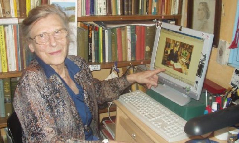
The late Stella Turk, a leading expert on molluscs on the British and Irish coasts, is among 241 people to have been acknowledged as history “shapers” in the publication’s new edition.
Turk ( née Phillips) was born in St Mary’s on the Scilly isles in 1925, and developed an interest in natural history from a young age. After she married Frank Archibald Turk, a conchologist and marine life expert, she further developed her expertise on the Cornish coast.
The Oxford Dictionary of National Biography entry records how the Torrey Canyon disaster of March 1967 had an enormous influence on her work
The supertanker struck a reef between Cornwall and Scilly and leaked some 30 million gallons of crude oil into the sea, polluting a large section of the Cornish coast.
Turk observed that “the rock pools were stripped bare” , and pointed out that quantifying the losses was made difficult by a lack of records of the pre-existing flora and fauna.
“ This seems to have focused the Turks even more sharply on the task of surveying and compiling lists of biological records for the county, continuing their extensive fieldwork, and corresponding with numerous national experts for assistance in specialist groups,” the Oxford publication says.
Turk founded the Cornish Biological Records Unit, which for many years she ran from her home in Reskadinnick, and later worked closely with the Cornish Wildlife Trust.
From 1990, she pioneered what is now Cornwall Wildlife Trust's Marine Strandings Network, which is of international standing.
In 2019, two years after her death in 2017, a research facility at the University of Exeter's Penryn Campus was named after her.
The Oxford Dictionary of National Biography is the national record of men and women who have shaped British history, worldwide, from prehistory to the year 2017. From January 2021 the dictionary includes biographies of 64,071 individuals, written by over 14,000 contributors.
Marine Technical Co-Ordinator - VACANCY FILLED
This vacancy has been filled - February 1 2021
P&O Maritime Services is a global company providing specialist maritime service solution through ownership, operation and management of a fleet of specialised vessels.
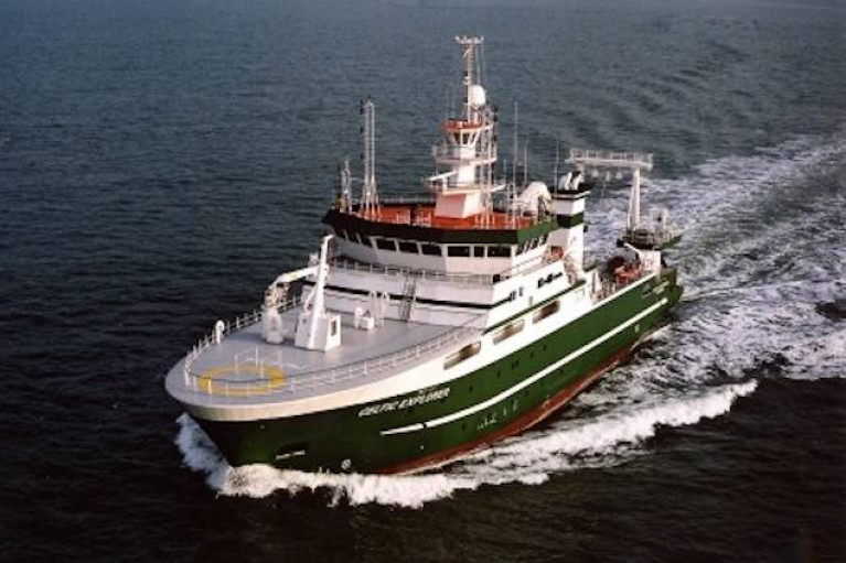
In Ireland, we manage Ireland's Marine Science vessels 'RV Celtic Explorer' and 'RV Celtic Voyager'.
Based in Galway, the Marine Technical Co-Ordinator will be responsible for Technical procurement and assist the Technical Manager with ship and scientific related projects.
Requirements:
- Relevant Bachelor of Engineering qualification or equivalent.
- It would be advantageous to have a minimum of 3 years relevant experience onboard ship as Engineer – preferably having a 2nd Engineer COC.
- Workshop & Fabrication skills plus a working knowledge of CAD / Engineering Drawing.
- Strong negotiation and communication skills.
- A background of working within an asset management role is desirable but not essential.
- Good Computer skills and experience with a computerized PMS / Purchase ordering system.
For a full job description or to apply for this role please send CV and covering letter to [email protected]
New Study Finds Coral in Ireland's Deepest Submarine Canyon Survives Extreme Conditions
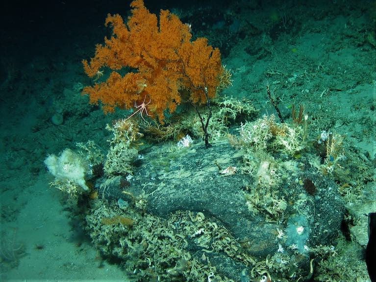
Irish cold-water corals can survive in extreme conditions within Ireland’s largest submarine canyon on the Porcupine Bank, a new study has found.
The coral even grows on precipices of high cliffs, and can withstand sea current speed of over 114 centimetres per second, according to the study published today in the science journal Nature.
This is the highest current speed ever recorded in a cold water habitat, according to University College Cork(UCC) scientist Dr Aaron Lim who led the research.
 An example of a 3D reconstruction of a cold-water coral habitat from -750 m water depth at the Porcupine Bank Canyon Photo: Aaron Lim
Dr Lim’s team used the Holland 1 remotely operated vehicle (ROV) on the State research ship Celtic Explorer to explore how coral are living in the Porcupine Bank Canyon which is 3,500 metres deep.
 The Marine Institue's Holland 1 ROV being deployed from the RV Celtic Explorer as it 'holds' the deep sea monitoring system (attached to the front) before descending to the deep sea Photo: Aaron Lim
He was part of the 2018 expedition which explored and mapped the canyon some 320 km west of Kerry, finding it full of cold-water corals forming reefs and mounds which create a rim on the lip of the canyon.
This latest expedition found coral in a range of deep marine settings.
The scientists had to use deep marine monitoring stations and three-dimensional reconstructions as part of the work. .
“These cold-water corals are growing at the very edge of a near-vertical cliff face, in Ireland’s largest submarine canyon some 850 m below the surface in very intense conditions. They’re quite literally living on the edge,” Dr Lim said.
 UCC's deep sea monitoring system at the edge of the submarine canyon where it collects marine environmental data for months at a time
As he explained, cold-water corals help to form deep-water reefs and mounds which can range from as little as ten metres to over 100 m high.
Some coral mounds have existed offshore Ireland for 2.6 million years, he said.
“Some of these habitats were predominantly alive, while others were mostly dead and so the aim of the study was to understand what is driving this?” Dr Lim said.
UCC marine geologist Luke O’Reilly described the canyon as “a strange-place; deep, dark and cold but full of life”.
“Together with the Marine Institute, we developed a monitoring system which could withstand these pressures and conditions for months at a time,” O’Reilly said.
Prof Andy Wheeler, head of UCC’s school of biological, earth and environmental sciences, noted that the coral can cope with the strong sea currents, but tend to feed when it slows down – such as when the tide turns.
The team have recently deployed monitoring stations in the canyon to gather information on survival over longer time scales.
The research was funded by Science Foundation Ireland and Horizon 2020, with co-funding by the Marine Institute and Geological Survey, Ireland. Shiptime was funded by the Marine Institute's National Shiptime Programme.
The study is published here
TCD Researchers Leading €10.4m 4-Oceans Project
Two researchers from Trinity College, Dublin (TCD) are among leaders of a €10.4 million project to assess the significance of marine resource exploitation over the past 2,000 years.
Archaeology, history and environmental science experts will collaborate in the “4-Oceans” project, funded by the European Research Council.
It has been billed as the “first-ever globalised evaluation” of the role of marine resources on human societies over two millennia.
TCD professor of environmental history Poul Holm and assistant professor of medieval environmental history Francis Ludlow are among a four-strong team of principal investigators.
This project combines expertise in marine environmental history, climate history, natural history, geography, historical ecology and zooarchaeology - spanning the humanities, natural sciences and social sciences.
Working with Prof Holm and Prof Ludlow as project leaders will be University of Cambridge medieval archaeology expert James H Barrett and NOVA University, Lisbon assistant professor Cristina Brito.
Prof Holm said the €10.4 million grant would facilitate “an unparalleled understanding of humanity’s recent interactions with the oceans”.
“Specifically, combining history and archaeology with marine science and socioeconomics, the 4-Oceans team will examine when and where marine exploitation was of significance to human society,”he said.
It would also explore “how major socio-economic, cultural, and environmental forces variously constrained and enabled marine exploitation”.
It would also research “the consequences of marine resource exploitation for societal development”, he said.
His colleague, Prof Ludlow said that “long-term data and an understanding of changes in ecosystems and human behaviour over many centuries is critical to informing the continued development of the UN’s Sustainable Development Goals and the Decade for the Oceans”.
So far, the historical dimension has been missing from this, he said, and the 4-Oceans project would “introduce much-needed chronological depth... through the understanding of our past”, he said.
Professors Holm and Ludlow will oversee €5.4 million of the €10.4 million research funding total allocated to 4-Oceans.
So far, TCD researchers have secured 37 European Research Council investigator grants to the value of about 68 million euro during the course of the EU’s Horizon 2020 framework for research and innovation, which is worth nearly €80 billion in total over six years.
TCD Provost Dr Patrick Prendergast welcomed the securing of the latest award.
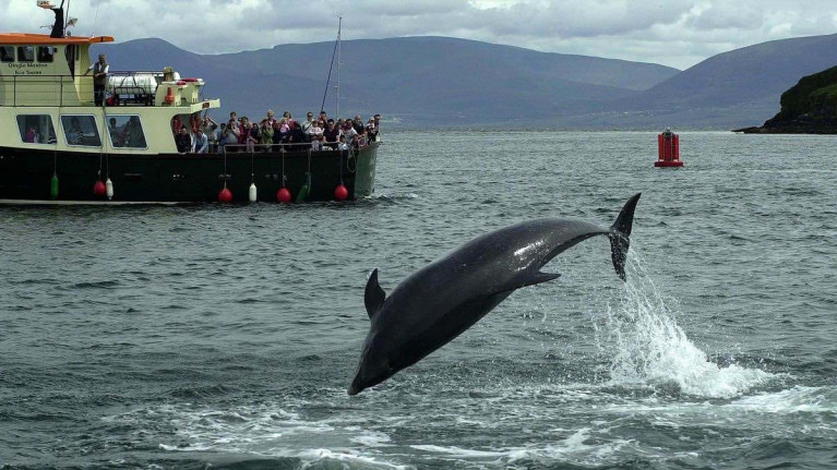
As hopes fade of Fungie’s return to Dingle, research suggests that “missing” dolphins are more likely to have migrated than died.
Dolphins in the Shannon estuary which were initially presumed to have perished had in fact moved to nearby bays, according to research published by the Irish Whale and Dolphin Group (IWDG).
The study by Kim Ellen Ludwig of Galway-Mayo Institute of Technology (GMIT) found that the “missing” dolphins had “emigrated” to Tralee and Brandon bays in Kerry, south of the Shannon estuary.
The Shannon estuary’s population of around 140 dolphins provided a good sample for the study, which Ms Ludwig conducted in collaboration with the IWDG.
The IWDG – a registered charity founded by Dr Simon Berrow in 1990 - has been monitoring the Shannon bottlenose dolphins since 1993. It constitutes the longest running whale or dolphin study in Ireland.
The group recently explored its 27-year old identification dataset to see if it could answer the question as to when to consider a dolphin as “dead” rather than missing.
Dolphins and whales are highly mobile, ranging thousands of kilometres.
Survival of young dolphins or calves is easier to monitor when they are dependent on their mothers for survival and is more difficult when calves are weaned.
The study with Ms Ludwig indicated that survival rate was 95.6% for “well-marked individual dolphins”- which means around 4.4% of adult dolphins die each year.
“For less well-marked individuals, survival increases to 5.8%, due to the higher chance a dolphin is “missed” during surveys,” it says.
The IWDG says that Ms Ludwig’s work highlights “a really important confounding factor, that of emigration outside the Shannon estuary to adjacent Tralee and Brandon bays”.
The dolphins had been presumed dead as these two bays are not routinely sampled during monitoring surveys.
Only by extending their surveys, did the IWDG realise that the dolphins were alive and well, and had extended their range.
Scientists with the IWDG are now recommending that the boundary of the lower river Shannon special area of conservation be extended to protect the important habitats of the bottlenose dolphins.
The group also suggests the area could be designated as a marine protected area as an alternative strategy.
In relation to Fungie, estimated to be 37 years old, the IWDG says that “as the time increases without a sighting and the search effort continues", it is "more likely" that he is dead rather than just simply missing.
However “his legacy will live on for years”, it says.
Marine Minister Confirms Funding for New Marine Research Vessel
Minister for Agriculture, Food and the Marine, Charlie McConalogue T.D., has earmarked the purchase of a new marine research vessel for the State in his Department's 2021 Budget.
As Afloat previously reported, €25m was allocated in Tuesday's budget to progress the construction of the vessel.
In making the announcement Minister McConalogue said: "The budget provision will allow the Marine Institute to progress construction on the replacement of the 21-year-old Celtic Voyager with a new 54m modern research vessel that will provide critical national infrastructure to enable Ireland to address the considerable challenges of Brexit and the Common Fisheries Policy as well as climate-induced impacts on our oceans."
 Celtic Voyager - 21 years old and in need of replacement Photo: Bob Bateman
Welcoming the news Dr Paul Connolly, CEO Marine Institute said: "The Marine Institute is delighted that work can continue on the replacement for the Celtic Voyager. This new vessel will enable Ireland to develop the best scientific advice possible to maximise economic opportunities for our coastal industries and communities and ensure a sustainable resource for them".
The construction of the new national research vessel will continue in 2021 with the build process expected to be completed in summer 2022. Spanish shipyard Astilleros Armon Vigo S.A. were awarded the contract to build the new marine research vessel for Ireland last year, following an extensive EU tender process.
Set to be one of the most advanced marine research vessels in the world, Ireland's new marine research vessel will enable Ireland to undertake critical research work to deepen our understanding of our oceans and our natural resources.
The new vessel will be able to go to sea for at least 21 days at a time and will be designed to operate in harsh sea conditions. Based in Galway, the vessel will be used by the Marine Institute, other State agencies and universities to undertake fisheries research, oceanographic and environmental research, seabed mapping and other multidisciplinary surveys. It will also maintain and deploy weather buoys, observational infrastructure and our Remotely Operated Vehicle (ROV Holland I).
The new vessel will be a sister ship to the State's largest research ship, the 65m RV Celtic Explorer and will replace the RV Celtic Voyager. The two Marine Institute research vessels currently in operation (RV Celtic Explorer and RV Celtic Voyager) are among the most intensively used research vessels in the world. The Marine Institute's RV Celtic Voyager is Ireland's first purpose built research vessel. It has been utilised heavily since its delivery 21 years ago and has been vital in providing marine scientists, researchers and its crew members, with many years of valued experience at sea, expanding and strengthening marine science in Ireland to help inform decisions affecting our ocean.
According to Dr Connolly, "The significantly enhanced capabilities of the vessel will help our researchers, educators, students and the public gain a deeper understanding of the ocean. Most importantly it will facilitate work that will support many of the projects outlined in the Programme for Government including fisheries assessment, offshore renewable energy, marine spatial planning, marine protected areas and research in the area of blue carbon."
Capital funding of €1.5m has also been allocated to the Marine Institute in Budget 2021, and funding for national research investment in marine-related activities will align with the Programme for Government and the needs of decision-makers.
Speaking about the additional funding announced in Budget 2021 Dr Connolly, said that "Research investments will add value to the core services provided by the Marine Institute to their national and international clients, including the Department of Agriculture, Food and the Marine. This new research data and knowledge will strengthen our scientific and technical advice to better inform decision-making on the sustainable management of our ocean and seas".
In 2021, the Marine Institute plans to fund a call for a large-scale project for researchers to investigate the potential for carbon storage and sequestration in Irish waters. This was highlighted as an important priority area for the Marine Institute in the Programme for Government. The work will examine a range of potential carbon storage alternatives such as algal absorption, seagrass forestry, deep-sea sinks, seabed layering and shellfish farming.
In welcoming the research expenditure allocations announced in Budget 2021, The Minister of State at the Department of Agriculture, Food and the Marine, Martin Heydon, T.D. said that "If we are going to continue to deliver efficiency and sustainability in the years ahead, innovation will be critical". The Minister also pointed out that the combined investment in Research and Innovation by the Department, Teagasc and the Marine Institute is now over €60m annually.
Calls for Ministerial Action & for Scientific Studies after High Court Ruling on Trawling Ban by Larger Vessels Inside 6 Nautical Miles
The Irish Wildlife Trust (IWT) has called on Minister for Marine Charlie McConalogue and Minister of State for Biodiversity Pippa Hackett to “act swiftly” over a High Court decision that overturns a ban on fishing by vessels over 18 metres long inside the six nautical mile limit.
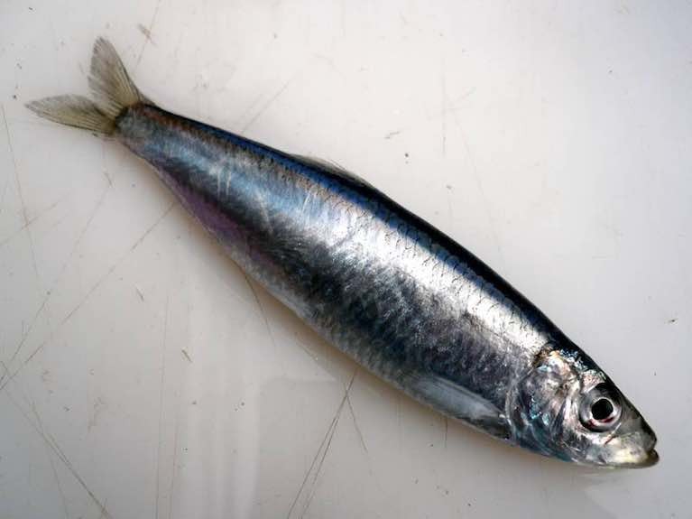
The Irish Whale and Dolphin Group (IWDG) has also called for a scientific study of species including sprat stocks in inshore waters.
A High Court judgment published last week found that the ban on trawling or fishing within seine nets by vessels over 18 metres in length inside the six-mile nautical limit has “no legal effect”.
Mr Justice Michael McGrath issued his judgment on foot of a judicial review of the ban which was introduced by former marine minister Michael Creed in March 2019.
The judicial review of the policy directive was taken by fishermen Tom Kennedy and Neil Minihane.
IWT campaign officer Pádraic Fogarty said that the original ban was initiated “after a public consultation in 2018 which was roundly supported by low-impact fishers in smaller boats, anglers, environmental groups and members of the public”.
“It was heralded at the time as the single most important move to protect fisheries and marine biodiversity that we have seen. There is consequently widespread anger and dismay that this has now been undone,” Mr Fogarty said in a statement.
“We’re urging ministers Hackett and McConalogue to act swiftly on this High Court decision and to tell us how the trawling ban can be reinstated on a permanent basis,” he said.
“ Until then we need to see all inshore trawling shut down so that any recovery in marine life which may have been underway is not completely undone,” Mr Fogarty said.
The IWT says that trawling for small fish such as sprat “removes the principle food source for sea life, whether its whales, dolphins or larger fish”.
“Bottom trawling, which scrapes a net across the seafloor, obliterates important habitats for fish spawning and should be phased out across our seas,” it says.
IWDG co-ordinator Dr Simon Berrow said that while he did not want to comment directly on the judgment, it was time for a “proper, robust scientific study” on sprat stocks.
“We know so little about sprat,” Dr Berrow told RTÉ Radio 1’s Seascapes on Friday night, pointing out how important the species is for whales.
The six-mile ban for larger vessels was introduced by Minister Michael Creed on 5th March 2019, and came into force on January 1st of this year.
The directive did give a derogation for fishing sprat within six nautical miles up to December 2021, “subject to any catch limits as may be determined by the minister from time to time”.
The Irish South and West Fish Producers Organisation (ISWFPO) has welcomed the judgment. Its chief executive Patrick Murphy said that “once again, we see flawed legislation being overturned in our High Court “.
“The view of IS&WFPO members remains that only a small proportion of fishing boats in our tiny Irish fishing fleet of 165 vessels of over 18 meters in length actually fish inside of the six-mile limit,” he said.
Mr Murphy concurred with the IWDG in calling for a scientific evaluation to calculate the biomass of all commercial stocks within the six-mile zone.
“Until this assessment is complete, we submit that no total allowable quota figure should be set for this important fishery,” he said.
What Impact of Marine Traffic on Whales in Irish Waters? New Study Launched
The waters off the south coast of Ireland have been selected as the study location for Ireland’s first real-time acoustic monitoring project of large whales, with the aim to relay warning alerts to maritime traffic to reduce the risk of disturbance and ship strikes.
The Automated Cetacean Acoustics Project (ACAP) is being undertaken by Ocean Research & Conservation Ireland, a “for-impact” non-profit organisation based in Cork, in partnership with the Rainforest Connection and supported by Huawei Ireland.
Huawei Ireland is providing a research grant with technological support through its global TECH4ALL initiative. TECH4ALL is Huawei’s digital inclusion initiative, using technology, applications and skills to empower people and organisations everywhere.
90% of Ireland’s international trade travels by sea, with the South Coast of Ireland one of the busiest heavy ship shipping lanes in the world. Thousands of large container ships pass through it from Eastern Canada to Liverpool and other European ports annually, as well as additional pleasure boats, speed crafts and eco-tour operators.
The South Coast is also an important foraging, resting and reproductive habitat for 25 cetacean species (whales, dolphins and porpoise) and particularly for large Humpback, Fin and Minke whales. Heavy ship traffic places whales at an increased risk of ship strikes causing injury or even death, and also raises the ambient noise pollution affecting all the species present.
The new study will see the deployment of acoustic monitoring equipment in the Celtic Sea at locations where sightings of whales and other wildlife have been recorded. The equipment will be able to listen for movements of whales, and with the help of machine learning models to enhance data analysis, for the first time provide near real-time detection. This will provide multiple benefits - helping with the identifying and classification of species in Irish waters, their distribution and behaviour, and most importantly, the development of an early warning system that will enable ships to reduce their speed in time to lessen the considerable risk of ship strikes.
The project will see Ireland leading the way in the advancement of policy and programmes that respect and protect marine wildlife informed by near real-time data available for the first time, with the help of Rainforest Connection and Huawei Ireland. Not only will the detections be able to help inform policy and decision-makers in the establishment and management of potential marine protected areas (MPA’s), they will also be used for education and made available to the wider public to hear the symphony of cetacean sounds.
Commenting, lead researcher Emer Keaveney, Marine Mammal Ecologist, Ocean Research & Conservation Ireland said: “Recent advances in technology provide increasing opportunity to use these innovations for good and to enhance our understanding of the natural world. This is such an exciting time as now we have a chance to peer inside the secret world of whales in Irish waters, and directly improve their welfare and conservation”.
“We are a voluntary organisation that relies heavily on third party and private assistance, so we are delighted to have this opportunity to work with Huawei Ireland.”
Emer Keaveney will discuss the project via livestream as part of the annual Huawei Connect summit, which takes place in Shanghai and online between 23rd - 26th September. Emer Keaveney is the only Irish speaker at the summit, which focuses on AI, 5G and digital innovation.
Commenting on the announcement, Tony Yangxu, CEO Huawei Ireland said: “Huawei has been a trusted partner for over 16 years in Ireland, and we are excited to be supporting Ocean Conservation & Research Ireland as our very first fully funded TECH4ALL initiative in Ireland.”
“Huawei believes that no one should be left behind in the digital world and we have made it our mission to put digital inclusion front and centre of our business. Our TECH4ALL programme centers on developing digital inclusion and empowerment initiatives with measureable outcomes. One of its many purposes is to help accelerate the UN’s SDGs and we hope that this project with ORC Ireland can contribute to that.”
75 per cent of Ireland's Land Territory Will Be Mapped this Year, GSI Says
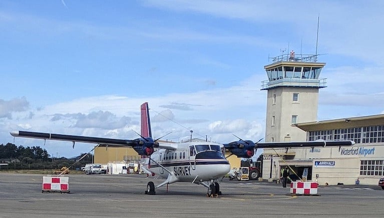
Ireland should have 75 per cent of its land territory mapped this year, according to the Geological Survey of Ireland (GSI).
A low-flying aircraft will gather geophysical date over counties Laois, Tipperary, Kilkenny and Waterford, and neighbouring parts of Offaly, Cork, Carlow and Kildare from September until the end of the year, weather permitting, the GSI says.
Based at Waterford airport, the survey plane will be flying at 60 metres over rural areas – about eight times the height of a two-storey house – and 240 metres over urban areas in the coming months, as approved by the Irish Aviation Authority.
The GSI is already involved in seabed mapping with the Marine Institute under the INFOMAR programme, and the Tellus Survey has been conducted on land over the last nine years.
Tellus collects geochemical and geophysical data on rocks, soil and water across Ireland. It involves airborne physical surveying using a low-flying aircraft, and ground-based geochemical surveying of soil, stream water and stream sediment.
It is currently funded under Project2040 - the National Development Plan – by the Department of Communications, Climate Action and Environment.
The department says it has “the potential to deliver positive economic, environmental and agricultural benefits by helping to assist in local environment understanding, soil management, and natural resource potential for these counties”.
Tellus project manager and senior geologist Dr James Hodgson describes it as “an important national project, providing valuable insights into the geological makeup of Ireland”.
“The data collected from the Tellus Survey helps us to sustainably manage our environment and natural resources as well as protecting public health,” he said.
The survey aircraft is a white, twin-propeller plane (as pictured), which is easily identified by its red tail and black stripe as well as the word ‘SURVEY’ and registration number C-GSGF written across both sides of the plane.
Data collected throughout the Tellus project is published and made freely available to all on the Tellus website (www.tellus.ie).
When Dr Kathy Sullivan (68) climbed out of a tiny submersible which had returned from the bottom of the Mariana Trench, none of the subsequent headlines were quite as clever as that “most vertical girl in the world” slogan coined by several of her friends.
It inspired a badge which she now wears -the first female US astronaut to walk in space and to reach the deepest known point of the world’s oceans has a sharp sense of humour. Some might say with her Irish lineage that she’d have to have – she has cousins on beautiful Beara peninsula.
Former Marine Institute chief executive Dr Peter Heffernan wisely developed that link through initiatives like the Atlantic Ocean Research Alliance when Dr Sullivan was US Under Secretary of Commerce for Oceans and Atmosphere and National Oceanic and Atmospheric Association Administrator (NOAA).
Dr Sullivan - an oceanographer and geologist - joins that panoply of individuals with Irish connections who have distinguished themselves over many centuries in the marine sphere, be it in fishing or trade, or in foreign navies, in exploration, or in technology and innovation.
 Kathy Sullivan is the first person to ever experience travelling to both space and the ocean's floor Photo: NASA
The lives of many of these mostly male marine pioneers - from St Brendan to submarine designer John Philip Holland and explorers Sir Ernest Shackleton and Edward Bransfield - have been documented by late maritime historian Dr John de Courcy Ireland among others. He was often asked by colleagues at international conferences to explain why so many Irish mariners of note had to go abroad to make their name.
These academics were curious to know why there was not much more lasting “Viking influence” in Irish socio-economic activity, given that Ireland’s coastal state population was not dissimilar in size to that of Norway. The “real map of Ireland” is at least ten times the land size - as that clever Marine Institute postcard image depicts - and our Continental Shelf position on a northerly latitude is tempered by the influence of the Gulf Stream
The impact of colonisation, including deliberate efforts to suppress the Irish fishing fleet when it became too competitive, were among reasons given by Dr de Courcy Ireland during a debate on this question at a conference on “Ireland the Sea”. It was hosted by the Merriman Summer School and Bord Iascaigh Mhara in Co Clare back in 1983.
I came across the paperback record of that debate, and it was welcome distraction during a brief “Covid-19 lockdown” office tidy. Conference participant and founding Irish Skipper editor Arthur Reynolds pointed to the uneconomic reality of 900 different landing points around the coast. The fertility of this island’s soil always made agriculture a more attractive bet, he said.
Labour Party politician Justin Keating, a vet and RTÉ Head of Agricultural Programmes, posed a more complex answer. During his time as industry and commerce minister almost a decade earlier, he had attempted to set up a “Statoil” model for hydrocarbon development here. He noted that the sea provided this State with “almost an embarrassment of riches, and a superb national challenge”.
“The fact that this potential had not been realised was not due to “genetics” or “laziness”, but due in part to economics and the “horrendously expensive” costs of certain maritime development, Keating said. However, there was also a confidence factor, he argued; we were only beginning to recover from a “profound culture shock” which was “not unique to us”.
The colonial experience had touched “everywhere in the world where people were defeated by newer and superior technology, from South-East Asia to the homelands of the North American Indians,” Keating said. He outlined one First Nation response to this shock - the “ghost dance”, and suggested the Irish version of this was our “fascination with words and music.... based on their use in a magic sense, for altering consciousness and for making reality go away....”.
Magic being illusionary, the only possible “national therapy” was development of our marine potential, in his view. Without mobilisation of capital – which had fled these shores over previous centuries – we would not “mobilise technology”, he said.
That same year, a marine management system which has had devastating results for coastal states like this one was rubberstamped. Just two EU states – Ireland and Denmark - had a surplus of fish at the time of Common Fisheries Policy (CFP) formulation.
The CFP is subject to ten-yearly reviews, which now place much greater emphasis on sustainability. Brexit creates a really serious challenge, as industry organisations have outlined, yet there seems to be a reluctance here to seek a more equitable revision of the policy, based on proximity to a resource.
As the late Castletownbere fishermen and industry leader Donal O’Driscoll pointed out, the initial deal struck in favour of agricultural benefits and structural funds was never intended by our EU masters to be “cast in stone”.
EU directives on the environment have had a more positive influence, though sometimes failing to protect communities from the pressures of the market. A template for democratic planning published by the British Institution of Civil Engineers four years ago cited this State’s handling of the Corrib gas project as an example of “how not to undertake a development”.
The methodology known as Global Risk and Strategic Assessment Planning (GRASP) developed by British chartered surveyor Michael Ocock, organisational psychologist Prof Agi Oldfield and colleagues aims to avoid selective consultation or a domination of debates by “rogue stakeholders” and the “space shuttle syndrome” identified in large scale projects which have taken a wrong turn. Scottish islanders have also taught us that sustainability is not about ticking consultation boxes, but about genuine stakeholder engagement and community return.
 Growing of seaweed
Like the tide coming in and out twice a day, the sea still throws up endless opportunities for change – seaweed culture as one example, which the late British scientist Dr Eric Edwards once forecast would be far more lucrative for Ireland than salmon farming. Fascinating work by the Bantry Marine Research Station in west Cork is exploring how a type of red seaweed could also reduce methane emissions in cattle – a valuable case, if realised, of “blue meets green”.
 Explorations off the Cork Coast could see Ireland's first floating offshore wind farm
That active Atlantic system which could turn Ireland into a “Green gulf” of renewable energy, in the words of one developer, could fuel home energy needs and bulk hydrogen exports. The 30-year strategy drawn up by the Eirwind consortium involving University College, Cork researchers Dr Val Cummins (now gone into private practice) and Dr Jimmy Murphy and industry cites the importance of prioritising the long-awaited marine planning framework and supporting legislation.
The reports by NUI Galway’s Socio-Economic Marine Research Unit which inform the government’s Harnessing Our Ocean Wealth strategy show a positive trend. It recently reported on the opportunities which coastal tourism could offer during this pandemic.
 Total expenditure by domestic tourists in coastal areas was estimated to be €698 million in 2018, which represents 35% of the total expenditure by domestic tourists that year, a new study says.
Complementing the research in third-level institutions and the efforts of the Marine Institute and BIM, there are also a plethora of individuals and non-governmental organisations who have helped to raise awareness of our maritime heritage and of our potential on the Atlantic margin.
Like Dr Sullivan, there are many women involved in the forefront of marine research, development, innovation, along with master mariners, harbourmasters, sailors like Olympic medallist Annalise Murphy and offshore yachtswoman Joan Mulloy. Yvonne Shields O’Connor, formerly of the Marine Institute, is chief executive of the Commissioners of Irish Lights, and Ireland’s first female master marine Capt Sinead Reen is in a senior role at the National Maritime College of Ireland.
And Irish people no longer have to leave to have an impact in that big blue field. Marine Institute chief executive Dr Paul Connolly has been at the helm of the prestigious International Council for the Exploration of the Seas (ICES), and his predecessor, Dr Heffernan, is one of 15 experts on the European Commission’s Mission Board for Healthy Oceans, Seas, Coastal and Inland Waters. And the unthinkable happened in 2015 when a former Naval Service flag officer, now Vice-Admiral Mark Mellett, became head of the Defence Forces.
 Vice-Admiral Mark Mellett, head of the Defence Forces
A global pandemic can focus attention on the potential of the ocean environment and the rich waters around this island - as a vital source of protein, new medical treatments and a source of renewable energy. However, a pandemic might also distract attention from its fragility, and the fact that man-made rubbish has reached the remote Mariana Trench and microplastics are poisoning the deepest ocean creatures.
 Plastic at the bottom of Mariana Trench Source: Sustainability Times
“We have taken for granted the fact that we have been fortunate to live in the Goldilocks zone – that sweet spot in relation to the Sun,” Dr Sullivan told me in a recent interview.
Ireland is in the sweetest “Goldilocks zone” when it comes to marine resources. We must be ready to manage that good fortune sensitively, and for both communities and individuals, when the gold rush comes.


 Michael Murphy Schull Harbour Sailing Club (SHSC), Eric Coogan Heineken Ireland, Mark Murphy, Commodore SHSC, Jack Allen SHSC, Carmel O'Regan SHSC, Cornelious Ndlovu, Schull Harbour Hotel Operations Manager and Derval Murphy SHSC")

