


Displaying items by tag: marine wildlife
Birdwatch Ireland has warned the government and wind farm developers of the risk of “creating a biodiversity crisis” in its approach to renewable energy.
As The Times Ireland reports today, Birdwatch Ireland's assistant head of advocacy Oonagh Duggan said the "renewable energy revolution in Ireland won’t be sustainable" if it is at the expense of biodiversity.
At the annual Wind Energy Ireland conference, Duggan said Birdwatch Ireland recognises that climate breakdown is critical, and that Ireland must meet its 2030 targets.
However, the Dáil had declared a biodiversity crisis, as well as a climate crisis, she noted.
Figures published earlier this week by Birdwatch Ireland show that a total of 54 Irish bird species (26%) are now on the “red list”, indicating the “highest status of concern” for their populations
Among 23 new entries to the “red list” are the kestrel, a bird of prey, along with the puffin, razorbill and kittiwake and the knot and snipe waders.
Main threats to birdlife are habitat loss and fragmentation, disturbance, poisoning, and persecution - largely driven by policies moving “in the wrong direction”, Duggan said.
Renewable infrastructure is “one more thing for birds to contend with”, due to the risks of bird strike/collision, displacement, barrier effects and habitat loss, she said.
A bird wind sensitive mapping tool for onshore wind, which had been developed by Birdwatch Ireland and circulated to local authorities, “wasn’t as widely used as we would have liked” and is a “cause of concern”, she said.
She also said the organisation was very concerned to ensure that marine protected areas (MPAs), which Ireland has committed to, were advanced before the roll-out of renewable energy.
Ireland could learn from Britain’s model in establishing a liaison group between the fishing industry and the renewable sector, Dale Rodmell of the National Federation of Fishermen’s Organisations (NFFO) told the conference.
This liaison group has developed a “best practice guidance on fisheries liaison”, which includes guidance on disruption settlements and community funds, he said.
A new version of this guide will focus on interactions between fisheries and cables in relation to planning and mitigation, he said.
“Two-way communication” is key, he said, and “co-existence” is best “tackled early” at the planning stage, he said.
Rodmell outlined the many risks posed by offshore wind farms to certain fishing activities, and said much depended on how farms were laid out and how much space there is between turbines.
Floating wind turbines - a new technology for deeper water - pose particular risks due to the need for mooring networks, he said.
He stressed the importance of “managing the relationship” on the ground with coastal communities, through agreed protocols and with potential community benefit initiatives such as funding for marine research projects.
Read The Times Ireland edition here
Impact of Ocean Noise Pollution on Ireland’s Marine Life Examined in Celtic Sea Study
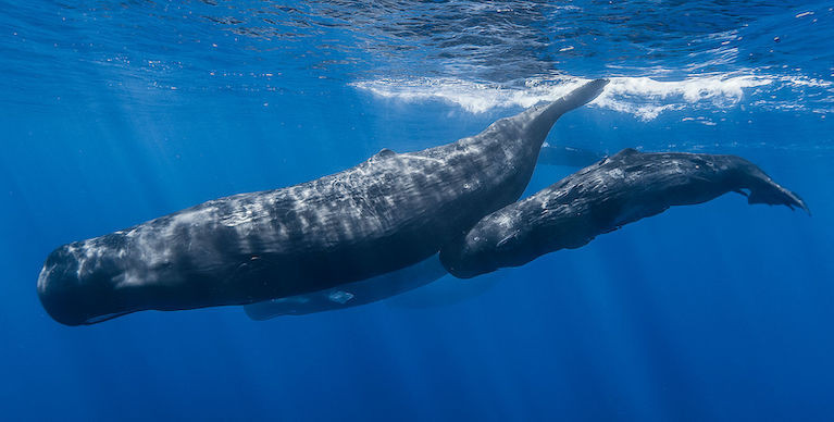
Ireland’s first real-time acoustic monitoring project of cetacean species (whales, dolphins and porpoise) began this week off the South Coast of Ireland, with the goal of creating a near real-time detection model for these species and examining the impact rising ocean noise pollution is having on Ireland’s marine life.
As Afloat reported last September, The Smart Whale Sounds project is being undertaken by Ocean Research & Conservation Association Ireland, a “for-impact” non-profit organisation based in Cork, in partnership with Rainforest Connection and supported by Huawei Ireland.
Following months of development, a 13ft 2 tonne specially designed data gathering buoy was deployed 9KM off the coast of Baltimore, Co. Cork for the next twelve months as part of the project. Attached to the buoy is an autonomous hydrophone (underwater microphone) that will record whale species in real-time and train sophisticated machine learning models to identify different species calls. The data will be used to create a marine wildlife detection and classification model, which has the potential to be applied to other projects across the globe.
 Dr Emer Keaveney, Marine Mammal Ecologist, Ocean Research & Conservation Association Ireland
Ireland’s South Coast has been chosen to conduct the study as it is one of the world’s most important foraging, resting and reproductive habitats for cetacean species. Ireland is home to 25 species of resident and migratory cetaceans which account for 48% of all mammals found in Ireland, and one-third of all cetaceans found worldwide.
Commenting on the project, lead researcher Emer Keaveney, Marine Mammal Ecologist, Ocean Research & Conservation Association Ireland said: “Increased levels of marine traffic from container ships, pleasure boats, speedboats and eco-tour operators has created a significant noise pollution issue. Sound pollution causes as much damage to marine life as overfishing, pollution and climate change, and is believed to cause behavioral changes that interfere with the health and survival of the animals. Informed estimates suggest that ocean noise levels are at least 10 times higher today than they were a few decades ago.”
 Attached to the buoy is an autonomous hydrophone (underwater microphone) that will record whale species in real-time
The Smart Whale Sounds project will provide a much greater understanding of what is happening on Ireland’s ocean floors - specifically helping with the identification and classification of species in Irish waters, their distribution and behaviour and how noise pollution is changing these patterns. In the long-term, it could potentially lead to the development of an early warning system that will enable ships to reduce their speed in time to lessen the considerable risk of whale ship strikes.
Huawei Ireland will be providing technical support and assistance as part of its global TECH4ALL initiative. TECH4ALL is Huawei’s digital inclusion initiative, using technology, applications and skills to empower people and organisations everywhere. Smart Whale Sounds is the first TECH4ALL project to be launched in Ireland and the first to focus on the ocean and marine wildlife globally.
Commenting on the launch, Tony Yangxu, CEO of Huawei Ireland said: “Huawei has been a trusted partner for over 16 years in Ireland, and we are delighted to support the great work being done by ORCA Ireland. The Smart Whale Sounds project will see Ireland leading the way in using technology and data to have a greater understanding of marine life and help inform how best to manage potential marine protected areas.”
“Huawei Ireland is invested in ensuring digital inclusion goes beyond the doors of our company and reaches every corner of Ireland, and look forward to going on this voyage with the ORCA Ireland team.”
Concluding Rainforest Connection CEO Topher White said: “No matter where we look on earth, life expresses and asserts itself through sound. There’s no better way to tap into the subtlety and the essence of ecology than through how nature calls to itself.
To capture this at scale within our oceans, and harness the power of cloud-AI and big-data analysis to gather the ecological insight, is the beginning of an unprecedented era of ambitious scientific discovery and critical conservation work.”
World Wetlands Day Marked in Ireland With Photo Contest
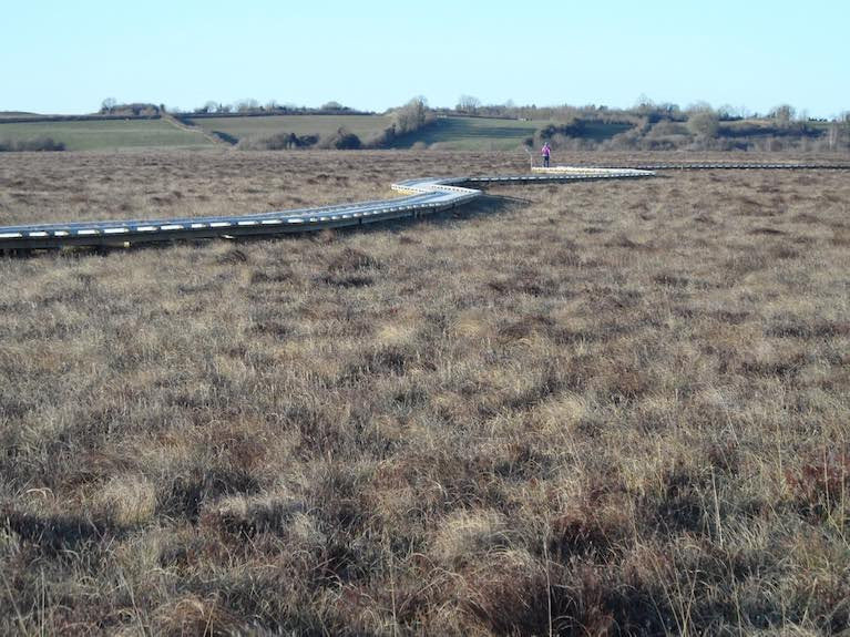
They might be small pockets of marshy ground, or they could be on bogs, in estuaries, or turloughs.
All these are wetland habitats, and are the focus of a new photographic contest to mark World Wetlands day today, February 2nd.
The global event marks 50 years since the signing of the Ramsar Convention, an international agreement on conservation and “wise use” of wetlands.
Ireland is a signatory to the agreement which aims to ensure protection of the ecosystems which tend to be taken for granted.
The Irish Ramsar Wetlands Committee says that a combination of geology and abundant rain has “endowed Ireland with an extraordinary array of wetlands covering some 20% of the country”
 The Clara Bog Ramsar site Photo: Peter Foss of Wetland Surveys Ireland
“There are many types of wetlands ranging from lakes, rivers, turloughs, bogs and estuaries to fens, marshes, wet woodlands, heaths and machair,” it says.
“While many wetlands are protected under EU environmental legislation, 45 of Ireland’s wetlands are Ramsar sites,” it says, and are part of the global Ramsar network.
These sites include Tralee Bay, Lough Corrib, Pollardstown Fen, Clara Bog and Coole Lough and Garryland wood.
Irelands Ramsar sites are important for their variety of wetlands habitats, for wintering and breeding birds and for plants, mammals and invertebrates.
Some 40% of all species live or breed in wetlands, and wetlands store 30% of land-based carbon which is vital for climate change mitigation.
The ecosystems also remove pollutants from circulation and provide protection from flooding and storms.
A video series is being rolled out today, launched by EcoEye presenter Anja Murray, with more details on Irish wetlands.ie
Photos of wetland habitats can be submitted via the Wetland Surveys Ireland Snapshot App until May 31st.
Prizes include OPW Family Heritage Cards, Biodiversity Ireland Swatch cards and inclusion in a 2022 Irish Wetlands Calendar.
Significant Funding Boost for Environmental NGOs

Minister Ryan has announced significant funding of €1,764,000 for the Irish Environmental Network and its members in 2021. This is an increase of €704,000 on the level of funding provided in 2020.
The Irish Environmental Network is made up of over 30 environmental groups from around the country including BirdWatch Ireland, the Irish Wildlife Trust, VOICE and Friends of the Earth.
The network also includes the marine wildlife organisation, the Irish Whale and Dolphin Group.
An Taisce, the administrator of the bleu Flag scheme for beaches and marinas is also a member.
Minister Ryan commented, “I am very aware of the critical work carried out by the member organisations of the Irish Environmental Network (IEN). These national environmental NGOs are active on a broad range of environmental issues, including wildlife conservation, biodiversity and climate change.
‘I have worked closely with the IEN members for many years and I have met them on a number of occasions since I became Minister. I am very aware of the financial challenges the sector has faced over the last number of years and how the Covid 19 pandemic has impacted on these organisations. Their role in how we address the climate and biodiversity challenges we face has never been more crucial.
‘Therefore I am pleased to be able to deliver this substantial increase in their financial supports so that they can continue to build on their great work. I do this in recognition of the significant contribution they continue to make to Ireland's fight against climate change.”
Christmas Whales off the Waterford Coast
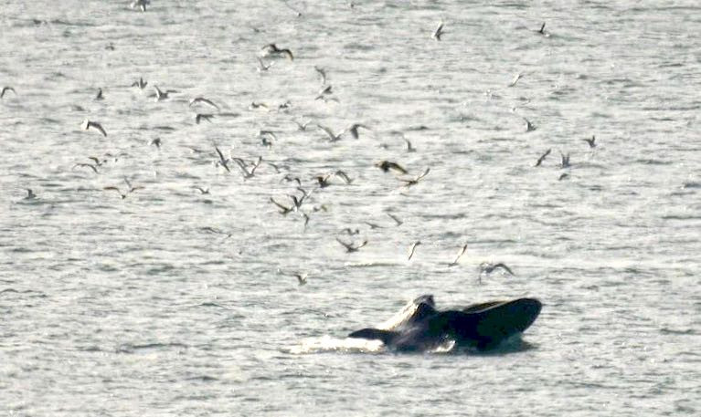
The Irish Whale and Dolphin Group is reporting a sighting of large Fin Whales close to the shore at Hevlick Head on the County Waterford Coast.
Andrew Malcolm photographed and identified the pod close to shore feeding.
There were at least five animals present in two groups on Christmas Day.
More details from the IWDG here.
Christmas Whales, 5 off co Waterford's Helvic Headhttps://t.co/FjnX1EBb1K
— ? Cork Coast (@CorkCoast) December 26, 2020
Large Fin whales 25th December.
IWDG Images by Andrew Malcolm - IWDG, Cárthach Ó Faoláin#iwdg #whales #whale #waterford pic.twitter.com/Z0q9cLzqf4
Deep Sea Angler Ronald Surgenor Wins Marine Conservation Award
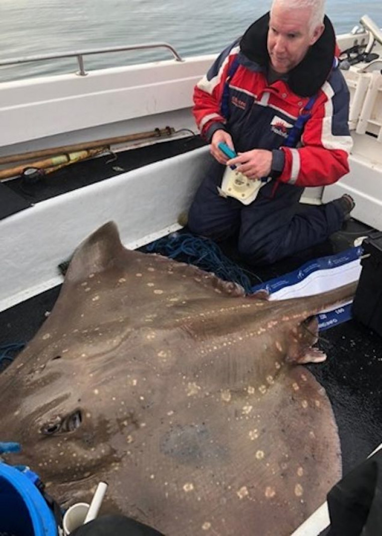
Ronald Surgenor is a Project Officer with the Ulster Wildlife Trust and has been awarded the Marsh Volunteer Award for Marine Conservation. As well as caring for nature reserves and peatlands, Ronald is a dedicated volunteer sea-angler for the shark conservation project 'Sea Deep'. Since 2018, he has tagged over 100 sharks, skates and rays, and was the first angler to be granted a license to tag common skate for the project. His records make up 75% of all our skate records, contributing to this critically endangered species' conservation and management.
This Award is run in partnership with the Wildlife Trusts. It recognises a volunteer who has made an outstanding contribution to marine conservation and furthered the work of the Wildlife Trusts in this area.
Rays and skates are a species of fish closely related to sharks and are dorso-ventrally flattened. This gives them an added advantage to be able to glide along the sea-floor. Rays and skates are similar in appearance, and the White Skate and the Flapper Skate are just two of the 500 skate and ray species in the world. Of these 28 are found in the waters around Ireland.
Ronald, a berth holder in Bangor Marina, says " We fish anywhere between Malin Head and Belfast Lough, depending on the species we are trying to catch and the time of year. Most of the fish tagged have been on my angling friend's boat The Mistress, a Redbay 21 and perfect for angling". Ronald has a Shetland Sheltie berthed in Bangor during the summer months and from it, he targets the smaller shark species such as Black-mouthed dogfish which are a deep-water species which he has only recorded in an area between the south of Rathlin Island, off the North Coast, and the entrance to Belfast Lough in 90 m plus depth. He adds " The Flapper Skate can only be targeted by anglers trained and licensed in best practice handling these endangered animals, for tagging and collecting DNA samples".
Ronald explained " The fish would be out of the water for about a minute – we have all the tagging and DNA kit ready so as soon as the fish is landed, with the measure mat and sling for lifting them back out of the boat ready on the deck. We can recognise signs of stress so that we have a minimum impact. I have caught the same fish on three occasions, twice in the one day and then six months later".
Marina Manager Kevin Baird commented, "Well done from all the Marina team. delighted that Ronald Surgenor has been awarded the Marsh Volunteer Award for Marine Conservation".
Noise of Bottom Trawling Disturbs Marine Mammals, NUIG Study Finds
Whales are known to be disturbed by the noise of ships and oil and gas drilling, but now a new study says that bottom trawling can also upset marine mammals.
As the Irish Independent reports today, scientists at NUI Galway’s (NUIG) Ryan Institute have found that the sound generated by trawling for fish around underwater canyons is amplified and may affect marine mammals’ ability to hunt and navigate.
The team used hydrophones to record the impact on the marine environment of trawlers in two surveys in the Irish Sea and Celtic Sea.
Ecologically sensitive areas of the oceans need stronger environmental protection from the wide variety of potential pollution sources, including ships, deep-sea mining and bottom trawling, the team suggests.
The scientists modelled how the noise generated by bottom trawling could travel through the water column, along the seabed, and through a 20km long submarine canyon in the Porcupine Basin off the south-west Irish coast.
They found the noise funnels through underwater canyons and into deeper waters, affecting marine mammals feeding and migrating.
They also discovered that “modelled trawler sound” generated on the seabed travels underwater more “efficiently” than sound generated at the surface by boats.
Eoghan Daly, a PhD researcher with NUIG’s Irish Centre for Research in Applied Geosciences (iCRAG), said that raised levels of marine noise can “interfere with a marine mammal’s ability to communicate, hunt and navigate using echolocation”
“Human-derived noise in the world’s oceans comes from many sources”, but “ bottom trawling’s impact has received “little attention to date”, he said.
“In an ocean already faced with plastic pollution and climate change, a better understanding of trawler noise pollution will highlight it as another human impact on the marine ecosystem,” Daly said.
The NUIG team’s findings have been published in the scientific journal, Marine Pollution Bulletin.
The team hopes their research will inform improved environmental regulations near key marine habitats, marine protected areas (MPAs) and any additional special areas of conservation in Irish waters.
Ireland has set a target of designating a total of 30% of its maritime area as MPAs by 2030.
“The research fills an important gap in marine noise pollution monitoring,” Dr Martin White of NUIG said.
“Areas such as the Porcupine Basin and the wider European continental margin are ecologically sensitive, and trawlers operating in this part of the Atlantic Ocean have more powerful engines and heavier gear,” he said.
“The enhanced currents and nutrient mixing in these parts of the ocean help create good conditions for cold-water coral mounds and for associated invertebrates, fish and mammals to thrive,” he noted.
Marine life should be protected from the wide variety of pollution sources, including ship noise, pile driving and from bottom trawling, as we now know,” he said.
Read The Irish Independent here
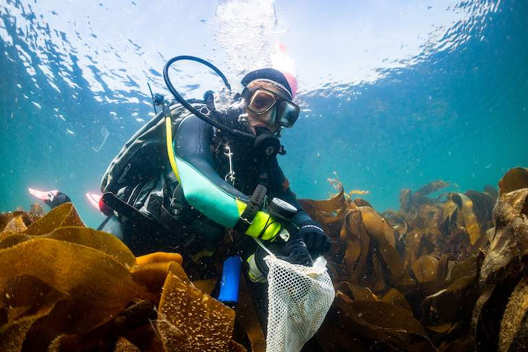
A leading specialist in the ecology of Irish kelp forests along the Atlantic coastline has been given an award by the Irish Research Council (IRC).
NUI Galway marine ecologist Dr Kathryn Schoenrock has been given Early Career Researcher of the Year award.
Dr Schoenrock is a post-doctoral researcher who has led an intensive monitoring effort in kelp forests over the past three years, which is the first of its kind.
The IRC says her “ground-breaking work in this field has made her the authoritative voice on Irish kelp forest ecology, and the productivity and biodiversity of these systems in nearshore waters”.
Dr Schoenrock reported the first discovery of golden kelp in Irish waters last year. The small population was discovered in Scots Port cove on the north-west facing Belmullet coastline in Co Mayo.
Scots Port is located 1,040km from the nearest golden kelp population in Britain, and 1,630km away from the nearest population in France.
The dominant kelp species found in Irish waters is Cuvie (Laminaria Hyperborea), and five main types of kelp provide important habitats for marine life.
Kelp forest habitats are recognised as an important primary resource for terrestrial and marine organisms.
“ Recently they have been highlighted as an important blue carbon repository that may buffer climate change impacts to marine habitats by sequestering the increasing concentrations of carbon dioxide in our atmosphere,”the IRC notes.
There has been recent industry interest in, and environmental concern about, harvesting the native subtidal kelp, Laminaria Hyperborea.
Dr Schoenrock says she hopes her work will “inform academic studies, conservation planning, and industry ventures in the future”.
She says her work has led to international collaborations, laying the foundation for current research funding with the EPA, and she contributes data from Irish coastlines to national, European and international kelp forest monitoring networks.
She specialises in studying species response to climate change, ecophysiology of primary producers (seaweeds), chemical and marine ecology, and population and environmental genetics of marine seaweeds.
Her use of scientific diving in my research has supported development of a scientific diving dive-control board at NUIG, where she is dive officer, and taught the first Irish scientific (not technical) diving course there in spring-summer 2020.
Feeding Frenzy of Dolphins as Warm Water Anchovies Shoal off South Coast
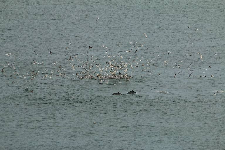
Warm water anchovies and sprat are tempting pods of dolphins, fin whales and seabirds close to the south coast this week, with feeding frenzies reported in outer Cork harbour.
An estimated 50 to 60 dolphins have been sighted by several eyewitnesses off Myrtleville and Fountainstown and Roche’s Point over the past week.
The marine mammals have been joined by kayakers who have filmed the marine mammals flipping and jumping as they tuck into the “bait balls”.
“We’ve never seen dolphins in such large numbers before at this time of year,” Donal Kissane of Myrtleville said.
“They are particularly close at high tide, and it has been wonderful to watch,” Mr Kissane said.
Carrigaline resident Derek McGreevy photographed the pods from outer Cork harbour and said he estimated there were 50 to 60 common dolphins at times, with gannets competing for the fish.
Dolphins this morning feeding on a bait ball of fish at fountainstown cork @echolivecork @CorkSafetyAlert @CorkHarbourWX @IrelandAMVMTV @WildlifeMag @whalesorg @IrishTimes @IrishSunOnline @irishexaminer @RTEOne @WILDLIFEP pic.twitter.com/J5isa2tGdk
— Derek 1968 (@1968_derek) December 2, 2020
The shoals of tiny fish are also drawing in fin whales off the south-east coast, with almost daily sightings of the second largest creature on the planet, according to Padraig Whooley of the Irish Whale and Dolphin Group (IWDG).
The abundance of anchovies – a warm water species with higher value now, used in pizza toppings and pasta dishes – has been described as “astonishing” by Dr Kevin Flannery of Dingles’s Mara Beo aquarium.
Small numbers of anchovies have been identified in Irish waters before, with the first record being off Ventry, Co Kerry, in 1870. The fish also appeared off west Cork last January.
“We thought of them as vagrants, whereas this past week has seen astonishing numbers,” Flannery said.
The Marine Institute said that it was aware of anchovies appearing in these waters in small quantities since 2003, and has identified them up as part of its periodic groundfish surveys.
Mr Whooley said that the IWDG had received sighting reports of marine mammals this week extending from Kinsale to Roche’s Point to Myrtleville and up the river Suir estuary.
“It’s not unusual for this time of year, but it is still wonderful that people can see them so close to the coast, and from their houses in Dunmore East,” he said.
At least 1,000 tonnes of anchovies landed into Dingle last week were sent to fish meal, as there are no markets for anchovies in Ireland.
The IWDG has criticised this, stating that there is “no excuse for removing the base of our inshore food chains”, which could have long term catastrophic impacts on entire ecosystems.
Minister for Marine Charlie McConalogue is currently appealing a recent High Court judicial review which overturned a ban on trawling by vessels over 18 metres inside the six-mile limit.
Health of Caribbean Coral Reefs Threatened by "Aggressive Alga"
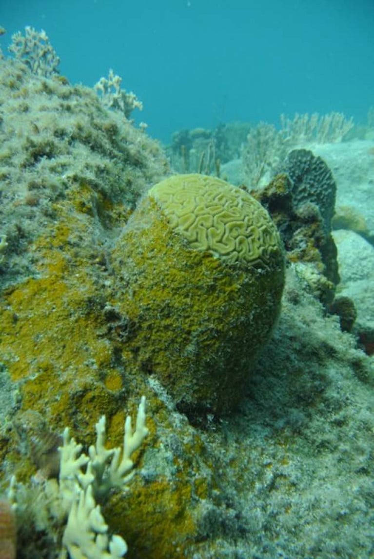
Coral reefs are under pressure from hurricanes, pollution, bleaching and global warming, and scientists have now confirmed the extent of the threat from an aggressive alga.
The algae, known as peyssonnelid algal crusts (PAC), are colonising reefs in the Caribbean at such an aggressive rate that they are interfering with the reef’s natural ecosystem, according to new research.
Marine biologists from the University of Oxford, California State University Northridge and the Carnegie Institution for Science who have been studying the issue for four years describe the extent of the threat in the Scientific Reports.
The golden-brown, crust-like alga is rapidly overgrowing shallow reefs, and has been described as an “ecological winner” by Dr Bryan Wilson of the University of Oxford’s department of zoology.
“It aggressively occupies any vacant space on the reefs, rapidly overgrows and kills live corals, prevents free-swimming coral larvae from settling on the benthos and becoming adult colonies, and is unaffected by the regular destructive hurricanes that sweep through the area,”he says.
‘It is also seemingly resistant to grazing by fish, and as far as we know, is only fed upon by a single creature, the black spiny urchin (Diadema antillarum),”he said.
The spiny urchin was once abundant in the Caribbean, but was effectively wiped out in the 1980s by a mysterious disease, he says.
“Our research has initially looked into the microbiology of PAC and compared it with that of close relatives (the crustose coralline algae, or CCA) which are known to stimulate the recruitment of coral larvae to reefs,”Dr Wilson says.
A key finding was that the PAC alga manages to inhibit the growth of beneficial marine bacteria which otherwise produce chemical compounds that attract coral larvae to the seafloor.
This means that reefs colonised by the alga are unlikely to host corals again.
The alga is described as having a “dark brown and dirty orange veneer” which stands out among the white sands and light greens, pinks, yellows and other colours that make up the reef.
The scientists say it is unclear if PAC is made up of one algal species or several, and they don’t know what is causing its rapid spread – but describe it as an “alarming trend”
They say that the next stage of their research will be to unravel the alga's “complex physiological mechanisms for this ecological success”, through studying its genome. Ultimately, they say they “hope to find ways to mitigate against this new threat”.


, and Dermot O’Kane, Head of Sales, Esri Ireland. Esri Ireland is announcing that its digital mapping system is helping DURL to prevent 13 million litres of polluted wastewater from entering Dublin rivers annually, by locating misconnected household appliances that are expelling polluted water")


 Michael Murphy Schull Harbour Sailing Club (SHSC), Eric Coogan Heineken Ireland, Mark Murphy, Commodore SHSC, Jack Allen SHSC, Carmel O'Regan SHSC, Cornelious Ndlovu, Schull Harbour Hotel Operations Manager and Derval Murphy SHSC")


