


Displaying items by tag: pontoon
Ireland’s Donegal Puts Itself On The Cruising Map
Rugged Donegal in the far northwest of Ireland is unknown territory for many Irish people whether by land or sea - and even more so for people from further afield writes W M Nixon. Yet for people who live in this picturesque but challenging region, it’s the hub of the universe, and for Donegal-located sailing enthusiasts, it can be a cruising paradise.
This was brought home to the rest of us at the recent Irish Cruising Club prize-giving, when the Glengarriff Trophy for the best cruise in Irish waters went to Dr Paul McSorley, who sails from Lough Swilly. Despite 2015’s mixed weather, he made a very detailed cruise of the Donegal coast with his daughter Eimile in the 27ft International H Boat Wild Cat. While the H Boats were developed in Finland as a fast weekend cruiser with genuine race potential (they’re now an International Racing Class), it’s unlikely that designer Hans Groop envisaged them cruising the monumental Donegal coast with its challenging location on the Wild Atlantic Way.
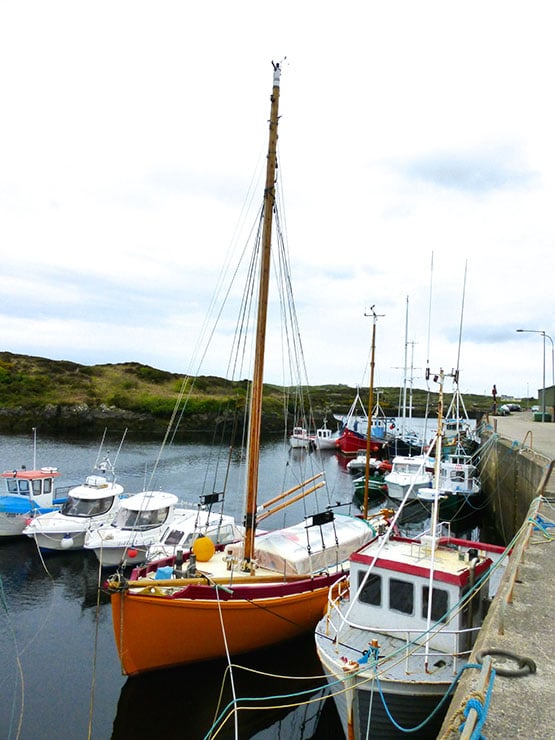
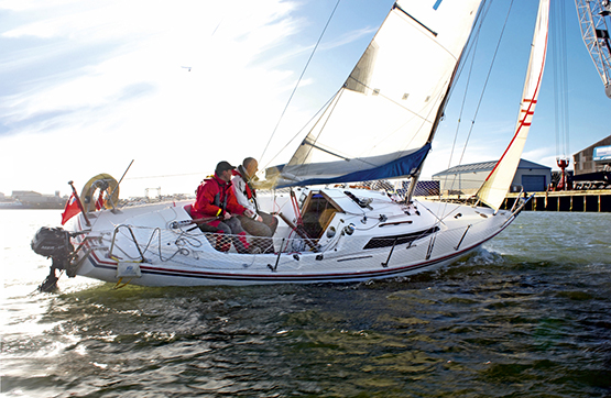 An H Boat in cruising mode. Paul & Eimile McSorley’s cruise in Donegal in 2015 with with the H Boat Wild Cat was awarded an ICC Trophy
A Land Apart – Donegal is Ireland’s ultimate cruising challenge
Yet on a good day, you could see resemblances between the myriad of islands on the Finnish coast and the maze of islands north and south of Arranamore between Dawros Head and Bloody Foreland, the area on which Wild Cat’s cruise was concentrated. The difference, of course, is the tide. But Donegal aficionados reckon that the tide adds a special spice in which the Baltic is woefully lacking……
Whatever, there’s no doubt that Donegal is a special place for many cruising folk, and in recent days the ever-curious Norman Kean and Geraldine Hennigan of Courtmacsherry, who edit the Irish Cruising Club Sailing Directions, have been in Donegal sussing out welcome new developments. In a sense, it was something of a home-coming, for when Norman first came from Scotland to settle in Ireland to work in a chemical plant in Derry, Lough Swilly Yacht Club became his home base, and it was a cruise from there to the Faroes in an own-built Sadler 25 which first put him on the cruising map.
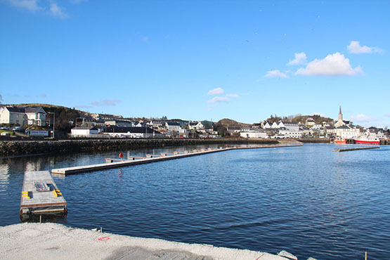
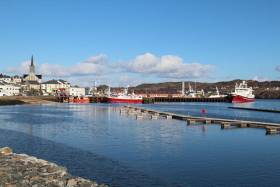
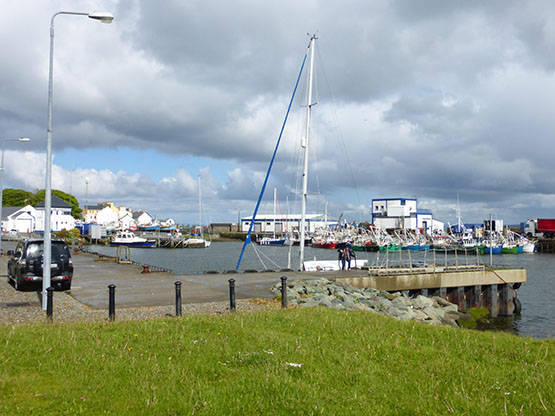
This is the start of something very worthwhile – the first pontoon berths in place in Killybegs in Donegal last week. Photo: Geraldine Hennigan
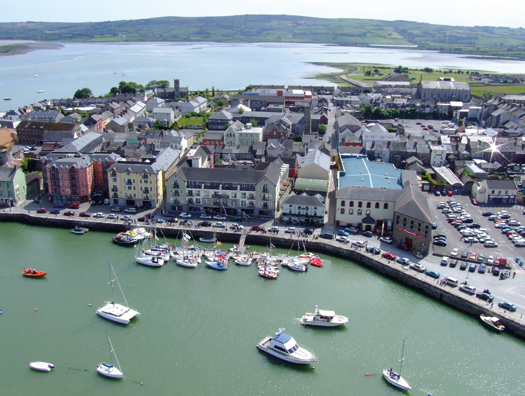
In Donegal in late February 2016, they found that the further you go south, the more promising are the developments. Best of all is the mighty fishing port of Killybegs on the south coast facing into Donegal Bay, a wonderful natural harbour for a bustling place which is said to be a town of 23 millionaires. For although not everyone does well in the fishing, some busy and innovative types do very well indeed.
For quite some time there’s been talk of the provision of pontoon facilities in Killybegs, but for 2016 Donegal County Council - where Cathal Sweeney has become the enthusiastic harbour engineer - have just gone ahead and done it with a minimum of fanfare, installing a 63-berth pontoon setup with plenty of room for expansion. (As first reported by Afloat.ie in March 2013). The pontoons were supplied and fitted by Oliver Shortall's Inland and Coastal Marinas Ltd of Banagher in County Offaly.
At present it’s called a “Small Craft Harbour”, which at first you might think reflects the reluctance of local authorities, the further north you go in Ireland, to describe a new amenity of this type as a “marina”. A case in point is Ardglass in County Down where the excellent little marina – one of the greatest boons to East Coast cruising – is still referred to as the “Phenick Cove Boat Park”.
On the other hand, Cathal Sweeney sounds a no-nonsense kind of guy, so maybe he won’t describe the very welcome new facility in Killybegs – which will transform Donegal as a cruising ground in providing a convenient base where a boat could be confidently left with good if distant communications with the rest of the country – as a marina until it has the full shoreside facilities.
Then the cruising options from Killybegs have been improved too, as to the westward a fine big pontoon has now been provided at the west pier in the lovely inlet of Teelin right beside the majestic cliffs of Slieve League. But then as we head north along the massive Atlantic seaboard, proper facilities are sparse enough, though in the case of both Burtonport and Bunbeg, it’s surely only a matter of time before a proper recreational-use pontoon or two gets installed.
Bunbeg on Donegal’s northwest corner is a little port which would benefit from a modest pontoon facility. Photo: W M Nixon
Cruising Donegal’s north coast, it still remains a source of wonder and delight that Tory Island now has a proper pier, albeit a tiny one, at which a cruising yacht can confidently overnight. And further east we hear that the most sheltered anchoring spot on the entire north coast, Fanny’s Bay on the west side just inside the entrance to Mulroy Bay, is a real possibility for a small marina facility.
Nevertheless in cruising Donegal, your first requirement is for your vessel to have her own fully operational and very substantial ground tackle, for apart from this being the seamanlike approach, the choice of anchorages which opens up when you know you’ve an anchor which will hold, and a windlass which will retrieve it, is almost boundless.
After many years, the shoreside cohesion of Fahan Marina on Lough Swilly with its landward neighbourhood south of Buncrana still seems a long way off. Photo Kevin Dwyer/Courtesy ICC
In the northeast of this enormous county of Donegal, there has of course long been a convenient if somewhat tide-ridden pontoon at Rathmullan on the west shore of Lough Swilly, but across-lough at Fahan, the marina – the great white hope of Donegal sailing – continues in a sort of semi-functional limbo, an unfinished, disconnected piece of work which nevertheless gives enough hint of what might be, if only someone could find a way through various legal and commercial impasses.
The berthing facility at Bunnagee near Culdaff took a battering in the winter storms. Photo: Geraldine Hennigan
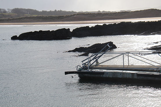
Storm damage to one of the Bunagee pontoons. Photo: Geraldine Hennigan
Up to the north of Inishowen, what was hoped to be a “marina” at the lovely little bay of Bunagee at Culdaff has seen its pontoon damaged in winter storms, for even in summer this is a restless if attractive anchorage. But on the east coast of Inishowen the Greencastle-Moville area has seen significant improvement with summer harbour for Moiville Yacht Club close south of Greencastle, where the main harbour itself has seen work resumed on some improvements.
Greencastle is a fishing port where occasionally working boats and leisure craft can become very crowded……Photo: W M Nixon
 ….but immediately south of Greencastle this new pontoon facility provides a summer berth for local craft. Photo: W M Nixon
The new Greencastle pontoons looking east across Lough Foyle. In time, an additional sheltering pier may make this a more attractive proposition for visiting cruising boats. Photo: W M Nixon
So Donegal calls. It may get some of the roughest weather in Europe, but when summer comes to stay for a week or two, it’s a cruising paradise.
Talk of Youghal Marina is 'Premature' – Pressure Group
'Talk of a Marina in Youghal is just talk', says Martin Finn of Youghal Maritime Development Group. Currently, there are no visitor moorings, no landing jetties, no berths and only one of the five slipways is still usable. Here, the pressure group spokesman responds to Afloat's report of much needed pontoons for the south coast harbour and gives an update on marine leisure facilties in the County Cork town.
Youghal is one of the oldest ports in the country, with a history dating over 1,000 years. Still today Youghal is working port, immediately adjacent to the sea and offering all tide access to smaller shipping. Youghal is also a fishing port of repute, and combined with its position in a resort town it is popular with day fishers as well as the local fishermen supplying its restaurants. That same resort location, and access to the beautiful Blackwater river, mean that Youghal is popular with leisure sailors of all types; and it would make a stunning location for a new marina development. This would serve local needs but also open up the whole South Coast of Ireland as a cruising route - a route which is currently unconnected between Cork Harbour and Dunmore East.
None of this is new. It has been said before, and repeated in numerous policy statements from Local, Regional and National bodies. Yet the marine facilities of Youghal, so often promised or planned or noted as essential - have never been given the investment they need. It is a sad fact that for the last few decades have only been marked by slow deterioration. Today, though it’s a disgrace to have to admit it, even the most meagre of Ireland’s harbours can offer facilities greater than our own. At present this fantastic town and beautiful harbour, so well positioned, can offer a visitor mooring to not a single boat. There are no visitor moorings, no landing jetties, no berths and only one of the 5 slipways is still usable. Talk of a Marina is just talk.
With this backdrop, we formed Youghal Maritime Development Group as a pressure group of citizens who are simply not sanguine to leave the deterioration to continue. We know that leisure maritime development is both a huge opportunity and an essential ingredient in the tourism offering for this area – without it the economy of this region will be forever restricted.
Who Deserves Our VotePosted by Build a Marina in Youghal on Monday, 12 October 2015
And so we have worked quietly for 18 months to cut through the myths and rumours, to research the history and to understand the issues which have stood in our way for so long. Building from this we have built a consensus amongst representatives of local maritime leisure users, fishermen, tourism, commerce and elected officials. We have drawn up a 6 stage plan of projects which we believe will create the facilities that this area needs. It should be noted that all of these are envisioned as public amenities, for the good of Youghal and this area. We also created a Facebook page (Build a Marina in Youghal) to act as a guide to our ultimate destination and to attract public interest and support. This support has been forthcoming and virtually unanimous. And the support has already reached such levels that we are able ask questions and press for results from the Officials who hold the purse strings. We have been afforded the opportunity to present our findings and recommendations to all levels of government over the last few months. We have been pleased with the positive responses we’ve received – but as yet no firm commitments.
Rumours have spread recently of imminent developments, the first substantial investment in Youghal’s marine infrastructure in a generation. We’d love to think that these rumours are true and we are working to make it so. But we believe that such rumours are, as yet, premature. Our case is being heard, and it's undeniable. We will continue to drive for development here in Youghal, and hope that first fruit of our efforts will come soon.
Martin Finn
On Behalf of
Youghal Maritime Development Group
#blatimoreharbour – The new Baltimore harbour pontoon that was first installed in February and later removed is now back in situ for the coming season. Tweeters have sent us the latest photos from the West Cork harbour above. Afloat.ie first published news of the landing pontoon and Gangway to aid boating visitors last February.The facility is popular with aquatic tourists and local sailing club members alike.
More on the sailing and boating wonders of West Cork here.
Baltimore Harbour Landing Pontoon & Gangway to Aid Boating Visitors & Aquatic tourism
#baltimore – First pictures from Baltimore Sea Safari marine company show the West Cork village's smart new central pontoon and gangway being put in place in the inner harbour. The new Baltimore harbour facility will be beneficial as a landing place for visiting boats.
And it's sure to be useful to the Optimist dinghy class when 160 gather at Baltimore Sailing Club for the mid–term school break next week.
More on the sailing and boating wonders of West Cork in WM Nixon's blog here.
New Marina For Arklow, County Wicklow

#arklowberths –In a further boost for marine lesiure and the necklace of Irish marinas around the coast, the 'Garden County' has announced 20 new berths for Arklow Harbour. It's a bid, says Arklow Harbourmaster Paul Ivory, 'to generate tourism and providing additional berthing facilities for the Arklow area'.
Ivory expects the new facility, built by Irish firm Inland and Coastal, to open before the end of the year.
It's another berthing option that follows on the successful opening of the 200–berth Greystones Harbour Marina in April 2013.
Commissioning work is still taking place in Arklow (see pontoon layout above) and rates have yet to be calculated by Wicklow County Council, who now operate Arklow Harbour.
The Marina is located in the Dock at Arklow, which has been recently dredged to an average depth of 3.0m Chart Datum, acccording to Ivory.
The new pontoons have the following berth capacity; 4 x 10m vessels on 7.5m long berths and 16 x 12m vessels on 9m long berths.
Further details are as follows:
General:
− Wheelchair accessible gangway
− Rolec service pedestals for 16amp electricity supply with smart card metering
− Fresh water taps at each pedestal
− Safety ladders and lifebuoys fitted
− Security gate at gangway
− No toilet, shower or laundry services available yet
− Price of berths to be published soon
Technical:
− Built by Inland & Coastal Marina Systems Ltd.
− Walkway units with mooring cleats, 500mm freeboard
− Berth spacings are as per Pianc (The World association for Waterborne Transport Infrastructure) guidelines
− Hardwood timber fenders
− Glassfibre Reinforced Concrete (GRC) decking
− Floatation provided by GRC encased expanded polystyrene floats, minimum GRC skin thickness 10mm
Cruise to Visit River Liffey's New Pontoons in Dublin City
#dublinport – Dublin Port Company have installed new permanent pontoons on the River Liffey at North Wall Quay (beside the O2). Dublin Port Company, Sail Training Ireland and the Irish Sailing Association have linked up with the Cruising Association of Ireland's yearly Liffey Cruise to create the Dublin Port Parade of Sail on Dublin Bay on the weekend of 27 & 28 September 2014.
The Cruising Flotilla coincides with Dublin Port Vintage Car Rally, 27th - 28th of September. The boating community isinvited to take part in a flotilla to officially open these pontoons, which are now available for use by vessels wishing to visit the Capital city.
More information on the cruise HERE.
A core Dublin Port aim of the cruise is to protect and develop Dublin's heritage as a port and maritime city. By partnering with the Cruising Association of Ireland and the Irish Sailing Association in this initiative it is hoped to further increase the level of boating activity on the River Liffey and to highlight the availability of the new North Wall Quay pontoons for visiting vessels.
Cruising Flotilla Itinerary
All boats gather in Dublin Bay Saturday 27th September
Parade of Sail up the River Liffey for a bridge lift
Over-Night berthing on the new pontoons
Reception with welcome drinks and buffet on board the Cill Airne Boat-Bar and Restaurant
Music entertainment including a Harpist
Departure on Sunday morning or afternoon
Tickets for buffet BBQ €20 per person.
Charlie Murphy, Communications Manager at Dublin Port announced "The purpose of this event is to promote the River Liffey as a destination for the boating community. The river has so much potential as a recreational resource for Dublin City. We hope that this event will increase awareness among the boating community that the River is a destination that welcomes them"
Vintage Car Rally
This event takes place all weekend and will see an array of vintage vehicles descend on Dublin Port for the annual Vintage Car Rally. There will be vehicles on show, transport sales and exhibition stalls; a vintage bus service touring Dublin Port. Funds from this event will go to support the excellent work undertaken by Barnardo's Ireland. Ticket prices: €4 for kids, €8 for adults & €20 for a family. More here.
Sail Training Ireland (S.T.IRL.) is the National Sail Training Charity, with President of Ireland, Michael D. Higgins as our Patron. The aim of S.T.IRL. is to provide access for Irish youths to sail training voyages at sea, regardless of background, social or financial constraints or ability. Since 2011 over 500 youths have undertaken voyages as a result of our work. Dublin Port Company and Dublin City Council are our main supporters. Members include: The Irish Naval Service, NMCI, Ports of Dublin, Drogheda, Cork and Galway, Spirit of Oysterhaven Trust. S.T.IRL. is a member of the ISA.
The Cruising Association of Ireland is a voluntary ISA-affiliated organisation. Working with the ISA, the ICC and other related organisations, it represents the interests of cruising sailors in Ireland, and promotes cruising among the wider sailing community via www.cruising.ie. The Liffey Cruise has been a regular feature of its calendar on the East Coast.
Dublin Port Company and Dublin City Council have signed an agreement with Sail Training Ireland to develop a local Dublin-based Sail Training Programme as a legacy to their partnership formed during the 2012 Tall Ships Festival. This is built on a platform of regenerating the River Liffey as a resource for the community of Dublin, integrating the community of Dublin and Ireland with the Port, the sea, maritime activities and maritime industries.
Dungarvan Harbour Sailing Club 30–Berth Pontoon Will Attract Visiting Boats to Waterford

#tourism – A new Dungarvan pontoon facility to provide short term temporary berthing on the Copper coast in West County Waterford has been opened. The facility opened by Dungarvan Harbour Sailing Club will provide berthing for approximately 30 berths on the West Waterford coast. The new facility replaces an older interim structure which had been in place since the early 1990s.
The facility is for Club members on a daily fee basis as well as access for visiting boats. It is expected the latter aspect will support the development of marien tourism on the West Waterford coast.
The facility was opened on 11th of May the Minister for Agriculture, Food and the Marine. Simon Coveney T.D.
Speaking at the opening, the Commodore of Dungarvan Harbour Sailing Club, Joan Moloney, said "This is a proud day for sailing in Dungarvan as it represents another important development in the 68 year history of the club. The modernisation of the pontoon facilities will provide safer boat access for families and sailors and will support tourism development in the town". She then went on to thank those in the club who have worked tirelessly to bring the project to fruition.
Moloney thanked Dungarvan Town Council and in particular the unstinting efforts of Joe O'Flaherty the recently retired Town Clerk and Eoin McGarry of McGarry Construction was also praised for his effective and efficient installation of the facilities together with the suppliers Inland and Coastal. During the project a late technical hitch prevented dredging work being undertaken in addition to the pontoon installation.
#marinas – It was only fifteen years ago that ocean voyager Paddy Barry set off in his much-travelled Galway Hooker St Patrick for a cruise round Ireland. He completed it, and he also succeeded in his secondary objective of seeing if it was still possible to do the circuit almost entirely without stops at anchorages described in detail in the Irish Cruising Club Sailing Directions.
By 1998, the Ireland circuit was no big deal, so you needed this frisson of exploration to add an extra zest. After all, Rob Henshall from Fermanagh had done the circuit unaccompanied in a Laser, and also alone on a windsurfer. But cruising boats were still so relatively rare on much of the Atlantic seaboard that it had been accepted that the ICC guides were bound to have gaps, as they relied almost exclusively on the voluntary input of information.
Then too, just fifteen years ago, the absence of convenient berthing and easy shore access was something else which made the more distant coastlines unknown places. And it wasn't in just the remoter areas that you had to face this problem. Even if you could manage to get comfortably anchored or moored, the business of getting ashore at anchorages on all coastlines could still be a struggle, much exacerbated if you had children or people with impaired mobility. For many Irish harbours, the minimal comfort and convenience of a landing pontoon was still an aspiration rather than the reality.
Back in 1995, Afloat Magazine first published a comprehensive Irish Marina Guide. It had to include all the inland waterways marinas to add the respectability of numbers, for the coastal marinas were still woefully few. And in a pre-prosperity Ireland in which the very name of "marina" aroused prejudice, new projects to provide a few berths in hostile harbours had to resort to euphemisms. "Boat Park" and "Convenience Berthing" and "Disabled Landing" were marinas by any other name. It was a case of whatever you're having yourself, any name you like, but just let's get on with it and have one, and try a taste of boating in late 20th Century style.
But now, things have certainly changed since the days you could cruise round Ireland and stay overnight in "unknown" anchorages. And a very encouraging number of harbours and anchorages have acquired the convenience and safety of a proper pontoon, where at the very least your crew can easily access your tender, and usually you can bring the boat alongside for short visits and the ease of getting gear, equipment and people directly on board.
Perhaps most interesting of all, however, is that marinas of all sizes - and happy to call themselves marinas - have appeared on nearly all coastlines, and sometimes in the most unexpected places, such that the Afloat.ie Marinas Guide currently lists 67 establishments, and we expect that number to steadily increase as the economy slowly revives. The realization of this enormous and welcome transformation is clearest when you study the recently-published 13th Edition of the Irish Cruising Club Sailing Directions for the South & West Coasts of Ireland.
When West Cork-based Norman Kean took over the job as Honorary Editor of the ICC's two pilotage books, he set out to make a round Ireland cruise like that of St Patrick in 1998 using only unknown anchorages, into an impossibility. It was a massively ambitious project, as Ireland's coastline measured in detail can be something like 4000 kilometres long.
But this Courtmacsherry Cyclone, ably assisted by his wife Geraldine, has worked miracles of research and productivity. Yet even by Norman Kean's high standards, this latest 13th Edition of the S & W book is a game changer, a masterwork, one of the best in the entire world, 356 pages of high quality information well amplified with clear plans, and profusely illustrated with photos all of which are informative and many - particularly the aerial ones by Kevin Dwyer - are beautiful evocations of an utterly lovely coastline which just occasionally we might too easily take for granted.
The previous 12th Edition was published in 2008, so obviously the difference is that projects which had only just been put in hand in the Celtic Tiger years are seen in this new book at various levels of fruition. If you find the memories of that crazy time depressing, cheer up. This book should encourage you to think that some lasting good – as with our excellent new motorway system – came out of that era of shared lunacy. While property values may have gone with the wind, the improvements to the coastal infrastructure are of lasting benefit which we can begin to enjoy properly as the economic wheels start to turn again.
Apart from its usefulness as an aid to navigation and pilotage, the 13th Edition a fascinating read in itself, as it takes you along two of our most interesting coastlines, and we get an insight into the way the various harbour authorities are seeking to embrace new opportunities. In several cases, it is County Councils which have been prepared to stick their heads above the marina development parapet.
High water in Dungarvan Harbour, and an impressive fleet is gathered at the sailing club's pontoon. Photo: Donal Walsh
For some years we saw on the east coast how Wicklow CC got dog's abuse from trying to do something useful with Greystones Harbour. But now that the marina is finally up and running with boats coming in and adding new life and interest to the place, it doesn't seem such a crazy idea after all.
Last week in this blog we were discussing how Wexford County Council had brought vision and energy to the development of Kilmore Quay on the south coast, which these days is a national pace setter showing how best to combine different uses and sensibly utilise space. It was certainly a new era when the marina there was opened by all the top honchos in local authority and government nearly two decades ago. We probably still had a Department of the Marine back then, and it was such a time of hope, with the buzz at Kilmore so good, that though my mother-in-law's daughter and I had gone down expecting to return that same evening, it was well into the following afternoon when we reappeared at Command HQ.
Further west along the south coast, the new book has an intriguing aerial photo by Donal Walsh showing high water in Dungarvan Harbour, and the club pontoon well filled with yachts in regatta mode. For sure, it's a bit different when the tide goes out. But it's a useful reminder that the traditional perception of the coast between Waterford Estuary and Cork Harbour as a cruising desert is a complete nonsense.
Kinsale is almost a cliché for the perfect cruising port, but the 13th Edition makes us look at it anew with a Kevin Dwyer aerial pic which I hand't seen before, taken from due south. Properly speaking, West Cork is anywhere west of Cork city. But in reality West Cork doesn't properly begin until you're west of the Bandon River which flows through Kinsale Harbour. This photo says it all – the way that the crowded little town of Kinsale on the northeast side is a bustling cosmopolitan port, yet all you have to do is cross the bridge and immediately you're slowing down to West Cork speed and the relaxed atmosphere of Castlepark which – very welcome for families – even has its own neat little south-facing beach along a short sandy lane.
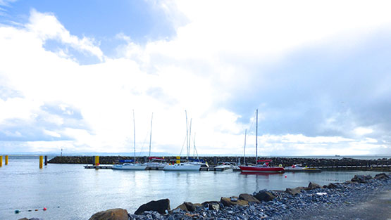
A brisk norwest wind makes things lively at Baltimore's crowded pontoon. In such conditions, there's much better shelter at the pontoon across at Sherkin Island. Photo: Edi Keating
Further west, busy Baltimore has battled for years to deal with conflicting demands on its limited public waterfront space. While the pontoon gives heroic service, in a brisk nor'wester it can verge on being very uncomfortable, and the photo by Edi Keating usefully illustrates that when conditions are like this, a sensible cruising crew will go over to the shelter at the Sherkin Island pontoon.
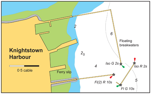
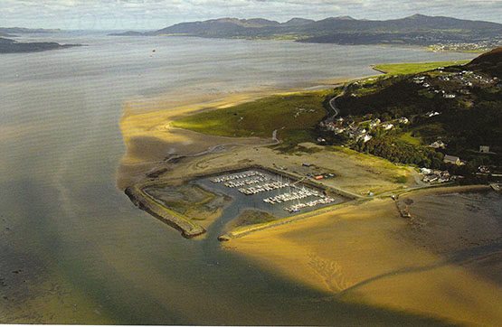
Around on the Kerry coast, there has been much activity with the floating breakwaters of a marina for Kerry County Council at Knightstown on Valentia Island. When eventually finished, it could have hundreds of berths, but for now it is considered permanent enough to be included in the new ICC book, and here it is for all to see – the longest landing pontoons in Ireland.
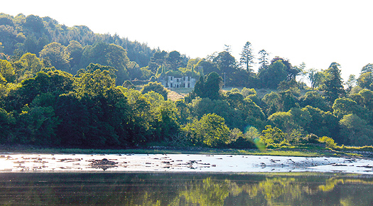
Paradise almost lost – the ruins of Paradise House are the last relics of ould dacency above the anchorage in the Fergus River Photo: Geraldine Hennigan
The anchorage at Paradise. Lt William Henn brought his hundred foot America's Cup-challenging steel cutter Galatea in here. Photo: Geraldine Hennigan
With its sluicing tides and acres of gooey mud, the Shannon Estuary is not to everyone's cruising taste, but Norman Kean was determined to do it from end to end. Among the islands at the mouth of the Fergus river on the north shore of the great estuary he found Paradise north of Kildysart – the remains of Paradise House, family home of 1886 America's Cup challenger William Henn, and the sweet little anchorage below it where the gallant Lieutenant Henn brought his hundred foot cutter Galatea for a visit.
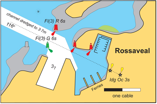
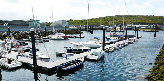
The marina at Rossaveal is already popular Photo: Geraldine Hennigan
Up in Galway Bay, did you know there is now a marina at Rossaveal, that uber-busy Aran Islands ferryport and fishing harbour on the threshold of Connemara? Well, when they were doing the most recent re-development of Rossaveal, somebody did a bit of thinking outside the usual narrow box, and the result is a very handy little facility which already looks to be well filled, but there's room for more, and it's a very useful location.
The flotilla gathered at Inishbofin inner quay includes (left to right) the Arctic voyaging Arctic Fern (John Coyle), Dr Michael Brogan's ketch-rigged Galway hooker Mac Duach, the high latitudes cruiser Northabout (Jarlath Cunnane) and the Vancouver 28 Colla Voce (Pat Lavelle). Photo: Geraldine Hennigan
Of course, the dictating factor on any coastal marina is dealing with the ever present tides, but every cruising enthusiast likes to take a photo of their favourite little quayside in the convenience of high tide on a summer's day. Norman Kean has indulged the ICC's active western membership with a happy snap of some very distinguished boats rafted up at high water at the inner quay at Inishbofin, with Day's pub only a matter of yards away, and all well with the world until the tide falls. Even then, it's not the worst place to dry out alongside, and you'll note that Pat Lavelle's Vancouver 28 Colla Voce is a Bofin regular, and has a leg fitted.
Rosmoney's brand new pontoon. The boat is a 17ft French-designed pram built by Jarlath Cunnane Photo: Rory Casey
On up the coast, the new pontoon at Rosmoney Quay among the islands at the head of Clew Bay beside Mayo SC's well-filled anchorage was commissioned too late to be included in the new ICC book. But we have it here just to show that sometimes it is possible to draw level with the Kean machine, even if you never actually get ahead. MSC Commodore Rory Casey says that it's such a success they're going to have to be very careful that people don't hog it, but instead clear out just as soon as they've completed the essential tasks it's designed to facilitate.
Sligo has been a port seldom enough visited by cruising yachts. It's way off the beaten track if you're determinedly on the round Ireland circuit, and the two main sailing centres in the area – Rosses Point and Mullaghmore – have sometimes uncomfortable anchorages, Mullaghmore being open to the north, while the Rosses Point moorings are very tide rode.
The pontoon in the heart of Sligo provides excellent access to an interesting town Photo: W M Nixon
But now there's a pontoon in Sligo itself, which is so handy that Darryl Hughes, the owner of the beautifully-restored 1937 43ft Tyrrell ketch Maybird, bases himself there when he makes his annual visit to the Yeats Summer School at the end of July. He's still the only Yeats aficionado who sails to the Summer School, but it's early days yet – the pontoon is still thought of as new.
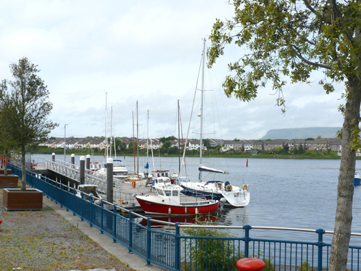
Up the coast at Mullaghmore, they've worked a little miracle. The harbour is very much a drying basin, and the anchorage off it can be mighty lumpy. But with some judicious use of quite a lot of rock armour, they've created snug little corner just outside the harbour mouth and installed a fine big pontoon. The depth alongside may go down to 0.6 metres on the lowest tides, but most of the time most boats can nip alongside for convenient embarkation and unloading, and it's a major convenience and safety addition to the facilities of the harbour.
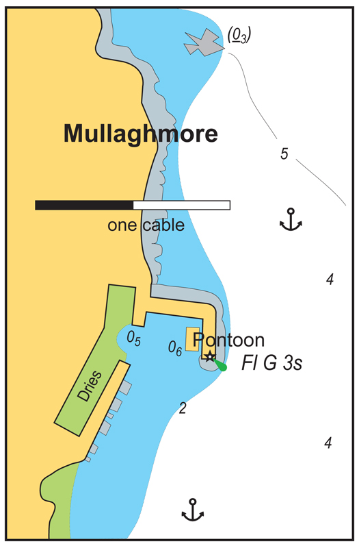
The new pontoon just outside the entrance to Mullaghmore Harbour is a boon for all boat users
From the head of Donegal Bay right round to Lough Swilly, there are some fine harbours, but there isn't another dedicated recreational boating pontoon until you get to Rathmullan in Lough Swilly, with Fahan Marina just across the way. It's only a matter of time before something is installed in Killybegs, and Burtonport up in that lovely area of The Rosses would be strategically useful and the logical place for some facility, ideally one where a boat could be left.
However, up there in that remotest corner of the remote northwest, one of my most convenient crew changes was done at the little fishing port of Kincasslagh. It must be the nearest port to Carrickfin airport, and that's very useful for crews linking to or from Dublin, for this place is cut off by the mountains from any direct roads. Time passes easily as you get up to speed with all the news of The Rosses at Iggy's bar in Kincasslagh, and if there's further delay you can always go and say hello to Daniel O'Donnell who lives nearby. He can tell you more Daniel O'Donnell jokes than anyone else, and tell them better too.
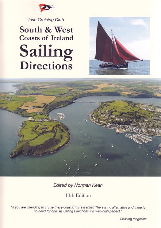
The 13th Edition of the Irish Cruising Club Sailing Directions for the South & West Coasts of Ireland is on sale at €29.95 from all good chandlers or bookshops, or direct from www.iccsailingbooks.com
Comment on this story?
We'd like to hear from you! Leave a message in the box below or email William Nixon directly on[email protected]
WM Nixon's Saturday Sailing blog appears every Saturday on Afloat.ie
Follow us on twitter @afloatmagazine and on our Afloat facebook page
Afloat's Marina Guide Online
We're keen to get reader input on their marina experiences too so we can build a comprehensive picture of the Irish coastal marina and pontoon scene. Can you update our readers with extra information? If so please leave your comments in the box provided for each marina/pontoon listed.
Five miles beyond Foynes Island on the Shannon Estuary in County Limerick is Deel Boat Club that provides a club pontoon and moorings.

Although primarily a fishing port Dunmore East harbour also offers facilities to visiting yachts. From June through August 2013 pontoons will be available in the harbour for visiting yachts and the local club will help with possible swing moorings.
Prior to arrival contact the Harbour Master Harry McLoughlin
Harbour Administration Building,
South Pier,
Dunmore East,
Co. Waterford.
Harbour Master Mobile
Phone Number: 087/7931705
Telephone Number: 051/ 383166
Fax Number: 051/383607
E-mail address: [email protected]


, and Dermot O’Kane, Head of Sales, Esri Ireland. Esri Ireland is announcing that its digital mapping system is helping DURL to prevent 13 million litres of polluted wastewater from entering Dublin rivers annually, by locating misconnected household appliances that are expelling polluted water")


 Michael Murphy Schull Harbour Sailing Club (SHSC), Eric Coogan Heineken Ireland, Mark Murphy, Commodore SHSC, Jack Allen SHSC, Carmel O'Regan SHSC, Cornelious Ndlovu, Schull Harbour Hotel Operations Manager and Derval Murphy SHSC")


