


Displaying items by tag: Europe's Lost Frontiers
Celtic Voyager Explores Irish Sea’s Lost landscapes
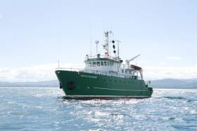
#MarineScience - An Irish research team from IT Sligo and University College Cork recently joined the ‘Europe’s Lost Frontiers’ project to explore the extensive submerged landscapes in the Irish Sea aboard the Marine Institute’s Celtic Voyager research vessel research vessel.
Following the last Ice Age, large areas of habitable land were inundated following climate change and sea level rise across the world. Globally, the sea level rose around 120 metres and an area more than twice that of the modern United States of America was lost to the sea.
Beneath the waves of the Irish Sea is a prehistoric ‘palaeolandscape’ of plains, hills, marshlands and river valleys in which evidence of human activity is expected to be preserved.
This landscape is similar to Doggerland, an area of the southern North Sea and currently the best known example of a palaeolandscape in Europe. Doggerland has been extensively researched by Prof Vince Gaffney, principal investigator of the Europe’s Lost Frontiers project.
“Research by the project team has also provided accurate maps for the submerged lands that lie between Ireland and Britain,” said Prof Gaffney, “and these are suspected to hold crucial information regarding the first settlers of Ireland and adjacent lands along the Atlantic corridor.”
To provide this evidence, sediment from some 60 cores, taken from 20 sites by the RV Celtic Voyager in Liverpool and Cardigan Bays between the 21 and 25 February, will be studied by an international marine research team.
Dr James Bonsall, from the Centre for Environmental Research Innovation and Sustainability (CERIS) in the Department of Environmental Science at IT Sligo, was chief scientist for this phase of the research, and together with his CERIS colleague, environmental scientist Eithne Davis, directed operations on board the RV Celtic Voyager.
“It is very exciting,” said Dr Bonsall, “as we’re using cutting-edge technology to retrieve the first evidence for life within landscapes that were inundated by rising sea levels thousands of years ago.
“This is the first time that this range of techniques has been employed on submerged landscapes under the Irish Sea. Today we perceive the Irish Sea as a large body of water, a sea that separates us from Britain and mainland Europe, a sea that gives us an identity as a proud island nation. But 18,000 years ago, Ireland, Britain and Europe were part of a single landmass that gradually flooded over thousands of years, forming the islands that we know today.
“We’re going to find out where, when, why and how people lived on a landscape that today is located beneath the waves.”
Key outcomes of the research will be to reconstruct and simulate the palaeo-environments of the Irish Sea, using ancient DNA, analysed in the laboratories at the University of Warwick, and palaeo-environmental data extracted from the sediment cores.
The studies will be of immense value in understanding ‘first’ or ‘early’ contact and settlement around the coasts of Ireland and Britain, but also the lifestyles of those people who lived within the inundated, prehistoric landscapes that lie between our islands and which have never been adequately explored by archaeologists.
The Celtic Voyager and the Marine Institute’s expertise were provided to explore the extensive submerged landscapes, where marine core samples were taken. Technical support setting up the seabed survey and navigation systems was also provided by members of the DCCAE-funded INFOMAR team, who specialise in bathymetric mapping and geophysical survey.
This research survey was carried out with the support of the Marine Institute, funded under the Marine Research Programme 2014-2020 by the Irish Government.
Europe’s Lost Frontiers is an ERC-funded Advanced Grant project based at the University of Bradford. Aimed at understanding the transition between hunter gathering to farming in north-west Europe, the project is studying the evidence for inundated palaeolandscapes around the British coast using seismic reflectance data sets to generate topographical maps of these ‘lost lands’ that are as accurate and complete as possible.
Environmental data from these areas is then being used to reconstruct and simulate the palaeo-environments of these landscapes using ancient DNA extracted directly from sediment cores as well as traditional environmental evidence.


