


Displaying items by tag: Marine Institute

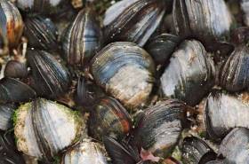
Shellfish landings — particularly brown crab and whelk — saw a significant boom in 2016 compared to previous years, with a value of €56 million to the economy.
But species such as lobster and periwinkle saw “unexpected changes in volumes” compared to 2004 levels, according to the Marine Institute’s Shellfish Stocks and Fisheries Review for 2016-2017.
“Although landings can obviously increase or decline due to changes in fishing effort or catch rates, the scale of change in some species, in fisheries that are known to have stable or increasing effort and where catch rate indicators are stable, is contradictory,” the report warns.
“Other sources of information from industry questionnaires also indicate significant differences between official landings and landings derived from estimates of catch rates, annual individual vessel landings, days at sea and individual vessel fishing effort.”
The review concentrates on cockles, oysters, scallops, lobsters and razor clams, of which the North Irish Sea fishery for the latter saw significant expansion between 2011 and 2017, in tandem with a decline in stock.
Earlier this year, consultations were held on proposals for new conservation measures to protect razor clams in the North Irish Sea and brown crab in Irish waters, as previously reported on Afloat.ie.
As for cockles, the main fishery in Dundalk Bay experiences variable rates of overwinter survival, resulting in a biomass that in some years “is insufficient to support a fishery”. The situation is even more serious in the Waterford Estuary.
“Continuing commercial fisheries for cockles in Natura 2000 sites [like Dundalk Bay] will depend on favourable conservation status of designated environmental features that may be affected by this fishing activity or a clear demonstration that changes to designated features are not due to cockle fishing,” the review states.
Oyster stocks, meanwhile, are “generally low in all areas, except Fenit”, prompting a need for “management measures to restore recruitment and re-build spawning stocks”.
The full review is available to download from the Marine Institute website HERE.
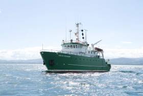
Celtic Voyager Explores Irish Sea’s Lost landscapes

#MarineScience - An Irish research team from IT Sligo and University College Cork recently joined the ‘Europe’s Lost Frontiers’ project to explore the extensive submerged landscapes in the Irish Sea aboard the Marine Institute’s Celtic Voyager research vessel research vessel.
Following the last Ice Age, large areas of habitable land were inundated following climate change and sea level rise across the world. Globally, the sea level rose around 120 metres and an area more than twice that of the modern United States of America was lost to the sea.
Beneath the waves of the Irish Sea is a prehistoric ‘palaeolandscape’ of plains, hills, marshlands and river valleys in which evidence of human activity is expected to be preserved.
This landscape is similar to Doggerland, an area of the southern North Sea and currently the best known example of a palaeolandscape in Europe. Doggerland has been extensively researched by Prof Vince Gaffney, principal investigator of the Europe’s Lost Frontiers project.
“Research by the project team has also provided accurate maps for the submerged lands that lie between Ireland and Britain,” said Prof Gaffney, “and these are suspected to hold crucial information regarding the first settlers of Ireland and adjacent lands along the Atlantic corridor.”
To provide this evidence, sediment from some 60 cores, taken from 20 sites by the RV Celtic Voyager in Liverpool and Cardigan Bays between the 21 and 25 February, will be studied by an international marine research team.
Dr James Bonsall, from the Centre for Environmental Research Innovation and Sustainability (CERIS) in the Department of Environmental Science at IT Sligo, was chief scientist for this phase of the research, and together with his CERIS colleague, environmental scientist Eithne Davis, directed operations on board the RV Celtic Voyager.
“It is very exciting,” said Dr Bonsall, “as we’re using cutting-edge technology to retrieve the first evidence for life within landscapes that were inundated by rising sea levels thousands of years ago.
“This is the first time that this range of techniques has been employed on submerged landscapes under the Irish Sea. Today we perceive the Irish Sea as a large body of water, a sea that separates us from Britain and mainland Europe, a sea that gives us an identity as a proud island nation. But 18,000 years ago, Ireland, Britain and Europe were part of a single landmass that gradually flooded over thousands of years, forming the islands that we know today.
“We’re going to find out where, when, why and how people lived on a landscape that today is located beneath the waves.”
Key outcomes of the research will be to reconstruct and simulate the palaeo-environments of the Irish Sea, using ancient DNA, analysed in the laboratories at the University of Warwick, and palaeo-environmental data extracted from the sediment cores.
The studies will be of immense value in understanding ‘first’ or ‘early’ contact and settlement around the coasts of Ireland and Britain, but also the lifestyles of those people who lived within the inundated, prehistoric landscapes that lie between our islands and which have never been adequately explored by archaeologists.
The Celtic Voyager and the Marine Institute’s expertise were provided to explore the extensive submerged landscapes, where marine core samples were taken. Technical support setting up the seabed survey and navigation systems was also provided by members of the DCCAE-funded INFOMAR team, who specialise in bathymetric mapping and geophysical survey.
This research survey was carried out with the support of the Marine Institute, funded under the Marine Research Programme 2014-2020 by the Irish Government.
Europe’s Lost Frontiers is an ERC-funded Advanced Grant project based at the University of Bradford. Aimed at understanding the transition between hunter gathering to farming in north-west Europe, the project is studying the evidence for inundated palaeolandscapes around the British coast using seismic reflectance data sets to generate topographical maps of these ‘lost lands’ that are as accurate and complete as possible.
Environmental data from these areas is then being used to reconstruct and simulate the palaeo-environments of these landscapes using ancient DNA extracted directly from sediment cores as well as traditional environmental evidence.
RV Celtic Voyager To Be Replaced As Part Of National Development Plan

#MarineScience - The Government’s new National Development Plan includes provision for a new marine research vessel to replace the RV Celtic Voyager, according to The Irish Times.
Marine Institute chief executive Dr Peter Heffernan says work is at an “advanced stage” towards confirmation of the project, which would see the 31-metre Celtic Voyager — which has served for two decades — replaced with a vessel of around 50 metres in length.
The new ship would serve alongside the RV Celtic Explorer, which recently underwent a major refit, as previously reported on Afloat.ie.
Refit of RV Celtic Explorer Leads to a Renewed Start in 2018
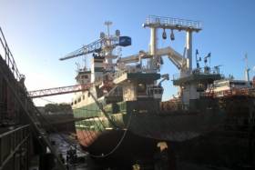
#MarineScience - Research vessel RV Celtic Explorer of the Marine Institute, is off to a renewed start in 2018, after undergoing a major refit.
The Romanian-Dutch built ship is ready to accommodate 18 scientific surveys throughout the year.
The five-year refit included an overhaul of the bow thruster and an upgrade of its DC propulsion system. The vessel's original fishing sonar was removed and a new Simrad SU92 fisheries sonar installed. The new sonar will have an increased range and resolution and a decreased noise level, which will be a huge advantage for the Marine Institute's fisheries research.
The vessel's accommodation also received an upgrade after 15 years of service with cabin floors refurbished and a new accommodation layout in the scientists cabins. The RV Celtic Explorer's refit also included painting and antifouling of the hull and complete painting of the superstructure as well as a major 60,000 hour overhaul of one of its main diesel generators .
The 65.5m vessel was in A&P yard in Falmouth, United Kingdom for the refit which started in mid in December 2017 and works were completed this month.
The RV Celtic Explorer came into service in 2003 and is designed for fisheries acoustic research, oceanographic, hydrographic and geological investigations as well as buoy/deep water mooring and ROV Operations.
Several deepwater ROV surveys will be undertaken in 2018, one led by Dr Louise Allcock from the National University of Ireland, Galway will investigate deep sea corals and sponges from a diversity of deep-water habitats.
Professor Andrew Wheeler from the University College Cork will explore and monitor cold water corals in the submarine canyons in the deep ocean and determine their sensitivity to climate change, fisheries and oil industry impacts.
A survey led by Professor Sergei Lebedev from the Dublin Institute for Advanced Studies will investigate the structure, evolution and seismic hazard of Ireland's offshore territory. Professor Lebedev's team will for the first time, deploy an array of ocean-bottom, broadband seismometers offshore, which together with existing arrays onshore will cover the entire Irish territory.
Dr Aggeliki Georgiopoulou from the University College Dublin will survey the structure and composition of the lower crust and mantle, as well as any hydrothermal activity RV Celtic Explorer off to a renewed start in 2018 at the Charlie Gibbs Fracture Zone, the largest geological fault in the northern Mid-Atlantic Range.
In 2018 the Marine Institute will also undertake acoustic surveys of Anglerfish and Megrim, Blue Whiting, Celtic Sea Herring and Boarfish on the RV Celtic Explorer. An INFOMAR-led survey will also map the physical features of the seabed in the Celtic Sea, using hydrographic techniques.
To follow the voyages of the RV Celtic Explorer, visit the Marine Institute website to track a vessel or view the vessel schedule. A virtual tour of the RV Celtic Explorer can also be accessed from the Marine Institute website at www.marine.ie
Irish Scientist Appointed Vice Chair Of International Council for the Exploration of the Sea’s Advisory Committee
#MarineScience - Dr Colm Lordan of Fisheries Ecosystems Advisory Services at the Marine Institute has been appointed as one of the Vice Chairs of the International Council for the Exploration of the Sea (ICES) Advisory Committee.
The ICES Advisory Committee (ACOM) is responsible for providing scientific advice to competent authorities in support of the sustainable management of marine resources and ecosystems in the North Atlantic Ocean. Dr Lordan will work 50% of the time in his new ACOM role and 50% in his team lead role at the Marine Institute.
Dr Lordan joined the Marine Institute in 1998 and participated in Northern Shelf and Southern Shelf demersal stock assessment working groups.
In 2003, his focus moved to nephrops stocks and developing underwater television surveys and assessment methods. Dr Lordan currently leads a team of marine scientists working on demersal fish and nephrops surveys, stock assessment and scientific advice.
Dr Lordan said he is expecting his three-year term as Vice Chair of the ICES Advisory Committee to be both busy and diverse.
“I am looking forward to getting a broader perspective on the advisory system and I hope to learn a lot about stocks, fisheries, assessments, and management challenges in areas beyond the Celtic Seas,” he said.
“I am also interested in collaborating with others to improve the quality assurance and to develop new and innovative advisory products.”
Dr Lordan was first involved with ICES in 1993, and since then has participated in 60 different ICES expert groups and chaired or co-chaired 16 working groups.
ICES has a network of more than 5,000 scientists from over 690 marine institutes in 20 countries. For more information on ICES visit www.ices.dk.
Marine Institute Summer Bursary Scholarship Scheme Opens For 2018
#MarineScience - The Marine Institute is inviting marine science students to apply for a number of work experience placements for summer 2018.
The Marine Institute Bursary Scholarship Scheme provides scholarships worth €275 per week for an eight-to-12-week placement (bursary dependant).
Scholarship recipients will be based in various locations including the Marine Institute HQ in Oranmore, Co Galway; Newport, Co Mayo and other locations and ports around the country.
The Bursary Scholarship Scheme provides valuable practical experience for students in areas of research such as marine fisheries, salmon management, aquaculture, oceanography, benthic ecology, communications and R&D.
The programme is aimed at undergraduates of universities, institutes of technology and national institutes for higher education, and is strictly limited to those who will have completed two years’ study in a relevant discipline by the beginning of June.
Previous bursars have gone on to work in the Marine Institute (including two directors of the institute), Bord Iasaigh Mhara, Regional Fisheries Boards, county councils, pharmaceutical companies and State laboratories, with some going as far afield as the EPA in Sydney, Australia and others now running their own companies.
To apply for the Marine Institute Summer Bursary Programme for 2018:
- Check out the bursary titles on offer
- Select the two bursaries that interest you most and in order of preference
- Complete the application form and return it FAO Annette Jordan, Marine Institute, Furnace, Newport, Co Mayo
The deadline for applications is Friday 9 February.
Connemara Sea Scouts Solve Mystery Of Marine Research Buoy
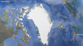
#ArcticBuoy - A marine research buoy found on the Connemara coast by local Sea Scouts recently had drifted over 6,000 kilometres across the Beaufort Sea, Arctic Ocean and Atlantic to Ireland.
The buoy, around half a metre in diameter, was found at Lettermullen by the scout troop during an exploration of their local beach.
Michael Loftus, leader of Gasógaí Mara na Gaeltachta (Connemara Sea Scouts), said they often find flotsam and jetsam washed up on the shore, which they can usually identify.
“However, little did we know that this new find would uncover a world of discovery relating to the buoy being launched from an aircraft in the Arctic Ocean and travelling thousands of kilometres to land on the west coast of Ireland.”
The Marine Institute, which works on a series of projects where autonomous instruments are deployed into the ocean for marine research, was contacted to help solve the mystery of where the red buoy came from.
“Although the buoy is not an Argo float that is typically used by the institute as part of the national Argo float programme, we were delighted to help the Sea Scouts establish that the buoy is in fact an Airborne Expendable Ice Buoy, which came from as far away as the Beaufort Sea,” said Diarmuid Ó Conchubhair of the Marine Institute.
The International Arctic Buoy Programme involves a number of different countries including Canada, China, France, Germany, Japan, Norway, Russia, and the United States.
The programme maintains a network of drifting buoys in the Arctic Ocean that are used to monitor sea surface temperatures, ice concentration, and sea level and support weather forecasting. The buoys are also used for validating climate or earth system models which inform the Intergovernmental Panel on Climate Change (IPCC) reports.
Each buoy in this programme has an identification number that is used to track its location in the Arctic Ocean using a type of satellite communication system.
“Using the number marked on this buoy [#4800512], we were able to establish that this particular buoy had been deployed by an aircraft over five years ago in the Beaufort Sea, north of the Yukon and Alaska, west of Canadian Arctic islands,” said Ó Conchubhair.
Dr Eleanor O’Rourke, oceanographic services manager at the Marine Institute, explained: “Researchers involved in the International Arctic Buoy Programme decide where to deploy buoys, particularly where the status of sea-ice may be changing.
“Most of the buoys are placed on sea ice, but some are placed in open water in some of the most remote parts of the world's ocean, where it is difficult for research vessels to access.”
Airborne Expendable Ice Buoys have an average lifespan of 18 months and around 25 to 40 buoys operate at any given time.
“The buoy last reported its data in 2014 and it is likely that it ran out of battery power and spent the last three to four years at the sea surface travelling via wind and ocean surface currents,” said O’Rourke.
In 2007, Ireland became a member of the international Argo programme, which uses robotic instruments known as autonomous Argo floats that report on subsurface ocean water properties such as temperature and salinity via satellite transmission to data centres.
Using a fleet of around 4,000 autonomous floats around the world, the Argo array is an indispensable component of the Global Ocean Observing System (GOOS).
“Similar to the buoys used by the International Arctic Buoy Programme, Argo floats collect and distribute real time information on the temperature and salinity of the ocean,” said Ó Conchubhair, who is vice chair of the European Argo Programme.
“Argo floats; however, measure these variables from the upper 2,000m of the ocean and help to describe long-term trends in ocean parameters such as their physical and thermodynamic state.”
This information is required to understand and monitor the role of the ocean in the Earth's climate system, in particular the heat and water balance.
Click here for more information about Ireland’s involvement in the Argo programme. You can also track and look at data from Irish Argo floats at Ireland’s Digital Ocean.
Four years ago, another Arctic device was found on the North West Coast and exhibited by Transition Year students in Co Mayo, as previously reported on Afloat.ie.
Open Call For Training Through Research Surveys In 2018
#MarineScience - The call for applicants to take part in Training Through Research Surveys (TTRS) is now open to graduate and postgraduate students from across Ireland.
TTRS is a collaboration between the Strategic Marine Alliance for Research & Training (SMART) and the Marine Institute, which aims to increase national capacity in offshore marine research by providing placements on a range of dedicated research surveys.
TTRS surveys give students the opportunity to develop their careers in ocean science and gain hands-on research experience on board the Marine Institute’s research vessels, RV Celtic Explorer and RV Celtic Voyager.
Students can develop the skills required to work at sea including using advanced and up-to-date equipment and instrumentation as well as collecting and handling data.
Taking part in a TTRS survey enables students to establish new professional contacts with experienced scientists and researchers, as well as make a real contribution to the survey goals.
This year’s TTRS surveys are as follows:
- Anglerfish and megrim survey: Legs 1 (19-27 February), 2 (27 February-8 March), 3 (9-19 March) and 4 (10-20 April)
- Blue whiting acoustic survey (20 March-9 April)
- INFOMAR hydrographic survey (21 April-13 May)
- Western European Shelf Pelagic Acoustic Survey (WESPAS) Legs 1 (9-18 June) and 2 (3-24 July)
- Celtic Sea herring acoustic survey (7-27 October)
To take part in a TTRS survey, visit the Smart Sea School website and complete an online application form. To read previous participants' experience of TTRS, visit the SMART blog.
Applicants for Training Through Research Surveys:
- must hold a degree in marine-related science or technology or be in the final year of their undergraduate programme.
- must hold a valid ENG11 medical certificate and a Personal Survival Techniques (PST) certificate (STCW95).
- should have some prior seagoing experience.
Please note that ENG11 medical certificates must be renewed every two years and PST certification renewed every five years.
Information on obtaining medical and sea-survival certificates, and check lists for scientists embarking on national research vessels is available from the Vessel User Information page on the Marine Institute website.
TTRS participants are responsible for costs incurred in travelling to and from survey ports. For queries please contact [email protected].
TTRS surveys are supported by the Marine Institute. Grant-aided ship time is carried out under the Strategic Marine Research & Innovation Agenda of the Integrated Marine Plan for Ireland (Harnessing Our Ocean Wealth) under the Marine Research sub-programme of the Irish Government.
Participation in surveys is by kind agreement with the survey chief scientist. Applications are invited from graduate and postgraduate students of Ireland of Ireland higher education institutions.
Marine Institute Leads New Project In Predicting Shellfish Safety
#Shellfish - Predicting risk and impact of harmful algal bloom events that cause impact to the shellfish aquaculture sector (PRIMROSE) is a new €2.7-million marine science project led by the Marine Institute.
The project is funded by the Interreg Atlantic Area Operational Programme and includes 10 research and SME partners from five countries along the Atlantic Arc from southern Spain to the Shetland Islands.
During the next three years, the PRIMROSE project will form a network of scientists and industry members to produce an inter-regional toxin and microbiological advisory and forecasting capability to the European aquaculture industry.
“The project will produce applications based on reusing existing monitoring data, modelled coastal hydrodynamics, satellite and other novel aerial observations, meteorological, historical and recent trend data to predict and give early warning of toxic blooms and elevated microbiological events,” said project coordinator Joe Silke, from the Marine Institute.
“This will allow fish and shellfish farmers to adapt their culture and harvesting practices in time, in order to reduce potential losses.”
The Marine Institute will implement the lead role of co-ordinating the project and ensure that all the work packages, actions, deliverables and results are achieved.
Already a strong partnership approach has been established during the project preparation. By consolidating and further developing the regional knowledge capital that exists, the consortium is confident of a successful outcome.
Partners will participate in a suite of six work packages and will develop a sustainable product that will be largely automated to predict and produce regular published reports for the long term once the project is finished.
In recent years, there has been much discussion of satellites being able to track surface algal blooms. Understanding biological phenomena in the ocean requires a complex approach, though there is some merit in using satellite derived chlorophyll images to delineate high biomass near surface algal blooms.
Much cutting edge harmful algal bloom research work has focused on subsurface profiles, where certain species are present in thin layers of limited geographical extent often associated with strong density interfaces. Phytoplankton blooms, micro-algal blooms, toxic algae, red tides, or harmful algae, are all terms for naturally occurring phenomena.
Clearly, in order for a toxic, harmful algal bloom, or a microbiological forecast to be realistic, physical factors including changes in water column structure and transport pathways are necessary.
“PRIMROSE is the next step towards providing an operational advisory service by integrating physical oceanographic drivers with a variety of biotoxin, phytoplankton count and microbiological data,” said Silke. “A distributed advisory service and a network of thematic experts distributed across the participating countries will then network to provide regular advisory products and forecasts of impending toxic and harmful algal events.”
PRIMROSE brings together experts in the areas of modelling, Earth observation, harmful algal bloom and microbiological monitoring programmes and end users to assemble a number of key data sets and build upon and explore new forecasting options.
The consortium includes three UK partners (Seafood Shetland, Scottish Association for Marine Science and Plymouth Marine Lab) two Irish partners (Marine Institute and Bantry Marine Research Station), one partner in France (IFREMER), three in Spain (AZTI, Instituto Oceanographico Espanol and AGAPA) and one in Portugal (Institute Technico Superior/University of Lisboa).
The Marine Institute recently issued a recruitment call for a data analyst and project co-ordinator for the PRIMROSE project, as previously reported on Afloat.ie.
Closing Dates Approaching For Temporary Research & Admin Roles With Marine Institute
#Jobs - The closing dates for applications are approaching for number of temporary research and administrative vacancies with the Marine Institute.
A self-motivated, enthusiastic and experienced Administrative Assistant (Executive Officer) is being sought to ensure high quality, timely and accurate reporting for Oceanographic Services (OS) EU-funded projects over a three-year period. Applications close at noon tomorrow, Thursday 4 January.
Next Monday 8 January is the closing date for two roles with the PRIMROSE (Predicting risk and impact of harmful algal bloom events that cause impact to the shellfish aquaculture sector) project.
A Post-Doctoral Data Analyst is sight to develop a string scientific partnership between the members of the INTERREG Atlantic Area Funded project consortium across Europe. The successful candidate will also be expected to develop and deliver scientific presentations at international conferences during the project.
The post-doc research assistant will also be aided by a Temporary Scientific & Technical Officer Project Coordinator, who will track and report the progress of the project’s work as well as develop a high level of knowledge in the technical areas of Harmful Algal Bloom science and forecasting.
Applications will be accepted till noon on Thursday 11 January for the role of Temporary Administrative Assistant (Executive Officer) with the Office of Research and Development.
The successful applicant will have with primary responsibility for supporting financial and administrative reporting for Marine Institute participation in the EU INTERREG projects, Compass (for a monitoring buoy network between Britain and Ireland) and Bluefish (to develop knowledge and understanding of the marine resources of the Irish Sea and Celtic Seas and the related impact of climate change).


