


Displaying items by tag: Marine Notice
Marine Notice: Extended Cable Route Survey Off West Coast
#MarineNotice - Fugro will be carrying out further marine operations on behalf of TE Subsea Communications LLC for the HAVFRUE Subsea Cable System Project south of Achill Island from this week.
The operations are an extension of the project outlined in Marine Notice No 22 of 2018 and are scheduled to be carried out between Saturday 13 July and Saturday 17 August, to last for approximately one day weather permitting.
Works will be undertaken by the RHIB Diversity (Callsign: EI-SV-7), which will be towing equipment such as a magnetometer and a side scan sonar to be used during the shallow water phase, from 50m of water depth and shallower.
Survey operations will be conducted on a 24-hour basis. The vessel will display shapes and lights prescribed in the International Rules for the Prevention of Collisions at Sea (COLREGS) Rule 27, to indicate that the survey vessel is restricted in its ability to manoeuvre. A listening watch will be maintained on VHF Channel 16.
Details of the location of the project are outlined in Marine Notice No 29 of 2018, a PDF of which is available to read or download HERE.
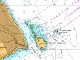
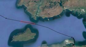
#MarineNotice - Mariners are advised that a Port Lateral Mark has been deployed marking Leac Buidhe Rock, north of Dalkey Island.
The buoy has the following light characteristic Fl(4)R.6s, and will be seasonally deployed from April to October. It can be found at position 53°16.650’N 006°05.100’W.
Afloat.ie understands that the mark placement has been made at the suggestion of Dublin Bay Sailing Club, after a number of incidents in which boats have been damaged by contact with Leac Buidhe Rock.
In 2015, Winter DBSC Turkey Shoot organiser Fintan Cairns issued a warning to competitors to look out for the rock that had caused problems for competitors. See the warning to competitors and a photo of Leac Buidhe here.
While welcoming the new buoy, Cairns also says 'unfortunately it will only be marked for summer months so we will have to be careful during winter'.
Seaweed Harvesting Begins In Bantry Bay

Mechanical harvesting of sub-tidal seaweed was set to begin today (Wednesday 4 July) in Bantry Bay.
Operations by BioAtlantis Aquamarine Ltd, using the Atlantis Explorer (Callsugn EIPQ2) are expected to continue for the duration of the licence until 2024. Harvesting will take place in Areas A, B, C, D and E of the licence area, details of which are included in Marine Notice No 29 of 2018, available to read or download HERE.
The harvesting operations are proceeding despite a High Court challenge to the project by a number of environmental groups, according to The Irish Times.
The High Court has granted a judicial review of the licence awarded in November last year, and opposed by the Bantry Bay - Save Our Kelp Forests group, among others, for its alleged potential to “irreversible damage to the ecosystem and businesses of the Bantry Bay area”.
The Irish Times has more on the story HERE.
Live Firing Practice Off South West Coast This Week

#MarineNotice - The Defence Forces will be conducting surface and air live firing practice shoots in Sea Area South South West (D13) between Seven Heads and Galley Head and to seaward between Tuesday 26 and Thursday 28 June from 8am to 6pm daily.
The danger area comprises the sea area contained within the co-ordinates detailed in Marine Notice No 27 of 2018, a PDF of which is available to read or download HERE.
While the range is active, this sea area is out of bounds to all vessels. A Naval Service patrol vessel will enforce the exclusion zone ‘D13’.
All vessels are required to remain outside of the exclusion zone while the range is active, and are also recommended to carefully monitor the radio navigation warnings that will be broadcast during the firing period.
Marine Notice: Surveys Off South & South West Coasts
#MarineNotice - The survey vessel VOS Sweet (Callsign PCPE) is currently conducting offshore geotechnical and environmental survey operations associated with the proposed Celtic Interconnector on behalf of EirGrid.
The VOS Sweet was set to commence operations yesterday, Monday 18 June, and will operate on a 24-hour daily basis for approximately two weeks in two main corridors off East Cork to three landfall points: Ballinwilling Strand (Ballycotton Bay); Redbarn Beach and Claycastle Beach (Youghal Bay).
The survey is to collect geotechnical data utilising a Vibrocorer (VC) and Cone Penetration Test (CPT) spread and environmental (benthic) data utilising Grab Sampler spread. The survey will be conducted under Foreshore Licence FS006811. Common frequency VHF Channel 16 shall be used throughout the project.
Details of the route centreline co-ordinates as well as intended locations for the VC, CPT and benthic sampling are included in Marine Notice No 26 of 2018, a PDF of which is available to read or download HERE.
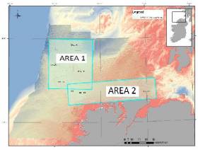
Meanwhile, Providence Resources is carrying out a site survey on its FEL 6/14 licence, called Newgrange, situated between the Southern Porcupine and Goban Spur Basins some 260km off the South West Coast.
The eight-day geophysical survey by the MV Kommandor (Callsign MCJO2), was scheduled to commence on Monday, is using dual-frequency side scan sonar, single-beam and multi‐beam echosounders, side scan sonar, sub‐bottom profilers and magnetometer.
Seabed (benthic) samples will also be taken using a box corer or grab as appropriate, and geotechnical sampling will be undertaken with a piston corer to a minimum target depth of 6m below the seabed.
In addition to the above, and to accurately determine potential future drilling hazards over the Newgrange location, the proposed survey will also include a high resolution 2D seismic which is not expected to exceed two days.
Survey operations will be conducted on a 24-hour basis. The MV Kommandor will be displaying shapes and lights prescribed in the International Rules for the Prevention of Collisions at Sea (COLREGS) Rule 27, to indicate that the survey vessel is restricted in its ability to manoeuvre. A listening watch will be maintained on VHF Channel 16, and the vessel will actively transmit an AIS signal.
Co-ordinates and a map of the expected working area are outlined in Marine Notice No 25 of 2018, a PDF of which is available to read or download HERE.
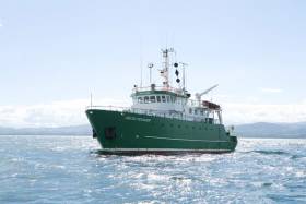
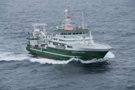
#MarineScience - Researchers at NUI Galway, along with partners at the Irish Centre for Research in Applied Geosciences (iCRAG) and the Marine Institute, are currently carrying out a marine hydroacoustic survey in the eastern margin of the Porcupine Basin.
Continuing till this Saturday 16 June, the project conducted from the RV Celtic Voyager (Callsign EIQN) involves generating an acoustic sound source (seismic airgun) adjacent to a short-term deployment of a hydrophone mooring and drifter array in order to investigate noise propagation across the Irish continental margin. The project is planned to inform research into noise pollution as part of Ireland’s obligations under the Marine Strategy Framework Directive (MSFD).
Approximate locations of fixed moorings and seismic noise transect are included in Marine Notice No 24 of 2018, a PDF of which is available to read or download HERE.
Fixed moorings will include yellow surface buoys with warning lights: high intensity, quick flash, continuous, yellow. The drifter will include a yellow surface buoy with nav light: 5 flashes every 20 seconds, yellow, 2nm distance.
The RV Celtic Voyager is displaying appropriate lights and signals and will be within the vicinity at all times throughout the survey.
Researchers also emphasise that the closest distance from survey to any marine SAC is over 16 nautical miles. Commercial fishing and other marine operators are requested to keep a 3nm distance from any survey instrument moorings, and to keep a 2nm distance around the entire survey area clear of any gear or apparatus during the survey period outlined above.
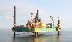
#MarineNotice - The Sandpiper jack-up platform is conducting nearshore geotechnical survey operations associated with the proposed Celtic Interconnector on behalf of EirGrid south of East Cork.
Similar to last autumn’s nearshore survey, the operations are taking place at three coastal locations – namely Ballinwilling Stran, Redbarn Beach and Claycastle Beach.
The Sandpiper (Callsign V3UA) will operate on a 24-hour daily basis commencing at the earliest from the Monday 14 May for approximately two weeks.
The Sandpiper is a non-self-propelled jack-up barge measuring 18.3m x 12.2m consisting of five Quadra pontoons and two duo pontoons with four 27m legs. The Sandpiper will be towed by the Trojan (Callsign EIEX6), a tug measuring 16m x 5m. Common frequency VHF Channel 16 shall be used throughout the project.
The survey will be conducted under Foreshore Licence FS006811, and is to collect geotechnical data utilising drilling spread only.
The nearshore survey activities will extend no more than 5km from the shoreline within a 500m area or corridor centred on the co-ordinates detailed in Marine Notice No 21 of 2018, a PDF of which is available to read or download HERE.
‘Next Generation’ Weather Buoy Set For Testing
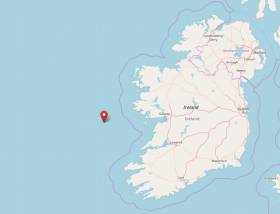
#Weather - The Marine Institute is preparing to carry out deployment and extended testing on a next-generation weather buoy from next week.
The ILV Granuaile (Callsign EIPT) will position the data buoy at 53°07.36'N 11°12.00'W. A Statutory Sanction will be in place.
The buoy is a yellow special mark buoy fitted with a yellow light with characteristics FL Y (5) 20 seconds.
Works are scheduled to begin on Monday 7 May and will continue until May 2019.
Geophysical Research Survey Off North West Coast In May
#MarineNotice - Maynooth University will carry out a geophysical research survey off the North West Coast of Ireland from next weekend.
Work is expected to commence on Sunday 6 May and last for approximately nine days, subject to weather conditions.
The Marine Institute’s research vessel RV Celtic Voyager (Callsign EIQN) is scheduled to carry out the works for the Mara survey, undertaken by researchers in Maynooth University to collect geophysical acoustic survey data as well as sediment grab and core samples.
The survey will use relatively low amplitude sound sources to image into the seabed including an echosounder and a sparker system, which will allow for the characterisation of seabed type to inform the deglacial dynamics of the climatically driven British Irish Ice Sheet.
The vessel will, on occasion, be towing a hydrophone cable and other equipment, up to a maximum of 50 metres behind the vessel. The vessel will be restricted in its movements when towing a cable astern.
All other vessels are requested to give the operation a wide berth. The vessel will be listening on VHF Channel 16 throughout the project.
Details of the survey area, relevant co-ordinates and contact information are included in Marine Notice No 19 of 2018, a PDF of which is available to read or download HERE.
#MarineNotice - Hydrographic and geophysical surveys will be undertaken in the Celtic Sea and Atlantic Ocean under the INFOMAR (Integrated Mapping for the Sustainable Development of Ireland’s Marine Resources) programme until October 2018.
Geological Survey Ireland vessels the RV Keary (Callsign EI-GO-9), RV Geo (Callsign EI-DK-6), RV Tonn (Callsign EI-PT-7), RV Mallet (Callsign EI-SN-9) and RV Lir (Callsign EI-HI-2) are already involved in scheduled surveys since March.
Marine Institute vessels the RV Celtic Explorer (Callsign EIGB) and RV Celtic Voyager (Callsign EIQN) will begin surveys this weekend, starting with the former vessel on a three-week survey from Sunday 22 April.
The Celtic Voyager and the Celtic Explorer will be towing a magnetometer sensor with a single cable of up to 200 metres in length. The vessels will display appropriate lights and markers, and will be listening on VHF Channel 16 throughout the course of the surveys.
Details of co-ordinates for these surveys are included in Marine Notice No 18 of 2018, a PDF of which is available to read or download HERE.
Note that the Atlantic Ocean Area may not be surveyed in 2018, but if for operational reasons the survey does take place, it will be during the dates set out above for the Celtic Voyager surveys listed therein. In that event, the Marine Notice will be updated with specific dates.


