


Displaying items by tag: hydrographic survey
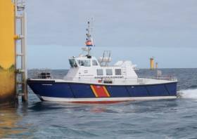
Survey For Proposed Undersea Cable From Ireland To Iceland

Survey works for a proposed new submarine communications cable between Ireland and Iceland will be conducted from next week.
The hydrographic survey is due to take place from next Thursday 10 September and will be completed by early November.
Works during the 24/7 cable route survey will involve the stern deployment of a sonar towfish, tethered with steel cable at varying water depths, to collect geophysical/bathymetric mapping data for the proposed undersea telecommunications cable along a 540km route.
The survey will be conducted from the RV Ridley Thomas (Callsign V7JK2), which will be restricted in its ability to manoeuvre.
All other vessels, including fishing vessels, are requested to maintain distance of at least one nautical mile at all times.
Co-ordinates of the search area as well as relevant contact details are included in Marine Notice No 37 of 2020, which is available to download below.
Upcoming Hydrographic & Geophysical Surveys In The Irish Sea For Arklow Bank Wind Park
Hydrographic and geophysical surveys will be undertaken in the Irish Sea off the Wicklow coast between June and September 2019 to provide bathymetric and subsurface information to facilitate the development of the Arklow Bank Wind Park.
The survey dates are weather dependent but are anticipated to start in June and be completed by the end of September.
The location of the surveys will be off the Wicklow coastline. They will be completed using two vessels working in parallel across the site. The vessels involved are the AMS Panther (Callsign: 2EHC2), which is a 17m windfarm support catamaran, and the AMS Retriever (Callsign: MEHI8) which is a versatile multi-purpose shallow draft tug.
Both vessels will be engaged in survey operations and will be restricted in their ability to manoeuvre. The vessels will be towing survey equipment up to 100 metres astern. Vessels are requested to leave a wide berth. The vessels will be operating 24 hours per day during survey works.
Details of the survey area and relevant co-ordinates are included in Marine Notice No 11 of 2019, a PDF of which is available to read or download HERE.
Marine Notice: Hydrographic & Geophysical Survey Off Mayo Coast, Celtic Sea & Irish Sea
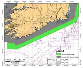
#MarineNotice - The latest Marine Notice from the Department of Transport, Tourism and Sport (DTTAS) has been advised that a hydrographic and geophysical survey operation will be undertaken by INFOMAR for the Sustainable Energy Authority of Ireland (SEAI) off the Mayo coast, in the Celtic Sea and also in the Irish Sea between 21 March and 30 October 2016.
The RV Celtic Voyager (Callsign EIQN), the RV Celtic Explorer (Callsign EIGB), the RV Keary (Callsign EIGO9), the RV Geo (Callsign EIDK6) and the RV Tonn (Callsign: EIPT7) are expected to carry out survey operations and will be listening on VHF Channel 16 throughout the project.
Details of co-ordinates for the survey operations are included in Marine Notice No 11 of 2016, a PDF of which is available to read or download HERE.

#MarineNotice - The latest Marine Notice from the Department of Transport, Tourism and Sport (DTTAS) advises that a hydrographic and geophysical survey operation will be undertaken by INFOMAR1 off the west coast of Ireland from tomorrow 23 July till 17 August.
The RV Celtic Voyager (Call sign EIQN) – which earlier this year was equipped with a new multibeam sonar – is expected to carry out the survey operations in Killary Harbour and its approaches, off the west coast, in Galway Bay and in an area northwest of Tralee Bay.
The work vessel will be towing a magnetometer sensor with a single cable of up to 100m in length. The vessel will display appropriate lights and markers and will be listening on VHF Channel 16 throughout the course of the survey.
Full details of co-ordinates and maps of the survey areas are included in Marine Notice No 45 of 2014, a PDF of which is available to read or download HERE.

#MarineNotice - Following from this weekend's survey in Donegal Bay, INFOMAR will undertake a hydrographic and geophysical survey off the West Coast in the Galway Bay area between 25 May and 7 June 2014.
The RV Celtic Voyager (Call sign EIQN) is expected to carry out the survey operations, which follow up on a previous survey completed in February.
The vessel will be towing a magnetometer sensor with a single cable of up to 100m in length.
She will also be displaying appropriate lights and markers, and will be listening on VHF Channel 16 throughout the project.
Details of the survey area are included in Marine Notice No 32 of 2014, a PDF of which is available to read or download HERE.
Marine Notice: New Hydrographic Survey In Donegal Bay

#MarineNotice - INFOMAR will undertake a hydrographic and geophysical survey in Donegal Bay next weekend 24-25 May.
The RV Celtic Voyager (Call sign EIQN) is expected to carry out the survey operations, which follow up on a previous survey completed last month.
Though the vessel will not be towing any instruments during this survey, she will have limited limited manoeuvrability due to survey line constraints.
The vessel will display appropriate lights and markers, and will be listening on VHF Channel 16 throughout the project.
Details of the survey area are included in Marine Notice No 31 of 2014, a PDF of which is available to read or download HERE.
Marine Notice: Hydrographic Survey Off South Coast

#MarineNotice - The latest Marine Notice from the Department of Transport, Tourism and Sport (DTTAS) advises that a hydrographic and geophysical survey operation will be undertaken by INFOMAR off the south coast of Ireland between 10 July and 7 August 2013.
The RV Celtic Voyager (Call sign EIQN) is expected to carry out the survey operations within an area bounded by co-ordinates detailed in Marine Notice No 26 of 2013, which is available to read or download HERE.
The vessel will be towing a magnetometer sensor with a single cable of up to 100m in length. The RV Celtic Voyager will display appropriate lights and markers and will be listening on VHF Channel 16 throughout the project.
All mariners are reminded of their responsibilities under the International Collision Regulations and are reminded of Marine Notice No 17 of 2007, which gives general advice in relation to the activities of vessels engaged in survey work for hydrographic, seismic, fishing research and underwater operations.

#MarineNotice - The Department of Transport, Tourism and Sport (DTTAS) has issued a Marine Notice advising that a hydrographic and geophysical survey operation is taking place off the south coast till 4 June.
The RV Celtic Voyager (Call sign EIQN) - which performed a similar task off the Clare coast last month - is carrying out the survey operations in an area along the Cork coast marked out in Marine Notice No 18 of 2013, a PDF of which is available to read or download HERE.
The vessel will be towing a magnetometer sensor with a single cable of up to 100m in length. As usual, the vessel will display appropriate lights and markers, and will be listening on VHP Channel 16 throughout the project.

#MarineNotice - Marine Notice No 15 of 2013 from the Department of Transport, Tourism and Sport (DTTAS) advises mariners that a hydrographic and geophysical survey operation is being undertaken by INFOMAR for the Sustainable Energy Authority of Ireland till 25 April.
The RV Celtic Voyager (Call sign EIQN) is carrying out the survey operations within an area bounded by co-ordinates included in the notice, available as a PDF to read or download HERE.
The vessel is towing a magnetometer sensor with a single cable of up to 100m in length. It is also displaying appropriate lights and markers, and will listen in on VHF Channel 16 throughout the project.
Meanwhile, Marine Notice No 16 of 2013 advises that Shell E&P Ireland is deploying a Waverider buoy off northwest Co Mayo to help predict sea conditions for the laying of an offshore umbilical to the Corrib Gas Field later this year.
The buoy is yellow in colour and will flash yellow five times every 20 seconds. The notice includes an image of what the buoy looks like in the water, as well as the co-ordinates of its placement.
All vessels are requested to give the wave buoy a wide berth.
Marine Notice: Clare Coast Hydrographic Survey

#MarineNotice - The latest Marine Notice from the Department of Transport, Tourism and Sport advises of a hydrographic and geophysical survey operation being presently undertaken off the Clare coast till Tuesday 19 March.
The RV Celtic Voyager (Call sign EIQN) is carrying out these survey operations for INFOMAR on behalf of the Sustainable Energy Authority of Ireland (SEAI).
The vessel will be towing a magnetometer sensor with a single cable of up to 100m in length. The Celtic Voyager will be listening on VHF Channel 16 throughout the project and will display appropriate lights and markers.
Details of co-ordinates for the survey area are included in Marine Notice No 10 of 2013, a PDF of which is available to read or download HERE.


