


Displaying items by tag: Storm
The Week's Most Impressive Waves From Ireland To Portugal
#Waves - TheJournal.ie has compiled some of the most breathtaking images of the exceptional waves that crashed on the coastlines of Western Europe from Ireland to Britain to France and Portugal over the past week.
The incredible swells saw surfing pros flock in their hundreds to big wave hotspots like Mullaghmore Head in Co Sligo, where regular visitor Andrew Cotton was filmed riding the monsters churned up by the recent Atlantic storms.
Storm Surges Send Seasiders Fleeing In Lahinch As Flooding Continues

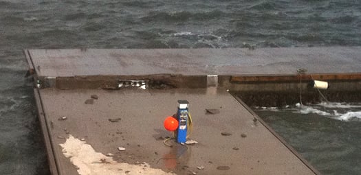
#Flooding - Seaside residents in the popular surfing spot of Lahinch in Co Clare were evacuated yesterday (3 January) after massive swells driven by strong storm-force winds encroached half a kilometre inland.
According to The Irish Times, the emergency came amid some of the worst weather ever experienced in the West Clare coastal town.
Aside from flooding homes throughout the town, the storm surges collapsed metal fencing on the shorefront and sent concrete wall cappings some 50 metres across the promenade car park.
Nearby, part of the old pier in Liscannor were destroyed by the violent wind and wave action, while the 150-year-old base of the Irish Coast Guard's Doolin unit was also damaged, with the road leading from the base to the pier broken up.
Elsewhere in the country, records were broken in Dublin as the River Liffey saw its highest ever tide, breaking its banks near Heuston Station yesterday afternoon.
The Irish Independent reports that Wolfe Tone Quay and Victoria Quay were closed for an hour while Dublin City Council workers pumped the floodwaters from the roads.
In the coastal suburb of Clontarf - the worst-hit area of the capital, experiencing its worst flooding in a decade - seafront businesses were spared when floodwaters stopped just metres from their doors.
Meanwhile, Galway and Cork remain on high alert as high tide brings floodwaters to city streets, with the Salthill Promenade still a no-go area.
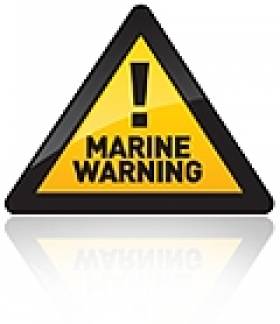
Storm Warning: Water Safety Says 'Stay Away from the Edge'

#marinesafety – Irish Water Safety is warning the public that to stay safe they must stay away from the edges of waterways during storm conditions that are even more dangerous due to heavy rain, strong gale force winds and high tides.
Fast rising flood water is very powerful and often hides the dangers of exposed drains, exposed manhole covers and submerged objects. No driver or pedestrian should take a chance passing through flooded roadways. Parents should caution children that small flooded streams are very fast and that floodwater hides true water depths.
What should I do when I hear a Flood Warning?
1. Listen to the national and local radio for met eireann updates. Click on
http://www.flooding.ie/en/ for further information.
2. Check on neighbours particularly if they are elderly, infirmed or families with young children.
3. Move your vehicles to higher ground.
4. Move animal stock to higher ground.
5. Check your small craft to ensure they are well secured or moored, consider taking them up on a
trailer for safety.
6. Make sure you have warm clothes, food, drink, a torch and radio.
7. Block doorways and airbricks with sandbags or plastic bags filled with earth. Floodgate products
will work effectively also.
8. Switch off gas and electricity supplies if flooding is imminent.
9. Check the time of High Water in the Newspaper or at www.irishtides.ie
Personal Safety
1. Avoid flood waters at all times.
2. Carry a mobile phone at all times in case you need to call for help - call 112 in emergency.
3. Wear suitable protective clothing & a Lifejacket in on or around water.
4. Never try to swim through fast flowing water.
5. Never put your feet down if swept away.
6. Flooding on roads will be deeper at dips and around bridges.
7. Stay away from sea and flood defences.
8. When walking or driving, be aware of manhole covers and gratings that may have been moved
due to the heavy flow of water.
9. Take care when using electric appliances in damp or flood conditions.
10. Remember that during the hours of darkness the dangers are multiplied.
Red Alert – Winds to Reach 150km, High Seas Forecast

#storm – Met Eireann have issued a 'status red' weather warning for Western and Northwestern counties, Galway, Mayo, Sligo, Leitrim and Donegal.
Storms will develop later today, with strong south to southwest winds expected over those counties, with damaging gusts of 120 to 150 km/h this afternoon and evening. This will also lead to very high seas.
Batten Down the Hatches as Storm Approaches Ireland
#storm – Ireland is bracing itself for a fast aproaching southwest gale or strong gale at first this evening on coasts from Loop Head to Fair Head to Roches Point and on the Irish Sea according to Met Eireann. The state forecaster who has issued a status orange alert says northwest or cyclonic gale to storm force winds expected for a time tonight in the South Irish Sea. The forecast follows a Coastguard warning to the public to be careful on exposed westerly coasts, cliffs, piers, harbour walls, beaches, and promenades.
West to Northwest gales are expected to develop later tonight and tomorrow morning on all sea areas; with winds increasing to strong gale force at times tomorrow afternoon on coasts from Wicklow Head to Loop Head to Fair Head and on the South Irish Sea.
Met Éireann Warns Of Storm Force Winds Around Coast

#Weather - Met Éireann has issued a weather warning for tonight (Saturday 22 December) with winds expected to reach up to 110km an hour.
Tonight and tomorrow morning, south-west to west winds are likely to increase in most parts of the country, with mean speeds and gusts that "have the potential to be damaging".
The Irish weather service also reports strong gales on all Irish coastal waters and on the Irish Sea, with winds expected to reach storm force later on coasts from Valentia to Erris Head to Fair Head.

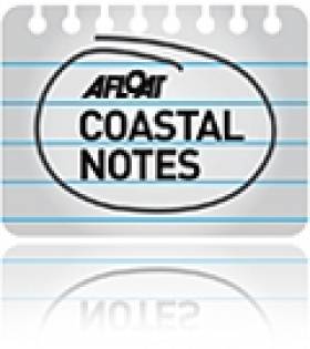
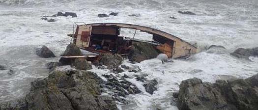
#STORMS – May Day and the first day of Summer 2012 today brings little in the way of joy for boaters on the east coast of Ireland at least who have suffered early season set backs from gales since the beginning of April. Prolonged storm force winds and big seas have wrecked boats, equipment, jetties and piers along the coast.
Many yachts and boats are now safely sheltered in the capital's marinas at Dun Laoghaire, Malahide and Howth but sadly for other skippers it is too late and the 2012 season lies in tatters.
Today's forecast shows another poor week in prospect and while the weather is to improve for next weekend's bank holiday it is not to the extent that it will be a memorable one with cold northerly winds forecast and temperatures of only 9 degrees until next Tueday at least. It seems hard to imagine that in March Ireland was basking in temperatures in the low 20s.
Storm damage is still being assessed in Skerries and Bray where most of the damage has occurred.
Yachts lie wrecked on the rocks in North Dublin. Photos: Dean Jacobs
Less than a week since the boats were craned in at Skerries Sailing Club ISORA champion yacht Raging Bull, skippered by Matt Davis, was on the rocks.
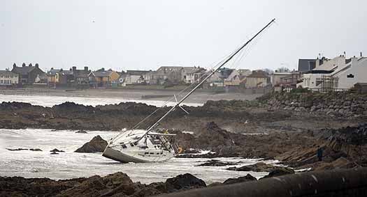
The yacht was among others to be washed ashore in Skerries in north Dublin when moorings apparently broke in the extreme conditions.
In Bray Co. Wickow, no sooner had crews lifted boats in than the crane was back in action lifting Sailing Club yachts out of the harbour again only some were not so lucky.
There is little doubt about the severtiy of the storms that even caused problems in Dun Laoghaire, Co. Dublin where the yacht club pontoon at the Royal St. George Yacht Club was damaged in the first of the storms.
Amazingly through all of this yacht club racing programmes have been followed without a hitch except for the SB3s scrubbed last Sunday. Howth concluded its Spring Warmer series, DBSC has had two great Saturday race days and in between gales the ISORA fleet raced 47 miles from Dun Laoghaire to Wicklow and back.
Damage to yacht club pontoons inside Dun Laoghaire harbour
The new harbour in Greystones was also tested this month and there were many onlookers. The consensus appears that it s been well built but over-topping (where waves can crash over the top of the brekwaters) might make berths in the new marina basin inhospitable when the marina is eventually installed there.
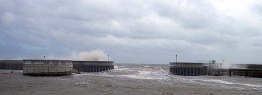
Waves crash over the new harbour walls in Greystones in the first week of April
We are documenting the damage to boats causd by the gales. If you have photos or videos please send them to [email protected]
Ship-to-Ship Transfer of OIl Cargo Delayed Yet Again

#SHIPPING - The transfer of hazardous cargo from the stricken tanker at the entrance to Belfast Lough has been delayed yet again due to winds nearing hurricane strength.
The Belfast Telegraph reports that the Genmar Conpanion - which was redirected to Belfast after reporting a cracked hull en route from Rotterdam to New York - will remain sheltering off the Copeland Islands until the weather improves.
As previously reported on Afloat.ie, the ship-to-ship transfer of 54,000 tonnes of vacuum gas oil was originally scheduled to take place on 31 December last, but the task was pushed back as the receiving ship, BW Seine, was delayed by weather in the North Sea.
It had then been hoped to begin the transfer early yesterday with the receiving ship's arrival, but the strong storm-force winds that have increasingly battered Ireland in the last 36 hours put paid to those plans.
Ship-to-ship transfers can take place in wind speeds of up to 35 knots, but yesterday the wind speed in Belfast Lough was reported as more than double that.
Hugh Shaw, the NI Secretary of State's representative for maritime salvage and intervention, told the Belfast Telegraph: "As soon as we have a window to do the ship-to-ship transfer safely we will take it.
"Winds have been dropping a bit, but it looks unlikely the operation will take place on Wednesday."
Ireland Battered by Storm-Force Winds

#WEATHER - Ireland has been warned to brace for further strong winds set to sweep across the country today (4 January),
The Irish Times reports. Winds reaching near hurricane speeds have affected coastal communities in the north and northwest, peaking at a remarkable 168km/h in Donegal.
Thousands of euro worth of damage was caused when the roofs of traditional thatched cottages at Cruit Island in west Donegal were blown away.
But the west and east have also been hard hit, with storm-force gales exceeding 100km/h uprooting trees and disrupting electricity supply.
As previously reported on Afloat.ie, ferry services on the east coast have been severely affected. Irish Ferries cancelled two fast ferries from Dublin to Holyhead yesterday, and today's early Jonathan Swift sailings between Dublin and Holyhead were also cancelled.
Met Éireann expects wind speeds to be lower today, but could still reach 90-120km/h in some areas.
The Irish Times has much more on the story HERE.
Cornish Surfer Rides Ireland's Record Biggest Wave
#SURFING - British surfer Jayce Robinson wasn't about to let the largest wave ever recorded off Ireland's shores go by without giving it a shot.
And as Sky News Online reports, he was captured doing exactly that on Tuesday afternoon.
The Cornish surfing pro told the website: "It was definitely the biggest barrell I've ever surfed.
"I was a little nervous but I didn't have time to think about it - it's almost like a car crash, you don't know what's happening."
Robinson rode the giant wave for 20 seconds before the lip crashed down and knocked him off his board.
His surfing partner Lyndon Wake, who towed him to the swell at Mullaghmore Head, said: "It's always a worst case scenario when your tow partner wipes out. Lucky he managed to come out the other side OK."
As previously reported on Afloat.ie, storm force winds off the coast of Donegal produced monster rollers of over 20 metres (over 60 feet) in height detected in Donegal Bay.
Mullaghmore Head will once again welcome the world's top big wave surfers for the second annual Tow-In Surf Session in the New Year.


 with (from left) the Marine Institute’s Fiona Grant, Dr Niall McDonough and Joe Silke during her visit to the institute’s Galway headquarters on Friday 5 April")


 Michael Murphy Schull Harbour Sailing Club (SHSC), Eric Coogan Heineken Ireland, Mark Murphy, Commodore SHSC, Jack Allen SHSC, Carmel O'Regan SHSC, Cornelious Ndlovu, Schull Harbour Hotel Operations Manager and Derval Murphy SHSC")


