


Displaying items by tag: flooding
Study Approved For Coastal Flooding Risks On South Galway Bay
Funding for a study to identify risks from coastal flooding in south Galway has been approved by Minister of State for the Office of Public Works (OPW) Patrick O’Donovan.
A sum of €108,000 has been approved for conducting a study identifying houses and businesses at risk from the coastline of Oranmore to Kinvara, Co Galway.
That stretch of the Atlantic coast is very exposed, and, as Afloat reported, some 20 boats and dinghies parked at Galway Bay Sailing Club were seriously damaged or destroyed during Storm Debi last November.
The OPW initiated a minor flood mitigation works and coastal protection scheme in 2009.
Since then, 256 funding applications by Galway County Council have been supported under the scheme.
Coastal Vulnerability to Flooding Focus of New TG4 Documentary
The cost and impact of flooding influenced by climate change and environmental degradation is the focus of a new documentary due to be broadcast on TG4 this month.
“Tuilte”, an hour-long documentary by Dearcán Media, examines just how vulnerable coastal and low-lying regions are to sea level rise, together with increased rainfall and storm events.
It points out that at least 40% of the population lives within 5 km of the coast, and it is estimated 70,000 Irish addresses are at risk of coastal flooding by 2050.
The documentary looks at the impact that flooding has already had on various communities throughout the country, meeting residents in Donegal who suffered serious damage in the storms of August 2017.
It also profiles communities trying to implement sustainable practices to mitigate the effects of flooding and to improve water management.
Among those interviewed are Trish Murphy and the Inishowen Trust, who discuss “innovative nature-based solutions to ‘Slow the Flow’”.
It also interviews Belfast environmentalist Aaron Kelly, who is on a mission to rewild the Black Mountain, providing a tree canopy for wildlife which will also soak up rain during heavy rainfall.
 Galway Labour councillor and businessman Niall McNelis
The documentary focuses on the experience of Galway Labour councillor and businessman Niall McNelis.
His jewellery shop sits just beside the Spanish Arch, and it has been badly flooded six times over 21 years of business, damaging the property and stock each time.
McNelis speaks of the toll it has taken on his mental health in recent years.
It interviews Connemara-based artist Ríonach Ní Néill who reveals her fears for the future, and Micheál Ó Cinnéide a co-founder of Corrib Beo partnership, a voluntary group which promotes the sustainable development of the Corrib catchment.
Tuilte will be broadcast on Wednesday, February 21st at 9.30pm on TG4
Flood Relief For King's Island on Shannon Takes a Step Closer
A flood relief scheme for King’s Island along the Shannon in Limerick came a step closer this week with approval of tenders for a construction project.
The Minister of State with responsibility for the Office of Public Works (OPW) Patrick O’Donovan confirmed on Wednesday (Feb 7) that the OPW has approved issuing of tenders by Limerick city and county council.
Mayor of the city and county of Limerick Gerald Mitchell welcomed the development, which is expected to protect some 528 homes and businesses when completed by the end of 2026.
“It is ten years ago this month since King’s Island was devastated by significant flooding and the images of residents being taken from their homes in boats will live long in the memory,” Mitchell said.
“ Today we are taking a significant step towards delivering vital works to protect homes and businesses in the area,” he said.
“I know that a great deal of work has gone into developing this scheme in an important area of Limerick city with both environmental and archaeological sensitivities,”’O’Donovan said.
“ I also understand that in addition to the much-needed flood relief scheme there will also be important amenities provided for the local community through public realm [funding], and significant conservation works undertaken to those areas of the scheme that interface with the historic fabric of this particularly important area,” he said.
The design began in 2015 with the appointment of Arup and JBA consultants to develop a permanent flood relief scheme for King’s Island.
The preferred option for the scheme, which was subject to public consultation, received planning approval in May 2021.
Mapping Ireland’s seabed, how scientists predict flooding and how to grow your own volcano are themes of an open day hosted by the Geological Survey of Ireland (GSI) and National Museum of Ireland this weekend.
The free “Down to Earth” open day event takes place on Saturday next, May 7th, at the National Museum of Ireland - Decorative Arts and History, Collins Barracks, Dublin.
GSI scientists will be on hand to “bring land and seabed mapping to life, to show the importance of groundwater, and reveal the secrets of Irish fossils,” the organisers state.
They will be joined by colleagues from DIAS (Dublin Institute for Advanced Studies), iCRAG (the Science Foundation Ireland research centre in applied sciences), Met Éireann, and Teagasc to answer questions on earthquakes, the metals we need for life, weather and flooding, and soil.
Members of the public are invited to “try and stump the geologist” by bringing a favourite rock or fossil to have it identified by a geology curator from the National Museum of Ireland.
Sustainable arts experts ReCreate will be running workshops for those families who would like to design some geology inspired art.
The open day takes its inspiration from “Down to Earth- Exploring Ireland’s Geology”, which is currently on exhibition.
Booking is not required, and members of the public can drop in to Collins Barracks, Dublin from 11 am on Saturday, May 7th.
Coastguard & Lifeboat Crews Called to Rescue People Trapped in Their Homes After Christmas Day Flooding in Wexford
Fethard RNLI joined Kilmore Quay’s coastguard unit in a multi-agency operation to rescue local residents trapped in their homes by heavy flooding on Christmas Day, according to RTÉ News.
It’s reported that a number of people in the village of Bridgetown were safely removed by lifeboat, while motorists who were either cut off by the flooding or trapped in the water were also assisted.
Wexford Civil Defence and Wexford Fire Service also joined in the rescue effort on Saturday 25 December, as Kilmore Quay Coast Guard acknowledged on social media.
Heavy rainfall delayed the arrival of the Waterford-based Irish Coast Guard helicopter Rescue 117 — and was also responsible for the erosion of bridges near Enniscorthy due to the swelling of the River Borough (Boro), a tributary of the River Slaney.
In a statement, Transport Minister Eamon Ryan said his department “will provide full support for Wexford County Council and other councils as they address and repair the damage caused by the flash floods”.
Video Shows Cruiser Fleet Carried Away Amid Severe Flooding in France

Dramatic footage has emerged of what’s purported to be a Le Boat cruiser fleet as its carried away in swollen rover waters amid severe flooding in southwestern France.
A video compilation posted on social media shows how at least one vessel was lost as it capsized after hitting a bridge, while another was apparently destroyed at a weir.
Severe flooding was reported throughout the wider region of Lot-et-Garrone after the country was hit by Storm Justine earlier this week and experienced days of torrential rain.
As Euronews reports, the town of Meilhan-sur-Garrone was almost entirely submerged as the Garrone, a major river in the region, burst its banks.
Flood Relief Scheme Begins On River Bandon

#FloodRelief - The scheduled Bandon Flood Relief Scheme work programme for 2017 has now commenced on the River Bandon in Co Cork.
The scheme consists of a combination of flood defences and dredging of the river bed to a level of 9.5m downstream of the Bandon weir (about 1.8m below the existing bed level) in the town and at a grade of 1/1,000 until it reaches the existing bed level 3.6km downstream of Bandon town.
Some 150,000 cubic metres of material will be dredged in the scheme, while new flood defences will also be constructed to contain flood water within the Bandon and Bridewell Rivers as well as the Mill Stream.
Since July 2016, Inland Fisheries Ireland’s (IFI) local representatives have attended meetings with the contractor Wills Bros Ltd, the employer’s representatives (ByrneLooby/PH McCarthy) and environmental consultants to the contractor (Rivus) to review the specific methodologies proposed to undertake the works.
While maintaining a positive approach to the Flood Relief Scheme, IFI says it made proposals in relation to the proposed methods of dredging, sediment management and solids level monitoring, in order to minimise any potential negative impact on the habitat, fish and aquatic invertebrate populations of the river.
While there is some discolouration of the River Bandon expected downstream of the works, IFI says it is reassured by ByrneLooby/PH McCarthy that the Construction Environmental Management Plan (CEMP) and agreed sediment management and solids monitoring plans are being followed.
IFI will continue monitoring dredging works and will bring any non-compliance with the conditions set out to the immediate attention of ByrneLooby/PH McCarthy to ensure corrective measures are put in place.
Any repeated or deliberate non-compliances would be dealt with by IFI using its statutory powers.
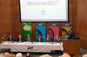
#Shannon - Minister of State for Flood Relief Seán Canney outlined a range of additional measures being taken to address flood risk on the River Shannon at the recent Environ 2017 conference in Athlone.
Speaking at the event in AIT last Monday (10 April), Minister Canney made reference to the most recent meeting of the Shannon Flood Risk State Agency Co-ordination Working Group on 21 March, which set out its actions manage flood risk for the Shannon catchment.
“This extensive work programme demonstrates the ongoing work and co-ordination by all State bodies to jointly and proactively address flood risk on the Shannon,” he said.
The work programme follows from the major decision taken last December to develop a plan for a strategic maintenance programme on the River Shannon, as previously reported on Afloat.ie.
The working group established a sub-committee to develop the plan that will halt the deterioration of the river channel and complement the preferred measures for those areas at assessed risk identified through the Shannon CFRAM Study.
Minister Canney announced that the working group has now agreed to the delivery of targeted maintenance in specific locations that are being identified as feasible by the sub-committee.
“The recent targeted activity by Waterways Ireland and the OPW around Madden’s Island downstream of Athlone is a successful demonstration of this collaborative approach,” he said, “and both the Group and I would like to acknowledge the valuable contribution of the NPWS to ensure that the clearing of the trees was carried out appropriately to enhance the conveyance capacity of the channel.”
The minister added that the working group has agreed to some environmental and habitat surveys as a first necessary step to inform a long-term plan of maintenance. The group will also identify any policy or legislative barriers to progressing maintenance works that can benefit flood risk management.
Additionally, the working group has agreed to review and continue the pilot lowering of the levels on Lough Allen during the winter season for another year.
Minister Canney said the protocols agreed between the ESB, Waterways Ireland and the Office of Public Works (OPW) were successfully implemented resulting in a lowering of the target winter water level by 0.7 metres.
However, working group acknowledged that the impact of the trial on flooding has not been fully tested due to the relatively dry winter period up until late February this year.
Regarding the impact of summer flooding on the agricultural community, the minister said the working group has endorsed a specific project to identify viable flood risk reduction measures in the Shannon Callows.
Building on initial assessments undertaken as part of the Shannon CFRAM study, the OPW is leading on the project in conjunction with Waterways Ireland, Inland Fisheries Ireland and the National Parks and Wildlife Service (NPWS). This project will include more detailed assessment of the possible removal of identified constrictions or ‘pinch points’ upstream of Meelick Weir.
“I am delighted that the group, which is chaired by the OPW, is progressing the plans for strategic maintenance works on the River Shannon,” said Minister Canney. “This will complement the group’s work programme and the specific measures that are identified for the areas at significant risk in the Draft Shannon Flood Risk Management Plan.
“I welcome the twin-track approach being adopted which will see targeted maintenance activity being carried out while a proposal for a long-term strategic programme is being developed.”
The minister added: "The activities of the group play a valuable role in supporting the objectives of the Action Plan for Rural Development, ‘Realising our Rural Potential’. In particular, the progression of flood relief actions in the Shannon catchment identified in the action plan along with those identified for the country as a whole, will have a positive impact on rural communities who are living with flood risk.”
Yacht Club Prepares for Flood Risk With Emergency Kit Donation

One of the UK’s top technology firms is helping one of the UK’s top sailing clubs to prepare for an event, which hopefully will never occur.
Pump Technology, based in Berkshire, whose group of companies include LeeSan Marine Sanitation, contacted Ullswater Yacht Club to offer their unique equipment to assist, should the unthinkable happen, and the Club is hit by another flood.
Pump Technology has been in existence for 25 years and supply pumps for wastewater disposal. Their unique equipment is used in all seven Astute submarines built in Barrow in Furness. They also supply pumping equipment for UK leading businesses, including Marks and Spencer, Tesco, Greggs and many more.
LeeSan have been supplying marine sanitation equipment and sewage pump out stations to the boating market for over 50 years and were extremely instrumental in developing the “Closed tank” system, which now keeps all of our lakes and canals free of black water waste.
Clive Vare, Project Manager for Pump Technology said “Our firm made contact with Ullswater Yacht Club after one of their members telephoned us for advice. We were sad to hear of the severe flooding which Storm Desmond caused to the area and were happy to offer our assistance. Hopefully the area will not be affected by flooding again, but should this happen our Flood Emergency Kit will certainly be of immense value.”
The Flood Emergency Kit has kindly been donated to UYC by Pump Technology and should an emergency flooding situation arise will enable members to react quickly to tackle the problem.
The kit, which can be easily stored, comes in a carrying case, which acts as a filter, and quickly pumps water out of a building via the fire style hose.
Peter Lewis, Commodore of Ullswater Yacht Club said “We are extremely grateful to Pump Technology for kindly donating the Flood Emergency Kit. If the area is again hit by flooding our members can use the kit to fight back, limit damage and recover quickly”. He continued, “The kit can also be used for other purposes, including getting rid of excess water in boats at risk of sinking”.
Strategic Maintenance Plan Decided For Shannon Flood Risk Management

#Shannon - The latest meeting of the Shannon Flood Risk State Agency Co-ordination Working Group in Carrick-on-Shannon saw the unprecedented decision to develop a plan for a strategic maintenance programme on the River Shannon.
Programmed maintenance works have not been carried out on the Shannon for a significant period of time, and silt and vegetation have built up, which impacts on the river’s conveyance capacity.
The Shannon Flood Risk Group, which is led by the Office of Public Works (OPW), considers that maintenance works on the Shannon are essential to halt the deterioration of the river channel.
The group recognises that the carrying out such maintenance will be problematic and in bringing forward its plans, it will be addressing all of the necessary legal, environmental, technical and other considerations that arise, and will bring together all of the relevant stakeholders to discuss, initiate and manage the development of this programme.
Séan Canney, Minister of State for the OPW and Flood Relief, was in attendance at the meeting on Friday 2 December.
“The OPW already maintains over 11,500 km of river channel and over 700km of embankments protecting some 650,000 acres of agricultural land,” he said. “I am delighted that the group, which is chaired by the OPW, has taken the decision to develop a plan for strategic maintenance works on the River Shannon.
“There have been many calls for a maintenance programme to be put in place for the Shannon. A planned maintenance programme for the Shannon would complement the group’s work programme and the specific measures that are identified for the areas at risk in the Draft Shannon Flood Risk Management Plan.
Minister Canney said such plans “are a major step forward to help Government make informed investment decisions on flood risk management and for which the Government has provided €430 million in the Capital Investment Plan 2016 to 2021.
“This is very positive news and comes on top of the decisions by the group at its last meeting to trial the lowering of the lake levels in Lough Allen to help mitigate potential flood risk for this winter ,and to evaluate the benefits from any short- and medium-term programme of localised dredging and any future piloting to remove some pinch points along the Shannon.”
The Shannon Flood Risk Group met for the first time in February of this year, as previously reported on Afloat.ie.
“The decisions taken by the group to date clearly demonstrate that it is working well and is firmly focussed on finding practical solutions that will help reduce flood risk on the Shannon to the benefit of the communities along our largest river,” said Minister Canney.
“The results of this cutting-edge project will inform consideration of rolling out a similar management model for other river basins.”


 Michael Murphy Schull Harbour Sailing Club (SHSC), Eric Coogan Heineken Ireland, Mark Murphy, Commodore SHSC, Jack Allen SHSC, Carmel O'Regan SHSC, Cornelious Ndlovu, Schull Harbour Hotel Operations Manager and Derval Murphy SHSC")

