Menu

Ireland's sailing, boating & maritime magazine

Displaying items by tag: Glider

The Marine Institute’s marine glider has been deployed in the North Atlantic as part of a deep ocean marine science research project.

Laochra na Mara can reach depths of 1,000m and collects oceanographic data on conductivity, temperature, depth, fluorescence, turbidity and dissolved oxygen.

The glider was deployed from the RV Águas Vivas as part of the fifth project meeting for the Innovation in the Framework of the Atlantic Deep Ocean (iFADO) project recently held in The Azores, Portugal.

Prior to deployment, the glider was exhibited to the public at the Horta Maritime Terminal where local school students met iFADO team members and viewed several videos about glider operations and missions.

The school students also wrote messages on the glider before it was launched.

“Equipped with a wide variety of sensors, the glider can gather information about ocean temperature, salinity and currents, and transmits this information to shore via satellite,” Thomas Dabrowski of the Marine Institute said.

“Gliders are able to provide real-time data, and provide a better assessment and understanding of our ocean environment.”

Gliders are programmed to surface at designated times and transmit the data collected while at the same time downloading new mission instructions. This two-way communication allows gliders to continually gather information about the most important and diverse regions of our ocean basins 24 hours a day.

Similar to a glider from the United States that was found off Baltimore in 2017, the Slocum glider was recently recovered in the North Atlantic Ocean after 15 days at sea — during which it covered over 250km and performed over 40 deep dives.

The fifth iFADO project meeting gathered 50 participants and partner leads to hear the latest results and discuss future co-operation and follow-up action.

The iFADO project aims to create marine services at regional and sub-regional scale using the EU’s Atlantic waters as a case study. It combines traditional monitoring with cost-effective state-of-the-art technologies such as remote sensing, numerical modelling and emerging observation platforms such as gliders and oceanic buoys.

The Marine Institute is one of 20 partners from Ireland, the UK, France, Portugal and Spain involved in the iFADO project. The project has received funding from the European Union’s Interreg Atlantic Area Programme.
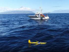
Published in Marine Science

#MarineScience - A deep-ocean drone was recovered with the help of the Marine Institute off the coast of Baltimore in West Cork earlier this month.

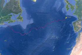
The SILBO autonomous glider, deployed by Teledyne Webb Research USA from Falmouth, Massachusetts in April last year, was sent on a mission to cross the North Atlantic and gather data from the ocean.

SILBO is one of 16 gliders undertaking 128,000km of co-ordinated surveys following an ocean gyre around the five global ocean basins. as part of the Unesco-endorsed Challenger mission.

Gliders look like torpedoes but lack propellors and an engine, instead relying on a movable internal ballast and external moveable fins to move across the ocean. They contain large battery packs to power the movement of the fins and change the internal ballast, as well as to power the glider’s sensors for ocean monitoring.

"Gliders like SILBO are equipped with a variety of sensors that enable scientists to monitor the ocean temperature, salinity, currents and other ocean conditions as well as offering a picture of places in the ocean that traditional satellites and research vessels may not be able to,” explained Aodhan Fitzgerald, RV operations manager at the Marine Institute, which used its remote operated vehicle to help recover the drone off Baltimore on Thursday 9 March.

“By contributing real-time data to a global portal, deep-sea gliders enable marine scientists to mutually benefit by creating a better assessment and understanding of the ocean and evaluating the ocean environment.”

Gliders like SILBO have the ability to go where it is impractical to send people. They can travel major distances over long periods of time, moving both horizontally and vertically through the ocean, continually gathering data.

The drones are also programmed to surface at designated times throughout their mission, allowing them to transmit the data they have collected to shore while at the same time downloading new mission instructions.

This two-way communications ability allows gliders to continually gather information about the most important and diverse regions of our ocean basins.

The Marine Institute says it is currently developing its capacity to use such gliders as they are an important tool for marine scientists to study and map the dynamic features of the ocean.

"With the opportunity to learn more about deep-sea glider capabilities, SILBO will be used for a training session led by Teledyne Webb Research at the Marine Institute's facilities in Galway,” Fitzgerald added.

“This will involve Irish and international glider technicians learning how to overhaul the glider and prepare it for its next mission before it is re-deployed from Irish shores to complete further mission transects for this global initiative.”

Published in Marine Science

Marine Protected Areas (MPAs) - FAQS

Marine protected areas (MPAs) are geographically defined maritime areas where human activities are managed to protect important natural or cultural resources. In addition to conserving marine species and habitats, MPAs can support maritime economic activity and reduce the effects of climate change and ocean acidification.

MPAs can be found across a range of marine habitats, from the open ocean to coastal areas, intertidal zones, bays and estuaries. Marine protected areas are defined areas where human activities are managed to protect important natural or cultural resources.

The world's first MPA is said to have been the Fort Jefferson National Monument in Florida, North America, which covered 18,850 hectares of sea and 35 hectares of coastal land. This location was designated in 1935, but the main drive for MPAs came much later. The current global movement can be traced to the first World Congress on National Parks in 1962, and initiation in 1976 of a process to deliver exclusive rights to sovereign states over waters up to 200 nautical miles out then began to provide new focus

The Rio ‘Earth Summit’ on climate change in 1992 saw a global MPA area target of 10% by the 2010 deadline. When this was not met, an “Aichi target 11” was set requiring 10% coverage by 2020. There has been repeated efforts since then to tighten up MPA requirements.

Marae Moana is a multiple-use marine protected area created on July 13th 2017 by the government of the Cook islands in the south Pacific, north- east of New Zealand. The area extends across over 1.9 million square kilometres. However, In September 2019, Jacqueline Evans, a prominent marine biologist and Goldman environmental award winner who was openly critical of the government's plans for seabed mining, was replaced as director of the park by the Cook Islands prime minister’s office. The move attracted local media criticism, as Evans was responsible for developing the Marae Moana policy and the Marae Moana Act, She had worked on raising funding for the park, expanding policy and regulations and developing a plan that designates permitted areas for industrial activities.

Criteria for identifying and selecting MPAs depends on the overall objective or direction of the programme identified by the coastal state. For example, if the objective is to safeguard ecological habitats, the criteria will emphasise habitat diversity and the unique nature of the particular area.

Permanence of MPAs can vary internationally. Some are established under legislative action or under a different regulatory mechanism to exist permanently into the future. Others are intended to last only a few months or years.

Yes, Ireland has MPA cover in about 2.13 per cent of our waters. Although much of Ireland’s marine environment is regarded as in “generally good condition”, according to an expert group report for Government published in January 2021, it says that biodiversity loss and ecosystem degradation are of “wide concern due to increasing pressures such as overexploitation, habitat loss, pollution, and climate change”.

The Government has set a target of 30 per cent MPA coverage by 2030, and moves are already being made in that direction. However, environmentalists are dubious, pointing out that a previous target of ten per cent by 2020 was not met.

Conservation and sustainable management of the marine environment has been mandated by a number of international agreements and legal obligations, as an expert group report to government has pointed out. There are specific requirements for area-based protection in the EU Marine Strategy Framework Directive (MSFD), the OSPAR Convention, the UN Convention on Biological Diversity and the UN Sustainable Development Goals. 

Yes, the Marine Strategy Framework directive (2008/56/EC) required member states to put measures in place to achieve or maintain good environmental status in their waters by 2020. Under the directive a coherent and representative network of MPAs had to be created by 2016.

Ireland was about halfway up the EU table in designating protected areas under existing habitats and bird directives in a comparison published by the European Commission in 2009. However, the Fair Seas campaign, an environmental coalition formed in 2022, points out that Ireland is “lagging behind “ even our closest neighbours, such as Scotland which has 37 per cent. The Fair Seas campaign wants at least 10 per cent of Irish waters to be designated as “fully protected” by 2025, and “at least” 30 per cent by 2030.

Nearly a quarter of Britain’s territorial waters are covered by MPAs, set up to protect vital ecosystems and species. However, a conservation NGO, Oceana, said that analysis of fishing vessel tracking data published in The Guardian in October 2020 found that more than 97% of British MPAs created to safeguard ocean habitats, are being dredged and bottom trawled. 

There’s the rub. Currently, there is no definition of an MPA in Irish law, and environment protections under the Wildlife Acts only apply to the foreshore.

Current protection in marine areas beyond 12 nautical miles is limited to measures taken under the EU Birds and Habitats Directives or the OSPAR Convention. This means that habitats and species that are not listed in the EU Directives, but which may be locally, nationally or internationally important, cannot currently be afforded the necessary protection

Yes. In late March 2022, Minister for Housing Darragh O’Brien said that the Government had begun developing “stand-alone legislation” to enable identification, designation and management of MPAs to meet Ireland’s national and international commitments.

Yes. Environmental groups are not happy, as they have pointed out that legislation on marine planning took precedence over legislation on MPAs, due to the push to develop offshore renewable energy.

No, but some activities may be banned or restricted. Extraction is the main activity affected as in oil and gas activities; mining; dumping; and bottom trawling

The Government’s expert group report noted that MPA designations are likely to have the greatest influence on the “capture fisheries, marine tourism and aquaculture sectors”. It said research suggests that the net impacts on fisheries could ultimately be either positive or negative and will depend on the type of fishery involved and a wide array of other factors.

The same report noted that marine tourism and recreation sector can substantially benefit from MPA designation. However, it said that the “magnitude of the benefits” will depend to a large extent on the location of the MPA sites within the network and the management measures put in place.

© Afloat 2022