


Displaying items by tag: Lough Leane
Blue-Green Algae Threat Returns To Killarney Lake
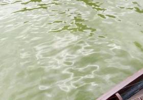
Kerry County Council is once again warning pet owners to be vigilant around Lough Leane in Killarney after the detection of blue-green algae, as RTÉ News reports.
Samples taken in recent days show the presence of the algae, which has the potential to form a scum that’s toxic to animals.
Last July pet owners were advised to be vigilant over the presence of Cyanobacteria which has turned the waterway a soupy pea-green colour.
A previous outbreak in 2016 was connected with a number of dog deaths.
RTÉ News has more on the story HERE.
Toxic ‘Algae’ Threatens Wildlife In Killarney Lake

#Toxic - Pet owners have been advised to be vigilant over an outbreak of toxic blue-green ‘algae’ in a Killarney lake, as The Irish Times reports.
Lough Leane has been signposted by Kerry County Council over the presence of Cyanobacteria that has turned the waters a soupy pea-green colour.
A number of dogs died after exposure to the bacteria during a previous bloom on the lake shore in 2016.
Suspected similar cases have also been reported at Lough Mask as well as waterways further east, including Ballymore Eustace on the River Liffey.
Meanwhile, scientists at the Galway-Mayo Institute of Technology are preparing to use drones to test the water quality of lakes on the West Coast.
GMIT’s Marine and Freshwater Research Centre has secured €132,000 in funding from the EPA for the scheme that will allow for real-time feedback of camera images and data.
Licensed drone pilots will work with lake biologists and water scientists on the two-year project, part of Ireland’s mandate under the EU’s Water Framework Directive.
The Irish Times has more on this story HERE.
Poor Practices Contributed To Lough Leane Ferry Incident Says MCIB Report
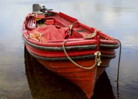
#MCIB - Marine investigators have highlighted a series of poor practices in their report into the flooding of a small passenger ferry on Lough Leane last September.
Twelve passengers and the boat’s master were tipped into the water when the PV Mary Ann of Dunloe, a traditional Irish open clinker, listed to port after being swamped amid heavy waves at Foilcoille Point, en route from Ross Castle to the Gap of Dunloe, on the morning of 1 September 2016.
All involved were rescued by three other vessels and safely retuned to Ross Castle in Killarney.
In its investigations, the Marine Casualty Investigation Board (MCIB) found that the master, who was operating without the requisite Passenger Vessel Commercial Endorsement, had set out in calm conditions but continued to motor the heavily laden boat in weather contrary to its P2 licence.
Rather than being flooded by a single ‘rogue wave’ as the master suggests, the available evidence points to “green seas” on the lake flooding the bilge beyond the capabilities of its pump, says the MCIB report.
“The combination of the prevailing lake conditions, the large amount of water already in the vessel, the speed of the vessel and the turning manoeuvre all contributed to the vessel becoming swamped.”
The passengers’ predicament continued during their rescue, it emerged, with the first vessel to reach them unable to deploy its lifebuoys as they were fastened too tightly.
The second vessel to assist also had difficulties, getting its propeller caught in a rope from and colliding with the casualty boat, holing its own hull. A third vessel, alerted by a passing waterbus, picked up all passengers.
But the MCIB also noted the absence of accurate weather information for Lough Leane, which is subject to very localised conditions but has not had an operational weather buoy for some time.
The full report from the MCIB is available to download below.
Origins Of Fish Unique To Kerry Unveiled By Marine Scientists
#NewFish - A team of marine scientists from UCD, the University of Salford and Inland Fisheries Ireland (IFI) has reconstructed the origins of the endangered Killarney shad.
The fish is known locally as the ‘goureen’ - but many of the anglers who fish for salmon and trout on Lough Leane in Co Kerry are unaware of its presence in their waters.
The Killarney shad is a member of the herring family and lives in shoals, which often show up on the sonar screens of the water buses plying tourists around the lake.
But unlike its close relative the twaite shad, which is known to anglers who fish the tidal waters of the River Barrow at St Mullins in May each year, the Killarney shad believed to be unique to the waters of Lough Leane.
And the new research for the first time provides genetic evidence for the timing of colonisation of the lake by the species after the last glaciations ended.
While the researchers have shown the Killarney shad to be present In Lough Leane for thousands of years, the fish was only formally reported in 1911 by fisheries scientist Tate Regan.
According to IFI, the link between the rivers and sea can become blocked by natural processes or human intervention, such as the building of locks or weirs along a water course. Consequently, once ocean-borne fish may become trapped or ‘landlocked’ in freshwater lakes.
There are several examples of landlocked fish populations which have since adapted to living permanently in freshwater environments, but the evolutionary processes that lead to their origin have rarely been reconstructed.
The existing population of Killarney shad is now genetically isolated from its recent ancestor, the twaite shad. By examining DNA from fish caught in Lough Leane and shad from other areas, researchers were able to show that after the end of the last ice age, some twaite shad were trapped in the lake on two separate occasions.
One coincided with the retreat of the glacial ice sheet from the south west of Ireland some 16,000 years ago; and the other occurred around 7,000 years ago. The descendants of those colonisers interbred, giving rise to the Killarney shad.
Currently there are no natural or manmade barriers in the River Laune connecting Lough Leane to the sea – but the Killarney shad has become so adapted to its new habitat that no migration to the sea is needed for the completion of its life cycle.
While there are landlocked shad populations in the Italian Lake District and in Greece, the Killarney shad is the only example of landlocked shad to have survived in north western Europe. The fish is listed as ‘vulnerable’ on the recent Irish Red Data Book.
Surveys conducted by IFI since the early 1990s have confirmed the presence of the fish in Lough Leane in significant numbers, as well as successful spawning on an annual basis. But the major concern is that a catastrophic environmental event in Lough Leane could eliminate the entire genetic pool, given that the fish is only present in one location.
The Killarney shad is listed in the EU Habitats Directive and Killarney National Park has been designated as a Special Area of Conservation (SAC) for the shad.
"This fish is a unique element of Ireland’s aquatic biodiversity," said Minister of State Fergus O'Dowd. "The present research shines more light on this uniqueness, confirming that ‘evolution’ or change within a species is not something fixed and in the long-distant past."
The minister congratulated the research team on "these very remarkable findings", and noted that IFI head of R&D, Dr Cathal Gallagher, pointed to the importance of State agencies working with third-level institutions to combine applied and academic expertise.
The present research was funded by the Irish Research Council, with support from IFI, and was part of Dr Ilaria Coscia’s PhD, now at Leuven University, Belgium, supervised by Prof Stefano Mariani, now at the University of Salford.
Four More Drownings Bring Renewed Water Safety Appeal
#WaterSafety - Four more people have drowned in separate incidents around Ireland as the heatwave continues.
As RTÉ News reports, a 24-year-old man died while swimming in the sea near Ardara in Co Donegal yesterday afternoon (20 July).
Later, the body of a second victim was recovered from the Shrule River in Newtownstewart, Co Tyrone after getting into difficulty.
A third man in his 60s is was drowned after failing to return from a swim in a quarry near Carrick-on-Suir. His body was recovered earlier today.
The tragedies follow news of a 19-year-old who drowned while swimming with friends in Lough Leane in Killarney on Friday evening (19 July).
And a woman in her 30s was lucky to be rescued after getting into difficulty swimming in the River Nore near Kilkenny. She is currently in a serious but stable condition in hospital.
Irish Water Safety have renewed their appeal for the public to take extra care when taking to the water during this extraordinary hot weather that had already claimed seven lives as of Thursday last.


 Michael Murphy Schull Harbour Sailing Club (SHSC), Eric Coogan Heineken Ireland, Mark Murphy, Commodore SHSC, Jack Allen SHSC, Carmel O'Regan SHSC, Cornelious Ndlovu, Schull Harbour Hotel Operations Manager and Derval Murphy SHSC")


