Menu

Ireland's sailing, boating & maritime magazine

Displaying items by tag: Oriel Wind Farm

The ESB says it “remains committed” to the Oriel Wind Farm project after it was unsuccessful in yesterday’s offshore wind energy auction, as RTÉ News reports.

The proposed wind power array in Dundalk Bay — a partnership between the ESB and Belgian green energy supplier Parkwind — missed out on one of the four contracts awarded to offshore wind projects around the country in the State’s first such auction.

In a statement on Friday (12 May), the ESB said that “while the Oriel project was not awarded a contract in this auction round, Parkwind and ESB believe that it is a well-positioned project and will ultimately play its part in generating the renewable electricity we need. We will continue to progress the project and are actively investigating alternative routes to market.”

Environment Minister Eamon Ryan confirmed on this morning’s edition of RTÉ Radio 1’s Today programme that there will be “a second auction later this year and we will go on the same next year”.

Meanwhile, environmentalists have urged that Ireland must be “wise”, despite the huge potential of green offshore energy, and maintain an “open transparency approach” when it comes to monitoring the status of marine wildlife around such sites.

RTÉ News has more on the story HERE.

Published in Power From the Sea

An ultra-high-resolution geophysical survey will be carried out in the Oriel Wind Farm array area in the Irish Sea off Co Louth to provide bathymetric and subsurface information to facilitate the development of the offshore wind farm.

The survey work was anticipated to start Friday 18 November 2022 and to be completed by mid-December 2022, subject to weather and operational constraints.

Works will be confined to the Oriel Wind Farm array area, which is located between Dunany Point and the Cooley Peninsula.

The survey will be conducted by the Fastnet Pelican (callsign 2FNX7), which is a shallow draft survey vessel. The vessel will be restricted in its ability to manoeuvre due to the deployment of towed survey equipment up to 100 metres astern.

All other vessels operating within this area are requested to leave a wide berth.

The work vessel will display appropriate lights and signals and operations will be conducted during daylight hours. Mariners are advised to keep continuous watch on VHF Channel 16 when navigating the area.

Coordinates and a map of the survey area as well as contact details can be found in Marine Notice No 78 of 2022, attached below.

Published in Powerboat Racing

Trial operations of remotely piloted uncrewed surface vessels (USVs) are planned to take place in the Dundalk Bay area from this week until mid November.

Subject to weather and operational constraints, the operations will run for a period of four weeks from Thursday 20 October.

The XO-450-type USVs from Greenore-based Xocean will be engaged in survey activities for the proposed Oriel Wind Farm in the Irish Sea some 22km off the coast of Dundalk in Co Louth.

This is a non-invasive survey, Xocean says, and no contact with the seabed or any other infrastructure is planned during survey operations.

The USVs will send real-time images and situational awareness data over satellite to a team of operators keeping watch and controlling the vessel remotely 24/7.

Although the vessels are uncrewed, they are constantly monitored and controlled, and piloted remotely using 360-degree cameras and other navigational aids.

Each USV is equipped with AIS, navigation lights and a sound signal, an active radar reflector and a yellow-painted superstructure to make it conspicuous to other marine traffic.

All other vessels operating within the affected area are requested to avoid contact with any USV and be aware of the operational area during this period. A Radio Navigation Warning will be in place during operations.

Contact details, relevant coordinates and a map of the survey area are included in Marine Notice No 71 of 2022, attached below.

Published in Power From the Sea

Geophysical surveys are being undertaken in the Irish Sea in outer Dundalk Bay from this week.

The work is required to provide bathymetric and subsurface information for the development of the Oriel Wind Farm project.

Survey work was expected to start yesterday, Tuesday 20 August, with a view to completion by Monday 30 September, though these dates are weather dependent.

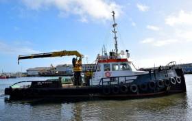
The surveys will be completed using the AMS Retriever (Callsign MEHI8), a versatile multi-purpose, shallow draft tug.

This vessel is towing survey equipment up to 100 metres astern and will be restricted in its ability to manoeuvre.

Other vessels are requested to leave a wide berth. The AMS Retriever will be operating from approximately 6am to 9pm during survey works.

Details of co-ordinates of the survey area are included in Marine Notice No 29 of 2019, a PDF of which is available to read or download HERE.

Published in Coastal Notes

Marine Protected Areas (MPAs) - FAQS

Marine protected areas (MPAs) are geographically defined maritime areas where human activities are managed to protect important natural or cultural resources. In addition to conserving marine species and habitats, MPAs can support maritime economic activity and reduce the effects of climate change and ocean acidification.

MPAs can be found across a range of marine habitats, from the open ocean to coastal areas, intertidal zones, bays and estuaries. Marine protected areas are defined areas where human activities are managed to protect important natural or cultural resources.

The world's first MPA is said to have been the Fort Jefferson National Monument in Florida, North America, which covered 18,850 hectares of sea and 35 hectares of coastal land. This location was designated in 1935, but the main drive for MPAs came much later. The current global movement can be traced to the first World Congress on National Parks in 1962, and initiation in 1976 of a process to deliver exclusive rights to sovereign states over waters up to 200 nautical miles out then began to provide new focus

The Rio ‘Earth Summit’ on climate change in 1992 saw a global MPA area target of 10% by the 2010 deadline. When this was not met, an “Aichi target 11” was set requiring 10% coverage by 2020. There has been repeated efforts since then to tighten up MPA requirements.

Marae Moana is a multiple-use marine protected area created on July 13th 2017 by the government of the Cook islands in the south Pacific, north- east of New Zealand. The area extends across over 1.9 million square kilometres. However, In September 2019, Jacqueline Evans, a prominent marine biologist and Goldman environmental award winner who was openly critical of the government's plans for seabed mining, was replaced as director of the park by the Cook Islands prime minister’s office. The move attracted local media criticism, as Evans was responsible for developing the Marae Moana policy and the Marae Moana Act, She had worked on raising funding for the park, expanding policy and regulations and developing a plan that designates permitted areas for industrial activities.

Criteria for identifying and selecting MPAs depends on the overall objective or direction of the programme identified by the coastal state. For example, if the objective is to safeguard ecological habitats, the criteria will emphasise habitat diversity and the unique nature of the particular area.

Permanence of MPAs can vary internationally. Some are established under legislative action or under a different regulatory mechanism to exist permanently into the future. Others are intended to last only a few months or years.

Yes, Ireland has MPA cover in about 2.13 per cent of our waters. Although much of Ireland’s marine environment is regarded as in “generally good condition”, according to an expert group report for Government published in January 2021, it says that biodiversity loss and ecosystem degradation are of “wide concern due to increasing pressures such as overexploitation, habitat loss, pollution, and climate change”.

The Government has set a target of 30 per cent MPA coverage by 2030, and moves are already being made in that direction. However, environmentalists are dubious, pointing out that a previous target of ten per cent by 2020 was not met.

Conservation and sustainable management of the marine environment has been mandated by a number of international agreements and legal obligations, as an expert group report to government has pointed out. There are specific requirements for area-based protection in the EU Marine Strategy Framework Directive (MSFD), the OSPAR Convention, the UN Convention on Biological Diversity and the UN Sustainable Development Goals. 

Yes, the Marine Strategy Framework directive (2008/56/EC) required member states to put measures in place to achieve or maintain good environmental status in their waters by 2020. Under the directive a coherent and representative network of MPAs had to be created by 2016.

Ireland was about halfway up the EU table in designating protected areas under existing habitats and bird directives in a comparison published by the European Commission in 2009. However, the Fair Seas campaign, an environmental coalition formed in 2022, points out that Ireland is “lagging behind “ even our closest neighbours, such as Scotland which has 37 per cent. The Fair Seas campaign wants at least 10 per cent of Irish waters to be designated as “fully protected” by 2025, and “at least” 30 per cent by 2030.

Nearly a quarter of Britain’s territorial waters are covered by MPAs, set up to protect vital ecosystems and species. However, a conservation NGO, Oceana, said that analysis of fishing vessel tracking data published in The Guardian in October 2020 found that more than 97% of British MPAs created to safeguard ocean habitats, are being dredged and bottom trawled. 

There’s the rub. Currently, there is no definition of an MPA in Irish law, and environment protections under the Wildlife Acts only apply to the foreshore.

Current protection in marine areas beyond 12 nautical miles is limited to measures taken under the EU Birds and Habitats Directives or the OSPAR Convention. This means that habitats and species that are not listed in the EU Directives, but which may be locally, nationally or internationally important, cannot currently be afforded the necessary protection

Yes. In late March 2022, Minister for Housing Darragh O’Brien said that the Government had begun developing “stand-alone legislation” to enable identification, designation and management of MPAs to meet Ireland’s national and international commitments.

Yes. Environmental groups are not happy, as they have pointed out that legislation on marine planning took precedence over legislation on MPAs, due to the push to develop offshore renewable energy.

No, but some activities may be banned or restricted. Extraction is the main activity affected as in oil and gas activities; mining; dumping; and bottom trawling

The Government’s expert group report noted that MPA designations are likely to have the greatest influence on the “capture fisheries, marine tourism and aquaculture sectors”. It said research suggests that the net impacts on fisheries could ultimately be either positive or negative and will depend on the type of fishery involved and a wide array of other factors.

The same report noted that marine tourism and recreation sector can substantially benefit from MPA designation. However, it said that the “magnitude of the benefits” will depend to a large extent on the location of the MPA sites within the network and the management measures put in place.

© Afloat 2022