


Displaying items by tag: Smart Buoys
Waverider Buoy Research Project to Measure How Extreme Storms & Wave Heights will Impact the Coast
A research project led by coastal and ocean scientists in NUI Galway and the Marine Institute involves the deployment of a combination of smart buoys and time-lapse imaging to measure storm impacts and support the development of coastal flood and erosion defences.
The project, Brandon Bay on the Dingle Peninsula, Co Kerry, involves:
- A new waverider buoy provided by Sustainable Energy Authority of Ireland to measure wave height, wave direction, wave period, surface currents, and water temperature as well as storm impact
- Data being made available to view or download on the Marine Institute supported website Digital Ocean, a web portal to view data collected in and around Ireland's maritime zone.
- The installation of a shoreline monitoring system along Brandon Bay at three sites, which will capture images of the beach every 10 minutes during daylight hours over the next 12 months, to identify the time periods when wave run-up is high enough to reach the dune toe and potentially cause coastal erosion. This research is funded by Geological Survey Ireland.
Dr Eugene Farrell, Discipline of Geography and Ryan Institute's Centre for Ocean Research and Exploration (COREx), NUI Galway, said: "We want to improve existing coastal change models by developing better insights into why does change occur and how much change will occur if we dial up climate projections for rising sea levels and storminess. To answer these questions we require process-response coastal models and these are only possible if nearshore observations from wave buoys such as the one in Brandon Bay are deployed over long time periods to capture all the seasons.
"We already know that changes along the coast from elevated storm surge and wave run-up result in changes in seabed and beach elevations. The data captured by the waverider will play an integral part in dismantling the important connections between different storm types such as size, direction, duration, clustering and coastal response that allows us to share real time ocean observations that can be used to address coastal erosion and coastal flood protection.
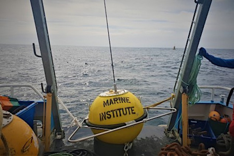
 The wave buoy pictured after deployment in Brandon Bay on the 1, December 2020. Photo: Eugene Farrell, NUI Galway
Alan Berry, Manager of Marine Research Infrastructures at the Marine Institute said, "The wave buoy at Brandon Bay will enable researchers to observe and understand how our ocean is changing and determine how to respond to current and future patterns of change. Open access to this data on Ireland's Digital Ocean website is valuable to climate researchers in Ireland and across Europe."
The Brandon Bay long-term waverider project is co-led by Dr Eugene Farrell, Discipline of Geography, Sheena Parsons, Earth and Ocean Sciences, and Dr Stephen Nash and Andi Egon, Civil Engineering in NUI Galway, and Alan Berry and Conall O'Malley from the Marine Institute with support from the Sustainable Energy Authority of Ireland.
In September 2020, a Coastal Change Technical Working Group was established within the Irish government and tasked with overseeing the development of a scoping report on a national coastal change management strategy. They have envisaged that the scoping report will address issues related to 'baseline and other data capture and research requirements to inform developing, implementing and monitoring a national coastal management strategy, to include potential damages assessment'.
Dr Eugene Farrell adds: "We feel it is our responsibility as coastal scientists to provide the requisite baseline information and recommendations to guide future research along the coast in order to fill knowledge gaps. This is an integral part of the Brandon Bay Waverider project and can be used as a demonstration project so that future investment in coastal infrastructure can be identified.
"Cumulatively, our approach requires a large team of experts to work together. The Maharees in Brandon Bay is already becoming a hub for coastal science thanks to the active community group in the area, the Maharees Conservation Association. There is an urgent need to increase our understanding of coastal change so that that we can better protect our coastal communities and design conservation plans for coastal ecosystems whose dynamic boundaries move in response to changing climate conditions."
The Brandon Bay Waverider project is supported by the Marine Institute, NUI Galway and MaREI, the SFI Research Centre for Energy, Climate and Marine research and the Sustainable Energy Authority of Ireland.
Wave data results from the Brandon Bay Waverider project can be viewed here
Photo: The wave buoy pictured after deployment in Brandon Bay on the 1, December 2020. Photo: Eugene Farrell, NUI Galway
About the Waverider Buoy
The data from the buoy is being used to validate a state-of-the-art high-resolution coastal erosion modelling system comprising of wave, tide and sediment transport models that is under co-development in Civil Engineering, Earth and Ocean Sciences and Geography disciplines at NUI Galway and the Marine Institute since early 2019. The key attraction of these specialised numerical ocean models is their predictive capability. The model predictions are first tested against real-time observations in the bay and then tested for different climate change scenarios such as rising water levels or increasing wave heights.
For example, once the model is validated using the wave buoy observations the project team can test outcomes using the OPW sea level rise scenarios: (1) conservative Mid-Range Future Scenario which uses a sea-level rise of 0.5m by the year 2100 and (2) a High-End Future Scenario, which uses the maximum projected sea-level rise of 1.05m for the year 2100.
Superimposed on these changing sea levels the group can investigate how extreme storms and wave heights will impact the coast and determine how these impacts will be manifested on the coast, such as rates of shoreline retreat or increasing vulnerability of coastal communities and infrastructure.
The yellow spherical wave rider is one metre in diameter, is equipped with an antenna and light and is anchored to the seabed by a mooring. The light will flash yellow for five seconds every 20 seconds in hours of darkness. An accelerometer mounted within the buoy registers the rate at which the buoy is rising or falling with the waves. This type of 'heave, pitch, and roll buoy' is the most commonly used buoy for measuring waves in deep water. It measures the surface height and slope in different orthogonal directions to yield the horizontal and vertical displacements of the buoy.
The Brandon Bay Waverider Acknowledgements
Marine Institute & Sustainable Energy Authority of Ireland
The Marine Institute, supported by the Sustainable Energy Authority of Ireland, have been instrumental in the execution of this project. They have been very generous with their time (research-in-kind) and sharing their expertise and equipment. We would especially like to acknowledge the leadership of Alan Berry, Section Manager, Marine Research Infrastructures and Conall O'Malley, both from the Marine Institute.
The Marine Institute is a State agency responsible for marine research, technology development and innovation in Ireland whose remit is: "to undertake, to coordinate, to promote and to assist in marine research and development and to provide such services related to research and development, that in the opinion of the Institute, will promote economic development and create employment and protect the marine environment." This project exemplifies how scientific progress can be made when academics link up with management agencies like the Marine Institute.
The Sustainable Energy Authority of Ireland is Ireland's national energy agency aiming to create a cleaner energy future by making Ireland's energy sustainable, secure, affordable and clean. SEAI supports the Irish offshore renewable energy sector by advising the government on policy, offering grant support schemes, developing test site infrastructure, and providing information through the Ocean Energy Ireland portal. The Brandon Bay wave rider provided by SEAI will be part of the wave monitoring network of coastal buoys operated on behalf of SEAI by the Marine Institute.
The Marine Institute work with P&O Maritime Logistics who co-led the technical parts of the deployment including the installation of the base station and also the actual deployment.
NUI Galway
The NUI Galway Research Office provided funding support. This office is part of the Office for the Vice President for Research and works closely with the Innovation Office, the Researcher Development Centre and other professional services supporting the NUI Galway research community. We would especially like to acknowledge the support of Aengus Parsons, Director of the Research Office and Professor Lokesh Joshi, Vice President for Research for their support.
MaREI
MaREI is the SFI Research Centre for Energy, Climate and Marine research and innovation co-ordinated by the Environmental Research Institute (ERI) at University College Cork and also based in NUI Galway. We would especially like to acknowledge the support of Dr Stephen Nash in Civil Engineering in NUI Galway. The data from the wave buoy are an integral part of an ongoing MaREI funded PhD programme in NUI Galway.
Maharees Conservation Association and partners
The ongoing coastal and ocean research is not possible without the support of the Maharees community. We are very excited to contribute to our scientific understanding of coastal and ocean dynamics in the bay area with the hope that the results will support ongoing efforts by the community to build their resilience to pressures from storms and people. We would especially like to acknowledge Mr Paddy Buckley and his family for allowing us to install the base station in their home in the Maharees. The NUI Galway team would also like to thank Kerry County Council, National Parks and Wildlife Service and OPW for supporting coastal research in the area.
Irish Lights Smart Buoys Recording High Winds As Storm Rachel Sweeps In

#StormRachel - The Commissioners of Irish Lights' five Twitter 'smart buoys' have recorded high winds in all coastal areas as Storm Rachel hammers Ireland from the Atlantic.
As previously reported on Afloat.ie, Met Éireann had issued a Status Red weather warning for exposed coastal areas in western counties with gusts of up to 150km/h predicted.
And the since-named Storm Rachel proved as strong as expected, with an incredible gust of 138km/h recorded by the Coningbeg buoy of the Wexford coast last night.
Elsewhere, a high of 120km/h was felt in the Aran Islands according to the Finnis buoy, which recorded consistently high winds throughout the night.
And the Ballybunion North buoy recorded 114km/h on a number of occasions overnight, with no let-up in the gusty conditions expected till this afternoon.
The CIL website has more on the MetOcean smart buoy network HERE.
A visualisation of the wind currently over Ireland (from http://t.co/M7F7jfIZ1T) pic.twitter.com/cau3olyvm1
— RTÉ News (@rtenews) January 15, 2015


 with (from left) the Marine Institute’s Fiona Grant, Dr Niall McDonough and Joe Silke during her visit to the institute’s Galway headquarters on Friday 5 April")


 Michael Murphy Schull Harbour Sailing Club (SHSC), Eric Coogan Heineken Ireland, Mark Murphy, Commodore SHSC, Jack Allen SHSC, Carmel O'Regan SHSC, Cornelious Ndlovu, Schull Harbour Hotel Operations Manager and Derval Murphy SHSC")


