


Displaying items by tag: Tommy Furey
Irish 'Underwater Atlas' Launched at Geoscience Event
Following the publication of 'The Real Map of Ireland', showing a three-dimensional overview of Ireland's seabed territory, earlier this year comes 'The Real Atlas' – a detailed compilation of stunning three-dimensional imagery featuring the submarine canyons, underwater mountains and abyssal plains that make up Ireland's seabed territory, an area ten times that of our land mass.
This publication, Atlas of the Deep Water Seabed, Ireland was unveiled today (Wednesday 3rdth November) by Minister of State at the Department of Communications, Energy and Natural Resources, Mr. Conor Lenihan, T.D. at the Geoscience 2010 conference in Dublin Castle. It has been compiled by University College, Cork from data gathered as part of the Irish National Seabed Survey (INSS) and INFOMAR inshore seabed survey undertaken by the Geological Survey of Ireland (GSI) the Marine Institute and partners,
Speaking at the opening of the event Minister Lenihan said, "This is the first such Atlas of its kind world-wide, reflecting our leading role in this field. It will be a valuable resource as we seek to utilise our vast ocean resources in the years ahead. As we develop ocean energy, offshore wind and further oil and gas prospecting, an accurate map of the deep seabed will be vital."
The first day of the conference focused on what has been described by European Commissioner for Research, Innovation and Science, Maire Geoghegan-Quinn as one of the "grand challenges for the 21st Century" – the seas and oceans. It featured detailed papers on seabed mapping, deepwater coral reefs, deepwater remotely operated vehicles and a virtual computer simulation of Galway Bay.
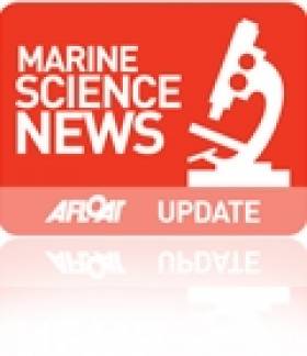
3D image of the 300 km-long Gollum Channel system off the Porcupine Seabight, extending from the edge of the Seabight right down to the Porcupine Abyssal Plain.Image by B. Dorschel with kind permission from Springer Science+Business Media B.V.
First day speakers from the Marine Institute included Fabio Sacchetti, who described the mapping of the Rockall Trough, and Tommy Furey who discussed the value of seabed mapping projects to a wide variety of marine industries. The first day's proceedings also included a paper by Dr Colm Lordan of the Marine Institute's Fisheries Science Services team on the value of the INFOMAR seabed survey to the Irish fishing industry, and an important paper by the Marine Institute's Director of Strategic Planning and Development Services, Yvonne Shields entitled "Irish Marine research in the Bigger Picture."
The second day of the conference, will focus on more terrestrial themes includes papers on new findings in relation to Irish offshore basins from researchers at UCD.
Full details of the event, including the programme of speakers, are available from:
http://www.gsi.ie/Geoscience+Initiatives/Geoscience+2010+Conference.htm
Atlas of the Deep Water Seabed, Ireland can be ordered directly from amazon.co.uk at:


 with (from left) the Marine Institute’s Fiona Grant, Dr Niall McDonough and Joe Silke during her visit to the institute’s Galway headquarters on Friday 5 April")


 Michael Murphy Schull Harbour Sailing Club (SHSC), Eric Coogan Heineken Ireland, Mark Murphy, Commodore SHSC, Jack Allen SHSC, Carmel O'Regan SHSC, Cornelious Ndlovu, Schull Harbour Hotel Operations Manager and Derval Murphy SHSC")


