


Displaying items by tag: RV Celtic Explorer
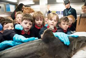
Children from Rang 2 at Scoil Shéamais Naofa in Bearna got up close and personal with sharks on the RV Celtic Explorer as part of the Marine Institute’s outreach and engagement programme.
The pupils completed a project module on sharks in Irish waters as part of the Marine Institute’s Explorers Education Programme, and also had the opportunity to visit the State research vessel.
Outreach officer Padraic Creedon of the Explorers Education Programme said one if the programme’s unique elements “is the content and support provided to teachers in the classroom in an easy and fun way.
“The students were inspired by the discovery of a rare shark nursery 200 miles off the west coast of Ireland in 2018, and we were delighted to create lessons, interactive experiments and discussion about the ocean, sharks and their environment for the class.”
While on board the RV Celtic Explorer, pupils met with the captain and scientists and saw what it might be like to work on a research vessel.
Students spoke with Captain Denis Ronan about the Celtic Explorer, and learn more about the acoustically silent ship that can stay out at sea for up to 35 days.
The pupils were excited to tour the vessel and speak with marine scientists to discover more about shark species, seabed mapping, shipwrecks and the marine environment.
Visiting the dry and wet labs, the pupils saw various fish species from recent surveys and shark species, such as dogfish and the tope shark.
Clár Ní Bhraonáin, teacher at Scoil Shéamais Naofa, said: “It has been an amazing experience … Students don’t forget days like this.”
The Explorers programme offers a range of materials including lesson plans to conduct experiments in class, watching films that helps generate discussion, and peer learning among pupils.
“Because of the students’ enthusiasm to learn more about sharks, we have been able to incorporate marine themes across the curriculum, where they have excelled and produced some incredible work, from writing books about sharks to a series of posters and artwork,” Ní Bhraonáin added.
“This project has really helped myself and the students learn more about the ocean.”
For more information on the Explorers Education outreach centres, visit the Explorers Contacts page at Explorers.ie. The programme is supported by the Marine Institute and is funded under the Marine Research Programme by the Government.
The annual Anglerfish and Megrim Survey has begun off the West South West and South Coasts of Ireland in fulfilment of Ireland’s Common Fisheries Policy obligations.
The purpose of this project is to carry out annual survey for relative annual abundance and distribution of anglerfish and megrim. However, other species of national
importance will also be sampled, along with physical and chemical oceanographic parameters.
IAMS 2019 runs till Monday 25 March. The demersal trawl survey consists of around 110 otter trawls (of 60 minutes each) in ICES areas 7b, 7c, 7g, 7h, 7j and 7k as indicated the map below.
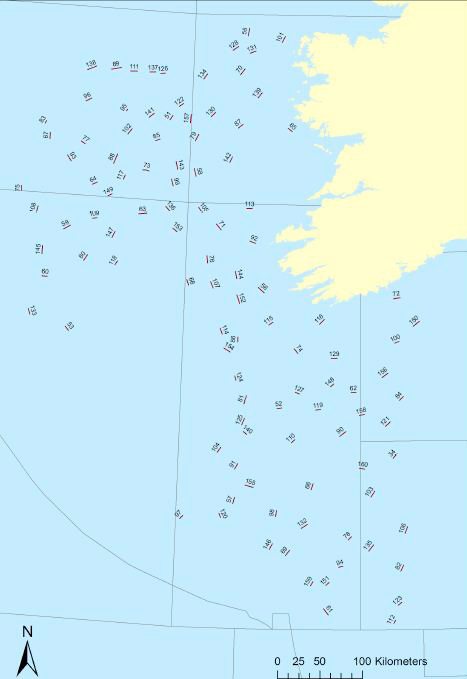
Fishing in 2019 will take place within a three-nautical-mile radius of all positions indicated.
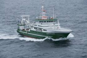
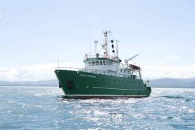
The survey will be conducted by the RV Celtic Explorer (Callsign: EIGB). The vessel will display all appropriate lights and signals during the survey and will also be listening on VHF Channel 16. The vessel will be towing a Jackson demersal trawl during fishing operations.
Commercial fishing and other marine operators are requested to keep a 3nm area around the tow points clear of any gear or apparatus during the survey period. For more details see Marine Notice No 6 of 2019, a PDF of which is available to read or download HERE.
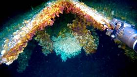
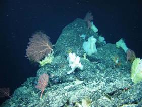
Shipwrecks off the Irish coast are acting as artificial reefs for corals usually found much deeper in the Atlantic.
That’s according to NUI Galway ocean scientist Anthony Grehan, who told the Irish Examiner about his recent surprising find at the wreck of a cargo vessel 160 metres below the surface.
Using the new submersible robot Étáin from the University of Limerick, Grehan and a team on the RV Celtic Explorer found examples of the stony coral species lophelia pertusa, which usually found at depths of 500 metres or more.
And the new discovery suggests that such wrecks may provide the necessary stability for deep-water corals to thrive in shallower waters.
The Irish Examiner has much more on the story HERE.
Schools Encouraged To Engage With Science On New Atlantic Ocean Seismic Mission
#MarineScience - The new mission to Ireland’s offshore reaches to monitor seismic activity on the North Atlantic floor is to engage with schools while at sea.
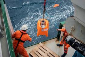
As previously covered on Afloat.ie, scientists from the Dublin Institute for Advances Studies (DIAS) departed last Monday 17 September, on board the RV Celtic Explorer, for the three-week voyage that will see them deploy a network of 18 seismometers as part of the SEA-SEIS project.
Daniel Farrell is reporting on their work via the RV Celtic Explorer’s blog Scientists@Sea.
“I am looking forward to sharing first-hand what it’s like being on a research vessel such as the RV Celtic Explorer,” says Farrell, of CoastMonkey.ie and sponsored by DIAS and the Marine Institute.
“I have a passion for the sea, and will be filming the scientists, writing content for the blog as well as taking photos of all of the activities where everyone can keep up to date with what is happening.”
Students and teachers can engage with the mission through Farrell’s blog posts as well as with a range of resources and videos available on the SEA-SEIS website.
“The SEA-SEIS team have also organised a range of activities that both primary and secondary schools can take part in over the next couple of months,” Farrell adds.
“There are teaching resources and lesson plans from the Explorers Education Programme, as well as some great competitions involving a drawing competition and composing a rap song.”
New Project To Uncover Secrets Of Ireland’s Offshore Ocean Floor
#MarineScience - Researchers from the Dublin Institute for Advances Studies (DIAS) departed Cobh yesterday (Monday 17 September) on the RV Celtic Explorer with a mission to monitor seismic activity on the North Atlantic Ocean floor.
As Silicon Republic reports, the SEA-SEIS project will deploy 18 seismometers over the next three weeks to form a network that will cover Ireland’s offshore area.
These sensors will collect data over the next two years, measuring tiny vibrations from seismic and ocean waves that will inform 3D models to unveil the mysteries below the sea bed.
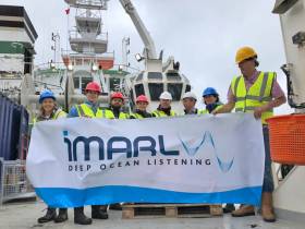
DIAS is partnering with the Marine Institute, Geological Survey of Ireland, Science Foundation Ireland and Irish Centre for Research in Applied Geosciences (iCRAG) on the SEA-SEIS mission that will use acoustic sensors developed by the iMARL deep ocean listening project.
“The geological evolution of Ireland’s offshore territory is fascinating, but there is still so much of it to be explored,” said Prof Chris Bean, a specialist in geophysics at DIAS.
He added the SEA-SEIS project means that for the first time “we will be able to make long-term direct observations of the interactions between our oceans and solid Earth in this region.”
Silicon Republic has more on the story HERE.
Big Presence For INFOMAR At Major Seabed Mapping Conference
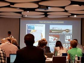
#MarineScience - The extensive work carried out jointly by the Marine Institute and Geological Survey Ireland through the INFOMAR programme received substantial exposure and recognition at the 16th Forum for the Exchange of Mutual Multibeam Experiences (FEMME) in Bordeaux last week.
Hosted by the Kongsberg Maritime User Forum and focussing on seabed mapping, FEMME provides an international platform for hydrographic professionals to meet, exchange experiences and ideas, provide inspiration and contribute to improved system performance and the future of underwater mapping technologies.
High-profile attendees include the secretary general of the International Hydrographic Organization (IHO), chief hydrographers from the Service Hydrographique et Océanographique de la Marine (SHOM), and Seabed 2030 leaders.
An overview of the Department of Communications, Climate Action and Environment-funded INFOMAR programme was provided by Dr Fabio Sacchetti, who updated the audience on future plans as well as recent achievements of the Irish national seabed mapping initiative.
Dr Sacchetti highlighted 10 case studies featuring multiple applications of multibeam technologies in support of sectors including coastal engineering, marine conservation and marine heritage and tourism.
In addition, a recent high-profile collaboration between INFOMAR and various US and Canadian research institutes was presented by international research partners in attendance.
INFOMAR featured prominently in a talk by Prof John Hughes Clarke (CCOM/University of New Hampshire) when describing research into the impact of internal wave activity on multibeam bathymetry in an Irish/Celtic Sea context, based on work conducted onboard the RV Celtic Explorer.
Prof Clarke has been collaborating with INFOMAR since 2015, and he is particularly focused on using hydrographic and fisheries sonar systems, combined with oceanographic data, to gain a deeper understanding of the dynamics and complexities of the Celtic Sea.
Jose Cordero, of Instituto Hidrografico dela Marina (Spain), demonstrated how improved sound speed control through remotely detecting thermocline undulations can be achieved.
The study was the result of a collaboration carried out in 2017 onboard the RV Celtic Explorer during a routine INFOMAR survey.
Finally, Anand D Hiroji (HSRC/University of Southern Mississippi) showed how unambiguous radiation pattern extraction methods can improve data derived from multisector multibeam Sonars. Once again, this study was carried out using data acquired by INFOMAR onboard the RV Celtic Explorer.
As Ireland continues toward completion of its seabed mapping programme in 2026, the Marine Institute says it is “widely acknowledged internationally” that our best practice approach towards open and integrated data acquisition, integration and exploitation “is a valued model, and one which gives Irish researchers and technology developers a global audience, and market.”
#MarineScience - A UCC-led group of scientists from across the globe have revealed a submarine canyon on the edge of Ireland’s continental shelf, 320km west of Dingle, after mapping an area twice the size of Malta.
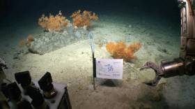
The group returned last Friday (10 August) after a research expedition on board the Marine Institute’s RV Celtic Explorer with ROV Holland I, mapping 1,800 sqkm of seabed to image the upper canyon over a fortnight.
Scientists say the find is significant in understanding more about how submarine canyon helps transport carbon to the deep ocean.
Although there is excess CO2 in the atmosphere (the greenhouse effect), the ocean is absorbing this at the surface, and canyons pump this into the deep ocean where it cannot get back into the atmosphere.
The expedition, led by Dr Aaron Lim of UCC’s School of Biological, Earth and Environmental Sciences (BEES), utilised the Marine Institute’s remotely operated vehicle (ROV) Holland I and state-of-the-art mapping technologies to learn more about the nature of the canyon.
“This is a vast submarine canyon system, with near-vertical 700m cliff in places and going as deep as 3,000m. You could stack 10 Eiffel towers on top of each other in there,” Dr Lim said. “So far from land this canyon is a natural laboratory from which we feel the pulse of the changing Atlantic.”
According to Dr Lim, this discovery coupled with recent findings on the Irish-Atlantic margin – including rare sponge reefs and a spectacular mountain range in the mid-Atlantic – shows the advances in both Ireland’s marine technology and scientific workforce. “Ireland is world-class, and for a small country we punch above our weight,” he said.
The Porcupine Bank Canyon is the westernmost submarine canyon on the contiguous Irish margin 320km west of Dingle and exits onto the abyssal plain at 4,000m water depth. The upper canyon is full of cold-water corals forming reefs and mounds which create a rim on the lip of the canyon 30m tall and 28 km long.
The coral reefs on the rim of the canyon eventually break off and slide down into the canyon, where they form an accumulation of coral rubble deeper within the canyon.
The ROV ventured deeper into the canyon and found significant build-ups of coral debris that have fallen from hundreds of meters above.
“This is all about transporting carbon stored cold water corals into the deep. The corals get their carbon from dead plankton raining down from the ocean surface so ultimately from our atmosphere,” said Prof Andy Wheeler of the School of BEES at UCC and the Irish Centre for Research in Applied Geosciences (iCRAG).
“Increasing CO2 concentrations in our atmosphere are causing our extreme weather; oceans absorb this CO2 and canyons are a rapid route for pumping it into the deep ocean where it is safely stored away.”
The new detailed maps show lobes of sediment debris and the scars from submarine slides as the canyon walls collapse. There is also exposure of old crustal bedrock and incised channels in the canyon floor carved by sediment avalanches.
“We took cores with the ROV Holland I and the sediments reveal that although the canyon is quiet now, periodically it is a violent place where the seabed gets ripped up and eroded,” Prof Wheeler added.
The new mapping data shows a rim feature along the lip of the canyon at approximately 600m water depth.
“When we sent down the ROV, we saw that this rim is made of a profusion of cold water corals, which appears to extend for miles along the edge of the canyon,” said Prof Luis Conti of the University of Sao Paulo, Brazil.
The research supports the shared vision of the Atlantic Ocean Research Alliance, which includes the ongoing cooperation on ocean science and observation in the Atlantic Ocean.
The research has been funded by Science Foundation Ireland, Geological Survey Ireland and contributes to projects in the iCRAG. This research survey was also carried out with the support of the Marine Institute, funded under the Marine Research Programme 2014-2020 by the Irish Government.
Prof Wheeler’s Marine Geology Research Group in the UCC School of BEES is undertaking a research project to monitor the range of coral habitats within this canyon with the aim of understanding what drives these habitats, how they change through time and how sensitive they are to disturbances.
Shiptime Charter Applications For 2019 & 2020 Now Open
#MarineScience - Applications are open for shiptime in 2019 and 2020 on Ireland’s national research vessels Celtic Explorer and Celtic Voyager, as well as the ROV Holland I and the Laochra na Mara glider.
Every year a broad range of organisations use the Marine Institute’s vessels for research, development and monitoring programmes. These include Government departments and agencies, universities, research institutes and industry.
Applications for shiptime for 2019 and 2020 must be submitted using Research Vessel Operations’ online Survey Planning System (SPS) by Thursday 20 September. Please contact Research Vessel Operations to obtain an SPS login if you don’t already have one and to inquire about glider availability.
Each application will be reviewed and the applicant will be informed as soon as possible whether the shiptime they requested is available. If the requested shiptime is not available, alternative dates may be offered. The Vessel Charter Guidelines should be read carefully before submitting the ship time application form.
Applicants may seek grant aid to cover all or part of the vessel charter costs for research surveys or ship-based Training Programmes. The closing date for receipt of grant aid applications is 5pm on Friday 21 September.
Applicants for ship-based training are advised to consult with the Strategic Marine Alliance for Research and Training (SMART) at [email protected].
The survey schedules can change during the year, therefore please contact Research Vessel Operations to check whether any survey slots remain for 2018 or to be notified if any dates become available.
#MarineScience - A multinational team of ocean exploration experts returned to Galway on World Ocean Day (Friday 8 June) after spending the last few weeks exploring and mapping the Charlie-Gibbs Fracture Zone of the Mid-Atlantic Ridge.
Using the robotic mini-sub ROV Holland I, the TOSCA (Tectonic Spreading and the Charlie-Gibbs Fracture Zone) research team led by Dr Aggie Georgiopoulou of UCD collected “spectacular” film footage of sponge gardens.
In another first for deep-sea exploration, the marine science team on board the RV Celtic Explorer also found more than 70 skate eggs in a nursery some 2,000 metres below the surface.
“Up to 150 rock and sediment samples amounting to roughly 200kg along with 86 hours of video footage and over 10,000 square kilometres of the zone were also mapped, which is almost the size of Co Galway and Co Mayo together,” Dr Georgiopoulou said.
The Charlie-Gibbs Fracture Zone was mapped for the first time in 2015 on the RV Celtic Explorer as one of the key projects launched by the Atlantic Ocean Research Alliance, following the signing of the Galway Statement on Atlantic Ocean Cooperation between Canada, the EU and the US in May 2013.
“The high resolution data produced by Ireland’s INFOMAR programme in 2015, that revealed spectacular landscape with 4,000m-high mounds rising from the seabed to 600m below the sea surface — taller than Carrauntoohil, Ireland’s highest mountain — has been instrumental in our continued research over the last month,” Dr Georgiopoulou said.
The tectonic spreading at the Charlie-Gibbs Fracture Zone consists of two huge parallel cracks in the crust of the Atlantic Ocean running between Ireland and Newfoundland, and is the longest-lived fracture zone in the Atlantic. It is the most prominent feature interrupting and offsetting the Mid-Atlantic Ridge.
“What we have found at the Charlie-Gibbs Fracture Zone surpassed all of our expectations,” Dr Georgiopoulou added. “Exploring three mountain areas, 500-1,000m-high scarps were discovered that have been produced by catastrophic rock avalanches, with giant boulder fields spilling into the fractures.
“Although these fracture zones are similar to the San Andreas fault in the western US and the North Anatolian fault in Turkey and Greece, with large earthquakes taking place there regularly, this is the first time there has been a dedicated geological study in the Charlie-Gibbs Fracture Zone area.”
The TOSCA expedition involved 13 scientists from nine institutions and five different countries including Ireland, the UK, Germany, Canada and Greece.
Experts in seabed mapping, marine geology, oceanography and marine biology, each team will return to their respective Institutes to analyse all the data and work out how the mountains were formed, when and how the rock avalanches take place and how the geology affects the local habitat for marine wildlife.
Marine Institute chief executive Dr Peter Heffernan congratulated the team on their recent discoveries, stating that deep ocean expeditions cannot be taken for granted as we need to better understand the features that make up the ocean seabed.
“With the ocean affecting climate change, global population and seafood demand, we need to map our seabed to define favourable habitats for fishing, key sites for conservation, and safe navigation for shipping.
“The expedition supported by AORA also reflects the value and essential role of international partnerships, particularly with achieving the shared goals of the Galway Statement on Atlantic Ocean Cooperation 2013, which include our ongoing cooperation on ocean science and observation in the Atlantic Ocean,” Dr Heffernan said.
#MarineScience - As many as 12 artists, writers and musicians from Ireland and Europe have the opportunity to join expeditions on the research vessel RV Celtic Explorer and to work with marine scientists as part of an interdisciplinary art project for radio broadcast.
The three-year AerialSparks project will explore the potential of radio communication as a means to rethink our ocean wilderness as one of the last remaining unknowns.
AerialSparks has been created by artist Louise Manifold for Galway’s European Capital of Culture programme in 2020. Inspired by the concept of traditional broadcasting and the use of sonar and other technology for data collection, the project will result in a series of art works for radio.
Manifold, who previously worked with Galway schoolchildren on marine science and art projects, has commissioned artists from Ireland and Europe to develop new work based on their experiences of spending time at sea on research surveys carried out by the Marine Institute's research vessel, RV Celtic Explorer.
The Galway-born conceptual artist, currently on residency in Berlin, is keen to tap into the connections between radio as a communication and navigation tool, and discover how radio can make spaces visible to audiences.
“While at sea on the Explorer last year, I was extremely mindful of how radio can be listened to in solitude, yet bring people together providing a sense of togetherness,” she said. “It is amazing to think how early radio technology must have felt for many people bridging the distance of the ocean and bringing people together. Recognising the importance of technology, it continues to play a big part in how we understand the influences of the ocean.”
Taking part in the project are renowned artists David Stalling, Kennedy Brown, Carol Anne Connelly and Ailís Ní Riain, who will each spend up to two weeks at sea on the RV Celtic Explorer during scientific expeditions.
One of the surveys, overseen by Prof Andy Wheeler from UCC, includes monitoring deep-water coldwater corals reefs off the continental shelf, exploring the processes involved in understanding the coral habitats and sensitivity to climate change and human impacts.
The artists will have the opportunity to record data where advanced robotic technology and 3D visualisation tools will be used on the ROV Holland I at depths of 3,000m under the water.
Ireland’s offshore territory is 10 times the size of our land area, and marine research projects involving new technology help us learn more about the land under the sea, its geology and processes and how this impacts our lives.
Artists will also get to work with Prof Sergei Lebedev from the Dublin Institute for Advanced Studies (Dias), where research is being conducted looking at offshore earthquakes in the deepest parts of Ireland’s ocean.
With scientific equipment being deployed for the first time from the RV Celtic Explorer, including 18 ocean-bottom seismometers and an array of acoustic sensors, the survey will explore marine activity that can trigger undersea landslides.
Hannah Kiely, chief executive of Galway 2020, said of the project: “We are very excited about the waves of possibilities that the collaboration between arts and science presents particularly given the project’s focus on histories of the ocean voyage, maritime radio communication and how this might be felt and understood in a digital age. With our aim to be the first truly Virtual European Capital of Culture, digital is at the heart of our programme for Galway 2020.”
The ocean covers over 70 percent of the planet’s surface and with the advancement of marine technology, new discoveries are being made every day.
Marine Institute chief executive Dr Peter Heffernan added: “Aerial Sparks is an innovative opportunity for artists and marine scientists to learn new ways to connect and engage with the wider community.
“We are learning more about the ocean including new habitats being explored for the first time, new species being discovered, as well as the effects of climate change and understanding the impacts humans are having on the ocean.
“Therefore, increasing our awareness and narrative about the ocean is extremely important. Using the concept of sound and the sea is a unique way of showing how both the arts and sciences highlight the importance of exploration and curiosity.”
The Marine Institute is also hosting a series of lunchtime talks at its Galway headquarters for scientists, giving them the opportunity to meet artists working on the project, and to be introduced to their ideas, processes and future work for AerialSparks. For further information contact the research operations office at the Marine Institute.
AerialSparks is funded by the Arts Council of Ireland Project Awards, Galway 2020 and the Marine Institute.


