


Displaying items by tag: IGFS
2023 Irish Groundfish Survey Set to Begin Later This Month
The annual Irish Groundfish Survey (IGFS) for 2023 will be carried out by the Marine Institute off the North West, West and South Coasts of Ireland from Tuesday 31 October to Saturday 16 December.
The IGFS is a demersal trawl survey consisting of approximately 170 fishing hauls of 30-minute duration each in ICES areas VIa, VIIb, VIIg and VIIj.
Fishing will take place within a two-nautical-mile radius of the positions indicated in the appendices to Marine Notice No 68 of 2023, which can be downloaded below.
The survey will be conducted by the RV Celtic Explorer (callsign EIGB) which will display appropriate lights and signals. The vessel will be towing a high headline GOV 36/47 demersal trawl during fishing operations.
The Marine Institute requests that commercial fishing and other marine operators keep a two-nautical-mile area around the tow mid-points clear of any gear or apparatus during the survey period outlined above.
Further details can be found in the Marine Notice attached below.
2022 Irish Groundfish Survey Set to Begin Next Week
The annual Irish Groundfish Survey (IGFS) for 2022 will be carried out by the Marine Institute off the North West, West and South Coasts of Ireland from next Monday 31 October to Friday 16 December.
The IGFS is a demersal trawl survey consisting of approximately 170 fishing hauls of 30-minute duration each in ICES areas VIa, VIIb, VIIg and VIIj.
Fishing will take place within a two-nautical-mile radius of the positions indicated in the appendices to Marine Notice No 73 of 2022, which can be downloaded below.
The survey will be conducted by the RV Celtic Explorer (callsign EIGB) which will display appropriate lights and signals. The vessel will be towing a high headline GOV 36/47 demersal trawl during fishing operations.
The Marine Institute requests that commercial fishing and other marine operators keep a two-nautical-mile area around the tow mid-points clear of any gear or apparatus during the survey period outlined above.
Further details can be found in the Marine Notice attached below.
Marine Institute’s Fisheries Research Features in Euronews Documentary
Fisheries research undertaken by Marine Institute scientists features in a new short documentary from Europe's leading international news channel.
Produced by Euronews, ‘Where’s the catch? The fishery surveys keeping our seas sustainable’ follows the RV Celtic Explorer during the annual Irish Groundfish Survey (IGFS), which most recently took place from October to December 2021.
This six-week fisheries survey in Ireland’s Atlantic shelf takes place each year, with the survey passing through 170 points on the nautical chart.
The IGFS assesses commercially exploited fish stocks, such as haddock and whiting. The survey provides an index of the share of young fish in the stock, which in turn gives an indication of its spawning success.
In the video, David Stokes of the Marine Institute, and chief scientist on the IGFS, explains the sampling processes and the survey’s importance, while scientists Jennifer Doyle and Sinead O’Brien discuss what data is collected in the research vessel’s laboratory.
This Irish survey is one of many conducted in a coordinated way along the northern and western coasts of the European continent. The data collected from all surveys is compiled and analysed by the International Council for the Exploration of the Seas (ICES).
Dr Ciaran Kelly, director of fisheries, ecosystems and advisory services at the Marine Institute, said: “We are delighted for our work to be featured in this Euronews documentary, as Marine Institute scientists play a key role in carrying out assessments and developing the scientific evidence and advice at ICES.
“The important scientific work undertaken by our scientists is essential for supporting a sustainable ocean economy, as well as protecting and managing our marine ecosystems.”
The video is part of the monthly ‘Ocean’ series produced by Euronews and the European Commission, which is broadcast in nine languages and available in 160 countries.
2021 Irish Groundfish Survey Set for Later This Month
The annual Irish Groundfish Survey (IGFS) for 2021 will be carried out by the Marine Institute off the North West, West and South Coasts of Ireland from Saturday 30 October to Tuesday 14 December.
The IGFS is a demersal trawl survey consisting of approximately 170 fishing hauls of 30-minute duration each in ICES areas VIa, VIIb, VIIg and VIIj.
As part of the requirements for the 2021 survey, fishing will take place within a two-nautical-mile radius of the positions indicated in the appendices to Marine Notice No 57 of 2021, which can be downloaded below.
The survey will be conducted by the RV Celtic Explorer (callsign EIGB) which will display appropriate lights and signals. The vessel will be towing a high headline GOV 36/47 demersal trawl during fishing operations.
The Marine Institute requests that commercial fishing and other marine operators keep a two-nautical-mile area around the tow mid-points clear of any gear or apparatus during the survey period outlined above.
Further details can be found in the Marine Notice attached below.
Groundfish Survey Off South & West Coasts Ongoing Till December
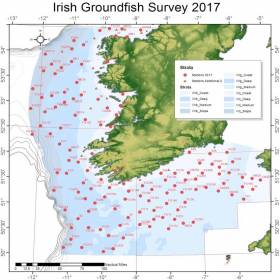
#MarineNotice - The Marine Institute advises that the annual Irish Groundfish Survey (IGFS2017) is being carried out off the South and West coasts of Ireland till Saturday 9 December in fulfilment of Ireland's Common Fisheries Policy obligations.
The IGFS is a demersal trawl survey consisting of approximately 125 fishing hauls of 30 min duration each in ICES area VIIb, VIIg and VIIj.
Fishing in 2017 is taking place within a two nautical mile radius of these indicative positions, the approximate locations of which are noted in Marine Notice No 55 of 2017.
As with last month's survey off the North West, the operation is being conducted by the RV Celtic Explorer (Callsign EIGB).
The vessel is displaying all appropriate lights and signals during the survey and is also listening on VHF Channel 16. It is towing a high headline GOV 36/47 demersal trawl during fishing operations.
Commercial fishing and other marine operators are requested keep a two nautical mile area around the tow points clear of any gear or apparatus during the survey period.
Groundfish Survey Off North West Coast This October
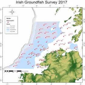
#MarineNotice - The Marine Institute advises that the annual Irish Groundfish Survey (IGFS2017) will be carried out off the North West Coast of Ireland between Tuesday 3 and Saturday 14 October, in fulfilment of Ireland’s Common Fisheries Policy obligations.
The IGFS is a demersal trawl survey consisting of approximately 45 fishing hauls of 30 minutes duration each in ICES area VIa. Fishing in 2017 will take place within a two nautical mile radius of these 45 positions, the approximate locations of which are noted in Marine Notice No 39 of 2017.
The survey will be conducted by the RV Celtic Explorer (Callsign: EIGB), which will display all appropriate lights and signals during the survey and will also be listening on VHF Channel 16. The vessel will be towing a high headline GOV 36/47 demersal trawl during fishing operations.
This survey is to determine the relative annual abundance and distribution of commercially exploited fish stocks, in particular assessment of recent recruitment. In addition, other species of national importance are sampled along with physical and chemical oceanographic parameters.
The Marine Institute requests that commercial fishing and other marine operators keep a two nautical mile area around the tow points clear of any gear or apparatus during the survey period outlined above.
While there is no statutory provision for the loss of gear at sea, the Marine Institute will make every effort to avoid gear, adequately marked according to legislation, that may be encountered in the notified areas. In the event that an operator has static gear or other obstructions within 2nm of the trawl points, it is the responsibility of the owner to notify the survey managers or vessel directly.
This should be communicated by identifying specifically which ‘Prime Station’ is of concern using the appendix and contact details provided in Marine Notice No 39 of 2017, a PDF of which is available to read or download HERE.
It is not required to provide positional details of commercial operations beyond 3-4nm of the survey points provided. Specifics of any fishing gear or other obstructions that are known and cannot be kept clear of these survey haul locations can be notified using the contact details provided in the above Marine Notice.
Marine Notice: Annual Groundfish Survey Off South & West Coasts
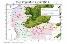
#MarineNotice - The Marine Institute advises that the annual Irish Groundfish Survey (IGFS2016) will be carried out off the South and West coasts of Ireland between Monday 14 November and Sunday 18 December in fulfilment of Ireland’s Common Fisheries Policy obligations.
The IGFS is a demersal trawl survey consisting of a minimum of 125 fishing hauls of 30 minutes duration each. Fishing in 2016 will take place within a 2nm radius of the positions indicated in Marine Notice 44 of 2016, available to read or download HERE.
The survey will be conducted by the RV Celtic Explorer (Callsign EIGB), which will display all appropriate lights and signals during the survey and will also be listening on VHF Channel 16. The vessel will be towing a high headline GOV 36/47 demersal trawl during fishing operations.
The Marine Institute requests that commercial fishing and other marine operators keep a 2nm area around the tow points clear of any gear or apparatus during the survey period.
While there is no statutory provision for the loss of gear at sea, the Marine Institute will make every effort to avoid gear adequately marked according to legislation that may be encountered in the notified areas.
In the event that an operator has static gear or other obstructions within 2nm of the points listed above it is the responsibility of the owner to notify the survey managers or vessel directly. This should be communicated by identifying specifically which ‘Prime Station’ is of concern using the appendix and contact details provided in the Marine Notice. It is not required to provide positional details of commercial operations beyond 3-4nm of the survey points provided.
Specifics of any fishing gear or other obstructions that are known and cannot be kept clear of these survey haul locations can be notified using the contact details provided in the Marine Notice.
Marine Notice: Denersal Groundfish Survey Off Northwest Coast
#MarineNotice - A new Marine Notice from the Department of Transport, Tourism and Sport (DTTAS) advises that the annual Irish groundfish survey will be take place off the northwest coast from 19-30 September.
Carried out by the Marine Institute in fulfilment of Ireland’s CFP (Common Fisheries Policy) obligations, IGFS 2015 is a demersal trawl survey consisting of a minimum of 45 fishing hauls each of 35 minutes duration.
The survey will be conducted by the RV Celtic Explorer (Callsign EIGB), which will display all appropriate lights and signal during the survey and will also be listening on VHF Channel 16. She will be towing a high headline GOV 36/47 demersal trawl during fishing operations.
The Marine Institute requests commercial fishermen to keep a 2-nautical-mile area around the tow points clear of all commercial gear during the period/. While there is no statutory provision for the loss of fishing gear, the Marine Institute will make every effort to avoid gear adequately marked, according to legislation, that may have drifted into the notified areas.
In the event that a fisherman has static gear or other obstructions within 2nm of the points listed in Marine Notice No 43 of 2015, it is the responsibility of the owner to notify the survey managers or vessel directly using the contact information provided.
Full details of the survey area are available as a PDF to read download HERE.


 with (from left) the Marine Institute’s Fiona Grant, Dr Niall McDonough and Joe Silke during her visit to the institute’s Galway headquarters on Friday 5 April")


 Michael Murphy Schull Harbour Sailing Club (SHSC), Eric Coogan Heineken Ireland, Mark Murphy, Commodore SHSC, Jack Allen SHSC, Carmel O'Regan SHSC, Cornelious Ndlovu, Schull Harbour Hotel Operations Manager and Derval Murphy SHSC")


