


Displaying items by tag: RV Celtic Explorer

#MarineNotice - Hydrographic and geophysical surveys will be undertaken in the Celtic Sea and Atlantic Ocean under the INFOMAR (Integrated Mapping for the Sustainable Development of Ireland’s Marine Resources) programme until October 2018.
Geological Survey Ireland vessels the RV Keary (Callsign EI-GO-9), RV Geo (Callsign EI-DK-6), RV Tonn (Callsign EI-PT-7), RV Mallet (Callsign EI-SN-9) and RV Lir (Callsign EI-HI-2) are already involved in scheduled surveys since March.
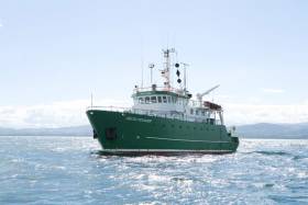
Marine Institute vessels the RV Celtic Explorer (Callsign EIGB) and RV Celtic Voyager (Callsign EIQN) will begin surveys this weekend, starting with the former vessel on a three-week survey from Sunday 22 April.
The Celtic Voyager and the Celtic Explorer will be towing a magnetometer sensor with a single cable of up to 200 metres in length. The vessels will display appropriate lights and markers, and will be listening on VHF Channel 16 throughout the course of the surveys.
Details of co-ordinates for these surveys are included in Marine Notice No 18 of 2018, a PDF of which is available to read or download HERE.
Note that the Atlantic Ocean Area may not be surveyed in 2018, but if for operational reasons the survey does take place, it will be during the dates set out above for the Celtic Voyager surveys listed therein. In that event, the Marine Notice will be updated with specific dates.
2018 Anglerfish & Megrim Survey Begins Today

#MarineNotice - The Marine Institute’s annual Irish Anglerfish and Megrim Survey (IAMS) for 2018 is scheduled to resume today, Tuesday 10 April.
After January's survey off the West and South Coasts, this month's survey will be carried out till Saturday 21 April off the North and North West Coasts of Ireland in fulfilment of Ireland’s Common Fisheries Policy obligations.
The IAMS is a demersal trawl survey consisting of approximately 50 otter trawls of 60 minutes duration in ICES area 6a. Fishing will take place within a three nautical mile radius of the positions indicated in Marine Notice No 15 of 2018, a PDF of which is available to read or download HERE.
Survey operations will be conducted by the RV Celtic Explorer (Callsign EIGB), which will display all appropriate lights and signals during the survey and will also be listening on VHF Channel 16.
The vessel will be towing a Jackson demersal trawl during fishing operations. The Marine Institute requests that commercial fishing and other marine operators keep a three nautical mile area around the tow points clear of any gear or apparatus during the survey period outlined above.
Specifics of any fishing gear or other obstructions that are known and cannot be kept clear of these survey haul locations can be notified using the contact details provided in the Marine Notice.
RV Celtic Voyager To Be Replaced As Part Of National Development Plan

#MarineScience - The Government’s new National Development Plan includes provision for a new marine research vessel to replace the RV Celtic Voyager, according to The Irish Times.
Marine Institute chief executive Dr Peter Heffernan says work is at an “advanced stage” towards confirmation of the project, which would see the 31-metre Celtic Voyager — which has served for two decades — replaced with a vessel of around 50 metres in length.
The new ship would serve alongside the RV Celtic Explorer, which recently underwent a major refit, as previously reported on Afloat.ie.
Refit of RV Celtic Explorer Leads to a Renewed Start in 2018
#MarineScience - Research vessel RV Celtic Explorer of the Marine Institute, is off to a renewed start in 2018, after undergoing a major refit.
The Romanian-Dutch built ship is ready to accommodate 18 scientific surveys throughout the year.
The five-year refit included an overhaul of the bow thruster and an upgrade of its DC propulsion system. The vessel's original fishing sonar was removed and a new Simrad SU92 fisheries sonar installed. The new sonar will have an increased range and resolution and a decreased noise level, which will be a huge advantage for the Marine Institute's fisheries research.
The vessel's accommodation also received an upgrade after 15 years of service with cabin floors refurbished and a new accommodation layout in the scientists cabins. The RV Celtic Explorer's refit also included painting and antifouling of the hull and complete painting of the superstructure as well as a major 60,000 hour overhaul of one of its main diesel generators .
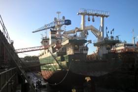
The 65.5m vessel was in A&P yard in Falmouth, United Kingdom for the refit which started in mid in December 2017 and works were completed this month.
The RV Celtic Explorer came into service in 2003 and is designed for fisheries acoustic research, oceanographic, hydrographic and geological investigations as well as buoy/deep water mooring and ROV Operations.
Several deepwater ROV surveys will be undertaken in 2018, one led by Dr Louise Allcock from the National University of Ireland, Galway will investigate deep sea corals and sponges from a diversity of deep-water habitats.
Professor Andrew Wheeler from the University College Cork will explore and monitor cold water corals in the submarine canyons in the deep ocean and determine their sensitivity to climate change, fisheries and oil industry impacts.
A survey led by Professor Sergei Lebedev from the Dublin Institute for Advanced Studies will investigate the structure, evolution and seismic hazard of Ireland's offshore territory. Professor Lebedev's team will for the first time, deploy an array of ocean-bottom, broadband seismometers offshore, which together with existing arrays onshore will cover the entire Irish territory.
Dr Aggeliki Georgiopoulou from the University College Dublin will survey the structure and composition of the lower crust and mantle, as well as any hydrothermal activity RV Celtic Explorer off to a renewed start in 2018 at the Charlie Gibbs Fracture Zone, the largest geological fault in the northern Mid-Atlantic Range.
In 2018 the Marine Institute will also undertake acoustic surveys of Anglerfish and Megrim, Blue Whiting, Celtic Sea Herring and Boarfish on the RV Celtic Explorer. An INFOMAR-led survey will also map the physical features of the seabed in the Celtic Sea, using hydrographic techniques.
To follow the voyages of the RV Celtic Explorer, visit the Marine Institute website to track a vessel or view the vessel schedule. A virtual tour of the RV Celtic Explorer can also be accessed from the Marine Institute website at www.marine.ie
Open Call For Training Through Research Surveys In 2018
#MarineScience - The call for applicants to take part in Training Through Research Surveys (TTRS) is now open to graduate and postgraduate students from across Ireland.
TTRS is a collaboration between the Strategic Marine Alliance for Research & Training (SMART) and the Marine Institute, which aims to increase national capacity in offshore marine research by providing placements on a range of dedicated research surveys.
TTRS surveys give students the opportunity to develop their careers in ocean science and gain hands-on research experience on board the Marine Institute’s research vessels, RV Celtic Explorer and RV Celtic Voyager.
Students can develop the skills required to work at sea including using advanced and up-to-date equipment and instrumentation as well as collecting and handling data.
Taking part in a TTRS survey enables students to establish new professional contacts with experienced scientists and researchers, as well as make a real contribution to the survey goals.
This year’s TTRS surveys are as follows:
- Anglerfish and megrim survey: Legs 1 (19-27 February), 2 (27 February-8 March), 3 (9-19 March) and 4 (10-20 April)
- Blue whiting acoustic survey (20 March-9 April)
- INFOMAR hydrographic survey (21 April-13 May)
- Western European Shelf Pelagic Acoustic Survey (WESPAS) Legs 1 (9-18 June) and 2 (3-24 July)
- Celtic Sea herring acoustic survey (7-27 October)
To take part in a TTRS survey, visit the Smart Sea School website and complete an online application form. To read previous participants' experience of TTRS, visit the SMART blog.
Applicants for Training Through Research Surveys:
- must hold a degree in marine-related science or technology or be in the final year of their undergraduate programme.
- must hold a valid ENG11 medical certificate and a Personal Survival Techniques (PST) certificate (STCW95).
- should have some prior seagoing experience.
Please note that ENG11 medical certificates must be renewed every two years and PST certification renewed every five years.
Information on obtaining medical and sea-survival certificates, and check lists for scientists embarking on national research vessels is available from the Vessel User Information page on the Marine Institute website.
TTRS participants are responsible for costs incurred in travelling to and from survey ports. For queries please contact [email protected].
TTRS surveys are supported by the Marine Institute. Grant-aided ship time is carried out under the Strategic Marine Research & Innovation Agenda of the Integrated Marine Plan for Ireland (Harnessing Our Ocean Wealth) under the Marine Research sub-programme of the Irish Government.
Participation in surveys is by kind agreement with the survey chief scientist. Applications are invited from graduate and postgraduate students of Ireland of Ireland higher education institutions.
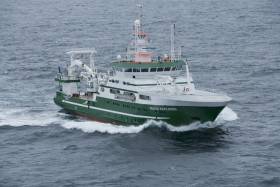
Groundfish Survey Off South & West Coasts Ongoing Till December
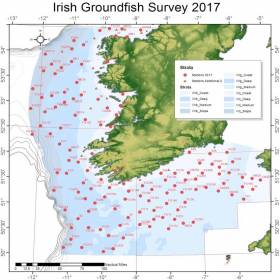
#MarineNotice - The Marine Institute advises that the annual Irish Groundfish Survey (IGFS2017) is being carried out off the South and West coasts of Ireland till Saturday 9 December in fulfilment of Ireland's Common Fisheries Policy obligations.
The IGFS is a demersal trawl survey consisting of approximately 125 fishing hauls of 30 min duration each in ICES area VIIb, VIIg and VIIj.
Fishing in 2017 is taking place within a two nautical mile radius of these indicative positions, the approximate locations of which are noted in Marine Notice No 55 of 2017.
As with last month's survey off the North West, the operation is being conducted by the RV Celtic Explorer (Callsign EIGB).
The vessel is displaying all appropriate lights and signals during the survey and is also listening on VHF Channel 16. It is towing a high headline GOV 36/47 demersal trawl during fishing operations.
Commercial fishing and other marine operators are requested keep a two nautical mile area around the tow points clear of any gear or apparatus during the survey period.
Groundfish Survey Off North West Coast This October
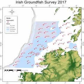
#MarineNotice - The Marine Institute advises that the annual Irish Groundfish Survey (IGFS2017) will be carried out off the North West Coast of Ireland between Tuesday 3 and Saturday 14 October, in fulfilment of Ireland’s Common Fisheries Policy obligations.
The IGFS is a demersal trawl survey consisting of approximately 45 fishing hauls of 30 minutes duration each in ICES area VIa. Fishing in 2017 will take place within a two nautical mile radius of these 45 positions, the approximate locations of which are noted in Marine Notice No 39 of 2017.
The survey will be conducted by the RV Celtic Explorer (Callsign: EIGB), which will display all appropriate lights and signals during the survey and will also be listening on VHF Channel 16. The vessel will be towing a high headline GOV 36/47 demersal trawl during fishing operations.
This survey is to determine the relative annual abundance and distribution of commercially exploited fish stocks, in particular assessment of recent recruitment. In addition, other species of national importance are sampled along with physical and chemical oceanographic parameters.
The Marine Institute requests that commercial fishing and other marine operators keep a two nautical mile area around the tow points clear of any gear or apparatus during the survey period outlined above.
While there is no statutory provision for the loss of gear at sea, the Marine Institute will make every effort to avoid gear, adequately marked according to legislation, that may be encountered in the notified areas. In the event that an operator has static gear or other obstructions within 2nm of the trawl points, it is the responsibility of the owner to notify the survey managers or vessel directly.
This should be communicated by identifying specifically which ‘Prime Station’ is of concern using the appendix and contact details provided in Marine Notice No 39 of 2017, a PDF of which is available to read or download HERE.
It is not required to provide positional details of commercial operations beyond 3-4nm of the survey points provided. Specifics of any fishing gear or other obstructions that are known and cannot be kept clear of these survey haul locations can be notified using the contact details provided in the above Marine Notice.
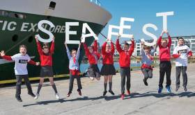
#SeaFest - Students from fourth class at Cregmore NS recently visited the RV Celtic Explorer in Galway Docks as part of their marine science and art project building up to SeaFest, Ireland’s national maritime festival.
Afloat.ie previously reported on the project, which places art, marine science and technology in the heart of the classroom in a re-enactment of the discovery of the Moytirra deep-sea hydrothermal vents in 2011.
On board the RV Celtic Explorer, up to 20 pupils experienced what it might be like to participate in an expedition at sea, as well as witness first-hand some of the equipment used in deep-sea exploration.
During the tour, led by Rosemarie Butler and Cushla Dromgool-Regan of the Marine Institute, the children learned about the recent climate survey of the mid-Atlantic and met with marine scientist Dr Louise Allcock of NUI Galway, who is studying cold water corals and sponges off the Irish continental shelf.
The students were also introduced to Paddy O’Driscoll, pilot of the unmanned ROV Holland I, who gave a live demonstration of how parts of the remotely operated submersible work.
“The enthusiasm the children showed about the ocean during their tour of the Celtic Explorer highlighted the importance of how school projects adopting different disciplines can be used in class in a very real and exciting way,” said Dromgool-Regan.
“The children’s high level of understanding about the ocean gained through the art and marine science project, where they discussed the geology of the ocean floor, concepts of climate change, along with deep sea creatures rarely seen by humans is a testament to the artists, scientists and teachers involved.”
Cregmore NS’s fourth class project, entitled Build Your Own Unknown, culminates with a film recreating the Moytirra vent discovery that will be premiered in the Kids Zone at Seafest 2017 before touring various education outreach centres around Ireland.
The RV Celtic Explorer will also be in Galway Docks for SeaFest with free tours available over the weekend from Friday 30 June to Sunday 2 July.
Visitors can keep track of all the activities taking place over the three-day festival with he new SeaFest Festival Guide app for iOS and Android devices.
Covering all of the events at the festival, the app contains the full programme of events, maps and directions, latest news, visitor info and social media feeds.
It also features an interactive 'My Favourites' list where users can add in their preferred festival events and create their own unique 'My Map' with all of the locations.
Snap-happy festival-goers can enter the Gallery Competition on the app by uploading a photo of their time at SeaFest — two lucky entrants will win a €100 One4All gift card.
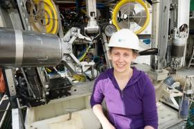
#MarineScience - Marine scientist and researcher Dr Louise Allcock from NUI Galway is leading a team of 10 university researchers and students on a two-week deep-sea expedition researching cold water corals and sponges.
The team — who can be followed on the Scientists@Sea blog – are currently exploring the Whittard Canyon, located 200 nautical miles south-west of Ireland at the edge of the continental shelf in the Atlantic Ocean aboard the Marine Institute’s RV Celtic Explorer, which recently returned from a climate change ‘health check’ of the Atlantic.
And the researchers are making extensive use of the Marine Institute’s ROV Holland I, deployed into areas where the sea floor rapidly drops from around 300m down to 3,000m.
“The researchers and students are seeing for the first time corals and sponges covering an area around the Whittard Canyon, Porcupine Seabight, Gollum Channel and the Belgica Mounds in Irish waters,” said Dr Olivier Thomas, a professor of marine biodiscovery at NUI Galway and co-ordinator of the National Marine Biodiscovery Laboratory located at the Marine Institute.
Dr Allcock added: “Using the ROV’s robotic and lighting capabilities, we are able to manoeuvre the Holland I, which is comparable to the size of a mini-van, through the water, and use its arms and clasps, which are like hands, to take small samples of corals, sponges and other specimens from extremely hostile parts of the ocean floor where there is no natural light and tremendous ocean pressure.”
By analysing past research relating to sponges and corals, Dr Allcock explained that her team “are able to see that some species are better target groups than others in having antimicrobial or anti-cancer properties.
“Based on this information we are building mathematical models to predict the likelihood of any given species yielding a novel natural product, along with developing species distribution maps of corals and sponges on the deep-sea floor, so that we know the best places to go searching.”
When the research team returns from sea, they work with the national marine biodiscovery lab at the Marine Institute. The chemists at NUI Galway extract the chemical compounds from all of the samples of sponges and corals to see if they have drug-like characteristics such as anti-cancer or antimicrobial properties that can be used for novel drugs to combat human illnesses.
“Chemists involved in biodiscovery research only need small quantities of any organism to develop a new drug, because once a suitable compound is identified, it can be synthesised in the lab, which can then be used in drugs to combat human diseases,” said Dr Thomas.
The ROV Holland I provides high definition continuous video footage of the deep seafloor as it is being used to collect samples.
“Going back through footage after the expedition enables us to further analyse the location recording of all the corals and sponges,” said Dr Allcock. “This improves future predictions of where else we might find similar specimens and also allows us to provide data to inform conservation policy so that we make sure that important ‘hotspots’ rich in corals and sponges are preserved.”
Marine Institute chief executive Dr Peter Heffernan was enthusiastic about the mission’s prospects.
“These are exciting times to be a marine researcher as marine scientists around the world have discovered more species in the ocean in the last ten years than ever before, with an average of 2,000 new discoveries each year,” he said.
“In Ireland we are contributing to building on this wealth of valuable information and sharing the best available science and knowledge to inform decisions affecting the Atlantic Ocean.”
This survey is being undertaken as part of a five-year project on ‘Exploiting and conserving deep-sea genetic resources’ at NUI Galway, co-funded by the Science Foundation Ireland and Marine Institute.
The National Marine Biodiscovery Laboratory project brings together six of the country’s leading marine researchers across a range of disciplines from NUI Galway, University of Limerick and University College Cork to study how marine substances might in future be used to make ingredients for cosmetics, pharmaceuticals and functional foods.
Take A Virtual Tour On Board The Celtic Explorer
#RVCelticExplorer - Pay a visit on board Ireland’s national marine research vessel wherever you are, thanks to a new immersive 360-degree virtual tour of the RV Celtic Explorer courtesy of the Marine Institute.
Conor Purcell writes in New Scientist on the top attractions aboard the busy marine science vessel, including its wet and dry labs, the tech-filled bridge, its sensor-studded drop keel and even the chief scientist’s cabin.
The RV Celtic Explorer most recently returned from its ‘health check’ of the Atlantic Ocean, which suggests a greater penetration of CFCs in the deeper ocean since the late 1990s.
If this tour whets your appetite, you can still pay a virtual visit to Hook Lighthouse among other coastal locations in Ireland.


 with (from left) the Marine Institute’s Fiona Grant, Dr Niall McDonough and Joe Silke during her visit to the institute’s Galway headquarters on Friday 5 April")


 Michael Murphy Schull Harbour Sailing Club (SHSC), Eric Coogan Heineken Ireland, Mark Murphy, Commodore SHSC, Jack Allen SHSC, Carmel O'Regan SHSC, Cornelious Ndlovu, Schull Harbour Hotel Operations Manager and Derval Murphy SHSC")


