


Displaying items by tag: Met Eireann
Ahead of the August Bank Holiday weekend, the Irish Coast Guard, RNLI, Water Safety Ireland and Met Éireann are appealing for people to take care when they are on or near the water.
With many people continuing to enjoy the summer holidays or planning a break this weekend, the organisations are asking people to be particularly mindful to check weather forecasts and tide times before venturing out and if planning on entering the sea to know how to spot and safely handle a rip current.
If planning other activities such as paddleboarding, the request is to always go prepared so the water can be enjoyed safely.
Evelyn Cusack, head of forecasting in Met Éireann says: “While there will be some warm sunny spells, the weather will be mixed this weekend. For a detailed forecast for 10-days ahead for over 1,000 locations around Ireland including the beaches, lakes and mountains, go to met.ie.”
If heading out on the water or visiting the coast:
- Always check the weather and tide times.
- Carry a reliable means of raising the alarm such as a VHF radio or personal locator beacon (PLB) and a mobile phone in a waterproof pouch as back-up.
- Tell someone where you are going and what time you are due back.
- If going afloat, wear a lifejacket or suitable personal flotation device for your activity.
- Never ever swim alone. Only swim in areas that are supervised by lifeguards or in areas with which you are familiar.
- Should you get into difficulty or see someone else in trouble, dial 999 or 112 and ask for the coastguard.
Kevin Rahill, RNLI water safety lead said: “This weekend will see spring tides so we would encourage anyone planning a walk or activity near the coast to check tide times before venturing out to avoid becoming cut off.
“The RNLI is also urging everyone to remember to ‘Float to Live’ if they do get into trouble in the water this weekend. To do this: Lean back, using your arms and legs to stay afloat. Control your breathing, then call for help or swim to safety. In a coastal emergency, call 999 or 112 for the coastguard.”
Irish Coast Guard operations manager Micheál O’Toole said: “We wish to thank the public for their cooperation and support and for the responsible approach displayed when participating in any water based or coastal activity.
“We would also advise people to avoid bringing inflatable toys to the beach, rivers or lake side as users can easily get swept away from the shore.”
Water Safety Ireland’s acting chief executive Roger Sweeney said: “Swimmers should watch out for rip currents which are one of the most dangerous natural hazards at Irish beaches.
“The strong channel of water running from a beach back to sea can be difficult to spot so the best way to avoid them is to swim at lifeguarded beaches between the red and yellow flags. If caught in one, don’t exhaust yourself trying to swim against it. Swim parallel to the beach until free of the narrow current and then head for shore.”
Met Éireann Director Appointed to Chair European Body
Ireland’s Met Éireann director Eoin Moran has been elected chairman of Europe’s meteorological satellite agency, EUMETSAT.
The 30-member-state EUMETSAT council made the decision to appoint him to the post for two years at its 101st meeting late this week.
The council is the supreme decision-making body for EUMETSAT, which controls fleets of meteorological satellites from its headquarters in Darmstadt, Germany.
The data from these satellites is disseminated to member states to inform citizens and decision-makers about upcoming weather events and changes to the climate
“At the end of this year, the first satellite will be launched in the next-generation of EUMETSAT’s geostationary satellites, Meteosat Third Generation,” its director-general Phil Evans said.
“Next year, the first satellite in its next-generation polar-orbiting satellites will be launched,” he continued, describing it as an “exciting time of transition” for the organisation.
“I am looking forward to working with Eoin Moran on the challenges ahead of us,”Mr Evans said.
Eoin Moran said the two new satellite systems will provide the national meteorological services in EUMETSAT’s member states with weather and climate data of “unprecedented accuracy and quality”.
“The aim is simple - to equip meteorological services with the data they need to provide even more accurate weather predictions and to help protect lives, infrastructure and livelihoods through early warnings of severe weather events,” he explained.
““The need for this is clear. The European Environment Agency estimates that weather and climate-related events caused as much as €520 billion in economic losses in the European Economic Area between 1980 and 2020,” Mr Moran said.
“Up to 145,000 lives were lost over the same period. EUMETSAT member states are preparing now for these new systems. It’s a great honour to be elected chair at this time, when our communities are experiencing more frequent extreme weather events due to climate change,” he said.
EUMETSAT’s responsibilities under the European Union’s Copernicus environment-monitoring programme will also expand in the years ahead.
It provides its 30 member states with meteorological imagery and data that are essential for keeping their communities safe and for the benefit of critical sectors of their economies from its base in Germany.
Four Meteosat satellites in geostationary orbit deliver continuous observations of fast developing severe weather events over Europe, Africa and the Indian Ocean.
Two polar-orbiting Metop satellites provide data described as of “pivotal importance” for forecasts of up to 10 days ahead.
The first of the next-generations satellites in these systems will be launched in 2022 and 2024 respectively, EUMETSAT says.
Its archive of satellite observations over more than 40 years provides climate scientists around the world with long-term, homogenous data necessary for monitoring climate change.
EUMETSAT is a key partner in the EU’s Copernicus Earth observation programme. It operates the Copernicus Sentinel-3 and -6 ocean-monitoring missions, and will operate the upcoming CO2M mission, to monitor carbon dioxide emissions.
Eoin Moran has been a member of Ireland’s delegation to EUMETSAT since 2016, and council vice-chairman since 2018.
He has been Director of Met Éireann since 2016 and has been a member of its senior management team since 2007. He has also been a member of Ireland’s Climate Change Advisory Council since 2021.
He takes over the position of chair from Gerard van der Steenhoven, of the Royal Netherlands Meteorological Institute, who held the post for four years.
Met Éireann & Irish Lights Collaborate to Improve Safety for Coastal Inhabitants & Mariners
Met Éireann and Irish Lights are pleased to announce a joint collaboration that will enhance our understanding of Irish Coastal Waters, with the aim of improving safety for coastal inhabitants and mariners.
Safety of the mariner and the public has been at the heart of Irish Lights and Met Éireann since their establishment over 235 and 85 years ago respectively. The seas around the island of Ireland are changing due to the impact of climate change and both organisations are adapting by developing new additional services. In line with the government’s Climate Action Plan and The Status of Ireland’s Climate Report 2020, a better understanding of our adjacent seas is needed including the wave conditions around the Irish coast.
Launching on 1st February, St. Brigid’s Day, the Patron Saint of Sailors, the trial will involve adapting existing navigation buoys operated by Irish Lights with new wave sensors, providing quality controlled near real-time meteorological and hydrographic data for the benefit of stakeholders in coastal areas.
 Map of Wave Buoy Deployment and Irish Lights Buoy Network
Ronan Boyle, Director of eNavigation & Maritime Services for Irish Lights, said: “Irish Lights is delighted to support this trial with Met Éireann, which is closely aligned with our Vision of protecting lives, property, trade and the environment by delivering next generation maritime services. We look forward to a successful completion of the trial period and a possible future expansion of this monitoring network for the safety of all”.
The data from Irish Lights navigation buoys will be used by Met Éireann’s Flood Forecasting Division to develop coastal predictive modelling systems for tidal, storm surge and wave forecasting for Ireland. The acquisition of near-real-time data will prove beneficial to the Flood Forecasting Division before, during and after coastal flood events. This meteorological and hydrographic information provided by Irish Lights will support stakeholders to make impact-based decisions and take actions that protect against the loss of life and to mitigate against damage to property and the environment.
Rosemarie Lawlor, Hydrometeorologist at Met Éireann said: “This important capacity-building collaboration is an exciting first step in building on our understanding of Irish seas and coasts and continues the essential work of improving safety of our coastal and marine areas”
The four Irish Lights navigation buoys which are part of the trial are Ballybunnion buoy (Shannon Estuary)*, Finnis buoy (Galway Bay), South Hunter buoy (Larne) and Splaugh buoy (Rosslare)
The project is divided into three stages:
- Procurement & Testing,
- Deployment, and
- Trial.
As part of stage one Met Éireann procured and provided Irish Lights with wave sensors, data loggers and modems for their navigation buoys. A new quality control process has been developed by Met Éireann in collaboration with Irish Lights and the Marine Institute for testing the data in stage three. Irish Lights have installed, tested and commissioned the sensors on each buoy over recent months to enable the transmission of the data.
 Splaugh Buoy on Irish Lights ship ILV Granuaile, ready for installation of new wave sensor
In stage two the equipment was deployed by Irish Lights and we are currently entering stage three, the trial, with data transmission from the buoys initiated. The new sensors are measuring wave height, wave period and wave direction. The data will be tested, verified and quality controlled to ensure it is fit for purpose as part of stage three.
At present this data is openly available in near real-time at the following websites:
Met Éireann - https://www.met.ie/forecasts/marine-inland-lakes/buoys
Irish Lights - https://cilpublic.cil.ie/metocean/
The near real-time wave data will provide current wave conditions at the deployment locations to end-users.
Western Coastal Counties Brace for Impact of Storm Barra This Tuesday
Met Éireann has issued a Status Orange weather warning for counties Cork, Kerry, Limerick, Clare and Galway on Tuesday (7 December) when Storm Barra is forecast to sweep in from the Atlantic.
Southerly winds, later becoming to northwesterly, will reach mean speeds of 65 to 80 km/hr with severe or damaging gusts of up to 130 km/hr. Met Éireann says winds will possibly be higher in coastal areas, and that disruption to power and travel are likely.
“High waves, high tides, heavy rain and storm surge will lead to wave overtopping and a significant possibility of coastal flooding,” the meteorologists warn.
A Status Orange marine warning will also be in effect for 24 hours from midnight tomorrow (Monday 6 December) as southerly winds veering westerly are expected to reach Force 8 to 10 on Irish coastal waters from Mizen Head to Erris Head to Fair Head.
Met Éireann Collaboration on New Supercomputer to Advance Short Term Weather Forecasting
Met Éireann is collaborating with Denmark, Iceland and the Netherlands on a new supercomputer designed to advance short-term weather forecasting.
The new multimillion high-performance computer built by Hewlett Packard Enterprise (HPE) will also be used to advance climate science research as part of preparation for the impacts of climate change, Met Éireann says.
“With global temperatures projected to increase further over the next decades, weather patterns are expected to become more extreme and more challenging to forecast,”it says.
The new supercomputer will be operational by early 2023 under the project name “United Weather Centres-West”.
It will perform 4,000 trillion calculations per second and handle millions of weather observations every 24 hours - producing detailed weather forecasts every hour, which is especially critical ahead of severe weather.
It will be powered entirely by renewable Icelandic hydropower and geothermal energy, meaning running costs and the CO2 footprint will be kept to a minimum.
Met Éireann says it will provide high-resolution weather forecasts that will be used to provide more accurate and timely weather warnings, allowing emergency services to prepare for potential impacts of severe weather;
It will also provide “more timely and focused information” to marine communities, along with the agricultural and transport sectors, in relation to extreme weather events, it says.
The project involving Met Éireann, the Danish Meteorological Institute, the Icelandic Meteorological Office and the Royal Netherlands Meteorological Institute is part of a broader collaboration between ten national weather centres in Europe.
The United Weather Centres group plans to operate a common multi-national weather forecasting system by the end of the decade.
Met Éireann director Eoin Moran said the UWC-West supercomputer is “the first step in a powerful collaboration between weather services in Europe which will allow Ireland to meet the growing challenge of forecasting high impact weather events with much greater confidence”.
“ Our countries have a long history of working together in weather prediction research. Denmark, The Netherlands, Iceland and Ireland bound the North East Atlantic Area and are now combining resources to best predict the weather that impacts this region,”Moran said.
“ This is particularly important in the context of the influence of climate change on the predictably of weather systems as the new supercomputer will allow for the incorporation of the most up to date weather forecasting methodologies,”he said.
Storm Aiden Prompts Status Orange Warning for Southern and Western Counties & All Coastal Waters
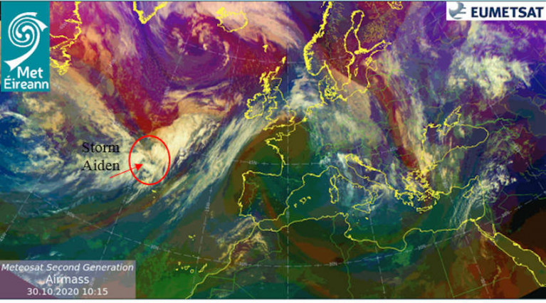
A Status Orange weather warning is in place for all Irish coastal waters and the Irish Sea as strong gales are set to develop overnight with the arrival of Storm Aiden, the first of the new storm season.
Met Éireann reports that winds will reach storm force off the South and South West Coasts in the early hours of tomorrow, Saturday 31 October, later veering westerly during the day and reaching gale to storm force on all coastal waters and the Irish Sea.
Tomorrow morning’s winds will reach mean speeds of 65 to 80km/h, with severe and damaging gusts of 100 to 130km/h, affecting Cork, Kerry, Waterford and Wexford as well as Carlow, Kilkenny and Wicklow.
#StormAiden has been named by Met Éireann for Halloween. Orange & yellow wind warnings are in effect for Sat. Potential for severe & damaging gusts.
— Met Éireann (@MetEireann) October 30, 2020
All current warnings here : https://t.co/ozrQHtGpc1
Satellite below shows the position of #StormAiden in the Atlantic pic.twitter.com/mblYdArK0B
Later in the day these severe winds will veer west over counties Clare, Galway, Mayo, Sligo and Donegal. The rest of Ireland is under Status Yellow with lesser but still potentially damaging gusts forecast, as well as a risk of coastal flooding.
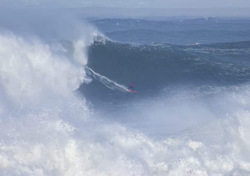 A surfer rides a large wave at Mullaghmore, Co Sligo on Wednesday | Noel Fitzpatrick/Met Éireann
The storm follows the remnants of Hurricane Epsilon, which brought ‘phenomenal’ class seas to the West Coast on Tuesday and Wednesday — just the ticket for the big wave surfing enthusiasts of Mullaghmore Head.
Local surfers told RTÉ News that the swells of earlier this week were some of the biggest they’ve ever seen here, and Conor Maguire was among those up for the challenge.
Dramatic surf conditions in the Atlantic Ocean caused by Hurricane Epsilon have created waves of over 18m off the coast of Sligo. Elite surfer Conor Maguire, who caught the waves today, said it was a rare and special experience. pic.twitter.com/qcXsOqTUs8
— RTÉ News (@rtenews) October 28, 2020
Met Éireann has issued a Status Red marine warning as Storm Ellen approaches today, Wednesday 19 August.
Gale- to storm-force winds, southeast veering southwest, are forecast for this evening and tonight on all Irish coastal waters and on the Irish Sea.
Winds will even reach violent storm Force 11 for a time on the South and West Coasts from Carnsore Point to Valentia to Slyne Head.
From tonight to early Friday the weather may result in unsafe conditions and disruption especially over high ground, lakes and sea areas.
There is also a risk of flooding from storm surges as heavy rains meet spring tides at their highest.
Cork will bear the brunt of the storm, which will produce a core of very severe and destructive winds between 9pm and midnight tonight.
Storm Jorge: Status Red Marine Warning For All Irish Coastal Waters
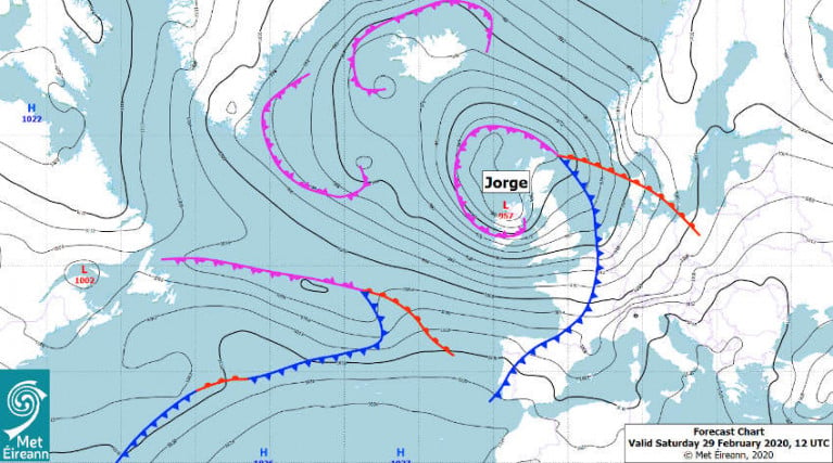
A Status Red marine weather warning is in place this morning (Saturday 29 February) as Storm Jorge brings southwesterly winds to gale or strong gale force on all Irish coastal waters.
Winds will veer westerly later this morning and this afternoon, increasing from gale force to storm force, and reaching violent storm force for a time between Loop Head and Erris Head.
On land, Met Éireann says the strongest winds will be experienced in Galway and Clare, reaching mean speeds of 85 to 100km/h in places this afternoon with gusts of 130 to 145km/h, and with an elevated rusk of coastal flooding.
“The combination of high seas and strong winds or stormy conditions associated with Storm Jorge may increase the possibility of coastal flooding, especially in flood-prone areas along the Atlantic coast on Saturday (particularly when coincident with high tides),” the meteorological service adds.
A Status Orange wind warning is in place for the rest of the country as severe winds, southwest quickly veering wet and later northwest, will reach mean speeds of 65 to 80km/h with gusts of 110 to 130km/h — possibly higher in very exposed areas — with an elevated coastal flood risk.
Heavy rainfall over this weekend is expected to compound flooding issues with water levels already elevated nationwide, particularly in the northern half and in the Midlands.
Among events schedules for this weekend that have been cancelled is the Lagan Head of the River rowing event, which may be rescheduled for later this year.
Status Yellow Marine Warning In Place After Storm Atiyah’s Passage

A Status Yellow gale warning remains in place for all Irish coastal waters after Storm Atiyah brought high winds across the country yesterday (Sunday 8 December).
Northwesterly gales were expected for a time on waters from Malin Head to Howth Head to Roches Point and on the Irish Sea after the first winter storm of the current season tracked eastwards across the island of Ireland.
In addition, southerly gales or strong gales are forecast to develop tonight on all coastal waters and on the Irish Sea, in the warning posted by Met Éireann in effect from 6am this morning (Monday 9 December).
Earlier yesterday, a Status Red wind warning — the most severe — was issued for Kerry with gusts expected to reach over 130km/h yesterday evening, as RTÉ News reports.
Turkey Shoot sailing was cancelled for Dublin Bay due to the rising winds, as was the scheduled dinghy Frostbites event.
Reports of severe weather damage and other incidents came from around the country, with ESB Networks dealing with numerous power outages, fallen trees and debris on roads and rail lines — and one motorist who left their car too long on the shoreline Co Donegal saw the vehicle swamped by the tide.
A car is swamped by the tide on Rossnowlagh beach in Co Donegal #StormAtiyah | https://t.co/BiSmcpArj2 pic.twitter.com/rXrLZvszgU
— RTÉ News (@rtenews) December 8, 2019

“The sea will come and take” Dublin and Cork by 2050 if nothing is done to deal with the consequences of climate change, Gerald Fleming will say in an RTÉ TV documentary tonight as The Irish Times reports.
The former weather presenter and head of forecasting at Met Éireann adds that the port towns of Drogheda, Galway, Limerick, Waterford and Wexford are also particularly vulnerable to rising sea levels, increasingly severe weather, more frequent storm surges and extreme flooding.
Fleming explores the direct effects climate change has already had on the likes of Greenland, while he and researcher Cara Augustenborg will present computer models that show the damage that could be caused to Ireland in the not too distant future.
Will Ireland Survive 2050?, part of RTÉ’s new On Climate season, screens tonight (Monday 11 November) at 9.35pm on RTÉ One. Fleming tells more about the programme at RTE.ie.


