Displaying items by tag: BBC
A new TV series as Gaeilge follows presenters Tessa Fleming and Irial Ó Ceallaigh as they embark on an epic adventure paddling their way along the North Coast.
Together with kayaking expert John Hubbocks, the novice kayakers brave the unpredictable Atlantic wind and waves, pushing themselves beyond their comfort zones to complete their challenge.
This four-part series Kayak-Ó-Thuaidh, made by Macha Media for BBC Gaeilge and RTÉ with support from Northern Ireland Screen’s Irish Language Broadcast Fund, showcases the stunning scenery of the northern Atlantic coastline, its rich history and the people who call it home.
Tessa and Irial face many challenges along the way and draw on their inner strength and physical stamina to navigate storms, tides and physical injuries, as they paddle from northwest Donegal to the northeast coast of Co Antrim.
In the first episode, on BBC iPlayer and BBC Two Northern Ireland on Monday 11 March at 10pm, the presenters undergo difficult training sessions in Co Down before starting their journey at Bunbeg harbour in Co Donegal. Their first challenge takes them to Gola Island and then to the Bloody Foreland in Gaoth Dobhair.
Episode two continues with a challenging paddle that takes them from Magheraroarty Beach to Tory Island and on to Sheephaven Bay, concluding at the iconic lighthouse on the edge of the Fanad peninsula.
Our adventurers tackle the Inishowen peninsula in episode three, setting off from Fort Dunree they make their way to Inishtrahull, Ireland’s most northerly island, and continue eastwards towards Lough Foyle and Magilligan.
In the final episode, Tessa and Irial embark on the last leg of their journey from Magilligan to Ballycastle, with one last push taking them to the spectacular wildlife haven of Rathlin Island.
Kayak Ó Thuaidh starts on Monday 11 March at 10pm on BBC iPlayer and BBC Two Northern Ireland. All four episodes will be available to watch for viewers in Northern Ireland on BBC iPlayer from this date.
Titanic Emergency as Ill Passenger Airlifted
#TITANIC - The Titanic memorial cruise was yesterday forced to turn back just 100 miles from the southwest coast of Ireland after a passenger fell ill, BBC News reports.
The Irish Coast Guard rescue helicopter at Shannon was dispached to the MS Balmoral to retrieve BBC cameraman Tim Rex, 56, who was struck by a non-life threatening heart condition, according to the Irish Independent.
Rex, who was covering the memorial sailing for the BBC, was treated by ship's doctors before being airlifted to hospital as a precaution.
The emergency happened just hours after the ship departed Cobh, the last port of call of the ill-fated Titanic before it sank in the North Atlantic on 14 April 1912.
A spokesperson for Titanic Memorial Cruises confirmed that despite the delay, the ship is still on schedule and is expected to arrive at the Titanic wreck site as planned on Saturday.
Catch the North Coast Sea Kayak Trail On TV This Sunday
#KAYAKING - Northern Ireland's new North Coast Sea Kayak Trail is set to feature on BBC TV this weekend, OutdoorNI reports.
Earlier this month, Ellie Harrison from BBC's Countryfile programme paddled the trail with local guide Robin Ruddock and also visited the Port Moon Bothy, an old cottage refurbished as a rest stop for kayakers on the trail.
"The North Coast Sea Kayak Trail will offer a completely unique way to explore the Causeway Coast and the converted bothy at Port Moon is fast becoming the most talked about and indeed most spectacular accommodation in Ireland,” said CanoeNI.
The new trail joins a host of coastal canoe routes launched this year by CanoeNI, as previously reported on Afloat.ie.
Catch the North Coast Sea Kayak Trail on Countryfile this Sunday 27 November at 6.25pm on BBC One Northern Ireland.
Mussel Dredgers Make a Fleeting Trawl of Dalkey Sound
Two mussel dredger-trawlers made a rare transit of Dalkey Sound, last Friday, writes Jehan Ashmore.
The sound which is located to the south of Dublin Bay is not used by commercial traffic but is frequented by pleasure-craft, local fishing boats from Dun Laoghaire. In addition to occasional traffic by the Irish Naval Service, Marine Institute research vessel RV Celtic Voyager, the GSI's RV Keary and foreign tall-ships.
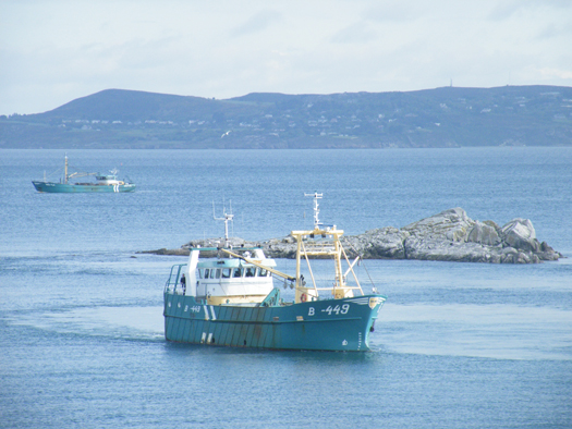
Dublin Bay. Photo Jehan Ashmore/ShipSNAPS
The vessels were making a southerly direction as they headed across Dublin Bay towards Dalkey Island. Mytilus lowered a mussel cage bucket into the sound which was dragged on two separate occasions over a short distance running parallel between the island and the coast.
The operation was all too brief as the Mytilus then proceeded into Killiney Bay followed closely astern by Branding. Upon entering the neighbouring bay, both vessels conducted dredging activity before continuing south beyond Bray Head.
Mussel grounds are located throughout certain hotspots in the Irish Sea and earlier this month, it is reported that there was a notable increase in mussel dredgers in Bangor, Northern Ireland. The dredgers were the Mytilus and Branding which berthed at the Co. Down harbour after a lengthy period of relative inactivity.
Mytilus was built in The Netherlands by Scheepwerf Van Os Yerseke B.V. and appeared in an episode of the successful BBC TV series 'Coast'. At the time of the broadcast she was registered at Beaumaris, Anglesey and was seen working in the northern approaches of the Menai Straits. The fishery grounds are ideally suited for the growing processes required in farmed mussel production.
Branding was also built by a Dutch shipyard, Kooieman in 1988 and her design is typical of the mussel dredgers based in Wexford. The market for mussels is mainly from the northern European countries of Belgium, France and the Netherlands.
- Dublin Bay
- Coast
- Marine Institute
- Northern Ireland
- naval service
- Dublin Bay News
- Anglesey
- Ports and Shipping News
- Island News
- RV Celtic Voyager
- TallShips
- RV Keary
- Geological Survey of Ireland
- GSI
- Mussel dredgers
- Mussel trawlers
- Mytilus
- Branding
- Dalkey Sound
- Fishery
- Menai Strait
- Beaumaris
- Banger
- Fish news
- BBC
- BBC TV series 'Coast'
- Belfastregistered
- Wexfordregistered
- Dutchbuilt
- Mussel markets
- Killiney Bay
- Bray Head


