Menu

Ireland's sailing, boating & maritime magazine

Dublin Bay Boating News and Information

Displaying items by tag: NPWS

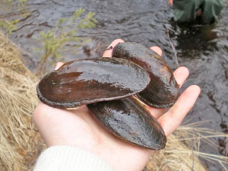
A new joint initiative between the Marine Institute and the National Parks and Wildlife Service (NPWS) aims to revitalise the freshwater pearl mussel through a pilot captive breeding programme.

Pearl mussels are capable of surviving for up to 140 years, making them Ireland’s longest living animal.

But environmental changed have put them on the verge of extinction. The species is listed as Endangered on the IUCN Red List, and is one of the 365 most endangered species in the world.

In Ireland, 19 Special Areas of Conservation (SACs) have been designated in an effort to conserve the pearl mussel in its native habitats.

‘We are hopeful that over time this joint project will lead to a positive outcome for the freshwater pearl mussel in Ireland’

And the new programme — to be based at the Marine Institute’s Newport Research Facility in Co Mayo, close to one of the last remaining reproducing populations of freshwater pearl mussels — is hoped to safeguard the survival of the rare species into the future.

“Captive breeding programmes are already well established in several countries, and we are hopeful that over time this joint project between the Marine Institute and the National Parks and Wildlife Service will lead to a positive outcome for the freshwater pearl mussel in Ireland,” said Dr Áine O'Connor of the NPWS.

One of the reasons for the decline of the freshwater pearl mussel is the low survival rate among juveniles, which are extremely sensitive to slight changes in environmental conditions. This is leading to an ageing population, not capable of replenishing itself.

Juvenile survival is dependent on a clean riverbed, with little silt, sediment or algal growth. These mussels also have a very unusual life cycle, in that they are dependent on the Atlantic salmon and brown trout to host their larvae, called glochidia, for about 10 months. The captive breeding programme is targeted at this crucial life stage.

‘This small experimental population will be given a year to see if the juveniles grow to the stage where they can settle themselves in a suitable habitat’

Work on the programme began this past June when a tank in the Marine Institute’s hatchery was set up with 300 juvenile salmon. In July, 30 adult mussels were removed from the Newport River and transported to the tank.

The project team are currently waiting to see if mussels will release glochidia and whether these will naturally attach themselves to the gills of the salmon.

If successful, the Marine Institute and NPWS will maintain this small experimental population for a year to see if the juveniles grow to the stage where the mussels can detach from the fish and settle themselves in a suitable habitat.

“Historically, we know the Burrishoole catchment [in the area around Newport] contained pearl mussels, which gives us some confidence that the water supply to the hatchery on Lough Feeagh is suitable for long-term maintenance of the mussel populations,” said Marine Institute zoologist Dr Elvira de Eyto.

The pilot captive breeding programme is a partnership between the Marine Institute and NPWS in conjunction with freshwater pearl mussel specialists Evelyn Moorkens and Ian Killeen.

Published in Marine Wildlife

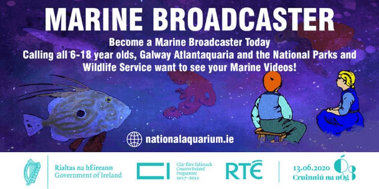
To celebrate Cruinniú na nÓg 2020 this Saturday 13 June, the National Parks and Wildlife Services and Galway Atlantaquaria are inviting 6-18 year olds to become marine broadcasters.

All you have to do is record a short video about a marine topic, such as an animal or plant from the seashore, and send to [email protected] before 5pm tomorrow, Friday 12 June. The first 50 entries will also receive a free beginner's guide to Ireland's seashore.

Videos should be no longer than two minutes and your videos will be uploaded onto a Marine Broadcaster playlist on the Galway Atlantaquaria YouTube channel, with a selection to be showcased as part of Cruinniú na nÓg this Saturday.

The channel also provides some inspiration to help you make your own broadcast. For more information on how to enter, see the Galway Atlantaquaria website HERE.

Published in Marine Science

#Flooding - Galway county councillors have blamed the National Parks and Wildlife Service for blocking flood prevention measures.

Galway Bay FM reports on a special sitting of Galway County Council, which heard a number of members take the NPWS to task over what they perceived as putting protections for wildlife over those of hundreds of families in the county affected by the recent severe flooding along the Shannon.

Cllr Michael Connolly claimed relief works planned for Meelick were halted over concerns with a single fish species – while Cllr Michael Fahy scoffed that digging emergency channels was more important than "bats and the bees".

Galway Bay FM has more on the story HERE.

Published in News Update
Tagged under

Dublin Bay

Dublin Bay on the east coast of Ireland stretches over seven kilometres, from Howth Head on its northern tip to Dalkey Island in the south. It's a place most Dubliners simply take for granted, and one of the capital's least visited places. But there's more going on out there than you'd imagine.

The biggest boating centre is at Dun Laoghaire Harbour on the Bay's south shore that is home to over 1,500 pleasure craft, four waterfront yacht clubs and Ireland's largest marina.

The bay is rather shallow with many sandbanks and rocky outcrops, and was notorious in the past for shipwrecks, especially when the wind was from the east. Until modern times, many ships and their passengers were lost along the treacherous coastline from Howth to Dun Laoghaire, less than a kilometre from shore.

The Bay is a C-shaped inlet of the Irish Sea and is about 10 kilometres wide along its north-south base, and 7 km in length to its apex at the centre of the city of Dublin; stretching from Howth Head in the north to Dalkey Point in the south. North Bull Island is situated in the northwest part of the bay, where one of two major inshore sandbanks lie, and features a 5 km long sandy beach, Dollymount Strand, fronting an internationally recognised wildfowl reserve. Many of the rivers of Dublin reach the Irish Sea at Dublin Bay: the River Liffey, with the River Dodder flow received less than 1 km inland, River Tolka, and various smaller rivers and streams.

Dublin Bay FAQs

There are approximately ten beaches and bathing spots around Dublin Bay: Dollymount Strand; Forty Foot Bathing Place; Half Moon bathing spot; Merrion Strand; Bull Wall; Sandycove Beach; Sandymount Strand; Seapoint; Shelley Banks; Sutton, Burrow Beach

There are slipways on the north side of Dublin Bay at Clontarf, Sutton and on the southside at Dun Laoghaire Harbour, and in Dalkey at Coliemore and Bulloch Harbours.

Dublin Bay is administered by a number of Government Departments, three local authorities and several statutory agencies. Dublin Port Company is in charge of navigation on the Bay.

Dublin Bay is approximately 70 sq kilometres or 7,000 hectares. The Bay is about 10 kilometres wide along its north-south base, and seven km in length east-west to its peak at the centre of the city of Dublin; stretching from Howth Head in the north to Dalkey Point in the south.

Dun Laoghaire Harbour on the southside of the Bay has an East and West Pier, each one kilometre long; this is one of the largest human-made harbours in the world. There also piers or walls at the entrance to the River Liffey at Dublin city known as the Great North and South Walls. Other harbours on the Bay include Bulloch Harbour and Coliemore Harbours both at Dalkey.

There are two marinas on Dublin Bay. Ireland's largest marina with over 800 berths is on the southern shore at Dun Laoghaire Harbour. The other is at Poolbeg Yacht and Boat Club on the River Liffey close to Dublin City.

Car and passenger Ferries operate from Dublin Port to the UK, Isle of Man and France. A passenger ferry operates from Dun Laoghaire Harbour to Howth as well as providing tourist voyages around the bay.

Dublin Bay has two Islands. Bull Island at Clontarf and Dalkey Island on the southern shore of the Bay.

The River Liffey flows through Dublin city and into the Bay. Its tributaries include the River Dodder, the River Poddle and the River Camac.

Dollymount, Burrow and Seapoint beaches

Approximately 1,500 boats from small dinghies to motorboats to ocean-going yachts. The vast majority, over 1,000, are moored at Dun Laoghaire Harbour which is Ireland's boating capital.

In 1981, UNESCO recognised the importance of Dublin Bay by designating North Bull Island as a Biosphere because of its rare and internationally important habitats and species of wildlife. To support sustainable development, UNESCO’s concept of a Biosphere has evolved to include not just areas of ecological value but also the areas around them and the communities that live and work within these areas. There have since been additional international and national designations, covering much of Dublin Bay, to ensure the protection of its water quality and biodiversity. To fulfil these broader management aims for the ecosystem, the Biosphere was expanded in 2015. The Biosphere now covers Dublin Bay, reflecting its significant environmental, economic, cultural and tourism importance, and extends to over 300km² to include the bay, the shore and nearby residential areas.

On the Southside at Dun Laoghaire, there is the National Yacht Club, Royal St. George Yacht Club, Royal Irish Yacht Club and Dun Laoghaire Motor Yacht Club as well as Dublin Bay Sailing Club. In the city centre, there is Poolbeg Yacht and Boat Club. On the Northside of Dublin, there is Clontarf Yacht and Boat Club and Sutton Dinghy Club. While not on Dublin Bay, Howth Yacht Club is the major north Dublin Sailing centre.

© Afloat 2020