Menu

Ireland's sailing, boating & maritime magazine

Dublin Bay Boating News and Information

Displaying items by tag: ALF Gannet

Dublin docklands property developer Harry Crosbie has been refused permission to relocate the former lightship Kittiwake in front of the O2 Theatre, according to a report in today's Irish Times.
Crosbie had intended to convert the 1959 built Kittiwake into a café and bar after raising the vessel from her River Liffey berth and position onto the campshire of North Quay Wall, opposite the music venue.

Dublin City Council told Crosbie that consent for the use of the campshires for the bar had not been agreed to by the board of the Dublin Dockland Development Authority (DDDA), which owns the quays, "and that said permission will not be forthcoming".

Crosbie had received a letter from the then chief executive officer of the DDDA Paul Maloney in December 2008 saying that the authority was willing to let the development go ahead, subject to consent from the authority's executive board.

This permission will not know be forthcoming but the authority does feel that the ship should be used as a bar on the Liffey itself rather than on the campshires.

The Kittiwake has laid idle since 2007 when the vessel was purchased from the Commissioners of Irish Lights. She was the second last lightship to serve in Irish waters. During the 1980's she and several other lightships were converted from manned operation into automatic light-floats or ALF's. To read more about the last Irish lightship ALF Gannet click HERE.

Published in Dublin Bay

The Commissioners of Irish Lights (CIL) withdrew the Codling Bank Lanby off Arklow on 24 July. This was the last Lanby to serve in Irish waters. The Lanby (Large Automated Navigation Buoy) is essentially a floating circular platform with a tower positioned centrally and fitted with a light to ward off potential dangers to shipping, writes Jehan Ashmore.

The Lanby was replaced with a Type 1 buoy which has a focal in excess of 5 metres and is fitted with a racon and Automatic Identification System (AIS).

Irish Lights aids to navigation tender, ILV Granuaile towed the former Codling Lanby to Dublin. The Lanby was hoisted out of the water and remains high and dry on the quayside awaiting demolition by the Hammond Lane Company. This final Lanby completes the withdrawal of Major Floating Aids to Navigation (MFAs) throughout Irish waters.

Lanbys were first introduced in the 1960s as replacements for lightships on certain stations. The ALF Gannet, the last Irish lightship, which was converted in the mid-1980's into an Automatic Light-Float (ALF) was withdrawn from the South Rock station off Portavogie in February 2009. The ALF Gannet was towed to Dun Laoghaire and laid-up at Carlisle Pier. Earlier this year ALF Gannet was sold and towed to new owners in the UK.

With modern navigating systems coupled with the amount of traffic and the degree of risk, CIL made the decision to withdraw the MFAs and replace them with Type 1 buoys.

The work of maintaining navigational aids is conducted at CIL's joint marine depot and head-quarters at Dun Laoghaire, which was built in 2008. A marine-depot facility did exist previously at the same site while administrative offices were located in Pembroke Street, Dublin.

In June, CIL celebrated its 200th year since establishment in 1810. The authority is entrusted to maintain, service and update all aids to navigation around the entire coastline of Ireland, providing a vital and invaluable service to mariners.

Assides the use of the tender, ILV Granuaile, Irish Lights also operate the tug-buoy tender, Puffin, also based at Dun Laoghaire.

Codling

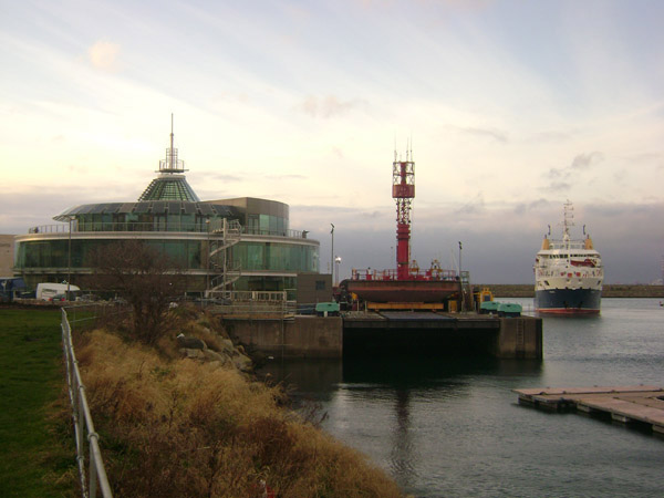
The Codling LANBY at  Irish Lights headquarters, Dun Laoghaire in 2009 with tender ILV Granuaile. Photo: Jehan Ashmore/ShipSNAPS

Published in Lighthouses

Dublin Bay

Dublin Bay on the east coast of Ireland stretches over seven kilometres, from Howth Head on its northern tip to Dalkey Island in the south. It's a place most Dubliners simply take for granted, and one of the capital's least visited places. But there's more going on out there than you'd imagine.

The biggest boating centre is at Dun Laoghaire Harbour on the Bay's south shore that is home to over 1,500 pleasure craft, four waterfront yacht clubs and Ireland's largest marina.

The bay is rather shallow with many sandbanks and rocky outcrops, and was notorious in the past for shipwrecks, especially when the wind was from the east. Until modern times, many ships and their passengers were lost along the treacherous coastline from Howth to Dun Laoghaire, less than a kilometre from shore.

The Bay is a C-shaped inlet of the Irish Sea and is about 10 kilometres wide along its north-south base, and 7 km in length to its apex at the centre of the city of Dublin; stretching from Howth Head in the north to Dalkey Point in the south. North Bull Island is situated in the northwest part of the bay, where one of two major inshore sandbanks lie, and features a 5 km long sandy beach, Dollymount Strand, fronting an internationally recognised wildfowl reserve. Many of the rivers of Dublin reach the Irish Sea at Dublin Bay: the River Liffey, with the River Dodder flow received less than 1 km inland, River Tolka, and various smaller rivers and streams.

Dublin Bay FAQs

There are approximately ten beaches and bathing spots around Dublin Bay: Dollymount Strand; Forty Foot Bathing Place; Half Moon bathing spot; Merrion Strand; Bull Wall; Sandycove Beach; Sandymount Strand; Seapoint; Shelley Banks; Sutton, Burrow Beach

There are slipways on the north side of Dublin Bay at Clontarf, Sutton and on the southside at Dun Laoghaire Harbour, and in Dalkey at Coliemore and Bulloch Harbours.

Dublin Bay is administered by a number of Government Departments, three local authorities and several statutory agencies. Dublin Port Company is in charge of navigation on the Bay.

Dublin Bay is approximately 70 sq kilometres or 7,000 hectares. The Bay is about 10 kilometres wide along its north-south base, and seven km in length east-west to its peak at the centre of the city of Dublin; stretching from Howth Head in the north to Dalkey Point in the south.

Dun Laoghaire Harbour on the southside of the Bay has an East and West Pier, each one kilometre long; this is one of the largest human-made harbours in the world. There also piers or walls at the entrance to the River Liffey at Dublin city known as the Great North and South Walls. Other harbours on the Bay include Bulloch Harbour and Coliemore Harbours both at Dalkey.

There are two marinas on Dublin Bay. Ireland's largest marina with over 800 berths is on the southern shore at Dun Laoghaire Harbour. The other is at Poolbeg Yacht and Boat Club on the River Liffey close to Dublin City.

Car and passenger Ferries operate from Dublin Port to the UK, Isle of Man and France. A passenger ferry operates from Dun Laoghaire Harbour to Howth as well as providing tourist voyages around the bay.

Dublin Bay has two Islands. Bull Island at Clontarf and Dalkey Island on the southern shore of the Bay.

The River Liffey flows through Dublin city and into the Bay. Its tributaries include the River Dodder, the River Poddle and the River Camac.

Dollymount, Burrow and Seapoint beaches

Approximately 1,500 boats from small dinghies to motorboats to ocean-going yachts. The vast majority, over 1,000, are moored at Dun Laoghaire Harbour which is Ireland's boating capital.

In 1981, UNESCO recognised the importance of Dublin Bay by designating North Bull Island as a Biosphere because of its rare and internationally important habitats and species of wildlife. To support sustainable development, UNESCO’s concept of a Biosphere has evolved to include not just areas of ecological value but also the areas around them and the communities that live and work within these areas. There have since been additional international and national designations, covering much of Dublin Bay, to ensure the protection of its water quality and biodiversity. To fulfil these broader management aims for the ecosystem, the Biosphere was expanded in 2015. The Biosphere now covers Dublin Bay, reflecting its significant environmental, economic, cultural and tourism importance, and extends to over 300km² to include the bay, the shore and nearby residential areas.

On the Southside at Dun Laoghaire, there is the National Yacht Club, Royal St. George Yacht Club, Royal Irish Yacht Club and Dun Laoghaire Motor Yacht Club as well as Dublin Bay Sailing Club. In the city centre, there is Poolbeg Yacht and Boat Club. On the Northside of Dublin, there is Clontarf Yacht and Boat Club and Sutton Dinghy Club. While not on Dublin Bay, Howth Yacht Club is the major north Dublin Sailing centre.

© Afloat 2020