Menu

Ireland's sailing, boating & maritime magazine

Dublin Bay Boating News and Information

Displaying items by tag: Abco Marine

#PortProject - A Northern Ireland based marine civil engineering firm, ABCO Marine have been contracted to work on a project located in Portsmouth.

The contract to the Lisburn firm is from Galliford Try for the construction of Fort Cumberland SST Sea Defences. The project involves replacing damaged sea defences next to the historical Fort Cumberland site in Eastney, Portsmouth.

Southern Water are taking the steps, to protect Fort Cumberland and three of their underground storm tanks, which are vital in helping to prevent flooding in the city of Portsmouth. The storm tanks and combined sewer outfall are an essential part of the catchment – and help to protect the city from sewer flooding during heavy rainfall.

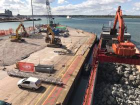
ABCO sourced and procured the rock for the project, with vessels chartered to transport the rock armour from Norway for offloading within Southampton Port where the rock is temporary stockpiled. The rock is then loaded onto cargo barges for marine tow and landing on Fort Cumberland beach, with the barges safely landed on a high tide operation. At low tide, the rock armour is unloaded and stockpiled on the beach in advance of the final rock revetment construction.

Last month ABCO began to mobilise the site which is programmed to be completed and handover in September 2017. Commenting on the contract, John Osborne, ABCO Marine Ltd Director, commented, "The Fort Cumberland Sea Defence project has taken months of planning and communications with both stakeholders and suppliers, all brought together to support the construction phase of the sea defence at Fort Cumberland.

Southampton Port and with special assistance by Langstone Harbour for pilotage have supported ABCO for the beach landing of the rock cargo barges. We are currently mobilising the final plant items to support the rock revetment construction phase, which we hope to have completed to programme. ABCO are delighted to be associated with Galliford Try and Southern Water to deliver the sea defence works".

Published in Ports & Shipping

#FORMER DUNDALK DREDGER – Hebble Sand (1963/757grt), a grab-hopper dredger which has remained in Dublin Port for more than one year departed Dublin Port and is currently heading for Campbeltown, on the Mull of Kintyre Peninsula, writes Jehan Ashmore.

As previously reported on Afloat.ie, the veteran vessel was purchased last October by Northern Ireland based Abco Marine Ltd. The marine-plant and engineering equipment company is headquartered in Lisburn. Prior to then the former Dundalk Port Company owned dredger had remained laid-up since her repositioning voyage from the Louth port in July of 2011.

The change of port, followed the transfer of the Dundalk Port Company assets, liabilities and operations to Dublin Port Company by an order of statutory instruments, which saw the capital port divest in the business of dredging.

Since then for the majority of her time spent in the port, she had moored in Alexandra Basin West, except for a short spell spent as reported at the nearby dry-dock facility after Abco brought the ship.

Yesterday she made the short passage across the basin to the river-berth alongside Ocean Pier in readiness for her first repositioning voyage under her new owners, in a career that has so far spanned just short of half a century.

This timeframe is pretty good going for a vessel, particularly engaged in the rough and tumble work of a humble dredger which remains in excellent condition. So her career continues and remarkably still retaining her original name since her launching from Richard (Shipbuilders) of Lowestoft who built her for British Dredging.

In this photo-link of the vessel in recent years, she is seen alongside Sir John Rogerson's Quay, Dublin Port, where she carried site preparatory work prior to the installation of the Samuel Beckett swing-bridge, which was towed on a barge from the Netherlands.

Note to the left of the small ship can be seen the gable-end of the last dockland warehouse sheds that were built on both sides of the campshires that line the Liffey, in an area now named the 'Docklands' quarter of the port.

With cargoships long gone, including the famous Guinness stout-tankers, the sheds historically represent the last such buildings in what was the 'real' docklands close to the inner-city.

One of the two-adjoining sheds (built in the 1880's) was occupied by BJ Marine and now the river-fronted 'Nama' property, formerly owned by the DDDA, have recently been placed on the market for sale or to let.

Published in Ports & Shipping

Dublin Bay

Dublin Bay on the east coast of Ireland stretches over seven kilometres, from Howth Head on its northern tip to Dalkey Island in the south. It's a place most Dubliners simply take for granted, and one of the capital's least visited places. But there's more going on out there than you'd imagine.

The biggest boating centre is at Dun Laoghaire Harbour on the Bay's south shore that is home to over 1,500 pleasure craft, four waterfront yacht clubs and Ireland's largest marina.

The bay is rather shallow with many sandbanks and rocky outcrops, and was notorious in the past for shipwrecks, especially when the wind was from the east. Until modern times, many ships and their passengers were lost along the treacherous coastline from Howth to Dun Laoghaire, less than a kilometre from shore.

The Bay is a C-shaped inlet of the Irish Sea and is about 10 kilometres wide along its north-south base, and 7 km in length to its apex at the centre of the city of Dublin; stretching from Howth Head in the north to Dalkey Point in the south. North Bull Island is situated in the northwest part of the bay, where one of two major inshore sandbanks lie, and features a 5 km long sandy beach, Dollymount Strand, fronting an internationally recognised wildfowl reserve. Many of the rivers of Dublin reach the Irish Sea at Dublin Bay: the River Liffey, with the River Dodder flow received less than 1 km inland, River Tolka, and various smaller rivers and streams.

Dublin Bay FAQs

There are approximately ten beaches and bathing spots around Dublin Bay: Dollymount Strand; Forty Foot Bathing Place; Half Moon bathing spot; Merrion Strand; Bull Wall; Sandycove Beach; Sandymount Strand; Seapoint; Shelley Banks; Sutton, Burrow Beach

There are slipways on the north side of Dublin Bay at Clontarf, Sutton and on the southside at Dun Laoghaire Harbour, and in Dalkey at Coliemore and Bulloch Harbours.

Dublin Bay is administered by a number of Government Departments, three local authorities and several statutory agencies. Dublin Port Company is in charge of navigation on the Bay.

Dublin Bay is approximately 70 sq kilometres or 7,000 hectares. The Bay is about 10 kilometres wide along its north-south base, and seven km in length east-west to its peak at the centre of the city of Dublin; stretching from Howth Head in the north to Dalkey Point in the south.

Dun Laoghaire Harbour on the southside of the Bay has an East and West Pier, each one kilometre long; this is one of the largest human-made harbours in the world. There also piers or walls at the entrance to the River Liffey at Dublin city known as the Great North and South Walls. Other harbours on the Bay include Bulloch Harbour and Coliemore Harbours both at Dalkey.

There are two marinas on Dublin Bay. Ireland's largest marina with over 800 berths is on the southern shore at Dun Laoghaire Harbour. The other is at Poolbeg Yacht and Boat Club on the River Liffey close to Dublin City.

Car and passenger Ferries operate from Dublin Port to the UK, Isle of Man and France. A passenger ferry operates from Dun Laoghaire Harbour to Howth as well as providing tourist voyages around the bay.

Dublin Bay has two Islands. Bull Island at Clontarf and Dalkey Island on the southern shore of the Bay.

The River Liffey flows through Dublin city and into the Bay. Its tributaries include the River Dodder, the River Poddle and the River Camac.

Dollymount, Burrow and Seapoint beaches

Approximately 1,500 boats from small dinghies to motorboats to ocean-going yachts. The vast majority, over 1,000, are moored at Dun Laoghaire Harbour which is Ireland's boating capital.

In 1981, UNESCO recognised the importance of Dublin Bay by designating North Bull Island as a Biosphere because of its rare and internationally important habitats and species of wildlife. To support sustainable development, UNESCO’s concept of a Biosphere has evolved to include not just areas of ecological value but also the areas around them and the communities that live and work within these areas. There have since been additional international and national designations, covering much of Dublin Bay, to ensure the protection of its water quality and biodiversity. To fulfil these broader management aims for the ecosystem, the Biosphere was expanded in 2015. The Biosphere now covers Dublin Bay, reflecting its significant environmental, economic, cultural and tourism importance, and extends to over 300km² to include the bay, the shore and nearby residential areas.

On the Southside at Dun Laoghaire, there is the National Yacht Club, Royal St. George Yacht Club, Royal Irish Yacht Club and Dun Laoghaire Motor Yacht Club as well as Dublin Bay Sailing Club. In the city centre, there is Poolbeg Yacht and Boat Club. On the Northside of Dublin, there is Clontarf Yacht and Boat Club and Sutton Dinghy Club. While not on Dublin Bay, Howth Yacht Club is the major north Dublin Sailing centre.

© Afloat 2020