Displaying items by tag: Algae
Waterways Ireland Issues Warning Over Blue-Green Algal Blooms
Waterways Ireland says it’s been notified of the presence of blue-green algae in a number of locations on the inland waterways.
Blue-green algae are toxic to humans and potentially lethal to animals.
The cross-border body for Ireland’s inland waterways asks boaters to comply with the notices placed by local authorities and avoid contact or immersive activities in areas where blue-green algae are present.
Waterways Ireland jetties and slipways remain open, but the agency advises boaters and other users to stay out of the water.
It also asks for the public to report any encounters with blue-green algal blooms to the relevant local authority.
Blue-Green Algae Threat Returns To Killarney Lake
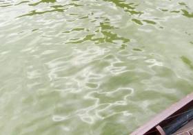
Kerry County Council is once again warning pet owners to be vigilant around Lough Leane in Killarney after the detection of blue-green algae, as RTÉ News reports.
Samples taken in recent days show the presence of the algae, which has the potential to form a scum that’s toxic to animals.
Last July pet owners were advised to be vigilant over the presence of Cyanobacteria which has turned the waterway a soupy pea-green colour.
A previous outbreak in 2016 was connected with a number of dog deaths.
RTÉ News has more on the story HERE.
Algal Bloom On East Coast Beaches Under Observation

#AlgalBloom - The Marine Institute says it is currently monitoring an algal bloom on beaches on the east coast of Ireland as a part of its Phytoplankton Monitoring programme.
The bloom was detected two weeks ago using satellite images and information provided by the Environmental Protection Agency (EPA) and Wexford County Council.
The Marine Institute has analysed a number of samples from the algal bloom and has identified the species as Phaeocystis pouchetii, a common species that has caused blooms along the east coast several times in previous years. The species causes discolouration of the water, and foaming on the beach in windy conditions.
Joe Silke of marine environment and food safety services at the Marine Institute emphasised that the species is not directly harmful to humans either through swimming or from consuming fish that have been exposed to the bloom.
Beaches remain safe despite any discolouration of water, though the production of foam, and in some extreme cases anoxia, can result in marine organism mortalities.
However, unlike last summer's destructive algal bloom on the west and north coasts that was responsible for significant fish and shellfish kills from Galway to Donegal, fish mortalities caused by this particular species in previous Irish blooms have not been observed, as wild fish tend to avoid the bloom. This may explain the low catches reported by sea anglers on the east coast in recent weeks.
Several fishermen have also reported clogging of nets in recent weeks, which may be caused by the decaying bloom sinking to the seafloor.
Algal blooms are commonly detected over the summer months in coastal areas. It is likely that this particular bloom will dissipate in in the next week or so and will be replaced with the normal succession of microalgae that form the bottom of the food chain in the sea.
Algal Bloom Killing Fish, Shellfish Off West Coast

#MARINE WILDLIFE - An algal bloom off the west coast of Ireland is responsible for significant fish and shellfish kills from Galway to Donegal, according to the Marine Institute.
As The Irish Times reports, as much as 80% of stocks have been affected on Donegal oyster farms, and the bloom is also impacting negatively on angling tourism in the west and northwest.
The algae responsible, karenia mikimotai, occurs naturally in Ireland's coastal waters during the summer months and his harmless to humans, but contains a "toxic irritant" that damages the gills of fish, shellfish and other marine species.
Low-level samples were first detected in May but in the last two weeks it has grown into a dense bloom from Donegal to Mayo, with high levels now being recorded in Galway Bay, according to the Marine Institute's Joe Silke.
"In Donegal the bloom was so dense that there were many reports of discoloured red or brown water in some areas and several areas have reported dead marine life washing up on the shoreline, requiring local authorities to close certain beaches,” he said.
"The bloom affects species that live on or near the sea bed so we are seeing flatfish, lugworms and some shellfish getting washed up on the beaches."
The image evokes memories of the notorious 'red tide' that killed wild fish and shellfish along the west coast in 2005.
Meanwhile, the Marine Insitute said there are "some indications" that the bloom may be moving back out to sea, as observed in the latest satellite images and modelling data.
"However, cell counts of samples analysed in the Marine Institute... show that the bloom is still of the same density in the Donegal and Sligo regions as it was last week."


