Menu

Ireland's sailing, boating & maritime magazine

Dublin Bay Boating News and Information

Displaying items by tag: Belturbet

Waterways Ireland advises masters of vessels and users on the Shannon-Erne Waterway that the pump-out facility at Belturbet in Co Cavan is temporarily out of order.

This is due to a loss of power associated with the construction of the new service block being undertaken by Cavan County Council.

It’s expected that the electrical connection will be re-established in early June, in accordance with the builder’s latest programme of works.

In the intervening period, alternative boat pump-out facilities are available on the waterways at Aghalane, Galloon and Knockninny.

Published in Inland Waterways

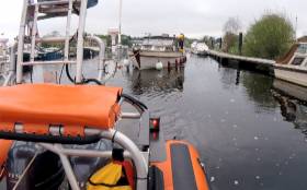
#RNLI - Carrybridge RNLI’s inshore lifeboat launched yesterday morning (Sunday 6 May) following a request by Belfast Coastguard to assist a 37ft cruiser taking on water on the lough near Belturbet, Co Cavan.

The lifeboat Douglas Euan & Kay Richards, with helm Chris Cathcart, David Reid, Kyle Boyd and Colin Beacom on board, launched at 7.28am from Upper Lough Erne in Co Fermanagh and arrived shortly after in Belturbet.

Winds were southerly, Force 1 and visibility was good with sunny skies.

The lifeboat crew located the casualty vessel moored alongside the public jetty, but still taking on water. Belturbet Fire and Rescue Service were also in attendance. The owner and his dog were unharmed.

The RNLI volunteer crew set up their salvage pump, and started to pump the water out of the casualty vessel. Once the water level started to lower, the access point of the water was located and a temporary seal put in place. 

The casualty vessel was then pumped out dry, and the lifeboat towed it to the public slipway where it was beached to avoid it sinking. The lifeboat departed the scene at 9.40am.

Following the callout, Cathcart said: “The crew were glad to be able to assist the owner this morning with his vessel, and hope he continues to have an enjoyable holiday.”

Much earlier on Sunday, the Portrush all-weather lifeboat crew in Co Antrim happened upon a casualty on land after a callout was stood down.

Three volunteer crew — Karl O’Neill, Jason Chambers and Ben Durrant — were returning home after the 1.40am call when they discovered a man who had fallen and had suffered significant injures to the face. 

The crew dialled 999 to request assistance. O’Neill, who is also an RNLI lifeguard supervisor, had his responder bag to hand and was able to administer first aid to stop the bleeding from the casualty’s face. Durrant then took the casualty to the local emergency department for further treatment.

Keith Gilmore Portrush RNLI lifeboat operations manager, commented: “Once again our volunteer crew have shown that the skills and training they have received as lifeboat crew members can be applied to assist in any situation. 

“I am very proud that the men on their way home at 2am stopped to help a member of the public who was obviously injured and in distress. We wish him a full recovery.”

Published in RNLI Lifeboats

Dublin Bay

Dublin Bay on the east coast of Ireland stretches over seven kilometres, from Howth Head on its northern tip to Dalkey Island in the south. It's a place most Dubliners simply take for granted, and one of the capital's least visited places. But there's more going on out there than you'd imagine.

The biggest boating centre is at Dun Laoghaire Harbour on the Bay's south shore that is home to over 1,500 pleasure craft, four waterfront yacht clubs and Ireland's largest marina.

The bay is rather shallow with many sandbanks and rocky outcrops, and was notorious in the past for shipwrecks, especially when the wind was from the east. Until modern times, many ships and their passengers were lost along the treacherous coastline from Howth to Dun Laoghaire, less than a kilometre from shore.

The Bay is a C-shaped inlet of the Irish Sea and is about 10 kilometres wide along its north-south base, and 7 km in length to its apex at the centre of the city of Dublin; stretching from Howth Head in the north to Dalkey Point in the south. North Bull Island is situated in the northwest part of the bay, where one of two major inshore sandbanks lie, and features a 5 km long sandy beach, Dollymount Strand, fronting an internationally recognised wildfowl reserve. Many of the rivers of Dublin reach the Irish Sea at Dublin Bay: the River Liffey, with the River Dodder flow received less than 1 km inland, River Tolka, and various smaller rivers and streams.

Dublin Bay FAQs

There are approximately ten beaches and bathing spots around Dublin Bay: Dollymount Strand; Forty Foot Bathing Place; Half Moon bathing spot; Merrion Strand; Bull Wall; Sandycove Beach; Sandymount Strand; Seapoint; Shelley Banks; Sutton, Burrow Beach

There are slipways on the north side of Dublin Bay at Clontarf, Sutton and on the southside at Dun Laoghaire Harbour, and in Dalkey at Coliemore and Bulloch Harbours.

Dublin Bay is administered by a number of Government Departments, three local authorities and several statutory agencies. Dublin Port Company is in charge of navigation on the Bay.

Dublin Bay is approximately 70 sq kilometres or 7,000 hectares. The Bay is about 10 kilometres wide along its north-south base, and seven km in length east-west to its peak at the centre of the city of Dublin; stretching from Howth Head in the north to Dalkey Point in the south.

Dun Laoghaire Harbour on the southside of the Bay has an East and West Pier, each one kilometre long; this is one of the largest human-made harbours in the world. There also piers or walls at the entrance to the River Liffey at Dublin city known as the Great North and South Walls. Other harbours on the Bay include Bulloch Harbour and Coliemore Harbours both at Dalkey.

There are two marinas on Dublin Bay. Ireland's largest marina with over 800 berths is on the southern shore at Dun Laoghaire Harbour. The other is at Poolbeg Yacht and Boat Club on the River Liffey close to Dublin City.

Car and passenger Ferries operate from Dublin Port to the UK, Isle of Man and France. A passenger ferry operates from Dun Laoghaire Harbour to Howth as well as providing tourist voyages around the bay.

Dublin Bay has two Islands. Bull Island at Clontarf and Dalkey Island on the southern shore of the Bay.

The River Liffey flows through Dublin city and into the Bay. Its tributaries include the River Dodder, the River Poddle and the River Camac.

Dollymount, Burrow and Seapoint beaches

Approximately 1,500 boats from small dinghies to motorboats to ocean-going yachts. The vast majority, over 1,000, are moored at Dun Laoghaire Harbour which is Ireland's boating capital.

In 1981, UNESCO recognised the importance of Dublin Bay by designating North Bull Island as a Biosphere because of its rare and internationally important habitats and species of wildlife. To support sustainable development, UNESCO’s concept of a Biosphere has evolved to include not just areas of ecological value but also the areas around them and the communities that live and work within these areas. There have since been additional international and national designations, covering much of Dublin Bay, to ensure the protection of its water quality and biodiversity. To fulfil these broader management aims for the ecosystem, the Biosphere was expanded in 2015. The Biosphere now covers Dublin Bay, reflecting its significant environmental, economic, cultural and tourism importance, and extends to over 300km² to include the bay, the shore and nearby residential areas.

On the Southside at Dun Laoghaire, there is the National Yacht Club, Royal St. George Yacht Club, Royal Irish Yacht Club and Dun Laoghaire Motor Yacht Club as well as Dublin Bay Sailing Club. In the city centre, there is Poolbeg Yacht and Boat Club. On the Northside of Dublin, there is Clontarf Yacht and Boat Club and Sutton Dinghy Club. While not on Dublin Bay, Howth Yacht Club is the major north Dublin Sailing centre.

© Afloat 2020