Menu

Ireland's sailing, boating & maritime magazine

Dublin Bay Boating News and Information

Displaying items by tag: Bulker Sumburgh Head

As the ro-ro ferry Norcape departed Dublin Port last Monday, on a routine sailing to Liverpool, the vessel passed the docked general dry-cargo bulker Wilson Tana. The vessels were involved in a collision in Dublin Bay, over 20 years ago, writes Jehan Ashmore.

On 18 February 1988 the vessels collided about a mile off the entrance to Dublin Port. The Norcape, was then under different ownership as B+I Line's 6,310grt Tipperary and the 4,694grt Wilson Tana, then named Sumburgh Head was owned by Norwegian shipping company Christian Salvesen.

Several small craft dashed to the scene as part of the rescue effort, fortunately the incident occurred close to the port and without loss of life or injury.

The bow of the Tipperary ruptured one of the Sumburgh Head holds, causing a large gash in hold No. 3 that led to over 3,500 tons of fertiliser spilling into the sea. The vessel was carrying in total 5,000 tonnes of the cargo from Rostock, then in the former East Germany.

Norcape

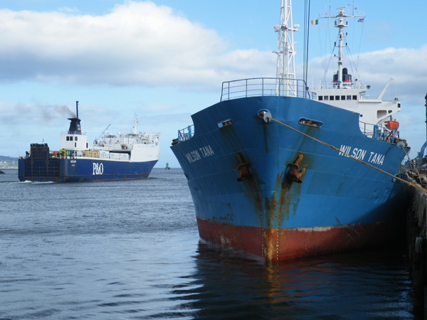
 Norcape (formerly B+I Line's Tipperary) and Wilson Tana (formerly Sumburgh Head) in Dublin Port on Monday. Photo J. Ashmore /ShipSNAPS

Also arriving at the scene were tugs to assist the disabled vessels. The Sumburgh Head was in need of more urgent attention having sustained heavy structural damage amidships to one of four cargo holds. Several attempts were made to pull Sumburgh Head free while the Tipperary used her bow thrusters and main engines in an attempt to pull away too.

After an hour the vessels parted, though air-sea rescue services were called as it was feared the Sumburgh Head was in a vulnerable situation. The vessel only developed a 10-degree list and limped into the port under towage. Tipperary was less damaged and managed to return to port under her own power.

Sumburgh Head received remedial attention with metal girders positioned across the gapping damaged hold. In comparison the Tipperary was less damaged except for a gash to the bow and several buckled bulbous bow plates. The ferry received repairs in the local dry-dock facility in Alexandra Basin.

The Sumburgh Head was built in 1977 at the Hashihama Zosen shipyard, Imabari in Japan. Incidentally, Tipperary was also built in Japan by Mitsui Engineering Shipbuilding, Tamano and launched in 1979. The newbuild was chartered to B+I Line to serve on a new Dublin-Fleetwood route jointly operated with P&O, using Tipperary's sister, Ibex.

In 1988, the route's UK port switched to Liverpool with Tipperary remaining on the route until sold to North Sea Ferries in 1989 and renamed Norcape. It is only this year that the vessel returned to Dublin-Liverpool for P&O (Irish Sea) completing a career circle.

As for Wilson Tana, the Maltese flagged bulker docked in Dublin after arriving from Gijon, northern Spain. For the next two days the vessels cargo of sand was unloaded at the Coal Quay before departing last night. 

Published in Dublin Bay

Dublin Bay

Dublin Bay on the east coast of Ireland stretches over seven kilometres, from Howth Head on its northern tip to Dalkey Island in the south. It's a place most Dubliners simply take for granted, and one of the capital's least visited places. But there's more going on out there than you'd imagine.

The biggest boating centre is at Dun Laoghaire Harbour on the Bay's south shore that is home to over 1,500 pleasure craft, four waterfront yacht clubs and Ireland's largest marina.

The bay is rather shallow with many sandbanks and rocky outcrops, and was notorious in the past for shipwrecks, especially when the wind was from the east. Until modern times, many ships and their passengers were lost along the treacherous coastline from Howth to Dun Laoghaire, less than a kilometre from shore.

The Bay is a C-shaped inlet of the Irish Sea and is about 10 kilometres wide along its north-south base, and 7 km in length to its apex at the centre of the city of Dublin; stretching from Howth Head in the north to Dalkey Point in the south. North Bull Island is situated in the northwest part of the bay, where one of two major inshore sandbanks lie, and features a 5 km long sandy beach, Dollymount Strand, fronting an internationally recognised wildfowl reserve. Many of the rivers of Dublin reach the Irish Sea at Dublin Bay: the River Liffey, with the River Dodder flow received less than 1 km inland, River Tolka, and various smaller rivers and streams.

Dublin Bay FAQs

There are approximately ten beaches and bathing spots around Dublin Bay: Dollymount Strand; Forty Foot Bathing Place; Half Moon bathing spot; Merrion Strand; Bull Wall; Sandycove Beach; Sandymount Strand; Seapoint; Shelley Banks; Sutton, Burrow Beach

There are slipways on the north side of Dublin Bay at Clontarf, Sutton and on the southside at Dun Laoghaire Harbour, and in Dalkey at Coliemore and Bulloch Harbours.

Dublin Bay is administered by a number of Government Departments, three local authorities and several statutory agencies. Dublin Port Company is in charge of navigation on the Bay.

Dublin Bay is approximately 70 sq kilometres or 7,000 hectares. The Bay is about 10 kilometres wide along its north-south base, and seven km in length east-west to its peak at the centre of the city of Dublin; stretching from Howth Head in the north to Dalkey Point in the south.

Dun Laoghaire Harbour on the southside of the Bay has an East and West Pier, each one kilometre long; this is one of the largest human-made harbours in the world. There also piers or walls at the entrance to the River Liffey at Dublin city known as the Great North and South Walls. Other harbours on the Bay include Bulloch Harbour and Coliemore Harbours both at Dalkey.

There are two marinas on Dublin Bay. Ireland's largest marina with over 800 berths is on the southern shore at Dun Laoghaire Harbour. The other is at Poolbeg Yacht and Boat Club on the River Liffey close to Dublin City.

Car and passenger Ferries operate from Dublin Port to the UK, Isle of Man and France. A passenger ferry operates from Dun Laoghaire Harbour to Howth as well as providing tourist voyages around the bay.

Dublin Bay has two Islands. Bull Island at Clontarf and Dalkey Island on the southern shore of the Bay.

The River Liffey flows through Dublin city and into the Bay. Its tributaries include the River Dodder, the River Poddle and the River Camac.

Dollymount, Burrow and Seapoint beaches

Approximately 1,500 boats from small dinghies to motorboats to ocean-going yachts. The vast majority, over 1,000, are moored at Dun Laoghaire Harbour which is Ireland's boating capital.

In 1981, UNESCO recognised the importance of Dublin Bay by designating North Bull Island as a Biosphere because of its rare and internationally important habitats and species of wildlife. To support sustainable development, UNESCO’s concept of a Biosphere has evolved to include not just areas of ecological value but also the areas around them and the communities that live and work within these areas. There have since been additional international and national designations, covering much of Dublin Bay, to ensure the protection of its water quality and biodiversity. To fulfil these broader management aims for the ecosystem, the Biosphere was expanded in 2015. The Biosphere now covers Dublin Bay, reflecting its significant environmental, economic, cultural and tourism importance, and extends to over 300km² to include the bay, the shore and nearby residential areas.

On the Southside at Dun Laoghaire, there is the National Yacht Club, Royal St. George Yacht Club, Royal Irish Yacht Club and Dun Laoghaire Motor Yacht Club as well as Dublin Bay Sailing Club. In the city centre, there is Poolbeg Yacht and Boat Club. On the Northside of Dublin, there is Clontarf Yacht and Boat Club and Sutton Dinghy Club. While not on Dublin Bay, Howth Yacht Club is the major north Dublin Sailing centre.

© Afloat 2020