Displaying items by tag: Cable
Galway Seabed Survey for Submarine Fibre Cable Between Iceland & Ireland
Iceland has selected Galway as the European landing location for international telecommunications cables.
Farice, a company fully owned by the Icelandic Government, currently owns and operates two submarine cables linking Iceland to Northern Europe.
It has been undertaking preparatory work for a new submarine fibre cable from Iceland to Europe since early 2019.
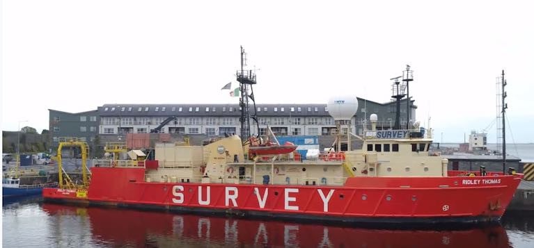
A survey ship named Ridley is now exploring suitable seabed approaches from Galway out to the boundary of the Irish exclusive economic zone (EEZ).
 The 58-metre Ridley Thomas (IMO: 8112744) is a Research/Survey Vessel built in 1981
Farice chief executive officer Thorvardur Sveinsson said that “after careful consideration of many factors, Galway was selected by Farice as the European cable landing location”.
“The Icelandic landing site will be on the Reykjanes peninsula with the final location to be decided during the winter 2020/2021,” he said.
“ This coupled with Galway’s reputation for business, education and hospitality will lead to a win-win situation. The enhanced global activity provided by the system will be a catalyst for attracting high tech business to the city and the regions,” he said.
The company said the project could result in a new submarine fibre cable between Iceland and Ireland becoming operational within two years from financing being secured.
“Ireland has many important attributes that make it attractive as a destination for this new cable from Iceland, over and above the relatively short distance between the two countries,” Mr Sveinsson explained.
 Ireland is at the nexus of new trans-Atlantic connections - A map showing the new cable route between Iceland and Ireland that could be operational within two years
“Ireland is at the nexus of new trans-Atlantic connections, is a centre of choice for European operations for many international businesses and has a rich and diverse pool of skilled labour in its workforce. Ireland has thus firmly established itself at the forefront of the development of Europe’s digital infrastructure and as such is an important connection point for a new submarine cable between Iceland and Europe,” he said.
“It is often perceived that international telecommunications are carried out by satellite. This is a common misconception and in reality, the vast majority of global communications is carried on fibre optic cables and particularly sub-sea cables,” he explained.
“The capacity of such cables is quite incredible and a single pair of fibre strands could satisfy the demands of most of Galway city,” he said.
“Due to the very high capacity of modern systems, subsea fibre cables are incredibly small in size (approx. 25mm diameter) and are very fast and non-intrusive to install. The overall benefits greatly outweigh the short-term inconvenience during the installation,” he said.
“The presence of the Farice system landing in Galway will provide direct high capacity links to Iceland but also to Northern Europe via Denmark and the UK and will greatly increase capacity and connectivity in Galway city and the regions,” he added.
The company currently operates the FARICE-1 cable between Iceland and Scotland with a branch connection to the Faroe Islands and the DANICE submarine cable between Iceland and Denmark.
A third submarine cable Greenland-Connect links Iceland to Canada and US. The Icelandic government said the fourth cable would “increase further the security and resiliency of Iceland’s international telecommunications.”
The new cable could cost up to €2 million during the research phase, with the actual laying estimated last year at around 32 million US dollars.
#Subsea - The Irish Times has more details on the new transatlantic subsea internet cable Hibernia Express, work on which got underway this past March.
Clearance and pre-laying work continued this month in the Celtic Sea to prepare for the arrival of the 4,600km fibre optic cable in Cork Harbour in the coming weeks.
Once connected to the new Cork Internet Exchange (CIX), it will be the first modern telecommunications cable of its kind to link North America and Europe in well over a decade.
And its speed and capacity – offering the lowest latency between New York and London – will be a boon for businesses that depend on the fastest possible and most robust data connections.
Combined with the shorter Ireland-France Subsea Cable, it's also set to make Cork a leading global internet switching centre, eliminating the need for Ireland's internet traffic to go through the UK before the rest of the world, as TechCentral reports.
#HiberniaExpress - The Department of Transport, Tourism and Sport advises that TE SubCom, on behalf of Hibernia Express, is carrying out a route clearance operation and a pre-lay grapnel run along the Hibernia Express cable route using the M/V Ile d’Aix (Callsign FICI) and M/V Atlantic Guardian (Callsign HO6566.
The operations, which follow earlier work on the same subsea cable route in March, commenced on 17 and 13 May 2015 respectively are expected to last until the end of June 2015, weather permitting.
The vessels will be towing grapnels astern at a distance depending on water depth, and as such, will be restricted in their ability to manoeuvre.
All vessels are requested to give these operation a wide berth. The project vessels will be listening on VHF Channel 16 throughout the project.
Details of co-ordinates for both vessels' work areas are included in Marine Notices Nos 18 and 19 of 2015, available to read or download HERE and HERE.


