Menu

Ireland's sailing, boating & maritime magazine

Dublin Bay Boating News and Information

Displaying items by tag: Carp Edema Virus

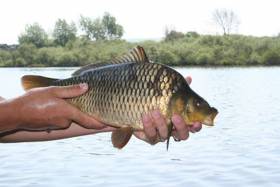
#Angling - Scientists at the Marine Institute’s Fish Health Unit are conducting further testing on sample carp from The Lough and Belvelly in Cork after the recent outbreak of suspected carp edema virus.

The tests include sequencing of the viral DNA to confirm its identity, and until confirmed the current findings shall be regarded as preliminary, according to a statement from the Marine Institute.

Molecular tests for Koi Herpesvirus Disease (KHV), a listed disease under European Fish Health legislation, were negative for all fish sampled. Additional molecular tests for cyprinid herpesvirus (other than KHV) were also in progress as of yesterday, Thursday 17 May.

The gills and skin of the sampled fish revealed an extremely high infestation of trichodinid parasites along with a fungal infection. White spots on the scales were also microscopically examined but there was no evidence of Ichthyophthirius multifilius infection.

Virological screening for Spring Viraemia of Carp is still ongoing with no virus observed to date. Bacteriological tests have revealed no growth of bacteria.

“While we’ve identified the presence of CEV — known to cause koi sleepy disease — in all the samples tested to date at the Marine Institute, we are still carrying out further tests for confirmation of the cause of the carp mortalities at The Lough and Belvelly lake,” said Dr Neil Ruane from the Fish Health Unit.

Dr Jeff Fisher, director of marine environment and food safety service at the Marine Institute, added: “Though the ultimate cause of the introduction of the disease agent into the loughs cannot be determined from current information, the loss of significant numbers of carp in these two lakes highlights the need for vigilance among anglers and other recreational users of Irish waters in the cleaning of their equipment and gear thoroughly after use, and also for the need for fishery owners and members of the public to be aware of the potential risk of transferring fish that may carry disease into the wild, and to never release ornamental fish into lakes or rivers.

“We’re continuing to work closely with Inland Fisheries Ireland and Cork City Council, and the Cork Carp Anglers Club to determine the cause of this fish kill, contain the incident, and identify appropriate biosecurity measures for the future.”

More than 750 carp were lost in the outbreak at The Lough in Cork city centre earlier this month, with the Cork Carp Anglers Club estimating the cost of replacing even a fraction of this number at €200,000 or more.

Published in Angling

Dublin Bay

Dublin Bay on the east coast of Ireland stretches over seven kilometres, from Howth Head on its northern tip to Dalkey Island in the south. It's a place most Dubliners simply take for granted, and one of the capital's least visited places. But there's more going on out there than you'd imagine.

The biggest boating centre is at Dun Laoghaire Harbour on the Bay's south shore that is home to over 1,500 pleasure craft, four waterfront yacht clubs and Ireland's largest marina.

The bay is rather shallow with many sandbanks and rocky outcrops, and was notorious in the past for shipwrecks, especially when the wind was from the east. Until modern times, many ships and their passengers were lost along the treacherous coastline from Howth to Dun Laoghaire, less than a kilometre from shore.

The Bay is a C-shaped inlet of the Irish Sea and is about 10 kilometres wide along its north-south base, and 7 km in length to its apex at the centre of the city of Dublin; stretching from Howth Head in the north to Dalkey Point in the south. North Bull Island is situated in the northwest part of the bay, where one of two major inshore sandbanks lie, and features a 5 km long sandy beach, Dollymount Strand, fronting an internationally recognised wildfowl reserve. Many of the rivers of Dublin reach the Irish Sea at Dublin Bay: the River Liffey, with the River Dodder flow received less than 1 km inland, River Tolka, and various smaller rivers and streams.

Dublin Bay FAQs

There are approximately ten beaches and bathing spots around Dublin Bay: Dollymount Strand; Forty Foot Bathing Place; Half Moon bathing spot; Merrion Strand; Bull Wall; Sandycove Beach; Sandymount Strand; Seapoint; Shelley Banks; Sutton, Burrow Beach

There are slipways on the north side of Dublin Bay at Clontarf, Sutton and on the southside at Dun Laoghaire Harbour, and in Dalkey at Coliemore and Bulloch Harbours.

Dublin Bay is administered by a number of Government Departments, three local authorities and several statutory agencies. Dublin Port Company is in charge of navigation on the Bay.

Dublin Bay is approximately 70 sq kilometres or 7,000 hectares. The Bay is about 10 kilometres wide along its north-south base, and seven km in length east-west to its peak at the centre of the city of Dublin; stretching from Howth Head in the north to Dalkey Point in the south.

Dun Laoghaire Harbour on the southside of the Bay has an East and West Pier, each one kilometre long; this is one of the largest human-made harbours in the world. There also piers or walls at the entrance to the River Liffey at Dublin city known as the Great North and South Walls. Other harbours on the Bay include Bulloch Harbour and Coliemore Harbours both at Dalkey.

There are two marinas on Dublin Bay. Ireland's largest marina with over 800 berths is on the southern shore at Dun Laoghaire Harbour. The other is at Poolbeg Yacht and Boat Club on the River Liffey close to Dublin City.

Car and passenger Ferries operate from Dublin Port to the UK, Isle of Man and France. A passenger ferry operates from Dun Laoghaire Harbour to Howth as well as providing tourist voyages around the bay.

Dublin Bay has two Islands. Bull Island at Clontarf and Dalkey Island on the southern shore of the Bay.

The River Liffey flows through Dublin city and into the Bay. Its tributaries include the River Dodder, the River Poddle and the River Camac.

Dollymount, Burrow and Seapoint beaches

Approximately 1,500 boats from small dinghies to motorboats to ocean-going yachts. The vast majority, over 1,000, are moored at Dun Laoghaire Harbour which is Ireland's boating capital.

In 1981, UNESCO recognised the importance of Dublin Bay by designating North Bull Island as a Biosphere because of its rare and internationally important habitats and species of wildlife. To support sustainable development, UNESCO’s concept of a Biosphere has evolved to include not just areas of ecological value but also the areas around them and the communities that live and work within these areas. There have since been additional international and national designations, covering much of Dublin Bay, to ensure the protection of its water quality and biodiversity. To fulfil these broader management aims for the ecosystem, the Biosphere was expanded in 2015. The Biosphere now covers Dublin Bay, reflecting its significant environmental, economic, cultural and tourism importance, and extends to over 300km² to include the bay, the shore and nearby residential areas.

On the Southside at Dun Laoghaire, there is the National Yacht Club, Royal St. George Yacht Club, Royal Irish Yacht Club and Dun Laoghaire Motor Yacht Club as well as Dublin Bay Sailing Club. In the city centre, there is Poolbeg Yacht and Boat Club. On the Northside of Dublin, there is Clontarf Yacht and Boat Club and Sutton Dinghy Club. While not on Dublin Bay, Howth Yacht Club is the major north Dublin Sailing centre.

© Afloat 2020