Menu

Ireland's sailing, boating & maritime magazine

Dublin Bay Boating News and Information

Displaying items by tag: Christopher Columbus

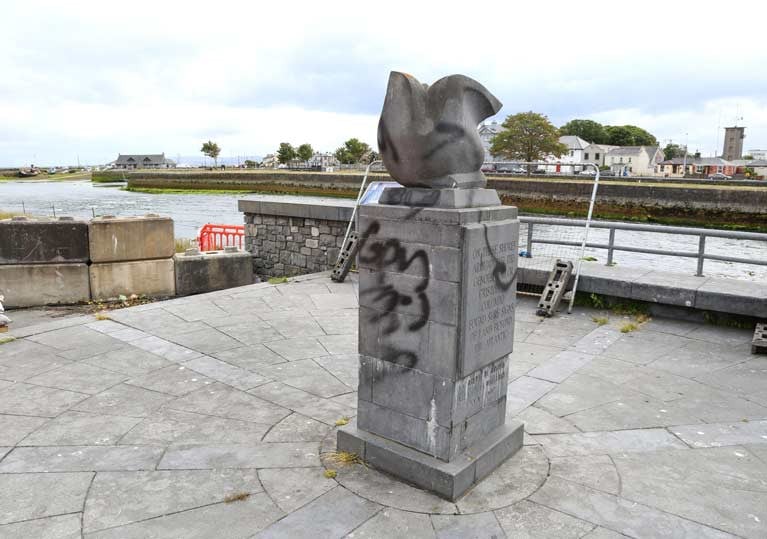
A former Italian honorary consul has expressed disappointment at damage to a monument marking explorer Christopher Columbus’s links to Galway.

A Labour city councillor, Niall MacNelis, has also condemned the spraying of black paint on the monument, and says he has reported the matter to the Garda Siochána.

Adriano Cavalleri was honorary consul to Galway when the monument was unveiled in 1992 to mark the 500th anniversary of Columbus’s voyage to the Americas.

Mr Cavalleri explained it was intended to celebrate the navigation skills of Columbus and his crew, and the fact that he is believed to have docked in Galway port in 1477.

Late Italian historian and Columbus biographer Paolo Emilio Taviani had established that Columbus had called to the port and received chart information, Mr Cavalleri said.

“We wished to celebrate these maritime skills, and the link between Galway and Genoa where Columbus was from,” Mr Cavalleri said.

The Columbus monument was donated by the city of Genoa, and its installation close to the Spanish Arch was supported by the Italian Cultural Institute.

Earlier this week, People Before Profit called on Galway City Council to remove monuments which “glorified slavery and racism”, including the Columbus monument.

It also criticised a plaque in Tuam honouring Major Richard (Dick) Dowling who served with the Confederate Army in the US.

Cllr MacNelis said that conflating Columbus’s visit to Galway in 1477 with slavery did “no service to the Black Lives Matter campaign”.

“If this is the approach, where do we stop – does this mean we don’t remember the Galway soldiers who lost their lives while fighting abroad,” Cllr MacNelis said.

Published in Galway Harbour

#SantaMaria - Christopher Columbus' voyage of discovery to the Americas more than 500 years ago is almost the stuff of legend today - but now marine archaeologists think they've found the remnants of his flagship, the Santa Maria.

The potential find off the north coast of Haiti - on what was then known as the island of Hispaniola - could give us a tangible connection to the stories we all learned at school about the Nina, Pinta and Santa Maria.

As The Independent reports, top archaeological investigator Barry Clifford says "all the geographical, underwater topography and archaeological evidence strongly suggests that this wreck is Columbus’ famous flagship."

And it's only happened because of a fresh look at images of the wreck taken more than 10 years ago, in the context of new dives to the site earlier this month.

Sadly the return dives saw various artefacts were missing, presumed raided by looters.

But it's hoped that the ship itself, if it is indeed confirmed as the one Columbus sailed to the New World in 1492, might be preserved in such a state that it could be raised and become an important tourist attraction for impoverished Haiti.

The Independent has much more on the story HERE.

Published in Historic Boats

Dublin Bay

Dublin Bay on the east coast of Ireland stretches over seven kilometres, from Howth Head on its northern tip to Dalkey Island in the south. It's a place most Dubliners simply take for granted, and one of the capital's least visited places. But there's more going on out there than you'd imagine.

The biggest boating centre is at Dun Laoghaire Harbour on the Bay's south shore that is home to over 1,500 pleasure craft, four waterfront yacht clubs and Ireland's largest marina.

The bay is rather shallow with many sandbanks and rocky outcrops, and was notorious in the past for shipwrecks, especially when the wind was from the east. Until modern times, many ships and their passengers were lost along the treacherous coastline from Howth to Dun Laoghaire, less than a kilometre from shore.

The Bay is a C-shaped inlet of the Irish Sea and is about 10 kilometres wide along its north-south base, and 7 km in length to its apex at the centre of the city of Dublin; stretching from Howth Head in the north to Dalkey Point in the south. North Bull Island is situated in the northwest part of the bay, where one of two major inshore sandbanks lie, and features a 5 km long sandy beach, Dollymount Strand, fronting an internationally recognised wildfowl reserve. Many of the rivers of Dublin reach the Irish Sea at Dublin Bay: the River Liffey, with the River Dodder flow received less than 1 km inland, River Tolka, and various smaller rivers and streams.

Dublin Bay FAQs

There are approximately ten beaches and bathing spots around Dublin Bay: Dollymount Strand; Forty Foot Bathing Place; Half Moon bathing spot; Merrion Strand; Bull Wall; Sandycove Beach; Sandymount Strand; Seapoint; Shelley Banks; Sutton, Burrow Beach

There are slipways on the north side of Dublin Bay at Clontarf, Sutton and on the southside at Dun Laoghaire Harbour, and in Dalkey at Coliemore and Bulloch Harbours.

Dublin Bay is administered by a number of Government Departments, three local authorities and several statutory agencies. Dublin Port Company is in charge of navigation on the Bay.

Dublin Bay is approximately 70 sq kilometres or 7,000 hectares. The Bay is about 10 kilometres wide along its north-south base, and seven km in length east-west to its peak at the centre of the city of Dublin; stretching from Howth Head in the north to Dalkey Point in the south.

Dun Laoghaire Harbour on the southside of the Bay has an East and West Pier, each one kilometre long; this is one of the largest human-made harbours in the world. There also piers or walls at the entrance to the River Liffey at Dublin city known as the Great North and South Walls. Other harbours on the Bay include Bulloch Harbour and Coliemore Harbours both at Dalkey.

There are two marinas on Dublin Bay. Ireland's largest marina with over 800 berths is on the southern shore at Dun Laoghaire Harbour. The other is at Poolbeg Yacht and Boat Club on the River Liffey close to Dublin City.

Car and passenger Ferries operate from Dublin Port to the UK, Isle of Man and France. A passenger ferry operates from Dun Laoghaire Harbour to Howth as well as providing tourist voyages around the bay.

Dublin Bay has two Islands. Bull Island at Clontarf and Dalkey Island on the southern shore of the Bay.

The River Liffey flows through Dublin city and into the Bay. Its tributaries include the River Dodder, the River Poddle and the River Camac.

Dollymount, Burrow and Seapoint beaches

Approximately 1,500 boats from small dinghies to motorboats to ocean-going yachts. The vast majority, over 1,000, are moored at Dun Laoghaire Harbour which is Ireland's boating capital.

In 1981, UNESCO recognised the importance of Dublin Bay by designating North Bull Island as a Biosphere because of its rare and internationally important habitats and species of wildlife. To support sustainable development, UNESCO’s concept of a Biosphere has evolved to include not just areas of ecological value but also the areas around them and the communities that live and work within these areas. There have since been additional international and national designations, covering much of Dublin Bay, to ensure the protection of its water quality and biodiversity. To fulfil these broader management aims for the ecosystem, the Biosphere was expanded in 2015. The Biosphere now covers Dublin Bay, reflecting its significant environmental, economic, cultural and tourism importance, and extends to over 300km² to include the bay, the shore and nearby residential areas.

On the Southside at Dun Laoghaire, there is the National Yacht Club, Royal St. George Yacht Club, Royal Irish Yacht Club and Dun Laoghaire Motor Yacht Club as well as Dublin Bay Sailing Club. In the city centre, there is Poolbeg Yacht and Boat Club. On the Northside of Dublin, there is Clontarf Yacht and Boat Club and Sutton Dinghy Club. While not on Dublin Bay, Howth Yacht Club is the major north Dublin Sailing centre.

© Afloat 2020