Menu

Ireland's sailing, boating & maritime magazine

Dublin Bay Boating News and Information

Displaying items by tag: Cloghan Point

Mid and East Antrim Borough Council’s planning committee have approved for expansion of a Belfast Lough oil terminal despite sizeable local opposition to the project, as BBC News reports.

Cloghan Point has four large tanks which are currently used to store part of the Republic of Ireland’s strategic reserve of diesel and gas oil.

But plans since 2019 to upgrade the site to a major distribution hub in a £30 million expansion have raised the ire of residents in the nearby village of Whitehead, Co Antrim.

Local campaigners argued that the proposals pose a threat to marine wildlife in that part of Belfast Lough’s northern shore, as well as the train line between Larne and Belfast.

More than 400 letters opposing the project were submitted to the council, whose head of planning says the scheme has been “adequately assessed” by the Northern Ireland Environment Agency and will "not have an adverse impact" on the area.

BBC News has more on the story HERE.

Published in Belfast Lough
Tagged under

Along the shores of Belfast Lough, people living in the area have said they cannot understand the logic for the expansion of an oil facility that would see large tankers offloading fuel several times a month.

The £20m project, reports BBC News NI, would see the redevelopment of the Cloghan Point facility near Whitehead.

The company behind it said it would create jobs and deliver cheaper fuel.

The site was built in the late 1970s to serve Ballylumford and Kilroot Power stations.

It did this for several years.

But, in more recent times, the four large tanks have been used to store part of the Republic of Ireland's strategic reserve of diesel and gas oil.

Local people said that meant it was a static site with little activity.

To read much more click here and for TV coverage (click arrow on first photo).

Published in Belfast Lough

Locals in Whitehead, Co Antrim have been vocal in their opposition to plans that would see the oil terminal at Cloghan Point upgraded to a large-scale distribution hub, as Belfast Live reports.

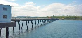
LCC Group, the company behind the Go petrol station network, says it wants to make the most of the site’s deep water jetty — which can accommodate tankers of up to 120,000 tonnes — by developing a £20 million distribution and storage terminal for the island of Ireland.

Its plans are currently before Mid & East Antrim Borough Council for assessment.

However, Whitehead community campaigners say the proposals pose a threat to wildlife in that part of Belfast Lough’s northern shore, as well as the “life line” train line between Larne and Belfast — a concern shared by rail operators Translink.

Belfast Live has much more on the story HERE.

Published in Ports & Shipping
Tagged under

Dublin Bay

Dublin Bay on the east coast of Ireland stretches over seven kilometres, from Howth Head on its northern tip to Dalkey Island in the south. It's a place most Dubliners simply take for granted, and one of the capital's least visited places. But there's more going on out there than you'd imagine.

The biggest boating centre is at Dun Laoghaire Harbour on the Bay's south shore that is home to over 1,500 pleasure craft, four waterfront yacht clubs and Ireland's largest marina.

The bay is rather shallow with many sandbanks and rocky outcrops, and was notorious in the past for shipwrecks, especially when the wind was from the east. Until modern times, many ships and their passengers were lost along the treacherous coastline from Howth to Dun Laoghaire, less than a kilometre from shore.

The Bay is a C-shaped inlet of the Irish Sea and is about 10 kilometres wide along its north-south base, and 7 km in length to its apex at the centre of the city of Dublin; stretching from Howth Head in the north to Dalkey Point in the south. North Bull Island is situated in the northwest part of the bay, where one of two major inshore sandbanks lie, and features a 5 km long sandy beach, Dollymount Strand, fronting an internationally recognised wildfowl reserve. Many of the rivers of Dublin reach the Irish Sea at Dublin Bay: the River Liffey, with the River Dodder flow received less than 1 km inland, River Tolka, and various smaller rivers and streams.

Dublin Bay FAQs

There are approximately ten beaches and bathing spots around Dublin Bay: Dollymount Strand; Forty Foot Bathing Place; Half Moon bathing spot; Merrion Strand; Bull Wall; Sandycove Beach; Sandymount Strand; Seapoint; Shelley Banks; Sutton, Burrow Beach

There are slipways on the north side of Dublin Bay at Clontarf, Sutton and on the southside at Dun Laoghaire Harbour, and in Dalkey at Coliemore and Bulloch Harbours.

Dublin Bay is administered by a number of Government Departments, three local authorities and several statutory agencies. Dublin Port Company is in charge of navigation on the Bay.

Dublin Bay is approximately 70 sq kilometres or 7,000 hectares. The Bay is about 10 kilometres wide along its north-south base, and seven km in length east-west to its peak at the centre of the city of Dublin; stretching from Howth Head in the north to Dalkey Point in the south.

Dun Laoghaire Harbour on the southside of the Bay has an East and West Pier, each one kilometre long; this is one of the largest human-made harbours in the world. There also piers or walls at the entrance to the River Liffey at Dublin city known as the Great North and South Walls. Other harbours on the Bay include Bulloch Harbour and Coliemore Harbours both at Dalkey.

There are two marinas on Dublin Bay. Ireland's largest marina with over 800 berths is on the southern shore at Dun Laoghaire Harbour. The other is at Poolbeg Yacht and Boat Club on the River Liffey close to Dublin City.

Car and passenger Ferries operate from Dublin Port to the UK, Isle of Man and France. A passenger ferry operates from Dun Laoghaire Harbour to Howth as well as providing tourist voyages around the bay.

Dublin Bay has two Islands. Bull Island at Clontarf and Dalkey Island on the southern shore of the Bay.

The River Liffey flows through Dublin city and into the Bay. Its tributaries include the River Dodder, the River Poddle and the River Camac.

Dollymount, Burrow and Seapoint beaches

Approximately 1,500 boats from small dinghies to motorboats to ocean-going yachts. The vast majority, over 1,000, are moored at Dun Laoghaire Harbour which is Ireland's boating capital.

In 1981, UNESCO recognised the importance of Dublin Bay by designating North Bull Island as a Biosphere because of its rare and internationally important habitats and species of wildlife. To support sustainable development, UNESCO’s concept of a Biosphere has evolved to include not just areas of ecological value but also the areas around them and the communities that live and work within these areas. There have since been additional international and national designations, covering much of Dublin Bay, to ensure the protection of its water quality and biodiversity. To fulfil these broader management aims for the ecosystem, the Biosphere was expanded in 2015. The Biosphere now covers Dublin Bay, reflecting its significant environmental, economic, cultural and tourism importance, and extends to over 300km² to include the bay, the shore and nearby residential areas.

On the Southside at Dun Laoghaire, there is the National Yacht Club, Royal St. George Yacht Club, Royal Irish Yacht Club and Dun Laoghaire Motor Yacht Club as well as Dublin Bay Sailing Club. In the city centre, there is Poolbeg Yacht and Boat Club. On the Northside of Dublin, there is Clontarf Yacht and Boat Club and Sutton Dinghy Club. While not on Dublin Bay, Howth Yacht Club is the major north Dublin Sailing centre.

© Afloat 2020