Displaying items by tag: Coney Island
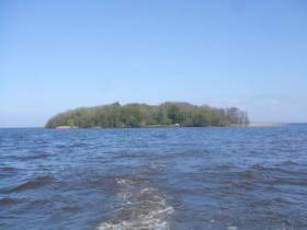
Lough Neagh Island Seeks New Caretaker
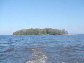
#LoughNeagh - The UK’s National Trust is seeking a new warden — or wardens — to care for the historic Coney Island in Lough Neagh, as Belfast Live reports.
The island’s restored 19th-century cottage, which until last year was home to warden Peter McClelland for almost two decades, is now available for rent.
“If you’re into gaming and watching box-sets this probably is not the place for you,” says the trust’s Edward Mason on the house, which is powered by a generator and heated by a wood-burning stove.
There will also be plenty of chores to do throughout the seasons, not least being handy with an axe.
But the mainland, an hour from Belfast, is only a 10-minute boat trip away.
And for nature lovers, the nine-acre island — also an important Neolithic site — could make the perfect home away from it all.
Belfast Live has more on the story HERE.
Lough Neagh Island’s Lone Resident Says Goodbye After Two Decades As Warden
#LoughNeagh - After two decades as warden of Coney Island in Lough Neagh, Northern Ireland’s ‘Robinson Crusoe’ has sailed on, as the Belfast Telegraph reports.
Peter McClelland won out over 400 applicants in 1998 for the prize position of caretaker of the National Trust-owned island, which has a rich history dating back to Neolithic times.
The Co Antrim man, from nearby Aghagallon, says the last 19 years “were the best years of my life” as he spent his days contentedly alone and occupied by the tasks at hand.
Indeed, from his new home in Portadown, McClelland is planning to write a book about his remarkable experience as the island’s lone resident.
The Belfast Telegraph has more on the story HERE.
RNLI Launches Text Messaging Service to Prevent Dangerous Tidal Cut–Off at Coney Island in County Sligo
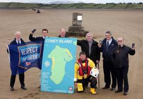
The RNLI has today launched an innovative free text message service aimed at preventing people getting caught out by dangerous tides when travelling to Coney Island in County Sligo.
In what is the first of its kind in Ireland, the RNLI text messaging service is being introduced by the charity in a direct response to a coastal safety risk identified by the local community in Sligo.
For years the causeway which provides access to Coney Island and the nature of its flooding tidal waters have presented a risk to the public who are unsure of the tide times and the appropriate times to cross from the mainland.
Sligo Bay RNLI has responded to numerous incidents around Coney Island that relate to tidal cut off and activities around the sandbanks and tidal channels. However, the volunteer lifeboat crews have often been restricted by water depth when attending these incidents especially during the crucial early phase of the flooding tide where people are starting to cut off or are bogged in.
It is hoped that the new text messaging system accompanied by signage directing people to the numbers to text, will encourage safer crossing and decision making.
Anyone planning to visit the island by car, bike or foot is encouraged to Text Coney to 53600 (from Republic of Ireland mobiles) or 81400 (from Northern Ireland/UK mobiles) to find out the safe crossing times for that day.*
The RNLI will reply with information on the best times subject to good weather conditions along with key safety messages reminding users to always leave extra time to return safely to the mainland, to never attempt to cross if the strand is covered with water and in the event of an emergency to dial 999 or 112 and ask for the Coast Guard.
Speaking at the launch of Text Coney today, Rogan Wheeldon, RNLI Community Incident Reduction Manager said: ‘This is a perfect example of a community on the coast identifying a risk and working collaboratively to help save lives at sea. By providing the public with the relevant information to make safer choices when accessing the coast it reduces their risk, the risk to our lifeboat crew, and also to those in the community that are putting their own lives at risk to help those in trouble’.
Joe Henderson, Sligo Bay RNLI Coastal Safety Officer added: ‘Over recent years our lifeboat crew at Sligo Bay RNLI has been called out many times to rescue people who have been caught out by the tide. As part of the RNLI’s work in prevention of accidental drowning we now have this wonderful texting system in place with good signage here at The Causeway and we really want to make people aware that is here and encourage locals and visitors alike to get texting when planning a visit to the beautiful Coney Island. We would like to thank everyone involved in bringing this development to fruition including the residents of Coney Island and Sligo County Council.’
The Text Coney launch comes a week after the RNLI launched Respect the Water, its annual national accidental drowning prevention campaign which will run throughout the Summer.
Respect the Water aims to highlight the risk of accidental drowning when people are near the coastline by encouraging safer behaviour both in and around the water.
The campaign is primarily aimed at males aged between 16 and 39 but the same advice is relevant for anyone visiting the coast.
The RNLI is warning of the key dangers that can lead to accidental drowning - cold water, unexpected entry into the water, and rip currents and waves.
Oscar Winning Director of 'The Shore' Returns to NI
#COASTAL NOTES - Northern Irish director Terry George has returned to a hero's welcome in his native Co Down following his Oscar win for short film The Shore, the Irish Echo reports.
The film, which was set on Coney Island near Killough on the egde of Strangford Lough, tells the story of a man who returns to his coastal community after 25 years living in the USA.
“It’s great to come home and to visit everyone who made the film possible, the people who were in it, go back and see our neighbors,” said George on landing in Belfast. “You kind of hope that you’ll bring back the awards here to Ireland.”
The Shore is also a family effort, as it was produced by the director's daughter Oonagh George.


