Menu

Ireland's sailing, boating & maritime magazine

Dublin Bay Boating News and Information

Displaying items by tag: DART Grand Canal Dock

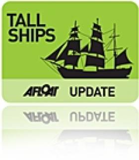
The arrival of the largest and oldest Norwegian tallship the barque S/S Statsraad Lehmkuhl into Dublin Port yesterday made for an impressive sight, even without her sails set, writes Jehan Ashmore.

At nearly a century-old the square-rigged ship eased her way through the East-Link toll bridge where she proceeded to berth at Sir John Rogersons Quay, where she will be open to the public today between 12:00 – 16:30 and tomorrow,Saturday the 20th August from 10:00 –12:00. Her berth is downriver of the Samuel Beckett swing-bridge and the nearest DART stations are at Grand Canal Dock and Pearse St.
statsraad_1
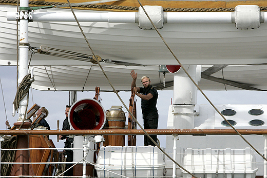
Statsraad Lehmkuhl is 321-feet long and the barque is also one of the largest three-masted sailing ships in the world. The height from the water-line to the top of the mainmast is 240-feet and in total she carries 22 sails which cover an area of over 2,000 square metres. Under canvass she can achieve 18 knots or when under motor-power her 1,125hp diesel engine manages 11 knots. 
statsraad_2
As reported on Afloat.ie the steel-hulled barque departed her homeport of Bergen last week on a voyage across the North Sea to include a call to Stornoway on the Isle of Lewis. She was built in 1914 originally for the German Merchant Marine and at nearly a century-old she has had a colourful career having changed hands between Germany and Britain during both World Wars.
Since 1978 she has been with her current operators the Statsraad Lehmkuhl Foundation, based in the Nordic's country's second largest city. For further information about the 1,516-tonnes vessel specifications click HERE and interior illustration of deck layout click HERE.
statsraad_3

Her arrival marks nearly a year in advance to Dublin City welcoming the return of the Tall Ships Races, presented by Szczecin and organised by Sail Training International. The capital last hosted the event in 1998 and next year up to 100 tall ships are to sail into the capital which will be the final host port for four days between 23rd-26th August 2012.

statsraad_4

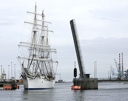
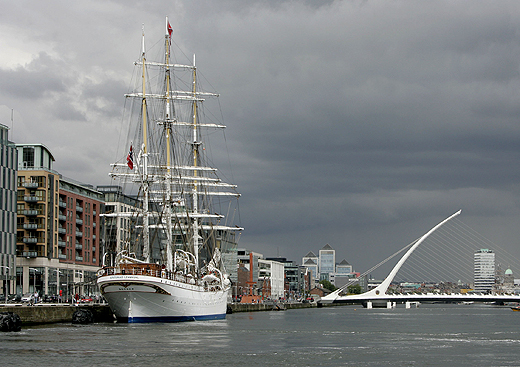
Tall Ship S/S Statsraad Lehmkuh in Dublin Bay yesterday. Images: Iain White

The celebration of sail is expected to draw entrants from as far away as Chile, Mexico, Argentina, USA and European and Baltic countries including Italy and Norway will chart their course to Dublin. It is hoped that the event will attract over a million visitors to the city, topping the 500,000 spectators who thronged the Waterford quays during this year's tall ship race gathering.

tallship_jehan

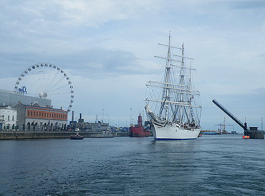
Photo: Jehan Ashmore

Published in Tall Ships

Dublin Bay

Dublin Bay on the east coast of Ireland stretches over seven kilometres, from Howth Head on its northern tip to Dalkey Island in the south. It's a place most Dubliners simply take for granted, and one of the capital's least visited places. But there's more going on out there than you'd imagine.

The biggest boating centre is at Dun Laoghaire Harbour on the Bay's south shore that is home to over 1,500 pleasure craft, four waterfront yacht clubs and Ireland's largest marina.

The bay is rather shallow with many sandbanks and rocky outcrops, and was notorious in the past for shipwrecks, especially when the wind was from the east. Until modern times, many ships and their passengers were lost along the treacherous coastline from Howth to Dun Laoghaire, less than a kilometre from shore.

The Bay is a C-shaped inlet of the Irish Sea and is about 10 kilometres wide along its north-south base, and 7 km in length to its apex at the centre of the city of Dublin; stretching from Howth Head in the north to Dalkey Point in the south. North Bull Island is situated in the northwest part of the bay, where one of two major inshore sandbanks lie, and features a 5 km long sandy beach, Dollymount Strand, fronting an internationally recognised wildfowl reserve. Many of the rivers of Dublin reach the Irish Sea at Dublin Bay: the River Liffey, with the River Dodder flow received less than 1 km inland, River Tolka, and various smaller rivers and streams.

Dublin Bay FAQs

There are approximately ten beaches and bathing spots around Dublin Bay: Dollymount Strand; Forty Foot Bathing Place; Half Moon bathing spot; Merrion Strand; Bull Wall; Sandycove Beach; Sandymount Strand; Seapoint; Shelley Banks; Sutton, Burrow Beach

There are slipways on the north side of Dublin Bay at Clontarf, Sutton and on the southside at Dun Laoghaire Harbour, and in Dalkey at Coliemore and Bulloch Harbours.

Dublin Bay is administered by a number of Government Departments, three local authorities and several statutory agencies. Dublin Port Company is in charge of navigation on the Bay.

Dublin Bay is approximately 70 sq kilometres or 7,000 hectares. The Bay is about 10 kilometres wide along its north-south base, and seven km in length east-west to its peak at the centre of the city of Dublin; stretching from Howth Head in the north to Dalkey Point in the south.

Dun Laoghaire Harbour on the southside of the Bay has an East and West Pier, each one kilometre long; this is one of the largest human-made harbours in the world. There also piers or walls at the entrance to the River Liffey at Dublin city known as the Great North and South Walls. Other harbours on the Bay include Bulloch Harbour and Coliemore Harbours both at Dalkey.

There are two marinas on Dublin Bay. Ireland's largest marina with over 800 berths is on the southern shore at Dun Laoghaire Harbour. The other is at Poolbeg Yacht and Boat Club on the River Liffey close to Dublin City.

Car and passenger Ferries operate from Dublin Port to the UK, Isle of Man and France. A passenger ferry operates from Dun Laoghaire Harbour to Howth as well as providing tourist voyages around the bay.

Dublin Bay has two Islands. Bull Island at Clontarf and Dalkey Island on the southern shore of the Bay.

The River Liffey flows through Dublin city and into the Bay. Its tributaries include the River Dodder, the River Poddle and the River Camac.

Dollymount, Burrow and Seapoint beaches

Approximately 1,500 boats from small dinghies to motorboats to ocean-going yachts. The vast majority, over 1,000, are moored at Dun Laoghaire Harbour which is Ireland's boating capital.

In 1981, UNESCO recognised the importance of Dublin Bay by designating North Bull Island as a Biosphere because of its rare and internationally important habitats and species of wildlife. To support sustainable development, UNESCO’s concept of a Biosphere has evolved to include not just areas of ecological value but also the areas around them and the communities that live and work within these areas. There have since been additional international and national designations, covering much of Dublin Bay, to ensure the protection of its water quality and biodiversity. To fulfil these broader management aims for the ecosystem, the Biosphere was expanded in 2015. The Biosphere now covers Dublin Bay, reflecting its significant environmental, economic, cultural and tourism importance, and extends to over 300km² to include the bay, the shore and nearby residential areas.

On the Southside at Dun Laoghaire, there is the National Yacht Club, Royal St. George Yacht Club, Royal Irish Yacht Club and Dun Laoghaire Motor Yacht Club as well as Dublin Bay Sailing Club. In the city centre, there is Poolbeg Yacht and Boat Club. On the Northside of Dublin, there is Clontarf Yacht and Boat Club and Sutton Dinghy Club. While not on Dublin Bay, Howth Yacht Club is the major north Dublin Sailing centre.

© Afloat 2020