Menu

Ireland's sailing, boating & maritime magazine

Dublin Bay Boating News and Information

Displaying items by tag: Dun Laoghaire East Pier

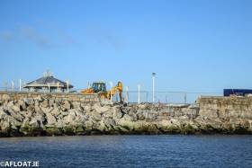
Repairs are underway to the East Pier that was damaged in March's Storm Emma. The extent of the damage is visible from this landward photograph that reveals a breach in the harbour wall close to the bandstand area.

There was 'substantial damage' to Dun Laoghaire's East Pier following Storm Emma. 

Dublin harbours bore the brunt of the easterly storm when high seas caused flooding and infrastructural damage with the damage to the country's largest man made harbour revealed in these pictures here.

The bad news for the harbour, following its bicentenary year, came as Dun Laoghaire-Rathdown County Council recommended the dissolution of Dun Laoghaire Harbour Company and the transfer of its assets to the local authority that has since been completed.

The 'soft' re-opening of the Maritime Institute of Ireland's (M.I.I.) renovated maritime museum in Dun Laoghaire is this Sunday, though the opening is dependent to fire officer's approval, writes Jehan Ashmore.
For several years the museum has been closed due to extensive renovation that was urgently required in the former Mariners Church built in 1837. In 1971 the church closed and the museum moved into the building in 1976. The church retains many of the original features, including the prisoner's docks in the gallery and magnificent stained glass windows. Externally the building has also undergone external renovation with extensive cleaning of the structure's stonework.
It is situated between the town's main shopping thoroughfare on Georges Street Upper and Dun Laoghaire Harbour's East Pier. If you are arriving to Dun Laoghaire by DART, why not take the short stroll to the museum along The 'Metals' as far as the Christ the King sculpture opposite the East Pier. From here there are steps that lead up to Haigh Terrace and the museum.

At the end of this month the M.I.I. will celebrate the 70th anniversary of its foundation and it is the intention of the voluntary run museum to 'officially' re-open in March 2012.

To read more about the renovation programme click HERE. If you would like to assist through voluntary work, fund-raising activities or make a donation in addition to keeping abreast of the latest developments visit www.mariner.ie


View Larger Map
Published in Dublin Bay
On a rare occasion both the Marine Institute's research vessels docked in both Dublin Bay ports today, normally these vessels operate mostly off the western seaboard and using their home-port of Galway Harbour, writes Jehan Ashmore.
The 65m RV Celtic Explorer (2002 /2,425grt) made an early morning call to Dublin Port's Ocean Pier. Her smaller fleet-mate RV Celtic Voyager (1996/340grt) made a midday arrival to Dun Laoghaire Harbour's East Pier. She moored at the same berth last month, as previously reported on Afloat.ie The larger vessel has a greater range capability while the smaller vessel covers more inshore-work throughout the Irish coastline.

According to the vessels survey schedules, RV Celtic Explorer had today completed fisheries demersal surveys which started in Galway on 23 September. The near fortnight-long survey was conducted in the ICES area VI, under the direction of chief scientist, Dave Stokes.

On Friday she embarks on a herring acoustic survey which is to take place in the Celtic Sea and the south-west. This survey will be under chief scientist Ciaran O'Donnell and is to de-mobilise in Cork on 27 October. To read more about her 2011 survey programme click HERE.

Across Dublin Bay in neighbouring Dun Laoghaire, the 31m RV Celtic Voyager is currently nearing the end of a month-long hydrography survey of the Celtic Sea. The survey had started in Howth Harbour on 17 September under chief scientist Kevin Sheehan. For the time-being she remains moored in Dun Laoghaire prior to resuming survey work which will continue until the vessel de-mobilises in Rosslare in mid-October. To find out more about her remaining surveys for this year click HERE.

On the surveys outlined they are conducted on behalf of Marine Institute scientists, though the vessels are also allocated ship-time for use of third parties. These include government departments and agencies, universities, research institutes and industry. For further information on the research vessels, survey schedules etc can be found by visiting: www.marine.ie/home/Research+Vessels.htm


Published in Marine Science
Tomorrow morning walkers at Dun Laoghaire Harbour's pier-heads will have close-up views of the departing Solitaire du Figaro race fleet and a French Navy patrol vessel, writes Jehan Ashmore.
At 11 o'clock the third race-leg heads for Les Sables d'Olonne, Vendée, a distance of 475 miles. They will be accompanied by the (OPV) offshore patrol vessel PSP Cormoran (P677) which is scheduled to depart in advance at 10 o'clock so to allow the boats to gather in Dublin Bay. From there the PSP Cormoran will act as an escort 'guard-ship'. A role in which she has been engaged since the prestigious solo-sailor race started a fortnight ago.

The 447 tonnes OPV provides communication liaison and assistance should the forty six sailors require during the arduous race including SAR. As such the vessel can deploy a rapid response high speed RIB-craft from an internal dock-well located at the stern.

Otherwise the RIB is used to board fishing vessels as part of fishery monitoring duties and patrolling France's Exclusive Economic Zone out to 200 nautical miles (370 km). She is a Flamant class OPV and was built in 1997 by the Cherbourg based shipyard Constructions Mécaniques de Normandie. The 54m/177-ft craft is equipped with two 12.7mm machine guns.

As Dun Laoghaire is the only international port of call during the four-leg stages of the 1,695 nautical miles (3,390kms) the hosting of the Irish harbour is a welcomed boost to the sailing community and the local economy. Leading off the Carlisle Pier are pontoons where the one-design boats are moored and opposite is the East Pier jetty berth where the PSP Cormoran is docked.

Also at the East Pier is a festival market which is part of the Festival des Bateaux. The three-day festival ends tomorrow and was organised by the race-hosts the National Yacht Club, the Dun Laoghaire Harbour Company and Dun Laoghaire Rathdown County Council. For further festival details click HERE.

The presence of a foreign naval visitor to the harbour was more commonplace particularly during festivals held in the 1980's. In addition to the French, navies from Belgium, The Netherlands were regular festival participants.

Published in Navy

Dublin Bay

Dublin Bay on the east coast of Ireland stretches over seven kilometres, from Howth Head on its northern tip to Dalkey Island in the south. It's a place most Dubliners simply take for granted, and one of the capital's least visited places. But there's more going on out there than you'd imagine.

The biggest boating centre is at Dun Laoghaire Harbour on the Bay's south shore that is home to over 1,500 pleasure craft, four waterfront yacht clubs and Ireland's largest marina.

The bay is rather shallow with many sandbanks and rocky outcrops, and was notorious in the past for shipwrecks, especially when the wind was from the east. Until modern times, many ships and their passengers were lost along the treacherous coastline from Howth to Dun Laoghaire, less than a kilometre from shore.

The Bay is a C-shaped inlet of the Irish Sea and is about 10 kilometres wide along its north-south base, and 7 km in length to its apex at the centre of the city of Dublin; stretching from Howth Head in the north to Dalkey Point in the south. North Bull Island is situated in the northwest part of the bay, where one of two major inshore sandbanks lie, and features a 5 km long sandy beach, Dollymount Strand, fronting an internationally recognised wildfowl reserve. Many of the rivers of Dublin reach the Irish Sea at Dublin Bay: the River Liffey, with the River Dodder flow received less than 1 km inland, River Tolka, and various smaller rivers and streams.

Dublin Bay FAQs

There are approximately ten beaches and bathing spots around Dublin Bay: Dollymount Strand; Forty Foot Bathing Place; Half Moon bathing spot; Merrion Strand; Bull Wall; Sandycove Beach; Sandymount Strand; Seapoint; Shelley Banks; Sutton, Burrow Beach

There are slipways on the north side of Dublin Bay at Clontarf, Sutton and on the southside at Dun Laoghaire Harbour, and in Dalkey at Coliemore and Bulloch Harbours.

Dublin Bay is administered by a number of Government Departments, three local authorities and several statutory agencies. Dublin Port Company is in charge of navigation on the Bay.

Dublin Bay is approximately 70 sq kilometres or 7,000 hectares. The Bay is about 10 kilometres wide along its north-south base, and seven km in length east-west to its peak at the centre of the city of Dublin; stretching from Howth Head in the north to Dalkey Point in the south.

Dun Laoghaire Harbour on the southside of the Bay has an East and West Pier, each one kilometre long; this is one of the largest human-made harbours in the world. There also piers or walls at the entrance to the River Liffey at Dublin city known as the Great North and South Walls. Other harbours on the Bay include Bulloch Harbour and Coliemore Harbours both at Dalkey.

There are two marinas on Dublin Bay. Ireland's largest marina with over 800 berths is on the southern shore at Dun Laoghaire Harbour. The other is at Poolbeg Yacht and Boat Club on the River Liffey close to Dublin City.

Car and passenger Ferries operate from Dublin Port to the UK, Isle of Man and France. A passenger ferry operates from Dun Laoghaire Harbour to Howth as well as providing tourist voyages around the bay.

Dublin Bay has two Islands. Bull Island at Clontarf and Dalkey Island on the southern shore of the Bay.

The River Liffey flows through Dublin city and into the Bay. Its tributaries include the River Dodder, the River Poddle and the River Camac.

Dollymount, Burrow and Seapoint beaches

Approximately 1,500 boats from small dinghies to motorboats to ocean-going yachts. The vast majority, over 1,000, are moored at Dun Laoghaire Harbour which is Ireland's boating capital.

In 1981, UNESCO recognised the importance of Dublin Bay by designating North Bull Island as a Biosphere because of its rare and internationally important habitats and species of wildlife. To support sustainable development, UNESCO’s concept of a Biosphere has evolved to include not just areas of ecological value but also the areas around them and the communities that live and work within these areas. There have since been additional international and national designations, covering much of Dublin Bay, to ensure the protection of its water quality and biodiversity. To fulfil these broader management aims for the ecosystem, the Biosphere was expanded in 2015. The Biosphere now covers Dublin Bay, reflecting its significant environmental, economic, cultural and tourism importance, and extends to over 300km² to include the bay, the shore and nearby residential areas.

On the Southside at Dun Laoghaire, there is the National Yacht Club, Royal St. George Yacht Club, Royal Irish Yacht Club and Dun Laoghaire Motor Yacht Club as well as Dublin Bay Sailing Club. In the city centre, there is Poolbeg Yacht and Boat Club. On the Northside of Dublin, there is Clontarf Yacht and Boat Club and Sutton Dinghy Club. While not on Dublin Bay, Howth Yacht Club is the major north Dublin Sailing centre.

© Afloat 2020