Menu

Ireland's sailing, boating & maritime magazine

Dublin Bay Boating News and Information

Displaying items by tag: Eagle Island

The Irish Mirror reports that a man has died after a fishing boat capsized off the Mayo coast yesterday afternoon (Tuesday 10 April).

It’s understood that the deceased was a man in his 50s from North Mayo. He was one of three men recovered from a life raft some 16 miles off Eagle Island after their vessel sank.

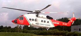
Ballyglass RNLI and the Irish Coast Guard’s Sligo-based helicopter Rescue 118 were immediately tasked to search the area when a Mayday broadcast was picked up shortly after 12.30pm.

Rescue 118 spotted flares less than an hour later and proceeded to airlift the casualties for transfer to Sligo University Hospital.

Published in News Update

#lighthouse – A challenging lighthouse redevelopment project has been completed on one of the most testing sites on the Irish Atlantic coast. The Commissioners of Irish Lights (CIL) has completed a re-construction and modernisation project at Eagle Island Lighthouse in Co. Mayo – a landmark lighthouse safeguarding Ireland's north-westcoast. The new light is being commissioned today.

This demanding project on Eagle Island consisted of the replacement of the entire upper part of the lighthousestructure using a helicopter. This is one of the mostchallenging construction projects undertaken by CIL in recent years.

Captain Robert McCabe, Director of the Operations and Navigation Services with CIL stated "Eagle Island lighthouse stands 220 feet above the Atlantic ocean, yetover the years waves from winter storms have damaged buildings and equipment in the walled lighthouse compound. Eagle Island lighthouse must provide a reliable and effective aid to navigation in extreme conditions because it is, at these times, when marinersmost require CIL aids. The new light on Eagle Island will provide a high quality, highly reliable 18 mile LED light and, for the first time, an automatic identification system. The solar battery system will remove the requirement for diesel generation with consequent environmental benefits and maintenance savings."

The Commissioners of Irish Lights (CIL) is actively involved in consolidating its coastal infrastructure which is the latest chapter in technology change that CIL is currently implementing; first came automation, then solarisation and now consolidation. The overriding purpose of consolidation is to provide a low-maintenance, low-energy, and low-cost Aids to Navigation service around the Irish Coast.

Eagle Island's unique location saw the establishment oftwo lighthouses on the island, both completed in 1835.Because of its close proximity to the continental shelfEagle Island experiences unusually large waves and over the years the lanterns have regularly been damaged by waves and water-borne rocks.

Due to these ferocious conditions, a huge storm wall was constructed surrounding the lighthouses. This wall was destroyed by the sea, reinforced and eventually abandoned after a particularly large storm in 1894 when it was decided to abandon the lower lighthouse.

The lighthouse keepers were withdrawn with the automation of the current lighthouse in 1988.

After almost 200 years of guiding mariners to safety, the lantern room and domed roof of the lighthouse tower had reached the end of their working life. The old lighthouse dome, the lantern room, the large glass lens and the bath of mercury in which the lens rotated were all removed. They were replaced with a stainless steel structuredesigned by CIL to withstand the aggressive and relentless marine environment.

This structure was manufactured by Shortt Stainless Steel in Limerick which incorporates a new roof, a guarded access platform and light pedestals. The roof also supports new waterproof and weather resistant flashing LED (light emitting diode) lights.

A temporary works system was also designed to access the previous dome for demolition works. This platformincorporated the means to manhandle heavy equipmentand the helicopter deck on which to land the new dome.Constructing all of this on top of the lighthouse tower was extremely challenging.

Commenting on the success of this unique construction challenge, Captain Robert McCabe of CIL stated "The CIL team who delivered this complex project have demonstrated exceptional engineering, planning and construction skills and made a positive contribution to safety at sea and the marine environment."

Published in Lighthouses

Dublin Bay

Dublin Bay on the east coast of Ireland stretches over seven kilometres, from Howth Head on its northern tip to Dalkey Island in the south. It's a place most Dubliners simply take for granted, and one of the capital's least visited places. But there's more going on out there than you'd imagine.

The biggest boating centre is at Dun Laoghaire Harbour on the Bay's south shore that is home to over 1,500 pleasure craft, four waterfront yacht clubs and Ireland's largest marina.

The bay is rather shallow with many sandbanks and rocky outcrops, and was notorious in the past for shipwrecks, especially when the wind was from the east. Until modern times, many ships and their passengers were lost along the treacherous coastline from Howth to Dun Laoghaire, less than a kilometre from shore.

The Bay is a C-shaped inlet of the Irish Sea and is about 10 kilometres wide along its north-south base, and 7 km in length to its apex at the centre of the city of Dublin; stretching from Howth Head in the north to Dalkey Point in the south. North Bull Island is situated in the northwest part of the bay, where one of two major inshore sandbanks lie, and features a 5 km long sandy beach, Dollymount Strand, fronting an internationally recognised wildfowl reserve. Many of the rivers of Dublin reach the Irish Sea at Dublin Bay: the River Liffey, with the River Dodder flow received less than 1 km inland, River Tolka, and various smaller rivers and streams.

Dublin Bay FAQs

There are approximately ten beaches and bathing spots around Dublin Bay: Dollymount Strand; Forty Foot Bathing Place; Half Moon bathing spot; Merrion Strand; Bull Wall; Sandycove Beach; Sandymount Strand; Seapoint; Shelley Banks; Sutton, Burrow Beach

There are slipways on the north side of Dublin Bay at Clontarf, Sutton and on the southside at Dun Laoghaire Harbour, and in Dalkey at Coliemore and Bulloch Harbours.

Dublin Bay is administered by a number of Government Departments, three local authorities and several statutory agencies. Dublin Port Company is in charge of navigation on the Bay.

Dublin Bay is approximately 70 sq kilometres or 7,000 hectares. The Bay is about 10 kilometres wide along its north-south base, and seven km in length east-west to its peak at the centre of the city of Dublin; stretching from Howth Head in the north to Dalkey Point in the south.

Dun Laoghaire Harbour on the southside of the Bay has an East and West Pier, each one kilometre long; this is one of the largest human-made harbours in the world. There also piers or walls at the entrance to the River Liffey at Dublin city known as the Great North and South Walls. Other harbours on the Bay include Bulloch Harbour and Coliemore Harbours both at Dalkey.

There are two marinas on Dublin Bay. Ireland's largest marina with over 800 berths is on the southern shore at Dun Laoghaire Harbour. The other is at Poolbeg Yacht and Boat Club on the River Liffey close to Dublin City.

Car and passenger Ferries operate from Dublin Port to the UK, Isle of Man and France. A passenger ferry operates from Dun Laoghaire Harbour to Howth as well as providing tourist voyages around the bay.

Dublin Bay has two Islands. Bull Island at Clontarf and Dalkey Island on the southern shore of the Bay.

The River Liffey flows through Dublin city and into the Bay. Its tributaries include the River Dodder, the River Poddle and the River Camac.

Dollymount, Burrow and Seapoint beaches

Approximately 1,500 boats from small dinghies to motorboats to ocean-going yachts. The vast majority, over 1,000, are moored at Dun Laoghaire Harbour which is Ireland's boating capital.

In 1981, UNESCO recognised the importance of Dublin Bay by designating North Bull Island as a Biosphere because of its rare and internationally important habitats and species of wildlife. To support sustainable development, UNESCO’s concept of a Biosphere has evolved to include not just areas of ecological value but also the areas around them and the communities that live and work within these areas. There have since been additional international and national designations, covering much of Dublin Bay, to ensure the protection of its water quality and biodiversity. To fulfil these broader management aims for the ecosystem, the Biosphere was expanded in 2015. The Biosphere now covers Dublin Bay, reflecting its significant environmental, economic, cultural and tourism importance, and extends to over 300km² to include the bay, the shore and nearby residential areas.

On the Southside at Dun Laoghaire, there is the National Yacht Club, Royal St. George Yacht Club, Royal Irish Yacht Club and Dun Laoghaire Motor Yacht Club as well as Dublin Bay Sailing Club. In the city centre, there is Poolbeg Yacht and Boat Club. On the Northside of Dublin, there is Clontarf Yacht and Boat Club and Sutton Dinghy Club. While not on Dublin Bay, Howth Yacht Club is the major north Dublin Sailing centre.

© Afloat 2020