Menu

Ireland's sailing, boating & maritime magazine

Dublin Bay Boating News and Information

Displaying items by tag: East Pier Dun Laoghaire

Works have recently begun to repair damage in Dun Laoghaire Harbour caused by a storm from almost two years ago, however further bad weather looms as Storm Dennis is to sweep in this weekend, writes Jehan Ashmore.

As Afloat reported in November, a landing-craft vessel in the harbour assisted a contractor which Dun Laoghaire-Rathdown County Council tasked to repair damage notably at the East Pier following Storm Emma in March 2018. Due to access issues, diggers were transported by sea to land ashore on both the seaward sides of the West and East Piers.

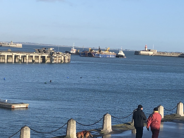
Ironically Storm Ciara made its presence felt in regards to repair works required at the East Pier. As Afloat also reported, a section of the pier's revetments removed by Storm Emma were due to receive replenished rock armour. This work was expected to be completed by Christmas, however, it was only last week that a tug towing a barge laden with 1,700 tonnes of Cornish granite arrived at the harbour.

As the weather abated, the tug Vanguard which made the delivery voyage, was joined in the harbour on Wednesday by Wicklow based tug, AMS Retriever to assist in the short-distance towing operation. The tugs departed St. Michael's Pier along with the barge that was positioned in Scotman's Bay in close proximity off the East Pier.

Barge rocks Dun laoghaire 0372
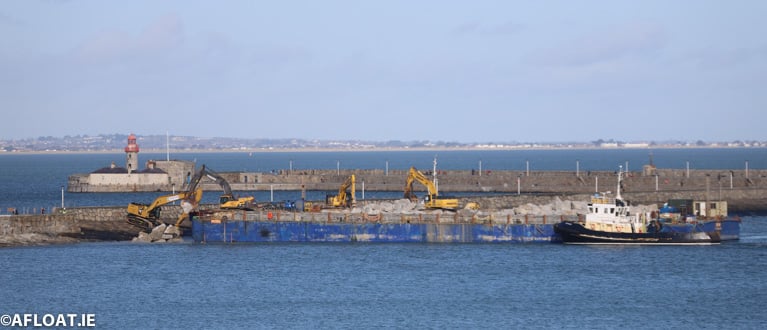
The Vanguard with accompanying tugs offloads its rock cargo at the back of Dun Laoghaire's East Pier Photo: Afloat

According to DLRCoCo, the works at the East Pier are scheduled to be completed by the end of February.

On a related note to the weather in the harbour, Storm Ciara led to three Belgium registered trawlers forced to take refuge by sheltering within the harbour.

The trio of beam-trawlers berthed alongside Carlisle Pier involved Avatar (Z-333) and rafted alongside Francine (Z 90). While the third trawler, De Marie Louise (Z 47) berthed ahead but nearer to the pierhead.

As weather conditions improved, the trawlers departed back into the Irish Sea.

Published in Dublin Bay
#MARITIME MUSEUM – Independent T.D.'s Richard Boyd Barrett, Luke'Ming' Flanagan and Mick Wallace are to don 'conservative' attire, albeit briefly!..wearing collars, ties and suits for a 'Fashion Show Extavaganza' to aid the re-opening of the National Maritime Museum in Dun Laoghaire, writes Jehan Ashmore.
In addition to the appearance of the public representatives, local fashion from Dun Laoghaire, Glasthule and Monkstown will be modelled by professional models. There will also be Captain Roger's Treasure Raffle with great prizes and big surprizes.

The fundraiser event which is in aid of the Development Fund of the museum, is to take place this Thursday evening (8 p.m.) on 10th November, in the National Yacht Club (NYC) along the waterfront of Dun Laoghaire Harbour, close to the East Pier.

Tickets costing €20 are available from the Maritime Institute of Ireland's (M.I.I.) museum office located on the top floor of the Dun Laoghaire Shopping Centre, in local fashion shops and by contacting (01) 214 3964.

At the end of last month, the M.I.I. celebrated its 70th anniversary which was founded in 1941. To read more about the museum which is undergoing renovation and due to re-open in March 2012 click HERE and to read other news and developments visit www.mariner.ie

Published in Boating Fixtures
A French Navy offshore patrol vessel PSP Cormoran (P6277) that has been escorting the second leg of the La Solitaire du Figaro Race to Dun Laoghaire, is to dock tomorrow morning, writes Jehan Ashmore.
The race fleet departed Ouistreham (Caen) last Sunday on the 470 nautical mile course to Dun Laoghaire, the only international port of call of the prestigious race. This morning the fleet are offshore of Land's End.

To celebrate the stopover of the four-stage 1,695 nautical mile (3,390 km) race, Dun Laoghaire Rathdown County Council, Dun Laoghaire Harbour Company and the National Yacht Club have joined forces to create the Festival des Bateaux (12-14 Aug).

A festival highlight will be a fireworks display which be held on Friday night at 10pm on the East Pier. In addition during the three-day festival programme includes live bands, street entertainment and a market on the Carlisle Pier. For more details and times of the free event go to www.dlrevents.ie

Visitors to the East Pier can take a closer view of the PSP Cormoran from the quayside where the 23 knot offshore patrol vessel (OPV) will be berthed. The Flamant class (OPV) entered service in 1997 after completion by Constructions Mécaniques de Normandie, Cherbourg, where the 477 tonnes vessel is based.

The 54m/177-ft vessel has two 12.7mm machine guns and is used for fishery monitoring, SAR and patrolling France's Exclusive Economic Zone out to 200 nautical miles / 370 km. In addition she is equipped with a high speed RIB-craft that can be deployed from an internal dock-well at the stern.

Published in Navy

Dublin Bay

Dublin Bay on the east coast of Ireland stretches over seven kilometres, from Howth Head on its northern tip to Dalkey Island in the south. It's a place most Dubliners simply take for granted, and one of the capital's least visited places. But there's more going on out there than you'd imagine.

The biggest boating centre is at Dun Laoghaire Harbour on the Bay's south shore that is home to over 1,500 pleasure craft, four waterfront yacht clubs and Ireland's largest marina.

The bay is rather shallow with many sandbanks and rocky outcrops, and was notorious in the past for shipwrecks, especially when the wind was from the east. Until modern times, many ships and their passengers were lost along the treacherous coastline from Howth to Dun Laoghaire, less than a kilometre from shore.

The Bay is a C-shaped inlet of the Irish Sea and is about 10 kilometres wide along its north-south base, and 7 km in length to its apex at the centre of the city of Dublin; stretching from Howth Head in the north to Dalkey Point in the south. North Bull Island is situated in the northwest part of the bay, where one of two major inshore sandbanks lie, and features a 5 km long sandy beach, Dollymount Strand, fronting an internationally recognised wildfowl reserve. Many of the rivers of Dublin reach the Irish Sea at Dublin Bay: the River Liffey, with the River Dodder flow received less than 1 km inland, River Tolka, and various smaller rivers and streams.

Dublin Bay FAQs

There are approximately ten beaches and bathing spots around Dublin Bay: Dollymount Strand; Forty Foot Bathing Place; Half Moon bathing spot; Merrion Strand; Bull Wall; Sandycove Beach; Sandymount Strand; Seapoint; Shelley Banks; Sutton, Burrow Beach

There are slipways on the north side of Dublin Bay at Clontarf, Sutton and on the southside at Dun Laoghaire Harbour, and in Dalkey at Coliemore and Bulloch Harbours.

Dublin Bay is administered by a number of Government Departments, three local authorities and several statutory agencies. Dublin Port Company is in charge of navigation on the Bay.

Dublin Bay is approximately 70 sq kilometres or 7,000 hectares. The Bay is about 10 kilometres wide along its north-south base, and seven km in length east-west to its peak at the centre of the city of Dublin; stretching from Howth Head in the north to Dalkey Point in the south.

Dun Laoghaire Harbour on the southside of the Bay has an East and West Pier, each one kilometre long; this is one of the largest human-made harbours in the world. There also piers or walls at the entrance to the River Liffey at Dublin city known as the Great North and South Walls. Other harbours on the Bay include Bulloch Harbour and Coliemore Harbours both at Dalkey.

There are two marinas on Dublin Bay. Ireland's largest marina with over 800 berths is on the southern shore at Dun Laoghaire Harbour. The other is at Poolbeg Yacht and Boat Club on the River Liffey close to Dublin City.

Car and passenger Ferries operate from Dublin Port to the UK, Isle of Man and France. A passenger ferry operates from Dun Laoghaire Harbour to Howth as well as providing tourist voyages around the bay.

Dublin Bay has two Islands. Bull Island at Clontarf and Dalkey Island on the southern shore of the Bay.

The River Liffey flows through Dublin city and into the Bay. Its tributaries include the River Dodder, the River Poddle and the River Camac.

Dollymount, Burrow and Seapoint beaches

Approximately 1,500 boats from small dinghies to motorboats to ocean-going yachts. The vast majority, over 1,000, are moored at Dun Laoghaire Harbour which is Ireland's boating capital.

In 1981, UNESCO recognised the importance of Dublin Bay by designating North Bull Island as a Biosphere because of its rare and internationally important habitats and species of wildlife. To support sustainable development, UNESCO’s concept of a Biosphere has evolved to include not just areas of ecological value but also the areas around them and the communities that live and work within these areas. There have since been additional international and national designations, covering much of Dublin Bay, to ensure the protection of its water quality and biodiversity. To fulfil these broader management aims for the ecosystem, the Biosphere was expanded in 2015. The Biosphere now covers Dublin Bay, reflecting its significant environmental, economic, cultural and tourism importance, and extends to over 300km² to include the bay, the shore and nearby residential areas.

On the Southside at Dun Laoghaire, there is the National Yacht Club, Royal St. George Yacht Club, Royal Irish Yacht Club and Dun Laoghaire Motor Yacht Club as well as Dublin Bay Sailing Club. In the city centre, there is Poolbeg Yacht and Boat Club. On the Northside of Dublin, there is Clontarf Yacht and Boat Club and Sutton Dinghy Club. While not on Dublin Bay, Howth Yacht Club is the major north Dublin Sailing centre.

© Afloat 2020