Menu

Ireland's sailing, boating & maritime magazine

Dublin Bay Boating News and Information

Displaying items by tag: Easter Rising

I love Irish history. It is the story of the Irish people, living in an island nation. But I have always wondered about a maritime, a shipping aspect of the Easter Rising, the commemoration of which has raised the profile of our evolution as an independent country. And that is – would it actually have been possible for the AUD, the German ship with weapons and ammunition for the Irish Volunteers, by arrangement with Roger Casement, to have landed its cargo in Tralee Bay, which is the accepted historical conception of that part of the plans for the Rising.
I have always wondered about the challenge and difficulties of getting 20,000 rifles, 10 machine guns and 3.5 million rounds of ammunition off that ship in the conditions and shipping facilities of Tralee Bay and the probably only realistic landing site at Fenit in 1916.
Was it to have been done at Fenit? In the facilities there for unloading in 1916 would that actually have been possible? Was it thought that the cargo might be got off into open boats in the Bay?
I got my opportunity to ask that question of an expert on the period last weekend, Dr. John Treacy, who was recently awarded his Ph.D. from Mary Immaculate College in Limerick for his doctoral thesis about the Naval Service.
He answered me very directly: “I would say absolutely not.”
He had a lot more to say about the AUD and the plan for it to provide weaponry for the Volunteers when I interviewed him at a seminar which underlined the huge public interest in Irish maritime affairs. “Revolution on an Island -The Maritime Aspects of the 1916 Rebellion,” was organised by the Irish Maritime Forum. It was booked out. People attended from all over the country. There was even a waiting list for places at the National Maritime College in Ringaskiddy on the edge of Cork Harbour where it was held.
Dr. Treacy spoke on ‘The Silent Shore – The Attempt to land arms at Banna Strand from the AUD.” It is a fascinating part of Irish history and the maritime involvement. If you have any interest at all in our history, I urge you to listen to him below on my programme, THIS ISLAND NATION.
It was also an unusual experience for me at that seminar to find myself being quoted at the outset. It was for my description of Ireland as an “island nation” which is accepted by the Forum, which is an independent think-tank on maritime matters. But the Forum had a qualification – “Ireland is not yet a maritime nation”
You can hear more about this from retired Naval officer, Capt. James Robinson, who discusses it with me on behalf of the Forum. Not a lot has been heard about the Forum in public, but this seminar was a revelation.
Simon McGibney, the new Commodore of the Irish Cruiser Racing Association, talks to me about his plans for this year’s sailing and the retirement of one of the country’s longest-serving lifeboatmen, from the RNLI Rosslare Station, is reported while there is also good advice on the programme about using vehicles to launch and recover boats from slipways in view of the Buncrana tragedy.
THIS ISLAND NATION reports on the marine traditions, culture, history and modern maritime developments of our island nation. I hope you enjoy it and would welcome your comments. You can Email to: [email protected]

Published in Island Nation

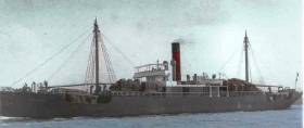
#CORK HARBOUR NEWS - Two anchors were recovered recently from the wreck of the historic Easter Rising gun running vessel in Cork Harbour, as The Irish Times reports.

Divers led by Eoin McGarry from Dungarvan and archaeologist Laurence Dunne from Tralee retrieved the anchors from the wreck of the Aud some 36 metres below the surface on Tuesday 19 June, in an operation that was two years in the planning.

The Aud was carrying 20,000 rifles and millions of rounds of ammunition in a shipment from the German military, arranged by Roger Casement, when the British navy uncovered the plan and took the vessel as it approached Tralee Bay.

But the vessel was scuttled by its Captain Karl Spindler as the ship was being taken to Cork Harbour. The wreck has rested at the bottom of the harbour near Daunt's Rock ever since.

The Department of Arts, Heritage and the Gaeltacht says the anchors will be undergoing conservation work over the next three years and will eventually be displayed in various locations provided by Cobh Town Council and Tralee and Fenit Harbour Commissioners.

RTÉ News has video footage of the dive team's discoveries, while The Irish Times has more on the story HERE.

Published in Cork Harbour

Dublin Bay

Dublin Bay on the east coast of Ireland stretches over seven kilometres, from Howth Head on its northern tip to Dalkey Island in the south. It's a place most Dubliners simply take for granted, and one of the capital's least visited places. But there's more going on out there than you'd imagine.

The biggest boating centre is at Dun Laoghaire Harbour on the Bay's south shore that is home to over 1,500 pleasure craft, four waterfront yacht clubs and Ireland's largest marina.

The bay is rather shallow with many sandbanks and rocky outcrops, and was notorious in the past for shipwrecks, especially when the wind was from the east. Until modern times, many ships and their passengers were lost along the treacherous coastline from Howth to Dun Laoghaire, less than a kilometre from shore.

The Bay is a C-shaped inlet of the Irish Sea and is about 10 kilometres wide along its north-south base, and 7 km in length to its apex at the centre of the city of Dublin; stretching from Howth Head in the north to Dalkey Point in the south. North Bull Island is situated in the northwest part of the bay, where one of two major inshore sandbanks lie, and features a 5 km long sandy beach, Dollymount Strand, fronting an internationally recognised wildfowl reserve. Many of the rivers of Dublin reach the Irish Sea at Dublin Bay: the River Liffey, with the River Dodder flow received less than 1 km inland, River Tolka, and various smaller rivers and streams.

Dublin Bay FAQs

There are approximately ten beaches and bathing spots around Dublin Bay: Dollymount Strand; Forty Foot Bathing Place; Half Moon bathing spot; Merrion Strand; Bull Wall; Sandycove Beach; Sandymount Strand; Seapoint; Shelley Banks; Sutton, Burrow Beach

There are slipways on the north side of Dublin Bay at Clontarf, Sutton and on the southside at Dun Laoghaire Harbour, and in Dalkey at Coliemore and Bulloch Harbours.

Dublin Bay is administered by a number of Government Departments, three local authorities and several statutory agencies. Dublin Port Company is in charge of navigation on the Bay.

Dublin Bay is approximately 70 sq kilometres or 7,000 hectares. The Bay is about 10 kilometres wide along its north-south base, and seven km in length east-west to its peak at the centre of the city of Dublin; stretching from Howth Head in the north to Dalkey Point in the south.

Dun Laoghaire Harbour on the southside of the Bay has an East and West Pier, each one kilometre long; this is one of the largest human-made harbours in the world. There also piers or walls at the entrance to the River Liffey at Dublin city known as the Great North and South Walls. Other harbours on the Bay include Bulloch Harbour and Coliemore Harbours both at Dalkey.

There are two marinas on Dublin Bay. Ireland's largest marina with over 800 berths is on the southern shore at Dun Laoghaire Harbour. The other is at Poolbeg Yacht and Boat Club on the River Liffey close to Dublin City.

Car and passenger Ferries operate from Dublin Port to the UK, Isle of Man and France. A passenger ferry operates from Dun Laoghaire Harbour to Howth as well as providing tourist voyages around the bay.

Dublin Bay has two Islands. Bull Island at Clontarf and Dalkey Island on the southern shore of the Bay.

The River Liffey flows through Dublin city and into the Bay. Its tributaries include the River Dodder, the River Poddle and the River Camac.

Dollymount, Burrow and Seapoint beaches

Approximately 1,500 boats from small dinghies to motorboats to ocean-going yachts. The vast majority, over 1,000, are moored at Dun Laoghaire Harbour which is Ireland's boating capital.

In 1981, UNESCO recognised the importance of Dublin Bay by designating North Bull Island as a Biosphere because of its rare and internationally important habitats and species of wildlife. To support sustainable development, UNESCO’s concept of a Biosphere has evolved to include not just areas of ecological value but also the areas around them and the communities that live and work within these areas. There have since been additional international and national designations, covering much of Dublin Bay, to ensure the protection of its water quality and biodiversity. To fulfil these broader management aims for the ecosystem, the Biosphere was expanded in 2015. The Biosphere now covers Dublin Bay, reflecting its significant environmental, economic, cultural and tourism importance, and extends to over 300km² to include the bay, the shore and nearby residential areas.

On the Southside at Dun Laoghaire, there is the National Yacht Club, Royal St. George Yacht Club, Royal Irish Yacht Club and Dun Laoghaire Motor Yacht Club as well as Dublin Bay Sailing Club. In the city centre, there is Poolbeg Yacht and Boat Club. On the Northside of Dublin, there is Clontarf Yacht and Boat Club and Sutton Dinghy Club. While not on Dublin Bay, Howth Yacht Club is the major north Dublin Sailing centre.

© Afloat 2020