Menu

Ireland's sailing, boating & maritime magazine

Dublin Bay Boating News and Information

Displaying items by tag: Equipment Stats

As Afloat first highlighted the Marine Institute's name of RV Tom Crean chosen for the new €25m research vessel due for delivery in Autumn 2022, is to feature a suite of the latest state of the art technology equipment, writes Jehan Ashmore.

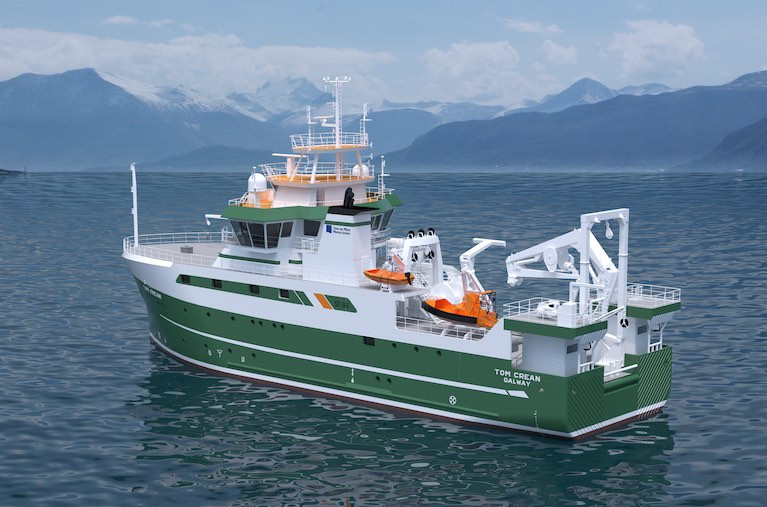
RV Tom Crean of 52.8m will be one of world's most advanced research vessels is to directly replace the smaller RV Celtic Voyager of 31.40m and of 23 years service having operated duties in more inshore waters.

While the larger fleetmate, RV Celtic Explorer of 65.5m dating to 2003 will be joined by the newbuild to carry out an extensive capability of marine research activities. They include vital fisheries data (incl. EU Common Fisheries Policy), Irish seabed mapping (INFOMAR) and oceanography and critical climate change related research given this year marks the start of the UN Decade of the Ocean (2021-2030) and its urgency.

The newbuild was commissioned by the Department of Agriculture, Food and the Marine with the approval of the Government of Ireland, to enable the State's national integrated marine plan, 'Harnessing Our Ocean Wealth' and the national Marine Research and Innovation Strategy.

Afloat can also reveal that RV Tom Crean will be around 1,900 gross registered tonnes, with the first block laid down on 4th November last year at the Spanish shipyard of Astilleros Armon Vigo S.A. So far, 19 out of 32 block sections constructed are in place, with September 2021 scheduled for starting a 'fitting-out' period of the semi-completed newbuild prior to the newbuild's commissioning around a year later.

The shipyard is working to a design of Norwegian naval architects, Skipsteknisk AS based in Ålesund which was awarded the work following a EU tender process. The design consultancy were also responsible for the RV Celtic Explorer which will be joined by RV Tom Crean in the M.I.'s homeport of Galway, strategically located on the western seaboard and with easy access to the North Atlantic Ocean.

Afloat contacted the Marine Institute since (their press release), for further details of the RV Tom Crean characteristics, in particular the all important aft work deck, where the primary action is to take place in water operations in depths down to 4,000m.

According to Aodhán FitzGerald, Research Vessel Manager of the MI, the RV Tom Crean will feature an articulated boom crane aft (6t@ 10m, 3T@ 15m), located on the aft-gantry. This will be largely used for loading science equipment and net and equipment handling offshore.

Mounted at the stern is a 10T A frame aft which can articulate through 170 degrees which is for deploying and recovering large science equipment such as remotely operated vehicle (ROV’s), towed sleds and for fishing operations.

The vessel also has a heave compensated CTD system (system for measuring water temperature, salinity and depth  and for collecting water samples) consisting of a deepwater winch and Frame to allow CTD operations in water depths down to 4000m.

Part of the equippment will be a regulation MOB boat on a dedicated davit and the facility to carry a 6.5m Rigid Inflatable tender on the port side.

Also at the aft deck is where the 'Holland 1' Work class ROV and the University of Limericks 'Etain' sub Atlantic ROV will be positioned. In addition up to 3 x 20’ (TEU) containers can be carried.

The newbuild has been engineered to endure increasing harsher conditions and the punishing weather systems encountered in the North-East Atlantic where deployments of RV Tom Crean on surveys spent up to 21 days duration.

In addition, RV Tom Crean will be able to operate in an ultra silent-mode, which is crucial to meet the stringent criteria of the ICES 209 noise standard for fisheries research purposes.

Of course all this broad-tasking can only be achieved with a team combining 12 crew and 14 scientists accommodated in the research vessel with associated laboratory facilities. In addition there will also be an on board hospital.

Published in RV Tom Crean

Dublin Bay

Dublin Bay on the east coast of Ireland stretches over seven kilometres, from Howth Head on its northern tip to Dalkey Island in the south. It's a place most Dubliners simply take for granted, and one of the capital's least visited places. But there's more going on out there than you'd imagine.

The biggest boating centre is at Dun Laoghaire Harbour on the Bay's south shore that is home to over 1,500 pleasure craft, four waterfront yacht clubs and Ireland's largest marina.

The bay is rather shallow with many sandbanks and rocky outcrops, and was notorious in the past for shipwrecks, especially when the wind was from the east. Until modern times, many ships and their passengers were lost along the treacherous coastline from Howth to Dun Laoghaire, less than a kilometre from shore.

The Bay is a C-shaped inlet of the Irish Sea and is about 10 kilometres wide along its north-south base, and 7 km in length to its apex at the centre of the city of Dublin; stretching from Howth Head in the north to Dalkey Point in the south. North Bull Island is situated in the northwest part of the bay, where one of two major inshore sandbanks lie, and features a 5 km long sandy beach, Dollymount Strand, fronting an internationally recognised wildfowl reserve. Many of the rivers of Dublin reach the Irish Sea at Dublin Bay: the River Liffey, with the River Dodder flow received less than 1 km inland, River Tolka, and various smaller rivers and streams.

Dublin Bay FAQs

There are approximately ten beaches and bathing spots around Dublin Bay: Dollymount Strand; Forty Foot Bathing Place; Half Moon bathing spot; Merrion Strand; Bull Wall; Sandycove Beach; Sandymount Strand; Seapoint; Shelley Banks; Sutton, Burrow Beach

There are slipways on the north side of Dublin Bay at Clontarf, Sutton and on the southside at Dun Laoghaire Harbour, and in Dalkey at Coliemore and Bulloch Harbours.

Dublin Bay is administered by a number of Government Departments, three local authorities and several statutory agencies. Dublin Port Company is in charge of navigation on the Bay.

Dublin Bay is approximately 70 sq kilometres or 7,000 hectares. The Bay is about 10 kilometres wide along its north-south base, and seven km in length east-west to its peak at the centre of the city of Dublin; stretching from Howth Head in the north to Dalkey Point in the south.

Dun Laoghaire Harbour on the southside of the Bay has an East and West Pier, each one kilometre long; this is one of the largest human-made harbours in the world. There also piers or walls at the entrance to the River Liffey at Dublin city known as the Great North and South Walls. Other harbours on the Bay include Bulloch Harbour and Coliemore Harbours both at Dalkey.

There are two marinas on Dublin Bay. Ireland's largest marina with over 800 berths is on the southern shore at Dun Laoghaire Harbour. The other is at Poolbeg Yacht and Boat Club on the River Liffey close to Dublin City.

Car and passenger Ferries operate from Dublin Port to the UK, Isle of Man and France. A passenger ferry operates from Dun Laoghaire Harbour to Howth as well as providing tourist voyages around the bay.

Dublin Bay has two Islands. Bull Island at Clontarf and Dalkey Island on the southern shore of the Bay.

The River Liffey flows through Dublin city and into the Bay. Its tributaries include the River Dodder, the River Poddle and the River Camac.

Dollymount, Burrow and Seapoint beaches

Approximately 1,500 boats from small dinghies to motorboats to ocean-going yachts. The vast majority, over 1,000, are moored at Dun Laoghaire Harbour which is Ireland's boating capital.

In 1981, UNESCO recognised the importance of Dublin Bay by designating North Bull Island as a Biosphere because of its rare and internationally important habitats and species of wildlife. To support sustainable development, UNESCO’s concept of a Biosphere has evolved to include not just areas of ecological value but also the areas around them and the communities that live and work within these areas. There have since been additional international and national designations, covering much of Dublin Bay, to ensure the protection of its water quality and biodiversity. To fulfil these broader management aims for the ecosystem, the Biosphere was expanded in 2015. The Biosphere now covers Dublin Bay, reflecting its significant environmental, economic, cultural and tourism importance, and extends to over 300km² to include the bay, the shore and nearby residential areas.

On the Southside at Dun Laoghaire, there is the National Yacht Club, Royal St. George Yacht Club, Royal Irish Yacht Club and Dun Laoghaire Motor Yacht Club as well as Dublin Bay Sailing Club. In the city centre, there is Poolbeg Yacht and Boat Club. On the Northside of Dublin, there is Clontarf Yacht and Boat Club and Sutton Dinghy Club. While not on Dublin Bay, Howth Yacht Club is the major north Dublin Sailing centre.

© Afloat 2020