Menu

Ireland's sailing, boating & maritime magazine

Dublin Bay Boating News and Information

Displaying items by tag: Excursion CalMac

#ScottishIsles – Caledonian MacBrayne’s (CalMac) ferry route to the Isle of Arran, dubbed Scotland in miniature, and to the Mull of Kintyre, provides a ‘gateway’ particularly for Irish visitors, given the proximity of the south-west region, writes Jehan Ashmore.

Among the Forth of Clyde services is the popular Ardrossan-Brodick (Arran) route and the added option of continued exploration further west with the Ardrossan-Campbeltown (Mull of Kintyre) service. Either route, presents an introduction to the wonders and wilderness of these areas and more of the Western Isles. CalMac have an extensive car ferry route network and multiple-destination tickets ideal for island-hopping.

Travel as a motorist or as a foot-passenger by beginning at Ardrossan on the Ayrshire coast which is easily accessible by road or bus (via Ayr) having taken sailings from either North Channel ports to those on Loch Ryan, Scotland. There’s a choice between Belfast-Cairnryan, Loch Ryan Port (Stena Line) and Larne-Cairnryan (P&O Ferries) services.

Arran offers a wondrous mix of mountains, forests, lochs, sandy beaches and a whisky distillery. All of this can be reached by taking the Ardrossan-Brodick ferry of only 55 minutes duration. The year-round route’s mainstay, Caledonian Isles (1993/5,221grt) in the high-season is supported by additional capacity from Isle of Arran (1984/3,296grt). In addition the first drive through roll-on roll-off ferry built for CalMac, sails the seasonal Mull of Kintyre route that runs up to late September.

Alternatively, the short cut from Arran back to the mainland, albeit missing out on the Kintyre Peninsula, is by taking from the north of the island the short-hop on board Loch Tarbert (1992/211gt).This smaller ferry plies between Lochranza and Claonaig, that lies south of Tarbert. This option, also requires a drive northwards before heading south to Glasgow and returning to ferryports on Loch Ryan.

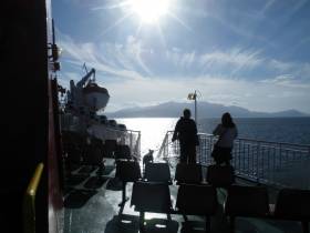
Facilities on board the Ardrossan serving ferries include a ‘Mariners’ restaurant with an emphasis on locally produced food, a giftshop, bar and lounges with forward facing views. On that note, the open deck spaces to soak up these views, unlike the cross-channel ferries, was a most welcomed feature.

The short passage from Ardrossan to Brodick, Arran across the Forth of Clyde presents views of both mainland and that of the looming dominance of the island’s mountain, Goat Fell. The peak of 874m / 2,866ft towers above Brodick Bay.

The Fair Trade island's main town Brodick, has hotels, cafe and gift shops lining the waterfront and nearby sandy beach. On a recent visit, offshore, day-tripper yachts were moored and were joined by an evening arrival of an impressive private three-masted schooner. The yacht took advantage of the sheltered anchorage to overnight in the bay. In the distance thick forests surround Brodick Castle & Gardens, an 800 year-old highland estate, the UK’s only island country park which is open to the public.

The Mull of Kintyre route, Ardrossan-Campbetown, takes only 2 hours and 30 minutes and on this connection (saving on distance, time and fuel) affords further views off the south coast of Arran. Noting on Saturdays only and in the reverse direction, the ferry departs from Campbeltown to firstly make an en route call to Brodick, Arran before continuing the crossing to Ardrossan.

The approaches to Campbeltown begins with another imposing feature, the steep sided Davaar Island at the entrance to an inlet leading to the port. The harbour is home to a mix of fishing fleet and leisure boats at the marina located conveniently in the centre of the town.

Berthed at the marina, was a ‘passenger-only’ RIB ferry of operator Kintyre Express, which offers an alternative direct service to and from Northern Ireland, on the route out of Ballycastle, Co. Antrim.

It was from the Kintyre coastline could be seen south the ‘North’. In the other direction while taking the Glasgow bound bus were more isles: Gigha, Islay and Jura. An en route stop was made at the stunningly spectacular inland coastal location of Inveraray, on Lough Fyne in which Afloat.ie will have a further report.

Published in Ferry

Dublin Bay

Dublin Bay on the east coast of Ireland stretches over seven kilometres, from Howth Head on its northern tip to Dalkey Island in the south. It's a place most Dubliners simply take for granted, and one of the capital's least visited places. But there's more going on out there than you'd imagine.

The biggest boating centre is at Dun Laoghaire Harbour on the Bay's south shore that is home to over 1,500 pleasure craft, four waterfront yacht clubs and Ireland's largest marina.

The bay is rather shallow with many sandbanks and rocky outcrops, and was notorious in the past for shipwrecks, especially when the wind was from the east. Until modern times, many ships and their passengers were lost along the treacherous coastline from Howth to Dun Laoghaire, less than a kilometre from shore.

The Bay is a C-shaped inlet of the Irish Sea and is about 10 kilometres wide along its north-south base, and 7 km in length to its apex at the centre of the city of Dublin; stretching from Howth Head in the north to Dalkey Point in the south. North Bull Island is situated in the northwest part of the bay, where one of two major inshore sandbanks lie, and features a 5 km long sandy beach, Dollymount Strand, fronting an internationally recognised wildfowl reserve. Many of the rivers of Dublin reach the Irish Sea at Dublin Bay: the River Liffey, with the River Dodder flow received less than 1 km inland, River Tolka, and various smaller rivers and streams.

Dublin Bay FAQs

There are approximately ten beaches and bathing spots around Dublin Bay: Dollymount Strand; Forty Foot Bathing Place; Half Moon bathing spot; Merrion Strand; Bull Wall; Sandycove Beach; Sandymount Strand; Seapoint; Shelley Banks; Sutton, Burrow Beach

There are slipways on the north side of Dublin Bay at Clontarf, Sutton and on the southside at Dun Laoghaire Harbour, and in Dalkey at Coliemore and Bulloch Harbours.

Dublin Bay is administered by a number of Government Departments, three local authorities and several statutory agencies. Dublin Port Company is in charge of navigation on the Bay.

Dublin Bay is approximately 70 sq kilometres or 7,000 hectares. The Bay is about 10 kilometres wide along its north-south base, and seven km in length east-west to its peak at the centre of the city of Dublin; stretching from Howth Head in the north to Dalkey Point in the south.

Dun Laoghaire Harbour on the southside of the Bay has an East and West Pier, each one kilometre long; this is one of the largest human-made harbours in the world. There also piers or walls at the entrance to the River Liffey at Dublin city known as the Great North and South Walls. Other harbours on the Bay include Bulloch Harbour and Coliemore Harbours both at Dalkey.

There are two marinas on Dublin Bay. Ireland's largest marina with over 800 berths is on the southern shore at Dun Laoghaire Harbour. The other is at Poolbeg Yacht and Boat Club on the River Liffey close to Dublin City.

Car and passenger Ferries operate from Dublin Port to the UK, Isle of Man and France. A passenger ferry operates from Dun Laoghaire Harbour to Howth as well as providing tourist voyages around the bay.

Dublin Bay has two Islands. Bull Island at Clontarf and Dalkey Island on the southern shore of the Bay.

The River Liffey flows through Dublin city and into the Bay. Its tributaries include the River Dodder, the River Poddle and the River Camac.

Dollymount, Burrow and Seapoint beaches

Approximately 1,500 boats from small dinghies to motorboats to ocean-going yachts. The vast majority, over 1,000, are moored at Dun Laoghaire Harbour which is Ireland's boating capital.

In 1981, UNESCO recognised the importance of Dublin Bay by designating North Bull Island as a Biosphere because of its rare and internationally important habitats and species of wildlife. To support sustainable development, UNESCO’s concept of a Biosphere has evolved to include not just areas of ecological value but also the areas around them and the communities that live and work within these areas. There have since been additional international and national designations, covering much of Dublin Bay, to ensure the protection of its water quality and biodiversity. To fulfil these broader management aims for the ecosystem, the Biosphere was expanded in 2015. The Biosphere now covers Dublin Bay, reflecting its significant environmental, economic, cultural and tourism importance, and extends to over 300km² to include the bay, the shore and nearby residential areas.

On the Southside at Dun Laoghaire, there is the National Yacht Club, Royal St. George Yacht Club, Royal Irish Yacht Club and Dun Laoghaire Motor Yacht Club as well as Dublin Bay Sailing Club. In the city centre, there is Poolbeg Yacht and Boat Club. On the Northside of Dublin, there is Clontarf Yacht and Boat Club and Sutton Dinghy Club. While not on Dublin Bay, Howth Yacht Club is the major north Dublin Sailing centre.

© Afloat 2020