Displaying items by tag: Ferox Trout
New Research on Ferox Trout Highlights Its Importance to Lough Corrib & Lough Mask
A newly published research paper co-authored by experts in Ireland highlights the importance of ferox trout to the fisheries of Lough Corrib and Lough Mask.
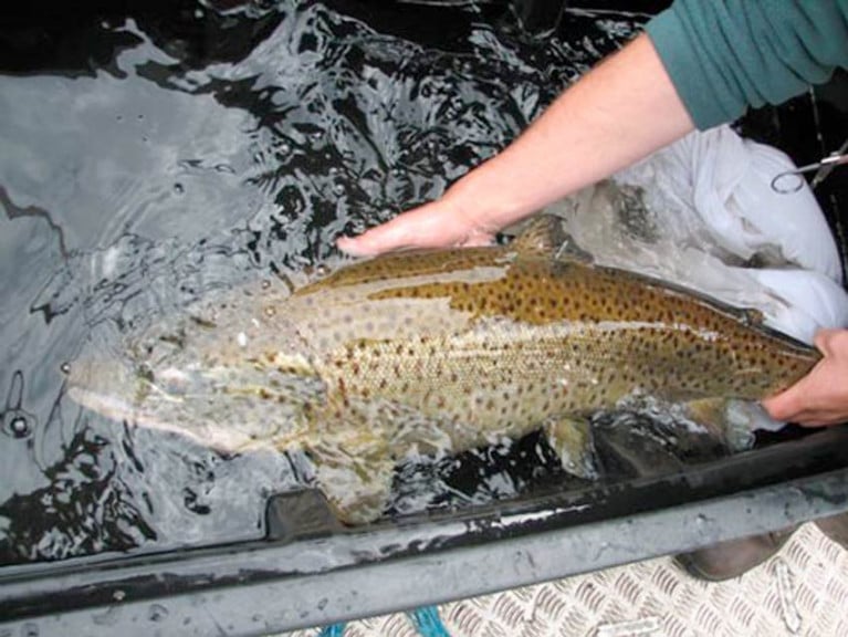
Ferox trout are highly prized by trophy anglers, and Loughs Corrib and Mask have recorded the majority of Irish specimens since angling records began in the 1950s.
The large, long-lived, fish-eating trout are normally found in deep lakes and are believed to be genetically distinct from normal brown trout, having evolved after the last Ice Age 12,000 years ago.
Little was known about the spawning location of Irish ferox trout compared to normal brown trout, and a radio tracking study was initiated in both catchments in 2005.
Local anglers and Inland Fisheries Ireland (IFI) staff helped catch large ferox trout on both lakes in order to insert radio tags.
The fish were released after tagging and then tracked with help from the Irish Air Corps helicopter unit and by walking spawning streams with a radio tracking antenna to determine in which streams ferox spawned.
Scientists from Inland Fisheries Ireland worked with colleagues at the Norwegian Institute for Nature Research on the data collected in this study.
Results from radio tracking showed that the majority (92%) of ferox trout tagged in Lough Corrib spawned in a single spawning stream, the Cong River, while the majority (76%) of ferox trout tagged in Lough Mask spawned in the Cong canal and Cong River.
These results, as published in the Journal of Fish Biology, indicate that these streams are most likely the principle spawning locations of ferox trout in both lakes.
Dr Paddy Gargan, senior research officer at Inland Fisheries Ireland and lead author on the publication, said: “The occurrence of ferox trout predominantly in single spawning rivers in both catchments highlights the vulnerability of the ferox populations with estimates of their population size thought to be small”.
IFI’s head of research Dr Cathal Gallagher welcomed the findings and said: “It was important that conservation measures, based on this research, have been introduced in the Corrib and Mask catchments continue to protect ferox trout.
“These conservation measures have reduced the number of ferox trout being killed and claimed as specimens and support the conservation of this unique trout.”
Two Anglers Plead Guilty To Illegal Fishing Methods On Cong River During Annual Closed Season

Two anglers recently appeared in court on charges relating to illegal fishing methods on the Cong River and fishing during the closed season.
On Thursday 23 May, Mindaugas Jenkus of Claremorris, Co Mayo and Dalius Bureninas of Birr, Co Offaly appeared in front of Judge Mary Fahy at Clifden District Court in respect of breaches of fisheries legislation on the Cong River which occurred on 9 September 2018.
Both defendants represented themselves and pleaded guilty to strokehauling (using a weighted instrument or device with a rod and line or otherwise to foul-hook fish) and fishing out of season on the Cong River.
Bureninas also pleaded guilty to a further charge of obstruction under Section 301 (7) of the Fisheries (Consolidation) Act 1959.
Fisheries officer Paul Reynolds outlined the facts of the case to the court, while assistant fisheries inspector Barry Kelly also told the court that the Cong River was a very important salmonid fishery with has a large run of Atlantic salmon and a good stock of brown trout.
It is also of particular conservation interest in relation to ferox trout, for which the river is renowned.
The Cong River is one of the main tributaries of Lough Corrib, and is one of the most important salmon rivers in the west of Ireland
Fisheries inspector Pat Gorman stated that these offences were very serious due to the conservation status of the Cong River, when asked his opinion by Judge Fahy.
The judge commented on how serious a matter these offences were and referred to Bureninas giving a false name and address when lawfully demanded. She also noted that Mr Jenkus had a recent conviction for a similar fisheries offence.
Judge Fahy stated that if both defendants paid costs of €600 each to the court at a sitting of Clifden District Court on 26 September, she may deal with the matter by way of a somewhat reduced fine.
She also warned both men to be on their best behaviour and not to come to the attention of Inland Fisheries Ireland (IFI) again as there was a risk of a custodial sentence being imposed.
“The Cong River is one of the main tributaries of Lough Corrib, is one of the most important salmon rivers in the west of Ireland and provides habitat for a very unique salmonid sub-species, ferox trout,” said IFI chief executive Dr Ciaran Byrne when commenting on the case.
“The Cong River is closed to angling during September as a conservation measure relating to both Atlantic salmon and ferox trout. The river attracts many anglers and tourists annually to fish for these unique wild salmonid species.”


