Menu

Ireland's sailing, boating & maritime magazine

Dublin Bay Boating News and Information

Displaying items by tag: Fish Revolution

#PublicLecture - 'The Little Ice Age and the North Atlantic Fish Revolution' is the title of a public lecture delivered by Prof Poul Holm and Dr Francis Ludlow of Trinity College Dublin at lunchtime this Wednesday 13 April at the Marine Institute headquarters in Oranmore, Co Galway.

Holm is Professor of Environmental History at the School of Histories and Humanities in TCD. In 2015 he was awarded an Advanced Grant of €2.5 million by the European Research Council. In the next five years he and his team will explore the North Atlantic 'fish revolution' circa 1400-1700 AD.

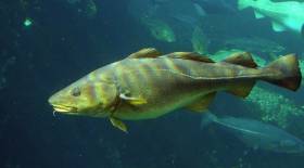
In 1497, John Cabot returned to Bristol from a voyage across the North Atlantic. He told of waters so thick with fish that they could be lifted straight on board in baskets. Within a few years of this journey, fishermen from all over Western Europe made the journey across. This was the beginning of the 'fish revolution' of the early-modern world.

The fish revolution was one of the first examples of the disrupting effects of globalisation and climate change. Fish was a high-priced, limited resource in the Late Middle Ages. The Grand Banks fishery offered abundant high-quality low-priced catches to the European market. At the same time climate worsened as the Little Ice Age drove down sea temperatures and changed marine ecosystems.

The consequences were dire for fishermen along the coasts from the Irish Sea right up to northern Norway. As they caught less cod locally at higher prices, the fishermen had the choice of migrating across the ocean or give up fishing. Many fishing settlements were deserted as inhabitants took to the road to seek casual work in agriculture or towns.

Kings and high politics were similarly affected by the fish revolution. The new resource held strategic importance for all major western European powers, such as Spain, Britain and France. North Atlantic warfare was about fish as well as about gold.

In recent years we have all been affected by the impact of global change. We want to know if we can untangle the drivers of prices and temperatures to explain the causes of the fish revolution, and we want to know how people understood and responded to the challenges of globalisation and climate change. The lecture posits that perhaps the fish revolution of the Middle Ages is a distant mirror for today.

All are welcome to the event at the Marine Institute Auditorium this Wednesday at 12 noon.

Published in Fishing

Dublin Bay

Dublin Bay on the east coast of Ireland stretches over seven kilometres, from Howth Head on its northern tip to Dalkey Island in the south. It's a place most Dubliners simply take for granted, and one of the capital's least visited places. But there's more going on out there than you'd imagine.

The biggest boating centre is at Dun Laoghaire Harbour on the Bay's south shore that is home to over 1,500 pleasure craft, four waterfront yacht clubs and Ireland's largest marina.

The bay is rather shallow with many sandbanks and rocky outcrops, and was notorious in the past for shipwrecks, especially when the wind was from the east. Until modern times, many ships and their passengers were lost along the treacherous coastline from Howth to Dun Laoghaire, less than a kilometre from shore.

The Bay is a C-shaped inlet of the Irish Sea and is about 10 kilometres wide along its north-south base, and 7 km in length to its apex at the centre of the city of Dublin; stretching from Howth Head in the north to Dalkey Point in the south. North Bull Island is situated in the northwest part of the bay, where one of two major inshore sandbanks lie, and features a 5 km long sandy beach, Dollymount Strand, fronting an internationally recognised wildfowl reserve. Many of the rivers of Dublin reach the Irish Sea at Dublin Bay: the River Liffey, with the River Dodder flow received less than 1 km inland, River Tolka, and various smaller rivers and streams.

Dublin Bay FAQs

There are approximately ten beaches and bathing spots around Dublin Bay: Dollymount Strand; Forty Foot Bathing Place; Half Moon bathing spot; Merrion Strand; Bull Wall; Sandycove Beach; Sandymount Strand; Seapoint; Shelley Banks; Sutton, Burrow Beach

There are slipways on the north side of Dublin Bay at Clontarf, Sutton and on the southside at Dun Laoghaire Harbour, and in Dalkey at Coliemore and Bulloch Harbours.

Dublin Bay is administered by a number of Government Departments, three local authorities and several statutory agencies. Dublin Port Company is in charge of navigation on the Bay.

Dublin Bay is approximately 70 sq kilometres or 7,000 hectares. The Bay is about 10 kilometres wide along its north-south base, and seven km in length east-west to its peak at the centre of the city of Dublin; stretching from Howth Head in the north to Dalkey Point in the south.

Dun Laoghaire Harbour on the southside of the Bay has an East and West Pier, each one kilometre long; this is one of the largest human-made harbours in the world. There also piers or walls at the entrance to the River Liffey at Dublin city known as the Great North and South Walls. Other harbours on the Bay include Bulloch Harbour and Coliemore Harbours both at Dalkey.

There are two marinas on Dublin Bay. Ireland's largest marina with over 800 berths is on the southern shore at Dun Laoghaire Harbour. The other is at Poolbeg Yacht and Boat Club on the River Liffey close to Dublin City.

Car and passenger Ferries operate from Dublin Port to the UK, Isle of Man and France. A passenger ferry operates from Dun Laoghaire Harbour to Howth as well as providing tourist voyages around the bay.

Dublin Bay has two Islands. Bull Island at Clontarf and Dalkey Island on the southern shore of the Bay.

The River Liffey flows through Dublin city and into the Bay. Its tributaries include the River Dodder, the River Poddle and the River Camac.

Dollymount, Burrow and Seapoint beaches

Approximately 1,500 boats from small dinghies to motorboats to ocean-going yachts. The vast majority, over 1,000, are moored at Dun Laoghaire Harbour which is Ireland's boating capital.

In 1981, UNESCO recognised the importance of Dublin Bay by designating North Bull Island as a Biosphere because of its rare and internationally important habitats and species of wildlife. To support sustainable development, UNESCO’s concept of a Biosphere has evolved to include not just areas of ecological value but also the areas around them and the communities that live and work within these areas. There have since been additional international and national designations, covering much of Dublin Bay, to ensure the protection of its water quality and biodiversity. To fulfil these broader management aims for the ecosystem, the Biosphere was expanded in 2015. The Biosphere now covers Dublin Bay, reflecting its significant environmental, economic, cultural and tourism importance, and extends to over 300km² to include the bay, the shore and nearby residential areas.

On the Southside at Dun Laoghaire, there is the National Yacht Club, Royal St. George Yacht Club, Royal Irish Yacht Club and Dun Laoghaire Motor Yacht Club as well as Dublin Bay Sailing Club. In the city centre, there is Poolbeg Yacht and Boat Club. On the Northside of Dublin, there is Clontarf Yacht and Boat Club and Sutton Dinghy Club. While not on Dublin Bay, Howth Yacht Club is the major north Dublin Sailing centre.

© Afloat 2020