Menu

Ireland's sailing, boating & maritime magazine

Dublin Bay Boating News and Information

Displaying items by tag: Floods

Corrib Head of the River, the rowing event scheduled for Galway on Saturday, has been cancelled because the flow of the river is too strong to safely hold the event. This means that all seven heads which should have been held this year have been cancelled.

 Meanwhile, Rowing Ireland has announced that it will limit access to the National Rowing Centre to high the Olympic training squad, coaches and “essential staff”.

 Rowing Ireland says that no one outside this group will be granted access until April 5th, when the decision will be reviewed.

 Development camps, trials for under-23 and juniors and club and schools activities will not be allowed.


Published in Rowing

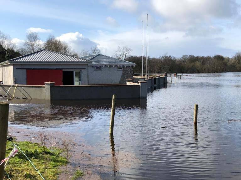
Rowing clubs along the Shannon have been badly affected by high water levels. Carrick on Shannon and Athlone have both been hit, while Castleconnell is flooded. This came despite pumping. The gym equipment had been moved out and the boats are stored higher up the bank.

This ESB at Ardnacrusha stated: “Due to heavy rainfall in the catchment we will be increasing discharge from Parteen Weir. You are being notified that water is about to be discharged above 325 m3/sec. This will result in flooding of roads, land and may affect property. You are advised to be aware of increased flows in the river as a result of this water discharge. Further increases in discharge may be required. Approx. 400 m3/sec will be discharged.”

Published in Rowing

#Floods - Fears that the Shannon and other rivers have no more capacity to absorb floodwaters are on the increase, as State agencies fighting the tides met in Dublin yesterday.

According to The Irish Times, the National Emergency Co-ordination Group was warned that with more heavy rain due over the next few days, Ireland's rivers have literally reached breaking point as waterlogged lands drain into our inland waterways.

But Environment Minister Phil Hogan said the present situation did not constitute a national emergency, in spite of some of the worst flooding ever experienced in Limerick and Cork over recent days.

The Irish Times has more on the story HERE.

Published in News Update
Tagged under

#Rowing: The Head of the Shannon, set for this Saturday, has fallen to the bad weather. The event, organised by Carrick-on-Shannon Rowing Club, cannot be held because the river is in flood. The weather forecast is for more high winds.

Irish rowing has had no on-the-water competitive events this year so far, as the St Michael’s, Kerry and Sligo heads have already been cancelled, though St Michael’s say they hope to stage their event on February 22nd.

The Dublin Metropolitan Regatta will now take place on May 17th, moving from its slot in June to fill the space left by the cancelled Queen’s University Regatta.

Published in Rowing

Dublin Bay

Dublin Bay on the east coast of Ireland stretches over seven kilometres, from Howth Head on its northern tip to Dalkey Island in the south. It's a place most Dubliners simply take for granted, and one of the capital's least visited places. But there's more going on out there than you'd imagine.

The biggest boating centre is at Dun Laoghaire Harbour on the Bay's south shore that is home to over 1,500 pleasure craft, four waterfront yacht clubs and Ireland's largest marina.

The bay is rather shallow with many sandbanks and rocky outcrops, and was notorious in the past for shipwrecks, especially when the wind was from the east. Until modern times, many ships and their passengers were lost along the treacherous coastline from Howth to Dun Laoghaire, less than a kilometre from shore.

The Bay is a C-shaped inlet of the Irish Sea and is about 10 kilometres wide along its north-south base, and 7 km in length to its apex at the centre of the city of Dublin; stretching from Howth Head in the north to Dalkey Point in the south. North Bull Island is situated in the northwest part of the bay, where one of two major inshore sandbanks lie, and features a 5 km long sandy beach, Dollymount Strand, fronting an internationally recognised wildfowl reserve. Many of the rivers of Dublin reach the Irish Sea at Dublin Bay: the River Liffey, with the River Dodder flow received less than 1 km inland, River Tolka, and various smaller rivers and streams.

Dublin Bay FAQs

There are approximately ten beaches and bathing spots around Dublin Bay: Dollymount Strand; Forty Foot Bathing Place; Half Moon bathing spot; Merrion Strand; Bull Wall; Sandycove Beach; Sandymount Strand; Seapoint; Shelley Banks; Sutton, Burrow Beach

There are slipways on the north side of Dublin Bay at Clontarf, Sutton and on the southside at Dun Laoghaire Harbour, and in Dalkey at Coliemore and Bulloch Harbours.

Dublin Bay is administered by a number of Government Departments, three local authorities and several statutory agencies. Dublin Port Company is in charge of navigation on the Bay.

Dublin Bay is approximately 70 sq kilometres or 7,000 hectares. The Bay is about 10 kilometres wide along its north-south base, and seven km in length east-west to its peak at the centre of the city of Dublin; stretching from Howth Head in the north to Dalkey Point in the south.

Dun Laoghaire Harbour on the southside of the Bay has an East and West Pier, each one kilometre long; this is one of the largest human-made harbours in the world. There also piers or walls at the entrance to the River Liffey at Dublin city known as the Great North and South Walls. Other harbours on the Bay include Bulloch Harbour and Coliemore Harbours both at Dalkey.

There are two marinas on Dublin Bay. Ireland's largest marina with over 800 berths is on the southern shore at Dun Laoghaire Harbour. The other is at Poolbeg Yacht and Boat Club on the River Liffey close to Dublin City.

Car and passenger Ferries operate from Dublin Port to the UK, Isle of Man and France. A passenger ferry operates from Dun Laoghaire Harbour to Howth as well as providing tourist voyages around the bay.

Dublin Bay has two Islands. Bull Island at Clontarf and Dalkey Island on the southern shore of the Bay.

The River Liffey flows through Dublin city and into the Bay. Its tributaries include the River Dodder, the River Poddle and the River Camac.

Dollymount, Burrow and Seapoint beaches

Approximately 1,500 boats from small dinghies to motorboats to ocean-going yachts. The vast majority, over 1,000, are moored at Dun Laoghaire Harbour which is Ireland's boating capital.

In 1981, UNESCO recognised the importance of Dublin Bay by designating North Bull Island as a Biosphere because of its rare and internationally important habitats and species of wildlife. To support sustainable development, UNESCO’s concept of a Biosphere has evolved to include not just areas of ecological value but also the areas around them and the communities that live and work within these areas. There have since been additional international and national designations, covering much of Dublin Bay, to ensure the protection of its water quality and biodiversity. To fulfil these broader management aims for the ecosystem, the Biosphere was expanded in 2015. The Biosphere now covers Dublin Bay, reflecting its significant environmental, economic, cultural and tourism importance, and extends to over 300km² to include the bay, the shore and nearby residential areas.

On the Southside at Dun Laoghaire, there is the National Yacht Club, Royal St. George Yacht Club, Royal Irish Yacht Club and Dun Laoghaire Motor Yacht Club as well as Dublin Bay Sailing Club. In the city centre, there is Poolbeg Yacht and Boat Club. On the Northside of Dublin, there is Clontarf Yacht and Boat Club and Sutton Dinghy Club. While not on Dublin Bay, Howth Yacht Club is the major north Dublin Sailing centre.

© Afloat 2020