Displaying items by tag: Free Tours
Free Heritage Tours of National Maritime Museum of Ireland in Dun Laoghaire's Old Mariners' Church
Free self-guided tours of the National Maritime Museum of Ireland (NMMI) in Dun Laoghaire form part of the annual 'Summer of Heritage' programme run by the Heritage Office of Dún Laoghaire-Rathdown County Council, writes Jehan Ashmore
The Maritime Museum located aptly near the coast in the former Mariners Church which itself is one of a few custom built places of worship for seafarers remaining intact in the world today. Opposite of the museum in stark architectural contrast is the dlr Lexicon, flagship library of the council and a landmark almost opposite of the the harbour's East Pier on Dublin Bay.
Both venues are easily accesible from the nearby DART station and several bus services. There is also local car-parking at the Pavilion complex that neighbours the Lexicon.
Museum Tours of Maritime Heritage
This year's tours of the NMMI will be somewhat different due to the health and welfare of visitors and staff which is a primary concern for all and so the museum have made a few changes to accommodate the heritage-held programme.
Visitors will be able to experience a voyage through enthralling stories of discovery, heroism, war and disasters at sea. In addition to see nature and art inspired by the sea and also hear about innovative Irish inventions, scientists and local mariners which collectively form a treasure trove of matters maritime.
The tours are held every Monday and Wednesday until Wednesday, September 9th.
Each tour will be staggered apart, with one beginning at 11:00am and the other tour taking place at 11:30am.
Limited Tickets (click the NMMI website / Eventbrite here)
There will be a limit of six people per tour.
Noting the musuem will only have an allocation of 14 places per day and the NMMI advise if you know you are not going to be able to make it, please cancel your booking and let someone else take your place.
Covid-19
As of 10 August in a directive issued from the Department of Health, face coverings are mandatory in Museums and some other public spaces. Please ensure you have a face mask before entering the Museum to be compliant.
Patrons of the self-guided tours will be requested to strictly adhere to observing social distancing with people outside their household.
Brief background on Old Mariners Church
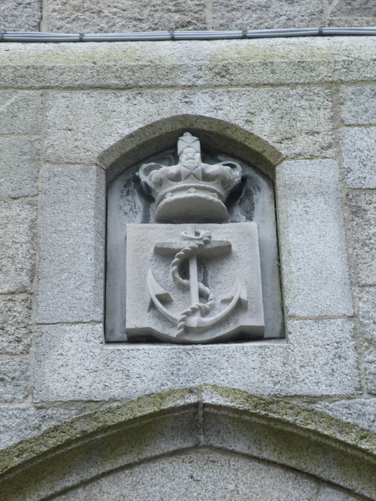
The museum’s greatest artefact is probably the former church itself as it is one of a few custom built places of worship for seafarers remaining intact in the world.
The Old Mariners' Church of the Church of Ireland was erected in 1836, to the design of Joseph Welland, which according to the publication ' New Life, for churches in Ireland' (2012) was for the benefit of many a sailor, who were based in the then harbour town named Kingstown where British Navy vessels used. All naval crew were obliged to attend Devine Service. Also according to Mary Hamilton, writing in th early 1900's, describes Welsh and Cornish fishing crew along with the local congregation, crowding the church, which, with its spacious galleries, could accommodate up to 1,000 worshippers.
The church closed in 1970 including the school building and residence which was sold off separately, however the former place of worship was leased from the Representative Church Body of the Church of Ireland to the Maritime Institute of Ireland (M.I.I.) which was founded in 1941 and also led to the formation of the NMMI.
Four years laters in 1974 the M.I.I. opened using the old church (having relocated from within the harbour) to the newly reconfigured and refurbished building that became their headquarters and museum albeit as the book describes for a 'peppercorn' rent. The building in more recent times was transferred to the museum.
The museum was open to its members and public alike over the decades until closing temporaily during the mid-2000's due to a deteriorating state of the old church building both outside and internally. Such conditions can be personally attested having observed with dismay water ingress near the pulpit and pigeons flying inside!
After securing government funding during the Celtic Tiger era this enabled an extensive refurbishment that ultimately led to the NMMI officially reopening on 5 June, 2012 by President Michael D. Higgins, patron of the museum from where that day the above photo was taken and published in the book by the Ulster Historic Churches Trust.
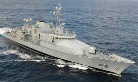
#navy - LÉ Niamh an offshore patrol vessel of the Naval Service is in the Port of Galway this week and is offering the public guided tours.
The OPV writes GalwayDaily will be alongside Galway this today and Friday, with the crew taking members of the public of the navy patrol ship between 1pm and 5pm.
LÉ Niamh is the second Róisín class ship built (Appledore, UK) for the Naval Service and to the same long (78.8m) design of older leadship that optimises her performance in rough Irish waters.
For more click here including a career drive to rise recruitment click this link for further information.


