Menu

Ireland's sailing, boating & maritime magazine

Dublin Bay Boating News and Information

Displaying items by tag: HMS Endurance

#ShackletonShips - The Ross Sea announced as the World’s largest marine park in the Antarctic is where ice patrol survey ship HMS Endurance nearly sank in the south Atlantic in 2008. Since then the ship has remained laid up, however in recent months she was scrapped, writes Jehan Ashmore.

HMS Endurance (A171) a former Royal Navy vessel based in the polar seas was named in honour of Sir Ernest Shackleton’s original expedition sail and steam ship Endurance.

The three-masted barquentine, Endurance was crushed by pack ice and sunk more than a century ago in late 1915. The incident took place during the Imperial Trans-Antarctic expedition of 1914-1918 led by the Irish born polar explorer. A 15ft model of the ship is on display in the Athy Heritage Museum, Co. Kildare and more recently a statue of Shackleton was unveiled. 

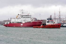
The 1995 built HMS Endurance had a near floundering incident in December 2008 while off Chile. The 5,129 gross tonnage vessel suffered flooding of her engine room that nearly sank her, following an error during routine maintenance on a sea suction strainer.

The damage was so severe that HMS Endurance was transported by semi-submersible ship to the UK, firstly Dartmouth and then Portsmouth  Naval Base. It was deemed far too expensive to carry out repairs and she was sold for scrap in 2013, however since Afloat’s coverage almost three years ago, the towage of the vessel only took place in June when bound for breakers in Turkey.

She had been employed as a hydrographic and support vessel for British Antarctic Survey (BAS), which is responsible for the UK's national scientific activities in Antarctica. A £150m newbuild RRS Sir David Attenborough currently under construction will join her fleetmates as outlined below. 

HMS Endurance was originally built as MV Polar Circle for Norwegians in 1990, then chartered to the Royal Navy and purchased. The navy equipped the vessel with Lynx helicopters as BAS aircraft cannot reach certain locations in the vast polar expanse.

Currently, the Royal Navy’s presence in these polar waters and the South Atlantic is tasked to HMS Protector (A173). Likewise of her predecessor, she operates along with BAS ships.

They are the civilian-manned polar research vessels, RRS Ernest Shackleton and RRS James Clarke Ross. The naming of the ship honours that of the British explorer who in 1841 visited the area (Ross Sea) located in southern Antarctica.

Published in Marine Science

#ShackletonShips – With attention focused on job losses at BAE Systems shipyards in Scotland and Portsmouth which is to cease shipbuilding in 2014, the Royal Navy base is also home to the former Antarctic ice patrol survey vessel, HMS Endurance, writes Jehan Ashmore.

As previously reported, the fate of HMS Endurance, which was named in honour of the 'original' Endurance which sank after trapped in ice during Sir Ernest Shackleton's Imperial Trans-Antarctic expedition of 1914-1918, and according to Ships Monthly is now likely to be scrapped.

HMS Endurance, albeit not built at Portsmouth's historic shipyard that notably launched King Henry VIII's Mary Rose (see new museum) more than 500 years ago, also suffered a serious incident having nearly foundered off Chile in 1991. She was towed to the UK but was never repaired.

As previously reported on Afloat.ie, there are two other vessels directly named in honouring the famed Irish-born polar explorer.

Firstly is the 1995 built RRS Sir Ernest Shackleton which was originally MV Polar Queen built for Rieber Shipping of Bergen.

Ships Monthly also reports that the Norwegian company recently sold sister MV Polar Protector (A173) to the UK Ministry of Defence for £51m as the current Royal Navy patrol and survey vessel for the South Atlantic and Antarctic.

The second vessel is the Dublin Port Company tug Shackleton named in 2010.


Published in Coastal Notes

Dublin Bay

Dublin Bay on the east coast of Ireland stretches over seven kilometres, from Howth Head on its northern tip to Dalkey Island in the south. It's a place most Dubliners simply take for granted, and one of the capital's least visited places. But there's more going on out there than you'd imagine.

The biggest boating centre is at Dun Laoghaire Harbour on the Bay's south shore that is home to over 1,500 pleasure craft, four waterfront yacht clubs and Ireland's largest marina.

The bay is rather shallow with many sandbanks and rocky outcrops, and was notorious in the past for shipwrecks, especially when the wind was from the east. Until modern times, many ships and their passengers were lost along the treacherous coastline from Howth to Dun Laoghaire, less than a kilometre from shore.

The Bay is a C-shaped inlet of the Irish Sea and is about 10 kilometres wide along its north-south base, and 7 km in length to its apex at the centre of the city of Dublin; stretching from Howth Head in the north to Dalkey Point in the south. North Bull Island is situated in the northwest part of the bay, where one of two major inshore sandbanks lie, and features a 5 km long sandy beach, Dollymount Strand, fronting an internationally recognised wildfowl reserve. Many of the rivers of Dublin reach the Irish Sea at Dublin Bay: the River Liffey, with the River Dodder flow received less than 1 km inland, River Tolka, and various smaller rivers and streams.

Dublin Bay FAQs

There are approximately ten beaches and bathing spots around Dublin Bay: Dollymount Strand; Forty Foot Bathing Place; Half Moon bathing spot; Merrion Strand; Bull Wall; Sandycove Beach; Sandymount Strand; Seapoint; Shelley Banks; Sutton, Burrow Beach

There are slipways on the north side of Dublin Bay at Clontarf, Sutton and on the southside at Dun Laoghaire Harbour, and in Dalkey at Coliemore and Bulloch Harbours.

Dublin Bay is administered by a number of Government Departments, three local authorities and several statutory agencies. Dublin Port Company is in charge of navigation on the Bay.

Dublin Bay is approximately 70 sq kilometres or 7,000 hectares. The Bay is about 10 kilometres wide along its north-south base, and seven km in length east-west to its peak at the centre of the city of Dublin; stretching from Howth Head in the north to Dalkey Point in the south.

Dun Laoghaire Harbour on the southside of the Bay has an East and West Pier, each one kilometre long; this is one of the largest human-made harbours in the world. There also piers or walls at the entrance to the River Liffey at Dublin city known as the Great North and South Walls. Other harbours on the Bay include Bulloch Harbour and Coliemore Harbours both at Dalkey.

There are two marinas on Dublin Bay. Ireland's largest marina with over 800 berths is on the southern shore at Dun Laoghaire Harbour. The other is at Poolbeg Yacht and Boat Club on the River Liffey close to Dublin City.

Car and passenger Ferries operate from Dublin Port to the UK, Isle of Man and France. A passenger ferry operates from Dun Laoghaire Harbour to Howth as well as providing tourist voyages around the bay.

Dublin Bay has two Islands. Bull Island at Clontarf and Dalkey Island on the southern shore of the Bay.

The River Liffey flows through Dublin city and into the Bay. Its tributaries include the River Dodder, the River Poddle and the River Camac.

Dollymount, Burrow and Seapoint beaches

Approximately 1,500 boats from small dinghies to motorboats to ocean-going yachts. The vast majority, over 1,000, are moored at Dun Laoghaire Harbour which is Ireland's boating capital.

In 1981, UNESCO recognised the importance of Dublin Bay by designating North Bull Island as a Biosphere because of its rare and internationally important habitats and species of wildlife. To support sustainable development, UNESCO’s concept of a Biosphere has evolved to include not just areas of ecological value but also the areas around them and the communities that live and work within these areas. There have since been additional international and national designations, covering much of Dublin Bay, to ensure the protection of its water quality and biodiversity. To fulfil these broader management aims for the ecosystem, the Biosphere was expanded in 2015. The Biosphere now covers Dublin Bay, reflecting its significant environmental, economic, cultural and tourism importance, and extends to over 300km² to include the bay, the shore and nearby residential areas.

On the Southside at Dun Laoghaire, there is the National Yacht Club, Royal St. George Yacht Club, Royal Irish Yacht Club and Dun Laoghaire Motor Yacht Club as well as Dublin Bay Sailing Club. In the city centre, there is Poolbeg Yacht and Boat Club. On the Northside of Dublin, there is Clontarf Yacht and Boat Club and Sutton Dinghy Club. While not on Dublin Bay, Howth Yacht Club is the major north Dublin Sailing centre.

© Afloat 2020