Displaying items by tag: Ian Kelleher
German U-Boat Rediscovered in Cork Harbour
Scuba Divers have found a fully intact World War I U-Boat on the seabed just outside Cork harbour, some 93 years after it sank writes Timmy Carey.
During the First World War the menace provided by German U-Boats would prove deadly to the Allies and were responsible for sinking millions of tons of shipping; indeed German U-Boats almost changed the course of the war. Most allied ships sunk by U-boats were sunk by either torpedo, deck gunfire or explosives placed aboard the ship by U-boat crew. A smaller number of ships were also sunk by mine laying U-boats; one of these being UC42. On the 10th of September of 1917 UC42 was laying her deadly cargo of mines at the entrance to Cork harbour when a terrific explosion occurred which resulted in a grim death for all 27 German Submariners aboard.
As the submarine sank to the seabed the German submariners were trapped inside UC42, which would soon become their metal tomb.
On November 2nd of that year, hardhat divers from the Haulbowline dockyard dived the area and positively identified the U-boat as UC42, noting the stern damage to the submarine and the presence of the bodies of some of the German submariners. During 1918 the submarine was dived by Haulbowline and American divers in an effort to disarm all the mines and torpedoes still aboard, with USS Melville taking three of the mines. It was widely believed that in July 1919 divers using explosives from HMS Vernon torpedo school had destroyed the submarine with the remains being dispersed on the seabed by wire sweeps.
With the advent of scuba diving many divers have since searched for the scattered remains of UC42 around Cork harbour with no luck until a recent dive by two local divers Ian Kelleher and Niall O Regan descended a shot line to see the menacing sight of the hull of a German U-boat emerge from the shadows. Both divers were very surprised and ecstatic to find a fully intact World War I U-Boat in 27 meters of water just outside Cork harbour in good condition with little obvious explosive damage from the British naval dive team.
A local dive team of five divers had spent the previous 12 months carrying out a careful methodical search of the greater harbour area determined to find the remains of the submarine; their hard labours finally paying dividends when Niall and Ian identified the presence of the submarine. The dive team consisted of Ian Kelleher, Niall O Regan, Philip Johnston, Eoin Mc Garry and Timmy Carey.
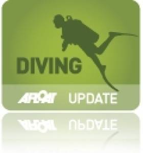
Over the past few weeks the divers have carefully and methodically videoed and photographed the Submarine and taken various measurements to record the wrecks' condition. Over a number of dives the dive team carefully cleaned the growth from the propeller and after some methodical cleaning found the U-Boats number UC42 stamped into it; positively identifying the submarine.
As the submarine is a war grave and contains the remains of so many young German submariners the dive team also laid a plaque of remembrance, which was erected near the submarines propellers; to act as a memorial to the German submariners forever entombed in UC42. The plaque was kindly donated to the dive team by John O' Mahony of Complete Signs.
The image of the U-Boats propellor with the markings identifying the U-Boat. Photo: Timmy Carey
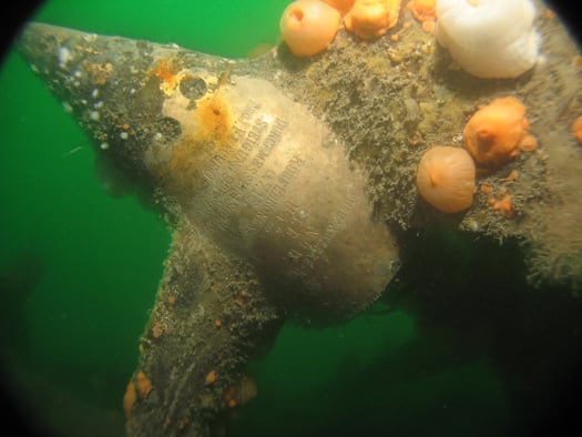
A badly decayed mine on UC42 still in the mine chute. Photo: Timmy Carey
There Is More To The Water Underneath
My time on the water has been spent 'on the surface,' but those who like to go underwater tell me the attractions of diving are magnificent and that Cork Harbour, my sailing base atop the water, is one of the great 'dive spots' on the Irish coastline.
There are many ways to enjoy the water, so I believe in encouraging everyone who takes parts in watersports. That is one way in which appreciation of the importance of the marine sphere can be advanced.
The Irish Underwater Council, Comhairle Fó Thuinn, known by its initials 'CFT,' promotes diving and is the national governing body for recreational underwater sports in Ireland. Through affiliated clubs, it provides training for diving and snorkelling.

"It's time to dive," the CFT says. "We provide the opportunity for recreation and fun in a friendly environment while maintaining a safe and cautious attitude to Irish waters. The basic objective of the training system is to demonstrate, teach and practice all the necessary abilities until the beginner is comfortable with the equipment and basic safety skills. There is no pressure of time limits and training is at the individual's own pace."
The CFT was founded in 1963 when underwater enthusiasts wanted to establish a national group which would organise and promote sport scuba diving and snorkelling. At that time there were six clubs around the country. The number has now expanded to 84.
I was talking in the past week to just one of those clubs - the Cork Sub Aqua Club which is encouraging more people to take up the sport. It has been in existence for 40 years and organises dives on Wednesday evenings during the Summer and on most Sundays throughout the year. There are visits to dive sites outside of Cork and wreck-diving is organised to suit ability and experience. Divers come from all ages and backgrounds, so there is a great opportunity if for anyone interested to get involved.
"We will begin training new recruits in January, so anyone who joins will be ready for open water by the Spring. No experience is necessary," the club says. "Our qualified instructors are waiting for newcomers and, for anyone already qualified, we say join and dive with us."
The photograph on this week's blog shows two divers enjoying their time in the water, even in this cold period of the year. Niall O'Regan from Monkstown in Cork and Ian Kelleher were diving off Roche's Point. They had a look at a trawler which sank in the area back in the mid-80s. The attraction of diving for them is "the great diversity of sea life to be found around the harbour and the quiet and tranquillity underwater in comparison to the hustle and bustle on land." That is a well-expressed sentiment which I like and encourages me to tell you that I am continuing with attempt to develop my idea for the establishment of an Irish maritime foundation. My thanks to those readers of this blog who Emailed me about it. Some good ideas have been put forward and more are always welcome.
For anyone interested you can get more information about the Irish Underwater Council by Emailing: [email protected] or about membership by Email to: [email protected]
You can Email me in response to items on this blog at: [email protected]
This article is reprinted by permission of the EVENING ECHO newspaper, Cork, where Tom MacSweeney writes maritime columns twice weekly. Evening Echo website: www.eecho.ie


