Menu

Ireland's sailing, boating & maritime magazine

Dublin Bay Boating News and Information

Displaying items by tag: Irish Maritime Transport Economist

#MaritimeReport - The 14th edition of the Irish Maritime Transport Economist report produced by the Irish Maritime Development Office (IMDO) on Ireland’s maritime freight industry was launched today. 

The report shows that in 2016, total port traffic increased by 2%, with growth driven predominantly by unitised trade, Roll-on/Roll-off (RoRo) and Lift-on/Lift-off (LoLo) traffic, both of which grew by 7% in 2016.

Also highlighted in the report was an increase of 11% in the number of cruiseship calls to Irish ports, with 274 calls recorded in 2016, while (ferry) passenger numbers between the island of Ireland, Great Britain and continental Europe declined by 2.6% to 4.3 million passengers in 2016.

Key figures

· 2% increase in total port traffic recorded in 2016

· 7% increase in RoRo traffic to 1,073,403 freight units

· 7% increase in LoLo traffic to 916,852 TEUs*

· 5% decline in total bulk traffic, driven by reduced demand for oil, coal and other bulk commodities

· Overall passenger traffic declined 2.6% in 2016, but 11% increase in cruise vessel calls recorded
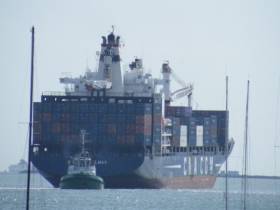
Freight traffic

The growth recorded in unitised trade, which is closely correlated with consumer demand, points to increased consumer confidence in the Irish economy in 2016. With over 80% of RoRo traffic moving between the Republic of Ireland and the United Kingdom, the growth in RoRo traffic recorded in 2016 is also a reliable proxy for the performance of trade between both economies, despite economic and political uncertainty in 2016.

In contrast, total bulk traffic, comprising dry bulk, liquid bulk and break bulk, fell by 5% in 2016 to 28.5 million tonnes. Dry bulk volumes fell by 1% to 15.8 million tonnes and liquid bulk volumes fell by 9% to 11.3 million tonnes in 2016, with demand for commodities in these categories such as animal feeds, fertilizer, coal and oil affected by relatively warm and dry weather conditions. Break bulk traffic fell by 5% to 1.4 million tonnes, mainly driven by a 40% decrease in shipment of refuse derived fuel. When these shipments are excluded, break bulk traffic grew by 2% in 2016, with increases recorded in the shipment of commodities such as cement, which underpin growth in the Irish construction sector.

Passenger traffic

Figures for 2016 show a decline of 2.6% in passenger numbers between the island of Ireland, Great Britain and continental Europe to 4.3 million passengers. The largest decline in passenger traffic was recorded between the Republic of Ireland and Great Britain, with a decline in passenger numbers of 5% to 2.2 million recorded in 2016. This decline in sea passenger traffic is in contract to strong growth in air passenger traffic in 2016. Car volumes to and from the island of Ireland also decreased by 1% in 2016, to 1.28 million.

Ireland’s cruise industry, however, recorded growth in 2016 with an 11% increase in vessel calls in 2016. 274 vessels called to Irish ports in 2016 carrying 442,304 passengers and crew. Dublin Port remained Ireland’s busiest cruise terminal with 109 vessel calls carrying 159,124 passengers and crew, a 7% increase in passenger traffic from 2015.

Speaking at the launch of the 14th edition of the Irish Maritime Transport Economist, Liam Lacey, Director, IMDO, said: “As a maritime nation and an economy, we are heavily dependent on seaborne transport to link Ireland to world markets. While 2016 was a challenging year for business, the overall increase in port traffic and strong growth in unitised trade demonstrates the resilience of Ireland’s maritime industry in continuing to meet the needs of our growing economy. While the impact of Brexit on the trading environment is not immediately apparent in bilateral trade volumes recorded between Ireland and the UK in the second half of 2016, our maritime industry is influenced by factors such as exchange rate fluctuations that will continue to evolve in 2017.”

A full copy of the report can be accessed here.

Published in Ports & Shipping

Dublin Bay

Dublin Bay on the east coast of Ireland stretches over seven kilometres, from Howth Head on its northern tip to Dalkey Island in the south. It's a place most Dubliners simply take for granted, and one of the capital's least visited places. But there's more going on out there than you'd imagine.

The biggest boating centre is at Dun Laoghaire Harbour on the Bay's south shore that is home to over 1,500 pleasure craft, four waterfront yacht clubs and Ireland's largest marina.

The bay is rather shallow with many sandbanks and rocky outcrops, and was notorious in the past for shipwrecks, especially when the wind was from the east. Until modern times, many ships and their passengers were lost along the treacherous coastline from Howth to Dun Laoghaire, less than a kilometre from shore.

The Bay is a C-shaped inlet of the Irish Sea and is about 10 kilometres wide along its north-south base, and 7 km in length to its apex at the centre of the city of Dublin; stretching from Howth Head in the north to Dalkey Point in the south. North Bull Island is situated in the northwest part of the bay, where one of two major inshore sandbanks lie, and features a 5 km long sandy beach, Dollymount Strand, fronting an internationally recognised wildfowl reserve. Many of the rivers of Dublin reach the Irish Sea at Dublin Bay: the River Liffey, with the River Dodder flow received less than 1 km inland, River Tolka, and various smaller rivers and streams.

Dublin Bay FAQs

There are approximately ten beaches and bathing spots around Dublin Bay: Dollymount Strand; Forty Foot Bathing Place; Half Moon bathing spot; Merrion Strand; Bull Wall; Sandycove Beach; Sandymount Strand; Seapoint; Shelley Banks; Sutton, Burrow Beach

There are slipways on the north side of Dublin Bay at Clontarf, Sutton and on the southside at Dun Laoghaire Harbour, and in Dalkey at Coliemore and Bulloch Harbours.

Dublin Bay is administered by a number of Government Departments, three local authorities and several statutory agencies. Dublin Port Company is in charge of navigation on the Bay.

Dublin Bay is approximately 70 sq kilometres or 7,000 hectares. The Bay is about 10 kilometres wide along its north-south base, and seven km in length east-west to its peak at the centre of the city of Dublin; stretching from Howth Head in the north to Dalkey Point in the south.

Dun Laoghaire Harbour on the southside of the Bay has an East and West Pier, each one kilometre long; this is one of the largest human-made harbours in the world. There also piers or walls at the entrance to the River Liffey at Dublin city known as the Great North and South Walls. Other harbours on the Bay include Bulloch Harbour and Coliemore Harbours both at Dalkey.

There are two marinas on Dublin Bay. Ireland's largest marina with over 800 berths is on the southern shore at Dun Laoghaire Harbour. The other is at Poolbeg Yacht and Boat Club on the River Liffey close to Dublin City.

Car and passenger Ferries operate from Dublin Port to the UK, Isle of Man and France. A passenger ferry operates from Dun Laoghaire Harbour to Howth as well as providing tourist voyages around the bay.

Dublin Bay has two Islands. Bull Island at Clontarf and Dalkey Island on the southern shore of the Bay.

The River Liffey flows through Dublin city and into the Bay. Its tributaries include the River Dodder, the River Poddle and the River Camac.

Dollymount, Burrow and Seapoint beaches

Approximately 1,500 boats from small dinghies to motorboats to ocean-going yachts. The vast majority, over 1,000, are moored at Dun Laoghaire Harbour which is Ireland's boating capital.

In 1981, UNESCO recognised the importance of Dublin Bay by designating North Bull Island as a Biosphere because of its rare and internationally important habitats and species of wildlife. To support sustainable development, UNESCO’s concept of a Biosphere has evolved to include not just areas of ecological value but also the areas around them and the communities that live and work within these areas. There have since been additional international and national designations, covering much of Dublin Bay, to ensure the protection of its water quality and biodiversity. To fulfil these broader management aims for the ecosystem, the Biosphere was expanded in 2015. The Biosphere now covers Dublin Bay, reflecting its significant environmental, economic, cultural and tourism importance, and extends to over 300km² to include the bay, the shore and nearby residential areas.

On the Southside at Dun Laoghaire, there is the National Yacht Club, Royal St. George Yacht Club, Royal Irish Yacht Club and Dun Laoghaire Motor Yacht Club as well as Dublin Bay Sailing Club. In the city centre, there is Poolbeg Yacht and Boat Club. On the Northside of Dublin, there is Clontarf Yacht and Boat Club and Sutton Dinghy Club. While not on Dublin Bay, Howth Yacht Club is the major north Dublin Sailing centre.

© Afloat 2020